Site Section
Data & Maps
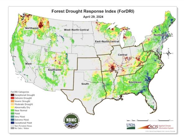
Forest Drought Response Index (ForDRI)
Associated Agencies
National Drought Mitigation Center; U.S. Department of Agriculture U.S. Forest Service; University of Nebraska-Lincoln Center for Advanced Land Management Information Technologies (CALMIT)
The Forest Drought Response Index (ForDRI) is a new combined indicator tool to identify and characterize forest drought stress. The ForDRI presents a weekly depiction of drought-related forest stress across the continental U.S.
ForDRI data and maps are updated every Tuesday at 3:30 p.m. Central Time. The ForDRI maps are produced at a 1-km spatial resolution and provide information about drought's effects on forest regions of the continental U.S. ForDRI integrates data for 12 different environmental variables, including vegetation health (NDVI), climate (SPI, SPEI), evaporative demand (EDDI), groundwater (GRACE groundwater storage), and soil moisture (Noah soil moisture), into a single hybrid index to estimate forest-related drought stress. ForDRI uses a principal component analysis (PCA) method to determine the relative contribution of each input variable based on its covariance for an extended historical record (2003-2020). Historical data of the ForDRI is limited based on the availability of the satellite time series data record.
ForDRI was developed by the National Drought Mitigation Center at the University of Nebraska-Lincoln (UNL) in collaboration with the U.S. Department of Agriculture, U.S. Forest Service, and Center for Advanced Land Management Information Technologies (CALMIT) at UNL.
Documentation
- ForDRI FAQ: This FAQ includes details about the datasets and variables that go into ForDRI, how inputs are weighted, and how the ForDRI team assesses the accuracy of the tool.
- Tadesse, T., Hollinger, D.Y., Bayissa, Y.A., Svoboda, M., Fuchs, B., Zhang, B., Demissie, G., Wardlow, B.D., Bohrer, G., Clark, K.L. and Desai, A.R. 2020. Forest Drought Response Index (ForDRI): A new combined model to monitor forest drought in the eastern United States. Remote Sensing, 12(21), p. 3605.
- USDA Forest Service. National Forest Type Dataset. 2020. Available online: https://data.fs.usda.gov/geodata/rastergateway/forest_type/
- Benedict, T.D., Brown, J.F., Boyte, S.P., Howard, D.M., Fuchs, B.A., Wardlow, B.D., Tadesse, T. and Evenson, K.A. 2021. Exploring VIIRS continuity with MODIS in an expedited capability for monitoring drought-related vegetation conditions. Remote Sensing, 13(6), p. 1210.
Representative Image