Applied Climate Information System (ACIS) - Temperature and Precipitation
NOAA National Centers for Environmental Information (NCEI) Regional Climate Centers (RCCs)
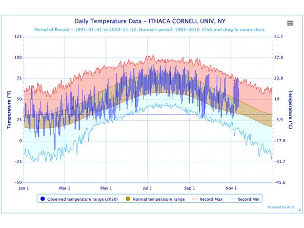
The Regional Climate Centers (RCC) Applied Climate Information System (ACIS) offers interactive charts with single- or multi-station capabilities. Station products include daily or monthly precipitation, temperature, snow depth, snowfall, heating degree days and cooling degree days observations.
How to
What can I do with these data?
- View current and past station based temperature and precipitation data.
How do I use the site?
- Use the interface to select a product from the “Single-Station” or “Muti-Station” drop-down menus. Select from the “Options selection” and select “Go”
- The “Station selection” option allows you to narrow by ID, List, or Search for stations by city, state or zip
- Download image using the “Chart Content Menu” in the upper-right of the chart.
Access
Regional Climate Centers (RCCs) - Applied Climate Information System (ACIS): View temperature or precipitation data at the daily or monthly scales
ACIS Home Page: Landing page for the Applied Climate Information System
High Plains Regional Climate Center (HPRCC) - ACIS Climate Maps: View ACIS climate maps for CONUS, including precipitation, temperature, heating degree days, and cooling degree days
HPRCC GIS Portal: Download shapefiles of ACIS map products
Metadata