Climate Assessment for the Southwest (CLIMAS): Paleoclimate Tool
Climate Assessment for the Southwest (CLIMAS, a NOAA CAP team)
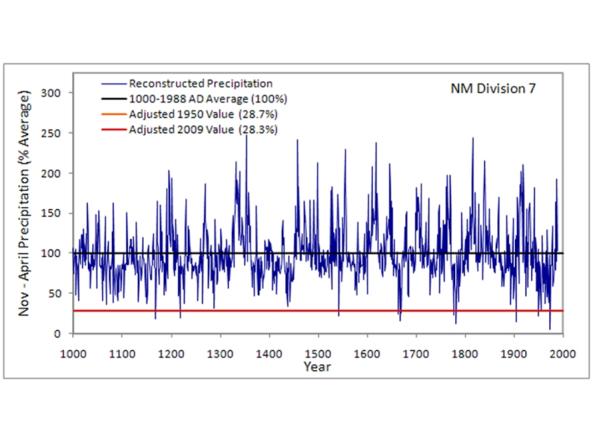
This Climate Assessment for the Southwest (CLIMAS, a NOAA CAP Team) Southwest Paleoclimate Tool provides detailed paleoclimate information for Arizona and New Mexico. The tool allows users to visualize the climate variability during the past 1,000 years or so in each climate division in Arizona and New Mexico.
The longest instrumental records date back only about 100 years in the Southwest, a time frame that likely does not capture the full range of climate variability. Extending the record to earlier times provides additional information on the length and severity of past droughts.
How to
How to use this site:
- Select a climate division from the list on the web page
- For each climate division, you can view single-year and multiple-year precipitation reconstructions for November–April as timeseries graphs and data tables. Values are expressed as a percentage of 1000–1988 average precipitation.
- Read the "How the Data Were Calculated" section to learn more about the methodology.
Access
CLIMAS Paleoclimate Tool: Use the map to view reconstructed data for Arizona/New Mexico state climate divisions.
Tree-Ring Reconstructions of Past Climate in the Southwest: Learn more about the research behind the tool.