IRI Seasonal Climate Forecasts
Columbia University International Research Institute (IRI) for Climate and Society
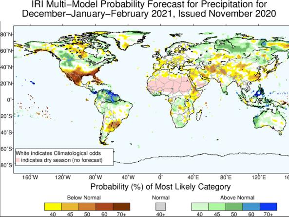
Worldwide predictions for temperature and precipitation from the International Research Institute (IRI) for Climate and Society at Columbia University.
Starting in April 2017, the IRI probabilistic seasonal climate forecast product is based on a re-calibration of model output from the U.S. National Oceanographic and Atmospheric Administration (NOAA)’s North American Multi-Model Ensemble Project (NMME). This includes the ensemble seasonal prediction systems of NOAA’s National Centers for Environmental Prediction, Environment and Climate Change Canada, NOAA/Geophysical Fluid Dynamics Laboratory, NASA, NCAR and COLA/University of Miami. The output from each NMME model is re-calibrated prior to multi-model ensembling to form reliable probability forecasts. The forecasts are now presented on a 1-degree latitude-longitude grid.
How to
How do I use the site?
- Homepage: Use the drop down options to filter between: Regions, Type, Issue Year, Issue Month, and/or Leads to view the maps.
- Interactive Chart:
- Zoom: click and drag an area with your mouse to zoom into a section of the graph
- Unzoom: Click the "Reset Zoom" button in the upper right of the graph window
- Show/Hide: Select the items in the legend (bottom, center) to show or hide the graph values
- Download/Print: Select the icons in the upper right of the graph to print or download the graph as an image
- Map Rooms: allows for customization of layers and formats. Map rooms are available for Flexible Forecasts, Forecasts, Predictions in Context, NMME Forecasts, and Climatological Precentiles. Map Room provide an “Instructions” tab on how to use the map rooms.
Access
Seasonal Climate Forecasts: The home page for Seasonal Climate Forecasts at the International Research Institute for Climate and Society, Earth Institute, Columbia University
Seasonal Climate Forecast Verifications: Interactive Chart that offers download/print options in PNG, JPEG, PDF, and SVG
Seasonal Climate Forecast Map Rooms: Flexible Forecasts, Forecasts, Predictions in Context, NMME Forecasts, and Climatological Percentiles maps that offers download options in KML, WMS, GeoTIFF, GIF, PNG, JPEG and PDF
Documentation
The IRI net assessment is a multi-institutional product made in collaboration with COLA and GFDL. When using IRI forecasts or related data please cite both the published paper describing the dataset and the datasets themselves. Read more about our forecast system, collaborators and recommended references for citation here. A complete list of all IRI’s extensive climate and forecast products both past and present are available in http://iridl.ldeo.columbia.edu/maproom/Global/Forecasts/. Access all climate monitoring and analysis maprooms here.