National Weather Service Fire Weather Outlooks
NOAA / National Weather Service / National Centers for Environmental Prediction / Storm Prediction Center
The National Weather Service (NWS) Storm Prediction Center's Fire Weather Outlooks are intended to delineate areas of the continental U.S. where pre-existing fuel conditions, combined with forecast weather conditions, will result in a significant threat for the ignition and/or spread of wildfires. This product is designed for use in the NWS, as well as other federal, state, and local government agencies. Each outlook consists of a categorical forecast that graphically depicts fire weather risk areas across the continental United States, along with a text narrative.
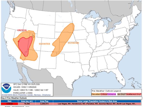
The National Weather Service's Storm Prediction Center produces daily fire weather outlooks, which delineate areas of the continental U.S. where pre-existing fuel conditions, combined with forecast weather conditions, will result in a significant threat for the ignition and/or spread of wildfires. This map shows the 1-day fire weather outlook.
Extreme weather events can interact or cascade—where one disaster event triggers or changes the probability of another event. For example, drought conditions can increase the probability of large-scale wildfires, and droughts are often accompanied by extreme heat. By including drought in multi-hazard planning, a community can consolidate its resources and develop coordinated responses before a disaster.
Learn MoreDuring drought conditions, fuels for wildfire, such as grasses and trees, can dry out and become more flammable. Drought can also increase the probability of ignition and the rate at which fire spreads. Temperature, soil moisture, humidity, wind speed, and fuel availability (vegetation) are all factors that interact to influence the frequency of large wildfires.
Learn MoreForecast Risk of Fire Weather
Elevated
Fire weather conditions are forecast to be elevated for temperature, wind, and relative humidity. Learn more about these designations.
Critical
Fire weather conditions are forecast to be critical for temperature, wind, and relative humidity. Learn more about these designations.
Extremely Critical
Fire weather conditions are forecast to be extremely critical for temperature, wind, and relative humidity. Learn more about these designations.
Isolated Dry Thunderstorms
The Storm Prediction Center has issued a forecast for isolated dry thunderstorms. This heightens the risk of fire ignition due to cloud-to-ground lightning, assuming a dry fuel bed. Learn more about these designations.
Scattered (Critical) Dry Thunderstorms
The Storm Prediction Center has issued a forecast for scattered (critical) dry thunderstorms. This heightens the risk of fire ignition due to cloud-to-ground lightning, assuming a dry fuel bed. Learn more about these designations.
The National Weather Service's Storm Prediction Center produces daily fire weather outlooks, which delineate areas of the continental U.S. where pre-existing fuel conditions, combined with forecast weather conditions, will result in a significant threat for the ignition and/or spread of wildfires. This map shows the 1-day fire weather outlook.
This map is updated daily with data from the National Weather Service's Storm Prediction Center. View more fire weather outlooks.
Extreme weather events can interact or cascade—where one disaster event triggers or changes the probability of another event. For example, drought conditions can increase the probability of large-scale wildfires, and droughts are often accompanied by extreme heat. By including drought in multi-hazard planning, a community can consolidate its resources and develop coordinated responses before a disaster.
Learn MoreDuring drought conditions, fuels for wildfire, such as grasses and trees, can dry out and become more flammable. Drought can also increase the probability of ignition and the rate at which fire spreads. Temperature, soil moisture, humidity, wind speed, and fuel availability (vegetation) are all factors that interact to influence the frequency of large wildfires.
Learn MoreHow to
What can I do with these data?
- Outlook consists of a categorical forecast that graphically depicts fire weather risk areas across the continental United States
How do I use the site?
- Roll your cursor over or click the names/labels of outlook products to view the maps.
- To save image, right-click the map and select “Save Image As...”
What do the fire weather outlook classifications mean?
- ELEVATED: Elevated risk from wind and relative humidity
- CRITICAL: Critical risk from wind and relative humidity
- EXTREME: Extremely critical risk from wind and relative humidity
- ISODRYT: Elevated risk from dry thunderstorms
- SCTDRYT: Critical risk from dry thunderstorms
Access
Day 1 Fire Weather Outlooks: Updates daily
Day 2 Fire Weather Outlooks: Updates daily
Day 3-8 Fire Weather Outlooks: Updates daily and categorical and probability maps for individual days or combined