Quarterly Climate Impacts and Outlook for the Chesapeake Bay Region for December 2020 – February 2021. Dated March 2021.

Quarterly Climate Impacts and Outlook for Hawaii and the U.S. Pacific Islands Region for December 2020 – February 2021. Dated March 2021.
Across the central and eastern equatorial Pacific Ocean, sea-surface temperatures (SSTs) were below normal with La Niña conditions present and a La Niña Advisory still in effect as of the end of February.

Quarterly Climate Impacts and Outlook for Alaska and Northwestern Canada for December 2020 - February 2021; outlook for April - June 2021. Dated March 2021.
Winter started at the beginning of November with the early arrival of a record setting 40cm snowfall. Conditions remained snowy resulting in 66cm depth of snow on the ground at the airport at the end of February. Northwest Canada & Alaska was mostly drier than normal.
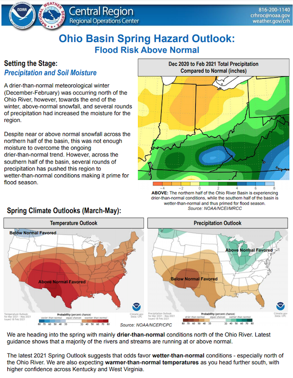
The National Weather Service developed 2021 Spring Hazard Outlooks in coordination with the National Centers for Environmental Information, National Integrated Drought Information System (NIDIS), U.S. Department of Agriculture, National Weather Service River Forecast Centers, and National Interagency Fire Centers' Geographic Area Coordination Centers. This outlook highlights the various Spring hazards that could occur and potential impacts across the Ohio River Valley.

The National Weather Service developed 2021 Spring Hazard Outlooks in coordination with the National Centers for Environmental Information, National Integrated Drought Information System (NIDIS), U.S. Department of Agriculture, National Weather Service River Forecast Centers, and National Interagency Fire Centers' Geographic Area Coordination Centers. This outlook highlights the various Spring hazards that could occur and potential impacts across the Upper Mississippi Valley and Great Lakes.
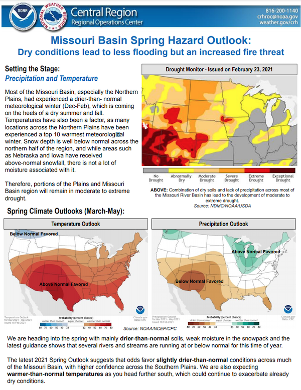
The National Weather Service developed 2021 Spring Hazard Outlooks in coordination with the National Centers for Environmental Information, National Integrated Drought Information System (NIDIS), U.S. Department of Agriculture, National Weather Service River Forecast Centers, and National Interagency Fire Centers' Geographic Area Coordination Centers. This outlook highlights the various Spring hazards that could occur and potential impacts across the Missouri River Basin.
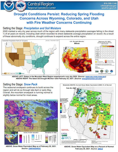
The National Weather Service developed 2021 Spring Hazard Outlooks in coordination with the National Centers for Environmental Information, National Integrated Drought Information System (NIDIS), U.S. Department of Agriculture, National Weather Service River Forecast Centers, and National Interagency Fire Centers' Geographic Area Coordination Centers. This outlook highlights the various Spring hazards that could occur and potential impacts across the Mountain West.
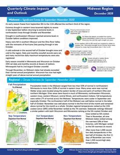
Quarterly Climate Impacts and Outlook for the Midwest Region for September – November 2020. Dated December 2020.
Precipitation totals in the Midwest ranged from less than 50% of normal in northwestern Minnesota to more than 150% of normal in eastern Iowa. Many areas were near normal. Fall temperatures were within 2°F of normal across the Midwest. After more than 1,000 record low daily temperatures in the last half of October, the first 11 days of November saw more than 1,500 record-high daily temperatures.

Quarterly Climate Impacts and Outlook for the Great Lakes Region for September – November 2020. Dated December 2020.
While conditions were overall fairly normal throughout the fall, record-setting warmth, especially in the first half of November, was the most notable event this season. Fall precipitation was below or near average, with the basin seeing 87% of average.

Quarterly Climate Impacts and Outlook for Alaska and Northwestern Canada for September – November 2020; outlook for January – March 2021. Dated December 2020.
A strong storm moved from the northwest Bering Sea, across Chukotka and into the southwest Chukchi Sea November 5 to 7. The storm brought snow and rain to St. Lawrence Island, the Bering Strait and most of the Seward Peninsula. Heavy snow also fell over parts of Interior Alaska on November 5-7 from the same storm system.