Despite Improvement, Drought Remains Firmly Entrenched Across the Missouri River Basin States.
This Missouri River Basin Drought Status Update is released in coordination with the January 19, 2023 North Central U.S. Climate and Drought Outlook Webinar. View the webinar for more details.
Key Points
- Drought remains widespread across many of the states within the Missouri River Basin. Currently 57% of this region is in drought, with the most intense areas in Kansas and Nebraska, where exceptional drought (D4) has persisted since late summer 2022.
- After a very dry fall, much of the Missouri River Basin has received above-normal precipitation so far this winter, with the exception of Kansas, southeastern Nebraska, and portions of Montana and northeast North Dakota.
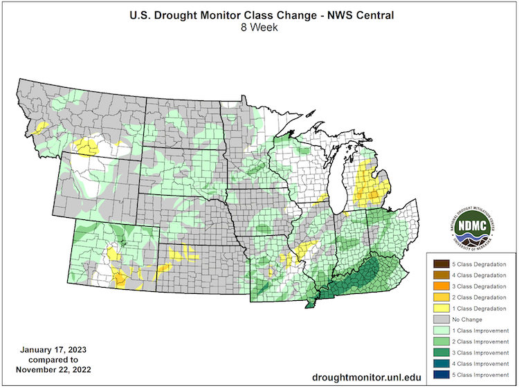
- As a result of the above-normal precipitation, drought in some areas has improved by one to two categories according to the U.S. Drought Monitor since the end of November. On the other hand, portions of Kansas, southeast Colorado, and southern Montana have seen drought conditions worsen by one to two categories.
- Drought impacts are being reported across Kansas and Nebraska. Wheat conditions are very poor in southwest Kansas. Some farmers in this area are tilling or planting cover crops to help keep fields moist to combat blowing dirt issues. Wichita, Kansas entered Stage 1 of its drought response plan on January 10, which calls for voluntary water conservation and the city tries to conserve water in its operations.
- Across Nebraska and Kansas, the soil moisture profile is very low, despite some areas having a wet top layer. Plains fires have not been an issue thankfully, and the outlook for February does not include an above-normal risk for this area either.
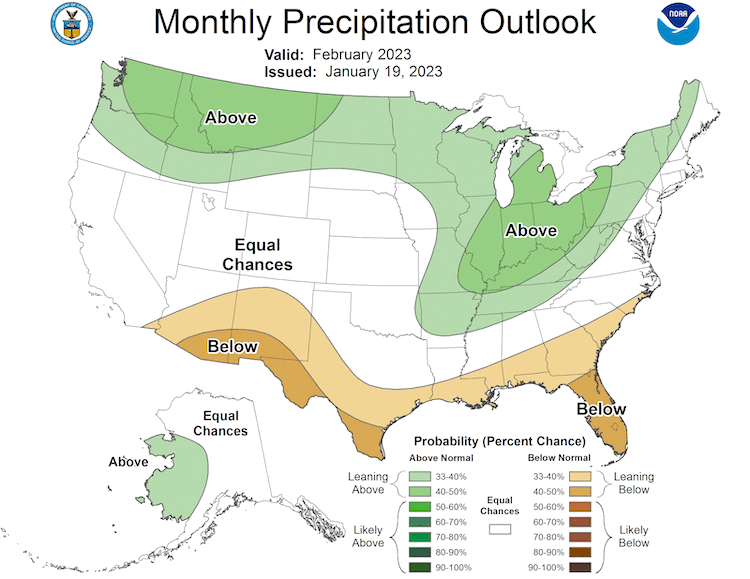
- The February outlook shows the chance for above-normal precipitation to continue across northern portions of the region. However, in Kansas and Nebraska, where the most intense drought remains, there are equal chances for above-, near-, or below-normal precipitation.
- Above-normal precipitation this winter would be helpful to add water to the landscape. However, if soils are frozen, this will limit the ability to replenish soil moisture and therefore improve drought conditions ahead of the upcoming growing season.
- In addition, above-normal precipitation in the winter is not a significant amount of water, as this on average is the driest time of year. Therefore, we will need multiple episodes of soaking rainfall and/or snow melting over thawed soils to significantly improve the areas still in drought.
The U.S. Drought Monitor (USDM) is updated each Thursday to show the location and intensity of drought across the country. Drought categories show experts’ assessments of conditions related to dryness and drought including observations of how much water is available in streams, lakes, and soils compared to usual for the same time of year. This map shows drought conditions for the Missouri River Basin and surrounding areas as of January 17, 2023.
U.S. Drought Monitor Categories
Abnormally Dry (D0)
Abnormally Dry (D0) indicates a region that is going into or coming out of drought. View typical impacts by state.
Moderate Drought (D1)
Moderate Drought (D1) is the first of four drought categories (D1–D4), according to the U.S. Drought Monitor. View typical impacts by state.
Severe Drought (D2)
Severe Drought (D2) is the second of four drought categories (D1–D4), according to the U.S. Drought Monitor. View typical impacts by state.
Extreme Drought (D3)
Extreme Drought (D3) is the third of four drought categories (D1–D4), according to the U.S. Drought Monitor. View typical impacts by state.
Exceptional Drought (D4)
Exceptional Drought (D4) is the most intense drought category, according to the U.S. Drought Monitor. View typical impacts by state.
The U.S. Drought Monitor (USDM) is updated each Thursday to show the location and intensity of drought across the country. Drought categories show experts’ assessments of conditions related to dryness and drought including observations of how much water is available in streams, lakes, and soils compared to usual for the same time of year. This map shows drought conditions for the Missouri River Basin and surrounding areas as of January 17, 2023.
U.S. Drought Monitor 8-Week Change Map

February 2023 Precipitation Outlook

For More Information
- NIDIS and its partners will issue future updates as conditions evolve.
- More local information is available from the following resources:
- To report or view local drought impact information:
- Report your Drought Impacts through Condition Monitoring Observer Reports (CMOR)
- View CoCoRaHS Condition Monitoring reports.
- The North Central U.S. Climate and Drought Summary & Outlook Webinar on January 19, 2023 provided more information about conditions, impacts, and outlooks.
Prepared By
Molly Woloszyn
NOAA/National Integrated Drought Information System (NIDIS), CIRES/CU Boulder
Doug Kluck
NOAA/National Centers for Environmental Information
Dennis Todey
USDA Midwest Climate Hub
This drought status update is issued in partnership between the National Oceanic and Atmospheric Administration (NOAA) and the U.S. Department of Agriculture (USDA) to communicate a potential area of concern for drought expansion and/or development within the Missouri River Basin based on recent conditions and the upcoming forecast. NIDIS and its partners will issue future drought status updates as conditions evolve.


