Colorado River Drought Contingency Planning
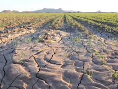
The Colorado River provides water to almost 40 million people and 4 million acres of farmland. Since 2000, historically dry conditions have added stress to the Colorado River’s water resources. As a result, the risk of reaching critically low elevations at Lakes Powell and Mead has increased nearly four-fold over the past decade. Critically low reservoir levels could affect compliance with the 1922 Colorado River Compact; Lake Powell could drop below the level required to generate hydropower; and the economies, livelihoods, and natural resources of the Basin states could be negatively impacted.
To reduce the risk of Lake Powell and Lake Mead declining to critically low levels, in December 2017, the Department of the Interior called on the seven Colorado River Basin States of Wyoming, Colorado, Utah, New Mexico, Arizona, California, and Nevada to put drought contingency plans in place before the end of 2018.
The Colorado River Drought Contingency Plan was submitted to Congress by the states of Arizona, California, Colorado, Nevada, New Mexico, Utah, and Wyoming on March 19, 2019. On April 16, 2019, the Colorado River Drought Contingency Plan Authorization Act was signed into law. This bill requires the Department of the Interior to execute the Colorado River Drought Contingency Plan without delay and operate applicable Colorado River System reservoirs accordingly.
On May 20, 2019, the Secretary of the Interior and the Upper Colorado River Division States of Colorado, New Mexico, Utah, and Wyoming, the State of Arizona, The Metropolitan Water District of Southern California, the Coachella Valley Water District, the Palo Verde Irrigation District, the City of Needles, the Colorado River Commission of Nevada, and the Southern Nevada Water Authority executed a Companion Agreement concerning Colorado River Drought Contingency Management and Operations.
To learn more about the 16-year drought, its effects on the Colorado River Basin, and how drought is being managed in the Basin, the U.S. Geological Survey and U.S. Bureau of Reclamation created this site.
To learn more about Drought Contingency Planning, please visit the U.S. Bureau of Reclamation’s Drought Contingency Plan website.
How is NIDIS Supporting the Colorado River Basin States?
Together with federal, state, local, tribal and private sector partners, NIDIS coordinates and integrates drought research, building upon existing federal, tribal, state, and local partnerships in support of creating a national drought early warning information system. Examples of NIDIS support for Colorado River basin states’ drought early warning, planning and mitigation efforts can be found below:
More Information on the Colorado River Drought Contingency Planning:
- Federal
- Department of Interior:
- August 15, 2019: Reclamation Announces 2020 Colorado River Operating Conditions
- April 9, 2019: Statement by Reclamation Commissioner Brenda Burman on historic legislation to implement Drought Contingency Plans
- March 19, 2019: Department of the Interior Statement on Transmittal of Drought Contingency Plans by the Seven Colorado River Basin States and Key Water Districts to Congress for Implementation
- February 6, 2019: Responding to Historic Drought and Ongoing Dry Conditions in the Colorado River Basin: Request for Input. The Department of the Interior requests input from the Governors of each of the seven Colorado River Basin States
- Oct. 10, 2018: Colorado River Basin States make important progress towards adopting effective Drought Contingency Plans in 2018
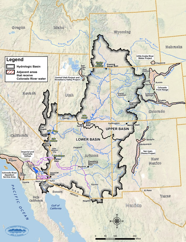
- Data and information about Lake Powell, formed by the Glen Canyon Dam:
- Current reservoir level, current reservoir elevation projections, snowpack progression, current inflow forecasts, model projections, and basin hydrology
- NASA Landsat satellite imagery between 1999 and 2017 documenting changes in the northeastern portion of Lake Powell
- Data and information about Lake Mead, formed by Hoover Dam:
- End of month elevation, annual high and low elevations, historic flow, operations outlook, and 5-year projected conditions
- Colorado River Water Supply and Demand Study
- Department of Interior:
- States
- Water Districts
- Regional
- Upper Colorado River Commission: An interstate water administrative agency established by action of five state legislatures and Congress with the enactment of the 1948 Upper Colorado River Basin Compact. The Commission’s role is to ensure the appropriate allocation of water from the Colorado River to the Upper Division States of Wyoming, Colorado, Utah and New Mexico and to ensure water is released in accordance with the 1922 Colorado River Compact to the Lower Division States of Nevada, Arizona and California and to the Republic of Mexico.
- The Colorado River is managed and operated under numerous compacts, federal laws, court decisions and decrees, contracts, and regulatory guidelines collectively known as the "Law of the River." This collection of documents apportions the water and regulates the use and management of the Colorado River among the seven basin states and Mexico.
- The Layperson’s Guide to the Colorado River
- Tribal