For the latest forecasts and critical weather information, visit weather.gov.
Exceptional Drought Expands in Northern Plains

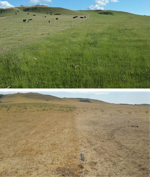
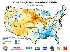
Exceptional Drought – D4, the most severe category – appeared in North Dakota and Montana as of July 18, 2017, according to the U.S. Drought Monitor. As July 25, moderate drought or worse affected about 80 percent of both South Dakota and 80 percent of North Dakota, and most of the eastern half of Montana.
The drought has expanded quickly: Earlier this spring, about 17 percent of South Dakota, none of North Dakota, and less than two percent of Montana were in drought.
On July 19, USDA Secretarial Drought Designations -- which help determine aid availability for agricultural producers -- were in place for 17 primary and 11 neighboring counties in Montana (total 28; 50% of the state’s counties); 27 primary and 9 contiguous counties in North Dakota (36 total - 70% of the state’s counties); and 11 primary with 12 contiguous counties in South Dakota (23 total - 35% of the state’s counties).
The Seasonal Drought Outlook from NOAA’s Climate Prediction Center indicates little relief in sight before the end of October.
In response to the deteriorating conditions, NIDIS and its partners are offering information and resources about how drought is affecting the region, and what might be ahead.
What to find here on drought.gov:
- a calendar of relevant events, including monthly regional climate and drought webinars for the North Central region, which stretches from the Great Lakes/Ohio River Basin to the Rockies.
- current drought indices and indicators in the Dataset Gallery, where you can specify the kind of data you want (soil moisture, outlooks and forecasts, temperature and precipitation, wildfire monitoring and more) and get a brief explanation of the tool.
- information for the region through NIDIS’s Missouri River Basin Drought Early Warning System (DEWS). The DEWS utilizes new and existing networks of federal, tribal, state, local, and academic partners to make climate and drought science accessible and useful for decision makers; and to improve the capacity of stakeholders to monitor, forecast, plan for, and cope with the impacts of drought.
What’s going on in the region now and what might be ahead:
- The weekly U.S. Drought Monitor appears every Thursday with an assessment of drought conditions throughout the nation, in both map and narrative form, with archived data dating back to 2000. Its “change maps” show where conditions have improved or deteriorated over the past week, month, year or longer. The Monitor is a collaborative effort among NOAA and NIDIS, the USDA, the National Drought Mitigation Center (NDMC) and the University of Nebraska-Lincoln, and more than 400 contributors who provide monitoring and impact observations for various regions, states, counties, and communities.
- Weekly regional drought outlook: the High Plains Regional Climate Center (HPRCC) reports on drought conditions for Montana, the Dakotas, Wyoming, Nebraska and Colorado. They also provide a monthly summary of weather and climate conditions and activities. Follow @HPClimateCenter on Twitter for updates, or sign up for an RSS feed of all High Plains news at https://hprcc.unl.edu/rss.xml
- Monthly climate and drought webinars for the North Central region have zeroed in on the Northern Plains. The webinars typically take place on the third Thursday of each month and include time for a Q&A between expert presenters and participants. Sponsors and presenters include the HPRCC, Midwest Regional Climate Center, National Weather Service, NOAA’s National Centers for Environmental Information and others.
- Following the July 20 webinar, the HPRCC and several partners released a two-page Drought Impacts and Outlook briefing for the Northern Plains, summarizing the information in the webinar: climate overview for the last 30 days, summary of drought impacts, and short- and long-term outlooks for the region. You can replay the July 20 webinar at https://hprcc.unl.edu/webinars.php.
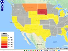
NDMC collects a database of drought impacts through the Drought Impact Reporter. Various agencies and groups as well as individuals can report their observations of drought impacts to this tool, which currently aggregates dozens of impact reports from Montana and the Dakotas.
State activities and resources
-
North Dakota
-
For hay-related help: The North Dakota Department of Agriculture offers an interactive map displaying the information being gathered by its Drought Hotline. The map shows the U.S. Drought Monitor classifications, current radar readings, counties in need of hay, hay and pasture land for rent and hay hauler locations. Or call call the Hay-Hotline North Dakota: 701-425-8454.
-
Weekly maps of drought impacts based on input from county agents, including range and pasture moisture, range utilization and water resources, from North Dakota State University.
-
Monthly climate summaries from the North Dakota State Climate Office.
-
- Montana
- Drought Management web page, which includes monthly statewide drought reports, seasonal water supply reports for various basins in the state, and links to the Montana Hay Hotline. From the Montana Department of Water Resources and Conservation.
- Montana Hay Hotline
- The Montana Climate Office and the National Weather Service Offices in Montana are collaborating on a September two-day workshop focused on climate services for Montana. NIDIS will share information about the Missouri River Basin DEWS effort and resources available across the federal family.
-
South Dakota
-
Drought information summaries from South Dakota State University. For more information, contact South Dakota State Climatologist Laura Edwards.
-
South Dakota state drought dashboard shows current conditions (drought severity, temperature, precipitation, Standardized Precipitation Index (SPI), hydrologic and agricultural information, soil moisture, and forecasts/ outlooks for drought; short- and long-term precip/temp forecasts; as well as projected potential for wildland fire.
-


