AirNow: Air Quality Index Monitoring and Forecasts
U.S. Environmental Protection Agency (EPA), National Oceanic and Atmospheric Administration (NOAA), National Park Service, National Aeronautics and Space Administration (NASA), Centers for Disease Control and Prevention, U.S. Forest Service, U.S. Department of State
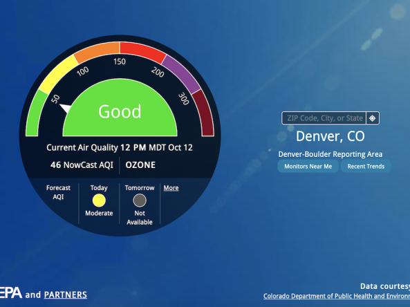
AirNow is a one-stop source for air quality data. AirNow reports air quality using the official U.S. Air Quality Index (AQI), a color-coded index designed to communicate whether air quality is healthy or unhealthy.
The AQI is calculated for four major air pollutants regulated by the Clean Air Act: ground level ozone, particle pollution, carbon monoxide, and sulfur dioxide. For each of these pollutants, EPA has established national air quality standards to protect public health. Of these, ground-level ozone and airborne particles are the two pollutants that pose the greatest threat to human health.
AirNow is a partnership of the EPA, NOAA, National Park Service, NASA, Centers for Disease Control, and tribal, state, and local air quality agencies.
AirNow reports air quality using the official U.S. Air Quality Index (AQI), a color-coded index designed to communicate whether air quality is healthy or unhealthy. This map displays the AQI at sensors across the U.S. alongside the current U.S. Drought Monitor. Air quality data are updated daily at 10 a.m. Eastern.
Air Quality
AQI 0 to 50: Good
Air quality is satisfactory, and air pollution poses little or no risk. Learn more.
AQI 51 to 100: Moderate
Air quality is acceptable. However, there may be a risk for some people, particularly those who are unusually sensitive to air pollution. Learn more.
AQI 101 to 150: Unhealthy for Sensitive Groups
Members of sensitive groups may experience health effects. The general public is less likely to be affected. Learn more.
AQI 151 to 200: Unhealthy
Some members of the general public may experience health effects; members of sensitive groups may experience more serious health effects. Learn more.
AQI 201 to 300: Very Unhealthy
Health alert: The risk of health effects is increased for everyone. Learn more.
AQI >301: Hazardous
Health warning of emergency conditions: everyone is more likely to be affected. Learn more.
AirNow reports air quality using the official U.S. Air Quality Index (AQI), a color-coded index designed to communicate whether air quality is healthy or unhealthy. This map displays the AQI at sensors across the U.S. alongside the current U.S. Drought Monitor. Air quality data are updated daily at 10 a.m. Eastern.
On Drought.gov, Air Quality Index maps are updated daily at 10 a.m. Eastern. View hourly air quality information from AirNow.
Access
AirNow: Home page for EPA's AirNow tool.
Fire and Smoke Map: Interactive map displaying information on ground level air quality monitors recording fine particulates (PM2.5) from smoke and other sources, as well as information on fires, smoke plume locations, and special statements about smoke issued by various sources.
Interactive Map of Air Quality: Interactive map showing data for air quality monitors in the U.S., Canada, and Mexico, including current conditions and forecasts.
National Maps: National maps showing current air quality conditions and air quality forecasts for the U.S.
Air Data: Access outdoor air quality data collected from state, local and tribal monitoring agencies across the United States.
Documentation
Metadata
Download Data
Download data from AirNow via the AirNow API.
Download Air Quality Index (AQI) data from Drought.gov via the NOAA/NCEI Directory or our Google Cloud Storage. Both are publicly accessible, but the latter requires logging in with a Google account. JSON, GeoJSON, and CSV files are available, labeled "epaairnow."