AirNow Fire and Smoke Map
U.S. Environmental Protection Agency (EPA), U.S. Forest Service, University of Washington
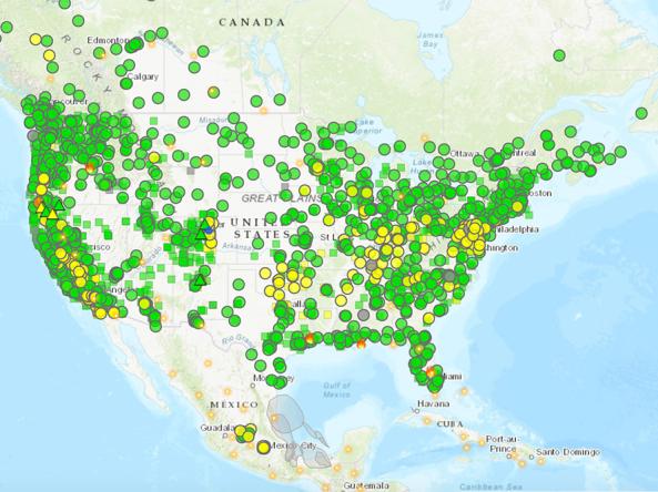
The AirNow Fire and Smoke Map is an interactive map displaying information on ground-level air quality monitors recording fine particulates (PM2.5) from smoke and other sources, as well as information on fires, smoke plume locations, and special statements about smoke issued by various sources.
AirNow reports air quality using the official U.S. Air Quality Index (AQI), a color-coded index designed to communicate whether air quality is healthy or unhealthy.
This map is a collaborative effort between the U.S. Forest Service led Interagency Wildland Fire Air Quality Response Program (IWFAQRP) and the U.S. Environmental Protection Agency. Development work was done through an agreement with the University of Washington’s School of Environmental and Forest Sciences.
AirNow reports air quality using the official U.S. Air Quality Index (AQI), a color-coded index designed to communicate whether air quality is healthy or unhealthy. This map displays the AQI at sensors across the U.S. alongside the current U.S. Drought Monitor. Air quality data are updated daily at 10 a.m. Eastern.
Air Quality
AQI 0 to 50: Good
Air quality is satisfactory, and air pollution poses little or no risk. Learn more.
AQI 51 to 100: Moderate
Air quality is acceptable. However, there may be a risk for some people, particularly those who are unusually sensitive to air pollution. Learn more.
AQI 101 to 150: Unhealthy for Sensitive Groups
Members of sensitive groups may experience health effects. The general public is less likely to be affected. Learn more.
AQI 151 to 200: Unhealthy
Some members of the general public may experience health effects; members of sensitive groups may experience more serious health effects. Learn more.
AQI 201 to 300: Very Unhealthy
Health alert: The risk of health effects is increased for everyone. Learn more.
AQI >301: Hazardous
Health warning of emergency conditions: everyone is more likely to be affected. Learn more.
AirNow reports air quality using the official U.S. Air Quality Index (AQI), a color-coded index designed to communicate whether air quality is healthy or unhealthy. This map displays the AQI at sensors across the U.S. alongside the current U.S. Drought Monitor. Air quality data are updated daily at 10 a.m. Eastern.
On Drought.gov, Air Quality Index maps are updated daily at 10 a.m. Eastern. View hourly air quality information from AirNow.
Access
AirNow Fire and Smoke Map: Interactive map displaying air quality, fire, and smoke conditions
AirNow | Fires: Landing page for wildfire maps, information, fact sheets, and other resources
Documentation