Overview of Weather Water Land Sites (OWWLS)
National Drought Mitigation Center; USDA Northwest, Southwest, and Caribbean Climate Hubs
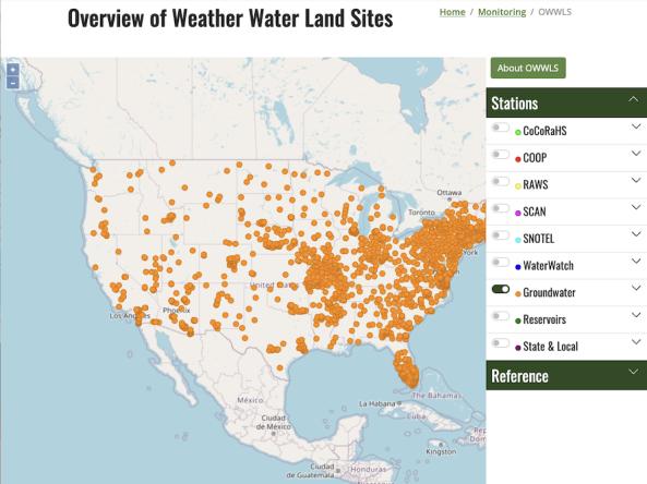
OWWLS, Overview of Weather Water Land Sites, maps the location of weather stations, streamgages, groundwater monitoring stations and reservoirs across the United States, Puerto Rico, and the U.S. Virgin Islands. Data from these stations are used to assess local conditions for the U.S. Drought Monitor. This tool provides information to help climate service providers and partners identify areas with limited or no station-based weather or water data. Identifying gaps in the spatial distribution of monitoring stations can help inform deployment of future stations and recruitment of new observers.
This tool shows station locations along with reference information to provide additional context, such as counties/boroughs/census areas, watersheds, land ownership, land use/land cover, radar coverage, and USDA Climate Hubs.
Note that this is a static map, with most station data downloaded in the Summer of 2023. This tool will not tell you if stations are temporarily out of service. In addition, not all networks, including many state networks, are represented.
OWWLS was originally developed via a collaboration between the National Drought Mitigation Center and the USDA Northwest and Southwest Climate Hubs, supported by the U.S. Department of Agriculture’s Office of the Chief Economist, and was updated in 2023 to inventory weather and water station networks across the United States utilized in the weekly U.S. Drought Monitor process.
Access
How To
- Users can view one or more networks of stations by clicking boxes to toggle networks on and off.
- Click the plus sign next to the description to get more information about stations and reference layers.
- Available station layers include the Community Collaborative Rain, Hail, and Snow Network (CoCoRaHS), NOAA Cooperative Observer Program (COOP), RAWS, SCAN, SNOTEL, USGS WaterWatch, USGS Groundwater Watch, NRCS reservoir data, and state and local station networks.
- Reference layers include boundaries for counties, boroughs, census areas, USDA Climate Hubs, tribal lands, and HUC4 watersheds, as well as radar coverage, land cover, land use, and land ownership type data.