Drought Trade Footprint Study of the Mississippi River
The Mississippi River is an extensive ecological and commercial transportation network that helps make U.S. exports competitive worldwide. When drought conditions exist along the Mississippi River corridor, the impacts are global, affecting livestock production and food prices. The National Integrated Drought Information System (NIDIS), Mississippi River Cities and Towns Initiative (MRCTI), U.S. Department of Agriculture (USDA), U.S. Army Corps of Engineers (USACE), and other partners launched a multiyear study in 2018 to examine the regional and global economic implications of drought along the Mississippi River.
A Drought Snapshot: the Great Plains and Mississippi River
The Great Plains and Mississippi River corridor have experienced a number of severe drought events in the last 100 years, including droughts of the early 1930s, 1988, and 2012. The drought of 2012 was among the most damaging. Across the U.S., precipitation deficits from May through August 2012 were the greatest since official measurements began in 1895, eclipsing the driest summers that occurred during the Dust Bowl (NOAA 2013). By early September 2012, over three-quarters of the contiguous U.S. was experiencing at least abnormally dry conditions with the Great Plains experiencing unprecedented widespread and severe drought. The 2012 Great Plains drought led to nearly $35 billion in direct losses for the U.S., including closing the Mississippi River at least three times. The 2012 Great Plains drought created costly challenges for communities and economic sectors and highlighted the need for greater drought early warning information and preparedness in the region. In response, NOAA’s National Integrated Drought Information System (NIDIS) and its partners convened the first US National Drought Forum in late 2012 and launched the Midwest Drought Early Warning System.
Impacts of Drought on Trade
The Mississippi River basin produces 92% of the nation’s agricultural exports, 78% of the world’s exports in feed grains and soybeans, and most of the livestock produced nationally (NPS 2017). It is also a major recreational resource for boaters, hunters, anglers, and birdwatchers. While local impacts of the 2012 Great Plains drought have been evaluated extensively, it is not well understood how extreme drought impacts the flow of goods and services through the Mississippi River corridor. To address this need, NIDIS, the Mississippi River Cities and Towns Initiative (MRCTI), and other governmental and sectoral partners launched a multi-year study in 2018 to examine the potential impact of drought along the Mississippi River on economic activity associated with agricultural production, commercial river navigation, manufacturing, recreation, and tourism.
Through this study, the following research questions will be explored:
- How does drought impact trade on the Mississippi River in select geographical units (e.g., above/beloW the Ohio River confluence)?
- What are the economic implications of drought in the River corridor when the River’s capacity is limited in providing for commercial river navigation and transportation due to low water levels?
- Where are those impacts felt within the global marketplace?
- What are the economic implications of drought in the Basin on the manufacturing industry along the corridor?
- What are the economic implications of drought in the Basin on the region’s ability to support recreation and tourism along the River?
Collaborating with Communities
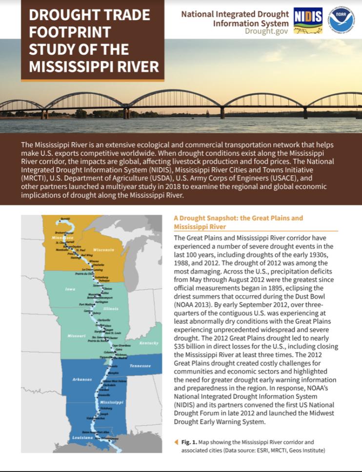
This study spans the length of the Mississippi River main stem corridor from its headwaters in Minnesota to the Louisiana Delta. A critical concern for local governments and businesses in the region is the way in which such events filter to local communities, and the options available to reduce risks, activate alternative economic resources, learn from each other, and seek broader relief when capabilities may be exceeded during particularly severe conditions. To better understand and address long-term drought risk, the study team will identify 3–4 pilot locations to conduct community-based drought vulnerability assessments.
Getting Involved
For more information, please contact Elizabeth Ossowski, NIDIS Program Coordinator, at elizabeth.ossowski@noaa.gov or 303-497-4298.
Key Partners
Department of Commerce Economic Development Administration
Department of Transportation Maritime Administration
Mississippi River Cities and Towns Initiative
NOAA National Integrated Drought Information System
NOAA National Weather Service Lower Mississippi River Forecast Center
NOAA Office of the Chief Economist
U.S. Army Corps of Engineers, Inland Waterways Center of Expertise
U.S. Army Corps of Engineers, Institute for Water Resources
U.S. Census Bureau
USDA Agricultural Marketing Service
USDA Office of the Chief Economist


