
Quarterly Climate Impacts and Outlook for the Midwest Region for March – May 2019. Dated June 2019.
Spring temperatures ranged from several degrees below normal in Minnesota to just above normal in eastern Kentucky. Precipitation was above normal for a large majority of the Midwest.

Quarterly Climate Impacts and Outlook for the Western Region for March – May 2019. Dated June 2019.
Spring temperatures were variable across the West. The North Pacific storm track remained active through the spring season bringing above normal precipitation to much of the West.

Quarterly Climate Impacts and Outlook for the Gulf of Maine Region for March – May 2019. Dated June 2019.
Spring temperatures (averaged over March, April, and May) were as much as 3°C (5°F) below normal. Spring precipitation (accumulated from March–May) was near to above normal in most areas but ranged from 75% to 150% of normal.
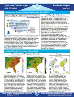
Quarterly Climate Impacts and Outlook for the Southeast Region for March – May 2019. Dated June 2019.
Above-average temperatures were recorded over most of the Southeast. Mean temperatures were 2-4 F above normal for most of the region. Spring precipitation was around 50% to 90% of normal across much of the Southeast, except in western NC, and parts of central NC and AL, where it went up to 130% of normal.
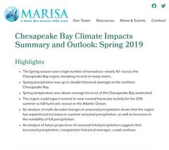
Quarterly Climate Impacts and Outlook for the Chesapeake Bay Region for March – May 2019. Dated June 2019.
Spring temperature was above average for most of the Chesapeake Bay watershed. Spring precipitation was up to double historical averages in the northern Chesapeake Bay.

Quarterly Climate Impacts and Outlook for the Northeast Region for March – May 2019. Dated June 2019.
The Northeast's spring average temperature was near normal, ranking in the middle third of all years. The Northeast received 112% of normal precipitation during spring, ranking in the wettest third of all years.

Quarterly Climate Impacts and Outlook for Hawaii and the U.S. Pacific Islands Region for March – May 2019. Dated June 2019.
Includes significant events, regional climate overview, and sectoral impacts for March – May 2019; regional outlook for June – August 2019.

Current Drought Conditions
As California and Nevada move into summer, the region remains drought free as wet conditions continued through the spring. As of June 4 according to the U.S. Drought Monitor, 4.32% of California remains abnormally dry (D0) due to long term drought while Nevada is drought and dryness free.
Current Drought Conditions
The 2019 Water Year (starting Oct. 1, 2018) was off to a dry start in California-Nevada, but a wet winter has improved drought conditions. For the first time since December 20, 2011, California is drought free as of mid-March according to the U.S. Drought Monitor with less than 7% of the state remaining abnormally dry (D0). Similarly Nevada is drought free as of the end of March with ~10% of the state remaining abnormally dry (D0).

Quarterly Climate Impacts and Outlook for the Midwest Region for December 2018 – February 2019. Dated March 2019.
Winter temperatures for the 3-month period of December to February ranged from a few degrees below normal in the northwest to a few degrees above normal in the southeast. Precipitation was well above normal in the Midwest, ranking as the third wettest winter back to 1895.