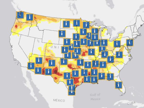
These webinars provide the region's stakeholders and interested parties with timely information on current and developing drought conditions, as well as climatic events like El Niño and La Niña. Speakers also discuss the impacts of these conditions on things such as wildfires, floods, disruption to water supply and ecosystems, as well as impacts to affected industries like agriculture, tourism, and public health.
For more information, please contact Jason Gerlich (jason.gerlich@noaa.gov).
This webinar examined current conditions for the Intermountain West and the forecasted drought conditions for Arizona, Colorado, New Mexico, Utah, and Wyoming.
For more information, please contact Dr. Gretel Follingstad (gretel.follingstad@noaa.gov).
The Atlantic hurricane season is finally winding down in the Southeast. November was warmer than normal across much of the region, with some locations on track to record one of their warmest Novembers on record. While rain along the Atlantic coast brought to an end some exceptionally long and record-breaking dry streaks, drought continued to expand and intensify from the northern Gulf Coast through the interior and northern portions of the region. Extreme Drought (D3) emerged across parts of Alabama and Tennessee.
This five-part webinar series seeks to raise awareness of ecological drought, share actions that strengthen ecosystem resilience and mitigate the impacts of droughts, and highlight advancements in integrating interdisciplinary research and management needs for future drought planning and preparedness.
These webinars provide the region's stakeholders and interested parties with timely information on current and developing drought conditions, as well as climatic events like El Niño and La Niña. Speakers also discuss the impacts of these conditions on things such as wildfires, floods, disruption to water supply and ecosystems, as well as impacts to affected industries like agriculture, tourism, and public health.
For more information, please contact Jason Gerlich (jason.gerlich@noaa.gov).
In August 2024, NIDIS announced up to $4 million in funding for 8 two-year projects as part of the Fiscal Year 2025 NIDIS Coping with Drought: Understanding and Assessing Drought in a Changing Climate competition.
The Southeast region was severely impacted by Hurricane Helene in late September followed by Hurricane Milton in early October. These storms resulted in record or near-record rainfall, flooding, and tornado outbreaks. Those areas that missed the tropical rainfall, such as Alabama and parts of Tennessee, continue to show signs of dryness and drought.
Drought developed or worsened across Oklahoma over the summer. In September, Extreme Drought (D3) expanded over southwest Oklahoma, northwest Texas, and southern Kansas. NOAA’s Climate Prediction Center’s seasonal outlooks predict increased chances for warmer- and drier-than-normal conditions through the end of the year across the Southern Plains and into adjacent states. In fact, parts of eastern Texas that experienced flooding in early summer are now experiencing Moderate Drought (D1), which is likely to worsen in the coming months.
This five-part webinar series seeks to raise awareness of ecological drought, share actions that strengthen ecosystem resilience and mitigate the impacts of droughts, and highlight advancements in integrating interdisciplinary research and management needs for future drought planning and preparedness.
This five-part webinar series seeks to raise awareness of ecological drought, share actions that strengthen ecosystem resilience and mitigate the impacts of droughts, and highlight advancements in integrating interdisciplinary research and management needs for future drought planning and preparedness.
This special drought webinar provided drought information and resources for West Virginia and Ohio, as well as surrounding states in the Midwest and Mid-Atlantic. Topics included the history and evolution of the ongoing drought; current conditions and outlooks for Fall 2024; wildfire risk updates; and ecological impacts as well as impacts across sectors from agriculture to water supply to public health.
“Feast or Famine” continues to be the theme this summer for the Southeast. Hurricane Francine brought beneficial moisture to parts of Alabama, while a persistent frontal boundary led to heavy rain across much of the Florida Peninsula. The rain from Potential Tropical Cyclone Eight contributed to catastrophic flash flooding across southeastern North Carolina. Some rainfall amounts may have exceeded the 1,000-year recurrence interval.
This webinar examined current conditions for the Intermountain West and the forecasted drought conditions for Arizona, Colorado, New Mexico, Utah, and Wyoming.
For more information, please contact Dr. Gretel Follingstad (gretel.follingstad@noaa.gov).
“Feast or famine” was the theme for the Southeast this past month, with most of the region either very wet or very dry. Significant flooding occurred in coastal areas impacted by Hurricane Debby. The region’s interior increasingly dried out after a wet July, with some locations on track to record their driest summer on record. Hurricane Ernesto brought heavy rain and high winds to Puerto Rico and the U.S. Virgin Islands.
These webinars provide the region's stakeholders and interested parties with timely information on current and developing drought conditions, as well as climatic events like El Niño and La Niña. Speakers also discuss the impacts of these conditions on things such as wildfires, floods, disruption to water supply and ecosystems, as well as impacts to affected industries like agriculture, tourism, and public health.
For more information, please contact Jason Gerlich (jason.gerlich@noaa.gov).
In August 2024, NIDIS announced up to $4 million in funding for 8 two-year projects as part of the Fiscal Year 2025 NIDIS Coping with Drought: Understanding and Assessing Drought in a Changing Climate competition.
This webinar examined current conditions for the Intermountain West and the forecasted drought conditions for Arizona, Colorado, New Mexico, Utah, and Wyoming.
For more information, please contact Dr. Gretel Follingstad (gretel.follingstad@noaa.gov).
The hot, dry conditions across much of the region in the past month led to a rapid expansion of drought and reduced streamflows in the Southeast. Some areas experienced record dry conditions (Virginia) and record heat (Raleigh-Durham, North Carolina). Recent rains have brought much needed relief to parts of the region, although the scattered hit-and-miss nature of summer rainfall typical to the Southeast means some areas are still dry, especially in the interior parts of the region, such as Tennessee.
Most of the Southeast region saw above-average temperatures and below-average precipitation this past month. One exception was South Florida, which experienced heavy rain and flooding from an area of low pressure that tracked across the Peninsula around the middle of June. Several locations in Florida, northern Virginia, and the Caribbean are on track to record one of their warmest Junes on record. Abnormal Dryness (D0) emerged across a large portion of the region, while Moderate Drought (D1) emerged across parts of Virginia and Florida.
These webinars provide the region's stakeholders and interested parties with timely information on current and developing drought conditions, as well as climatic events like El Niño and La Niña. Speakers also discuss the impacts of these conditions on things such as wildfires, floods, disruption to water supply and ecosystems, as well as impacts to affected industries like agriculture, tourism, and public health.
For more information, please contact Jason Gerlich (jason.gerlich@noaa.gov).
The Southeast region largely experienced above-average temperatures over the past month, with several locations on track to record one of their hottest spring seasons on record. Drought is largely absent, except in the Florida peninsula. As we transition into the summer, the region as a whole can expect to continue experiencing wet and hot conditions, with normal risk of flooding.
This webinar examined current conditions for the Intermountain West and the forecasted drought conditions for Arizona, Colorado, New Mexico, Utah, and Wyoming.
For more information, please contact Dr. Gretel Follingstad (gretel.follingstad@noaa.gov).
The Southeast U.S. continues to be warmer than normal across much of the region. Drought is largely absent, and many rivers and creeks experienced flooding over the last month.
Warm and wet conditions are expected to continue through the spring and early summer. Drought is not expected to re-emerge widely across the region, although water demand is increasing as we transition into the spring. There is a slightly above-normal risk for river flooding.
These webinars provide the region's stakeholders and interested parties with timely information on current and developing drought conditions, as well as climatic events like El Niño and La Niña. Speakers also discuss the impacts of these conditions on things such as wildfires, floods, disruption to water supply and ecosystems, as well as impacts to affected industries like agriculture, tourism, and public health.
For more information, please contact Jason Gerlich (jason.gerlich@noaa.gov).
Drought is a big deal in Oklahoma. In this webinar, Gary McManus, the Oklahoma state climatologist, provided an overview of Oklahoma's climate, current conditions, trends, drought history, and forecasts. Then, Katie Welch, PhD candidate at Oklahoma State University, explored the economic impact of drought on rural Oklahoma and the impact of drought relief mechanisms on the economy of three Oklahoma counties.
This webinar examined current conditions for the Intermountain West and the forecasted drought conditions for Arizona, Colorado, New Mexico, Utah, and Wyoming.
For more information, please contact Dr. Gretel Follingstad (gretel.follingstad@noaa.gov).
March has been warm, with above average temperatures across most of the region. Many rivers and creeks had flooding in the last month, and drought has largely been eliminated. Spring is here, so temperatures are warming and demand for water increases as plants leaf out. This should help to temper flooding the further into spring we get.
The March Drought & Climate Outlook Webinar provided updates on snow and rangeland conditions in California and Nevada.
The California-Nevada Drought Early Warning System March 2024 Drought & Climate Outlook Webinar is part of a series of regular drought and climate outlook webinars designed to provide stakeholders and other interested parties in the region with timely information on current drought status and impacts, as well as a preview of current and developing climatic events (i.e., El Niño and La Niña).
The National Coordinated Soil Moisture Monitoring Network is hosting a regular online seminar series to share innovative soil moisture research activities.
This seminar explored how soil moisture monitoring information can be used to support water resource and ecological applications by presenting case studies from two headwaters basins of the Colorado River:
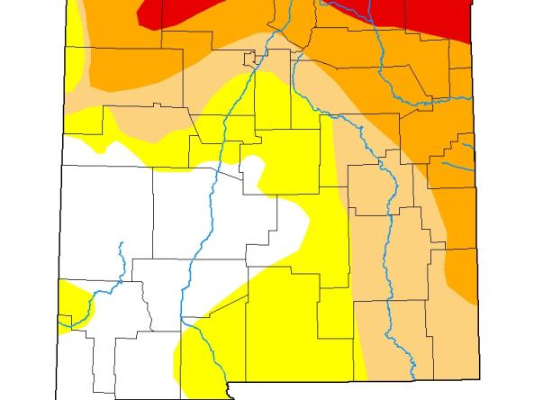
As of March 12, 2024, current drought conditions vary widely across the Intermountain West. The southern states in the region continue to sustain drought conditions with 88.2% of New Mexico in Moderate to Exceptional Drought (D1–D4) and 48.6% of Arizona in Moderate to Extreme Drought (D1–D3). The northern states are reporting less drought with 21.6% of Wyoming in drought, 10% of Colorado, and only 3.8% of Utah in Moderate to Severe drought (D1–D2).
The purpose of this webinar was to increase awareness and utilization of the new COMET training module that teaches National Weather Service (NWS) operational staff to review the appropriate drought products and tools, then craft effective and regionally-specific drought messaging.
El Niño reached “very strong” intensity during the winter months and impacted weather and climate patterns across the Southeast as anticipated. Increased precipitation events and storminess resulted in the elimination of drought across most of the region and produced widespread minor flooding and numerous moderate and major floods over the last month. Looking ahead, river flood risk is expected to stay above normal as we approach spring and El Niño continues to keep the southeast U.S. active.
These webinars provide the region's stakeholders and interested parties with timely information on current and developing drought conditions, as well as climatic events like El Niño and La Niña. Speakers also discuss the impacts of these conditions on things such as wildfires, floods, disruption to water supply and ecosystems, as well as impacts to affected industries like agriculture, tourism, and public health.
For more information, please contact Britt Parker (britt.parker@noaa.gov).
As of February 20, current drought conditions vary widely across the Intermountain West. The southern states in the region continue to sustain drought conditions with 88.2% of New Mexico in drought (D1-D4) and 54.6% (D1-D3) of Arizona. The northern states are reporting less drought with 21.7% of Wyoming in drought, 11.7% of Colorado, and only 3.8% of Utah in drought (D1-D2).
The arrival of rains across the region over the past two months helped eliminate most of the lingering drought from the Fall, with many rivers starting to experience flooding in this early part of flood/recharge season. Looking ahead, river flood risk is expected to stay above normal as we approach the spring and El Niño continues to keep the southeast U.S. in an active precipitation pattern, particularly along the eastern areas. While drought is expected to improve in Alabama and Georgia, it is expected to persist in western Tennessee and the U.S.
In this month's Drought & Climate Outlook Webinar, we discussed current conditions and the Colorado River Science Wiki, a web-based resource for scientific and technical information. Presenters also provided a regular drought and climate update along with perspectives on these conditions from the California and Nevada state climatologists.
Thirty-six percent of the Intermountain West Drought Early Warning System region is in drought, with parts of Arizona, New Mexico, and Colorado in Moderate to Extreme Drought (D1-D3) and Exceptional Drought (D4) in New Mexico.
This webinar examined current conditions for the Intermountain West and the forecasted drought conditions for Arizona, Colorado, New Mexico, Utah, and Wyoming. There was also a special presentation on the Water Adaptation Techniques Atlas.
These webinars provide the region's stakeholders and interested parties with timely information on current and developing drought conditions, as well as climatic events like El Niño and La Niña. Speakers also discuss the impacts of these conditions on things such as wildfires, floods, disruption to water supply and ecosystems, as well as impacts to affected industries like agriculture, tourism, and public health.
How will climate change affect how we assess drought? How can we assess if a drought was made worse because of a warming climate? This webinar, hosted by NOAA's National Weather Service (NWS) and National Integrated Drought Information System (NIDIS), focused on challenges in assessing and communicating drought conditions in a changing climate. The presentations and feedback received during this webinar will help NWS to develop practical field office guidance for messaging drought in a changing climate, based on the best available science.
Current drought conditions vary widely across the Intermountain West. Only 9.6% and 4.8% of the northern states of Utah and Wyoming are in drought, respectively. Meanwhile, the central and southern areas of the region are experiencing Moderate to Exceptional Drought (D1–D4): 26.9% of Colorado is in drought (2.1% in D3), 96.8% of New Mexico is in drought (43% in D3–D4), and 57.2% of Arizona is in drought (6.1% in D3). Short-term and long-term drought persists in the southern portion of the Intermountain West.
This last month has seen above-average temperatures and below-average precipitation across much of the Southeast. The ongoing dryness led to rapidly intensifying and expanding drought across many parts of the region, in particular Alabama, Tennessee, Georgia, and the interior Carolinas. The lack of precipitation and drought conditions led to below-average streamflows and impacted agriculture, wildfire activity, and water supply. A strong El Niño is already in place and is currently strengthening.
The flakes have started to fly in the Sierra Nevada. This month's Drought & Climate Outlook Webinar discussed tools to help monitor incoming precipitation, track snowpack, and look back at past drought conditions. The National Weather Service also provided their regular drought and climate update.
Drought continues to expand and intensify in both the ACF and ACT basins, with strong impacts to the agriculture sector, increased fire risk, and a reduction in many streamflow and lake levels. Drought relief is expected as we approach winter and as the typical excess rainfall and storminess associated with the current El Niño begins to take form. While this upcoming winter recharge/flood season is expected to improve drought conditions, flooding will become an increasing concern.
Monitor Drought Conditions in the ACF and ACT River Basin
Louisiana, Mississippi, and Texas faced Exceptional Drought (D4) conditions for the past year. These have resulted in low river flows through the lower Mississippi River, record-setting fire conditions in Louisiana, and additional hardships for agriculture in the region. Watch the recap to learn more about current and forecasted drought conditions in the region.
Temperatures were cooler than normal for most of the region over the past month, but above average across parts of Tennessee, Alabama, and Florida, and much above average across the Caribbean. Precipitation was below average across most of the region; many places recorded less than half of their expected amounts. These dry conditions led to drought expansion across Alabama, Tennessee, Georgia, and the Carolinas; drought persisted in parts of the U.S. Caribbean and the Florida West Coast.
These webinars provide the region's stakeholders and interested parties with timely information on current and developing drought conditions, as well as climatic events like El Niño and La Niña. Speakers also discuss the impacts of these conditions on things such as wildfires, floods, disruption to water supply and ecosystems, as well as impacts to affected industries like agriculture, tourism, and public health.
This webinar provided local and regional perspectives on approaches for monitoring, predicting, and communicating flash drought, including an overview of the 2023 flash drought in the Midwest. Specifically, it reviewed how flash drought is identified (and noted regional variations), tools for monitoring and predicting flash drought, and guidance for communicating the risk of flash drought. Further, this webinar recapped key takeaways from the 2nd National Flash Drought Workshop, which took place in May 2023.
Temperatures were above average across most of the Southeast region; many locations in Florida recorded their warmest summer on record. Precipitation was below average across most of the region, except in places affected by tropical cyclones. Some locations in the Caribbean have received less than half of their expected rainfall since the start of the year. Drought conditions emerged across northwest Florida and intensified across southern Alabama and the Shenandoah Valley of Virginia. Drought has also intensified in the U.S. Virgin Islands.
We're in for an El Niño winter—and likely a strong one. The El Niño–Southern Oscillation (ENSO) is expected to continue through December 2023 to February 2024, according to the National Weather Service's Climate Prediction Center. El Niño typically brings wet winter weather to California and Nevada, but what areas is this El Niño cycle expected to favor?
Jennifer Schellpeper, Water Planning Division Manager with the Nebraska Department of Natural Resources, provided an overview of the integrated water management approach the state of Nebraska implemented, which integrates planning for hydrologically connected groundwater and surface water.
These webinars provide the region's stakeholders and interested parties with timely information on current and developing drought conditions, as well as climatic events like El Niño and La Niña. Speakers also discuss the impacts of these conditions on things such as wildfires, floods, disruption to water supply and ecosystems, as well as impacts to affected industries like agriculture, tourism, and public health.
NOAA's National Weather Service (NWS) has developed a modernized Drought Information Statement (DGT), a product issued by NWS Weather Forecast Offices (WFOs) that synthesizes local drought conditions, impacts and outlook. On September 1, 2023, NWS launched an exp
This 2023–2024 national webinar series—Strengthening the National Weather Service Drought Toolbox—will enable National Weather Service field office staff, operational meteorologists, climatologists and hydrologists, to embed new drought tools, products, and insights into local and regional drought services.
While the Southwest saw record-setting snowpack in the winter of 2023, the Monsoon season has been nearly non-existent. As a result, short-term drought has increased in New Mexico, and long-term drought conditions persisted in Arizona and Nevada. Recently, Hurricane/Tropical Storm Hilary provided some much needed relief for western states, though the heavy precipitation created flooding issues for the higher elevations. New Mexico did not benefit from that system and is degrading in drought status statewide.
This past month was a ‘Tale of Two Temperatures’ in the Southeast, with below-average temperatures across the interior of the region, while the southern tier and the Caribbean remained hot and humid. Many locations in Florida recorded their warmest month on record in July. Precipitation was also variable. Drought conditions improved across Tennessee and northern Alabama, persisted on St. Thomas and St. Croix, emerged in eastern North Carolina and St. John, and intensified across the western Florida Peninsula and northwestern Puerto Rico.
Temperature varied across the Southeast region, with below-average temperatures across the interior of the region while the southern tier and Caribbean remained hot and humid. Precipitation was also variable where much of Tennessee, Alabama, and Virginia experienced above-average rainfall with some localized flooding, while much of Georgia and Florida were drier than average.
According to the July 18 U.S. Drought Monitor, only 9.5% of California/Nevada is in drought, down from 99% at the start of the water year (October 2022). Drought primarily remains now in parts of southeastern California and southern Nevada, which did not receive above-normal precipitation. The short-term weather concern is extreme heat, which is expected to hit the region this week.
The National Oceanic and Atmospheric Administration (NOAA) and climate partners (U.S. Department of Agriculture, American Association of State Climatologists, National Drought Mitigation Center) co-host monthly North Central U.S. Drought & Climate Outlook webinars, which cover the region from the Rockies to the Great Lakes.
For the second straight month, temperatures were below average across much of the Southeast, particularly across parts of Virginia and the Carolinas. On the other hand, temperatures were quite warm across the southern tip of Florida, Puerto Rico, and the U.S. Virgin Islands, where excessive heat warnings were issued on several days. Precipitation was above average across much of the Southeast, owing to the passage of multiple frontal boundaries and low-pressure systems.
Recent trends in the Missouri River Basin have generally noted an increase in extreme events, including record rainfall, flooding, drought, and increased temperatures. On this webinar, experts from the National Oceanic and Atmospheric Administration, National Drought Mitigation Center, and U.S. Army Corps of Engineers discussed these trends in the Basin. The final presentation examined whether recent runoff trends are attributable to climate change, variability, or some combination of both.
The Southwest saw record-setting snowpack over the past winter. Short-term drought in the region has greatly improved. As the region transitions to summer, what will the melting snowpack mean for reservoir storage and long-term drought? This webinar looked at current and forecasted drought conditions for Arizona, Colorado, New Mexico, Nevada, and Utah and then highlighted the new State pages on drought.gov.
These webinars provide the region's stakeholders and interested parties with timely information on current and developing drought conditions, as well as climatic events like El Niño and La Niña. Speakers also discuss the impacts of these conditions on things such as wildfires, floods, disruption to water supply and ecosystems, as well as impacts to affected industries like agriculture, tourism, and public health.
Despite recent cooler temperatures, many locations in the Southeast are still experiencing one of their warmest starts to the year due to higher temperatures in the first four months. Precipitation was more variable. The region is largely free of drought at this time, with the exception of the Florida Peninsula, Puerto Rico, and the U.S. Virgin Islands. A transition from ENSO-neutral is expected in the next couple of months.
The National Coordinated Soil Moisture Monitoring Network is hosting a quarterly online seminar series to regularly share innovative soil moisture research activities.
According to the May 16 U.S. Drought Monitor, only 12.6% of California/Nevada is in drought, down from 99% at the start of the water year (October 2022). Drought primarily remains now in parts of southeastern California and southern Nevada, which did not receive above-normal precipitation. In Nevada, end of April observations reported that reservoirs were at 33% of capacity, which is 59% of average. Many of California’s major reservoirs are near or above historical averages.
NOAA’s National Integrated Drought Information System (NIDIS), in partnership with NOAA’s National Centers for Environmental Information (NCEI) and National Weather Service’s Climate Prediction Center, hosted the 2023 Western Drought Webinar on May 9 to provide the latest information on current drought conditions and outlooks. Speakers from the U.S.
The start of 2023 could best be described as “warm’’ for much of the Southeast, where most states observed their warmest mean temperatures on record between January and March. Temperatures were above average over the past month. Precipitation was more variable with below-average amounts in the northern and southern ends of the region and above-average amounts across the middle of the region and in southeast Florida.
These webinars provide the region's stakeholders and interested parties with timely information on current and developing drought conditions, as well as climatic events like El Niño and La Niña. Speakers also discuss the impacts of these conditions on things such as wildfires, floods, disruption to water supply and ecosystems, as well as impacts to affected industries like agriculture, tourism, and public health.
The Southwest has seen record-setting snowpack this winter. Short-term drought in the region has greatly improved. As we look forward to the spring melt, what will this mean for reservoir storage and long-term drought? This webinar examined current and forecast drought conditions for Arizona, Colorado, New Mexico, Nevada, and Utah and then highlighted the spring runoff and streamflow forecasts for the Colorado River Basin.
This past month brought a roller coaster of temperature changes to the Southeast, beginning with unseasonably warm weather during the first week of March, followed by cooler weather with subfreezing temperatures during the middle of the month, then a return to unseasonably warm weather at the end of the month. Precipitation was below average across the region, with many locations receiving less than half of their expected amounts.
According to the March 28 U.S. Drought Monitor, 36.7% of California-Nevada is in drought, with no Extreme (D3) or Exceptional (D4) Drought left in the region. Another series of Atmospheric Rivers are drenching the region, bringing a new round of flooding concerns. Does this mean the drought is over? This webinar provided an overview of current conditions and outlooks, as well as California and Nevada rangeland updates.
Short-term drought in the Southwest has greatly improved while long-term drought continues. This webinar looked at current and forecast drought conditions for Arizona, Colorado, New Mexico, Nevada, and Utah, followed by an introduction to the Community Collaborative Rain, Hail, and Snow Network (CoCoRaHS).
For more information, please contact Joel Lisonbee (joel.lisonbee@noaa.gov).
These webinars provide the region's stakeholders and interested parties with timely information on current and developing drought conditions, as well as climatic events like El Niño and La Niña. Speakers will also discuss the impacts of these conditions on things such as wildfires, floods, disruption to water supply and ecosystems, as well as impacts to affected industries like agriculture, tourism, and public health.
Note: A glitch in the recording appears later in the video that caused the audio and visuals to be out of sync. We apologize for this issue.
Temperatures were above average over the past two months, except during an Arctic Outbreak that affected the broader region in late December. Recent rains have helped eliminate drought across the interior of the region, with some dry areas still remaining along the coastal Florida Panhandle to the Delmarva Peninsula. Streamflows are currently near normal across most of the region, as we head into the peak of recharge season in the southeast U.S.
According to the January 17 U.S. Drought Monitor, 95.4% of California-Nevada is in drought. But as a series of atmospheric rivers drenched the region, the immediate threat turned to flooding. But what does that mean for the drought? This webinar provided an overview of the current conditions and outlooks, a demonstration of the WestWide Drought Tracker, and perspectives on the current drought from the California and Nevada state climatologists.
These webinars provide the region's stakeholders and interested parties with timely information on current and developing drought conditions, as well as climatic events like El Niño and La Niña. Speakers will also discuss the impacts of these conditions on things such as wildfires, floods, disruption to water supply and ecosystems, as well as impacts to affected industries like agriculture, tourism, and public health.
Note: A glitch in the recording appears later in the video that caused the audio and visuals to be out of sync. We apologize for this issue.
According to the November 22 U.S. Drought Monitor, 99.7% of California-Nevada is in drought, with 41.9% in Extreme (D3) or Exceptional (D4) Drought. This webinar provided an overview of the current conditions and outlooks as well as tools you can use to prepare for, monitor, and respond to the drought conditions this winter.
About This Webinar:
Drought conditions continue to impact the Lower Mississippi River Basin, with over 73% of the Lower Mississippi watershed in moderate to extreme drought (D1–D3) and river levels recently hitting record lows in some areas. To provide the latest information on current drought conditions, impacts felt across economic sectors, and short-term and long-range outlooks, NOAA’s National Integrated Drought Information System (NIDIS) in partnership with NOAA’s National Weather Service, the U.S. Army Corps of Engineers, and the U.S.
The National Coordinated Soil Moisture Monitoring Network (NCSMMN) is hosting a quarterly online seminar series to regularly share innovative soil moisture research activities.
The last month was unseasonably warm in the Southeast, with much above-average temperatures reported across many locations. Most of the region continued to remain dry due to low precipitation rates, which has led to the continuation and gradual expansion of drought in many areas. The exception is those areas affected by Hurricane Nicole, which made landfall in Florida on November 10. Nicole resulted in significant coastal erosion and property damage; it is the first November hurricane to strike Florida in 37 years.
Drought continues in the Southwest and with another La Niña pattern looming in the Pacific, the winter ahead is expected to be drier than normal. This webinar looked at current and forecast drought conditions for Arizona, Colorado, New Mexico, Nevada, and Utah. It also provided a quick introduction to the Forest Drought Indicator (ForDRI), a monitoring tool developed by the National Drought Mitigation Center to identify forest drought stress.
The American Association of State Climatologists (AASC) and NOAA’s National Integrated Drought Information System (NIDIS) co-hosted this webinar to provide an introduction to Climate Engine for state climatologists and related climate service professionals.
In May 2022, NOAA's Climate Prediction Center (CPC) began issuing an experimental Rapid Onset Drought risk product within CPC’s Day 8-14 (“Week-2”) U.S. Hazards Outlook. This product highlights areas where rapid drought development (sometimes known as “flash drought”) may occur in the coming 2–4 weeks as depicted by the U.S. Drought Monitor.
Temperatures were much below average over the past month, highlighted by an early season freeze/frost that resulted in over 80 daily minimum temperature records in the region from October 18–21. Precipitation was mostly below average, except in areas affected by Hurricane Ian. Ian made multiple landfalls in the Southeast at the end of September as one of the strongest and deadliest hurricanes in the state of Florida. Drought continues to expand in areas that have not received precipitation, in particular in Alabama, Georgia, and the Florida Panhandle.
These webinars provide the region's stakeholders and interested parties with timely information on current and developing drought conditions, as well as climatic events like El Niño and La Niña. Speakers also discuss the impacts of these conditions on things such as wildfires, floods, disruption to water supply and ecosystems, as well as impacts to affected industries like agriculture, tourism, and public health.
The U.S. Geological Survey (USGS) and NOAA’s National Integrated Drought Information System (NIDIS) hosted a series of listening sessions on Drought Prediction and Water Availability to seek input on priorities and needs related to predicting water availability changes under drought conditions at national and regional scales. This input will be used to guide USGS Drought Program planning and orientation, as well as to inform other national drought programs.
The Southwest is in continuing drought. This webinar looked at current and forecast drought conditions for Arizona, Colorado, New Mexico, Nevada, and Utah. It also highlighted a recent research project from Utah State University that used Twitter to track and predict changing drought conditions.
Temperatures and precipitation were variable across the region this past month, with most of the region exhibiting slightly above-average temperatures and below-average rainfall. Streamflows are currently near normal across most of the region. Pockets of moderate drought have returned to northeastern North Carolina and southeastern Virginia.
According to the September 20 U.S. Drought Monitor, 99.9% of California/Nevada is in drought, with 42.9% in extreme (D3) or exceptional (D4) Ddrought. All eyes are on the fall and winter outlooks with the hope for a better snow year even as La Niña is favored to continue through winter 2022–23.
This Midwest DEWS research webinar highlighted results from a NIDIS-funded research study that analyzed the rapid transitions in precipitation extremes in the Midwest. The goal of this research study, led by Dr. Trent Ford at the University of Illinois and Dr. Liang Chen at the University of Nebraska-Lincoln, was to improve our understanding of rapid transitions between precipitation extremes in the Midwest, their causes, and the future risk they pose to the region.
The Southwest is in continuing drought. Recent summer rains have improved but not removed drought from the Southwest. This webinar will look at current and forecast drought conditions for Arizona, Colorado, New Mexico, Nevada, and Utah. Despite a wet summer, the Great Salt Lake has hit a historic, all-time low water level; this webinar will also look at the recently released Great Salt Lake Hydro Mapper tool developed by USGS and State of Utah.
The U.S. Geological Survey (USGS) and NOAA’s National Integrated Drought Information System (NIDIS) are holding a series of listening sessions on Drought Prediction and Water Availability to seek input on priorities and needs related to predicting water availability changes under drought conditions at national and regional scales. This input will be used to guide USGS Drought Program planning and orientation, as well as to inform other national drought programs.
These webinars provide the region's stakeholders and interested parties with timely information on current and developing drought conditions, as well as climatic events like El Niño and La Niña. Speakers also discuss the impacts of these conditions on things such as wildfires, floods, disruption to water supply and ecosystems, as well as impacts to affected industries like agriculture, tourism, and public health.
The Southwest is in a continuing drought. This webinar looked at how recent monsoon rain has changed drought conditions for Arizona, Colorado, New Mexico, Nevada, and Utah. This webinar also took a closer look at drought monitoring using data and tools from the USDA Agricultural Research Service research in partnership with PhenoCam Network.
Temperatures and precipitation were highly variable across the region this past month. Precipitation was generally wetter across the region, which helped alleviate some of the drought conditions. However, there was still much variation in precipitation, which is typical of July. Streamflows are near normal across most of the region.
The Southern Plains has been in extreme to exceptional drought since September 2021. This drought has been dynamic, changing almost month to month through the winter and spring. Intense heat and the rapid intensification of drought conditions through June and July made this webinar ever more timely.
The U.S. Geological Survey (USGS) and NOAA’s National Integrated Drought Information System (NIDIS) are holding a series of listening sessions on Drought Prediction and Water Availability to seek input on priorities and needs related to predicting water availability changes under drought conditions at national and regional scales. This input will be used to guide USGS Drought Program planning and orientation, as well as to inform other national drought programs.
Most of the Southeast region was hot and dry for the past 30 days. Temperatures were above average and included some record highs. Precipitation was variable, but generally below average for most of the region. The heat and dryness have contributed to the intensification of drought conditions in the region including the eastern Carolinas and Georgia, with agricultural impacts being observed.
These webinars provide the region's stakeholders and interested parties with timely information on current and developing drought conditions, as well as climatic events like El Niño and La Niña. Speakers will also discuss the impacts of these conditions on things such as wildfires, floods, disruption to water supply and ecosystems, as well as impacts to affected industries like agriculture, tourism, and public health.
Note: A glitch in the recording appears later in the video that caused the audio and visuals to be out of sync. We apologize for this issue.
This webinar provided a summary of winter and spring climate conditions in the Missouri Basin that have led to the current depiction of drought. It also included an outlook on what to expect this summer. Also, we discussed the current state of fire conditions in the Plains and the outlook for the summer.
Drought in Oklahoma began in fall 2021 and has expanded and worsened during early 2022. The U.S. Drought Monitor shows over one-third (36%) of the state in Extreme (D3) Drought and nearly a tenth (9.4%) in Exceptional (D4) Drought. During this webinar, Gary McManus, the Oklahoma State Climatologist, and Victor Murphy, from the National Weather Service, talked about current drought conditions, the long-range forecast, and the impact recent precipitation had on drought conditions across the state.
The Southeast region experienced near-average temperatures in the last 30 days. Precipitation, in general, was variable and below average for most of the region. This dryness has contributed to the gradual intensification of drought conditions in some parts of the region, including the eastern Carolinas and southern Florida. Streamflows are near normal across most of the Southeast with the exception being coastal North Carolina and southern Virginia, where they are below normal.
The U.S. Geological Survey (USGS) and NOAA’s National Integrated Drought Information System (NIDIS) are holding a series of listening sessions on Drought Prediction and Water Availability to seek input on priorities and needs related to predicting water availability changes under drought conditions at national and regional scales. This input will be used to guide USGS Drought Program planning and orientation, as well as to inform other national drought programs.
Drought in Texas has expanded and worsened during early 2022. The US Drought monitor shows 53.5% of the state in Extreme (D3) or Exceptional (D4) drought, the highest percentage since February of 2012. In this webinar John Nielsen-Gammon, Texas State Climatologist, and Victor Murphy, with the National Weather Service, talked about current drought conditions, the long-range forecast, and the impact recent precipitation had on drought conditions across the state.
According to the April 19, 2022 U.S. Drought Monitor, 70.2% of the Pacific Northwest Drought Early Warning System (DEWS) is in drought, with 22.4% of the region in Extreme/Exceptional Drought (D3/D4). While water availability in some areas of Washington and Idaho has improved over the winter months, much of southern and eastern Oregon and portions of Idaho recorded their driest 3-month January-March on record.
This monthly briefing, hosted by the National Oceanic and Atmospheric Administration (NOAA) and climate partners (U.S. Department of Agriculture, American Association of State Climatologists, National Drought Mitigation Center), covers the region from the Rockies to the Great Lakes.
The Southeast region experienced near-average temperatures the last 30 days with recent spring temperature swings. Although precipitation has been hit or miss due to the springtime thunderstorms, streamflows are mostly near-to-above normal across the region. Drought conditions persist in the eastern Carolinas and southern Georgia. Anticipated rain over the next week will help improve this precipitation deficit, but this still needs to be monitored carefully as the region continues through the spring and water demand increases.
The Southwest has experienced an on-again, off-again winter snow pattern. As we prepare for the spring snowmelt, moderate (D1) to exceptional (D4) drought persists across the region. This drought briefing focused on winter drought conditions and forecasts for spring for Arizona, Colorado, New Mexico, Nevada, and Utah. It also took a closer look at April 1 snowpack conditions along with a deeper dive into snow data and how this year's snowpack will translate into runoff and streamflow through spring.
The National Integrated Drought Information System (NIDIS) and the National Weather Service (NWS) hosted two webinars on soil moisture data and applications. These webinars were intended to help NWS operational forecasters and other weather & climate service providers better understand soil moisture monitoring and its practical applications.
According to the March 22 U.S. Drought Monitor, 100% of California/Nevada is in drought, with 36.8% in extreme (D3) or exceptional (D4) drought. Most of the western U.S. was exceptionally dry in February, with record low total precipitation at over 200 SNOTEL sites. In California, the driest January and February in state history has led to a March 1 statewide snowpack of less than 70% of average, down from 160% at the start of the new year. With low reservoir carryover, the impacts of snow drought will reach into summer and beyond.
The Southeast region experienced a winter that could not make up its mind! December was dry and warm, January was cooler with more precipitation, and February leaned to drier and warmer conditions. The recent dryness is concerning because, for much of the region, this is the time of the year when river flooding peaks (except for the Florida peninsula) and water recharge takes place. However, streamflows are mostly below normal, especially across the Carolinas and in some parts of Alabama, Georgia, and Florida.
The U.S. Geological Survey (USGS) and NOAA’s National Integrated Drought Information System (NIDIS) are holding a series of listening sessions on Drought Prediction and Water Availability to seek input on priorities and needs related to predicting water availability changes under drought conditions at national and regional scales. This input will be used to guide USGS Drought Program planning and orientation, as well as to inform other national drought programs.
The Pacific Northwest Drought Early Warning System Drought & Climate Outlook Webinar is part of a series of regular drought and climate outlook webinars designed to provide stakeholders and other interested parties in the region with timely information on current drought status and impacts, as well as a preview of current and developing climatic events (i.e., El Niño and La Niña).
The most recent U.S. Drought Monitor indicates that much of the Southwest is experiencing some level of drought. Following a fairly dismal November, a wet December, and a dry January, so far February has had a few good precipitation events. How will this winter's precipitation impact the long-term drought conditions in the Southwest? This short drought briefing focused on winter drought conditions and forecasts for Arizona, Colorado, Nevada, New Mexico, and Utah.
The National Integrated Drought Information System (NIDIS) and the National Weather Service (NWS) hosted two webinars on soil moisture data and applications. These webinars were intended to help NWS operational forecasters and other weather & climate service providers better understand soil moisture monitoring and its practical applications.
Nevada’s variable climate makes drought preparedness not only important but challenging. To effectively address some of the challenges faced in the drought planning process, the Nevada Division of Water Resources is collaborating with the Desert Research Institute (DRI), the Nevada State Climate Office, and the National Oceanic and Atmospheric Administration (NOAA) through the National Integrated Drought Information System (NIDIS) program to facilitate three virtual workshops aimed at improving drought planning, mitigation, and communication in Nevada.
The U.S. Geological Survey (USGS) and NOAA’s National Integrated Drought Information System (NIDIS) webinar served as the kickoff to a series of listening sessions to seek input on priorities and needs related to predicting water availability changes under drought conditions at national and regional scales. This input will be used to guide USGS Drought Program planning and orientation, as well as to inform other national drought programs.
Nevada’s variable climate makes drought preparedness not only important but challenging. To effectively address some of the challenges faced in the drought planning process, the Nevada Division of Water Resources is collaborating with the Desert Research Institute (DRI), the Nevada State Climate Office, and the National Oceanic and Atmospheric Administration (NOAA) through the National Integrated Drought Information System (NIDIS) program to facilitate three virtual workshops aimed at improving drought planning, mitigation, and communication in Nevada.
A more active pattern of precipitation in January and early February helped alleviate drought conditions following a dry November and December. We are still in a La Niña Advisory, and it should continue through April. The three-month outlook shows a higher probability of above-normal temperatures and below-normal precipitation. Streamflow levels are moving back to normal.
This Midwest DEWS research webinar presented results from a NIDIS-funded research study that was recently published in the Journal of Hydrometeorology.
The most recent U.S. Drought Monitor indicates that nearly all of the Southwest is experiencing some level of drought. Following a fairly dismal November, December precipitation has improved, but not eliminated, drought conditions. This short drought briefing focused on winter drought conditions and forecasts for Arizona, Colorado, Nevada, New Mexico, and Utah.
For more information, please contact Joel Lisonbee (joel.lisonbee@noaa.gov).
According to the January 25 U.S. Drought Monitor, 99.6% of California/Nevada is in drought, with 9.8% in extreme (D3) or exceptional (D4) drought. The area in D3/D4 is down from 69.9% just one month ago, reflecting the barrage of storms that brought rain and snow to the region in December. These storms have improved conditions but not ended the drought. The current drought developed over many months to years and left huge water deficits.
December was warm with several temperature records broken across the Southeast region. Recent precipitation events have improved streamflows and reduced some of the drought severity across the region. A cold outbreak later this month could freeze some areas, but should not reach too far into Florida. This month’s topical presentation discussed hourly precipitation trends in the Southeast.
Following an active tropical season and wet summer, the Southeast region is becoming drier. A below-normal amount of precipitation for this time of year is leading to lower streamflows and drought conditions, especially in the Carolinas and parts of Virginia. The current La Niña is expected to continue through the winter, with drier and warmer than normal conditions predicted for much of the region.
The most recent United States Drought Monitor indicates that all of the Southwest is experiencing some level of drought, but early fall precipitation has improved conditions. This short drought briefing focused on winter drought conditions and forecasts for Arizona, Colorado, Nevada, New Mexico, and Utah. This was followed by a presentation on landscape water conservation during drought.
The Pacific Northwest Drought Early Warning System Drought & Climate Outlook Webinar is part of a series of regular drought and climate outlook webinars designed to provide stakeholders and other interested parties in the region with timely information on current drought status and impacts, as well as a preview of current and developing climatic events (i.e., El Niño and La Niña).
This webinar provided a current overview of drought conditions in the Northern Great Plains, as well as an outlook on what to expect this winter and going into the spring. Also, we discussed the Mesonet station program run by South Dakota State University and opportunities to gather the best available data on tribal lands.
The most recent United States Drought Monitor indicates that nearly all of the Southwest is experiencing some level of drought, but summer and early fall precipitation has improved conditions. This short drought briefing focused on winter drought conditions and forecasts for Arizona, Colorado, New Mexico, Utah, and Nevada. This month's presentation was by Dr. Erin Saffell, from Arizona State University and the Arizona State Climatologist.
According to the November 16 U.S. Drought Monitor, 100% of California/Nevada is in drought, with 70.6% in Extreme (D3) or Exceptional (D4) Drought. An exceptional atmospheric river (AR5) brought rain, snow, and wind to Northern California and Nevada in late October. This AR and recent storms improved drought conditions but have not come close to ending the drought for the region. The current drought developed over many months to years, leaving soils parched.
The most recent U.S. Drought Monitor indicates that nearly all of the Southwest is experiencing some level of drought, but summer and fall precipitation has improved conditions. This short drought briefing focused on autumn drought conditions and forecasts for Arizona, Colorado, New Mexico, Utah, and Nevada. This was followed by some case studies on effective management practices.
For more information, please contact Joel Lisonbee (joel.lisonbee@noaa.gov).
The Pacific Northwest Drought Early Warning System (PNW DEWS) Drought & Climate Outlook Webinar is part of a series of regular drought and climate outlook webinars designed to provide stakeholders and other interested parties in the region with timely information on current drought status and impacts, as well as a preview of current and developing climatic events (i.e., El Niño and La Niña).
This webinar, which is the fourth in a series focused on the drought in the Northern Plains, highlighted long-term drought monitoring for tribal resource departments by showcasing the Sac and Fox Nation of Missouri in Kansas and Nebraska and their data collecting and preparation efforts for drought in the region.
According to the September 9 U.S. Drought Monitor, 100% of California and Nevada are in drought, with 79.6% in Extreme (D3) or Exceptional (D4) Drought. Continued drying has enhanced wildfire risk throughout the region, reflected in several continuing very large wildfires in northern California. Further, forecasts increasingly reflect the potential for La Niña development in the fall and into the winter.
The most recent United States Drought Monitor indicates that nearly all of the Southwest is experiencing some level of drought. Recent monsoonal rain has improved drought conditions, but extreme and exceptional drought persists for much of the region. This short drought briefing focused on drought conditions for Arizona, Colorado, New Mexico, Utah, and Nevada, followed by the seasonal climate outlooks and an overview of forecast products from the Climate Prediction Center.
This was the second of two webinars to share project findings on drought indices and indicators that support the monitoring and management of different drought types in the northeast United States. The webinar included an overview of several drought monitoring tools and data sources developed by the project team, including:
This webinar shared project findings on drought indices and indicators that support the monitoring and management of different drought types in the northeast United States. The objective of this two-year project was to identify the most effective drought indicators for hydrologic and agricultural drought monitoring in the NIDIS Northeast Drought Early Warning System (DEWS). This includes identifying appropriate time scales related to long-term and short-term drought, and identifying responsive indicators of flash drought development.
The most recent United States Drought Monitor indicates that nearly all of the Southwest is experiencing some level of drought, but recent monsoonal rain is improving drought conditions. This drought briefing focused on how the monsoon is impacting drought conditions and provided a general update of current drought conditions and forecasts for Arizona, Colorado, New Mexico, Utah, and Nevada.
The Pacific Northwest Drought Early Warning System (PNW DEWS) Drought & Climate Outlook Webinar is part of a series of regular drought and climate outlook webinars designed to provide stakeholders and other interested parties in the region with timely information on current drought status and impacts, as well as a preview of current and developing climatic events (i.e., El Niño and La Niña).
This is a National Oceanic and Atmospheric Administration (NOAA) and U.S. Department of Agriculture (USDA) webinar briefing that covers the region from the Rockies to the Great Lakes. Due to the recent dry and hot conditions across the North Central U.S., we will be holding a special webinar on August 5 at 10 a.m. CDT to discuss conditions, impacts, and outlooks through the end of the summer. This is in addition to the regular monthly series, which is scheduled for August 19 at 1 p.m. CDT.
Drought in the Northern Plains continues to worsen, and widespread impacts are being felt, including impacts on tribal lands in the region. In order to provide up-to-date information on the drought and its impacts, and associated resources for tribal nations, the National Oceanic and Atmospheric Administration (NOAA), U.S. Geological Survey, and U.S. Department of Agriculture (USDA) have partnered to host a drought webinar series this summer specifically for the tribal nations in the Northern Plains.
This competition will focus on the implementation of actions—together with research on those actions—to build tribal drought resilience contained in existing plans and strategies. Plans may include, but are not limited to, drought contingency plans; drought, water, or natural resource plans; agricultural resource management plans; or climate adaptation plans.
The FY22 Coping with Drought: Ecological Drought competition will focus on research to improve our understanding, early warning, and management of drought risk in terrestrial and aquatic ecosystems to inform more deliberate and expanded decision-making that supports sustainable, healthy, and resilient ecosystems.
According to the June 22, 2021 U.S. Drought Monitor, 79.8% of the Pacific Northwest Drought Early Warning System (DEWS) is in drought. Washington, Oregon, and Idaho all experienced their second driest March–May period on record (since 1895), and drought conditions have continued to expand throughout the region, which could contribute to increased wildfire potential. Summer is here and record-shattering heat along with it.
Drought in the Northern Plains continues to worsen, and widespread impacts are being felt, including impacts on tribal lands in the region. In order to provide up-to-date information on the drought and its impacts, and associated resources for tribal nations, the National Oceanic and Atmospheric Administration (NOAA), U.S. Geological Survey, and U.S.
Droughts are often categorized as ‘flash’ droughts when they develop or intensify in a matter of weeks (though defining flash droughts continues to be an area of active debate). The National Integrated Drought Information System (NIDIS) and the National Weather Service (NWS) held a series of three webinars to help climate professionals and operational service providers better understand this phenomenon, its defining characteristics and how it varies by region and season, its impacts on agricultural and other stakeholders, and the potential for improved monitoring, prediction, and plann
The most recent United States Drought Monitor indicates that all of the Southwest is experiencing some level of drought, and forecasts indicate these conditions are expected to continue through summer. In this short drought briefing, Jon Meyer from the Utah Climate Center provides an update of current drought conditions and forecasts for Arizona, Colorado, New Mexico, Utah and Nevada.
Drought in the Northern Plains continues to worsen, and widespread impacts are being felt, including impacts on tribal lands in the region. In order to provide up-to-date information on the drought and its impacts, and associated resources for tribal nations, the National Oceanic and Atmospheric Administration (NOAA), U.S. Geological Survey, and U.S. Department of Agriculture (USDA) have partnered to host a drought webinar series this summer specifically for the tribal nations in the Northern Plains.
The Drought Update and Wildfire Outlook Webinar for California and the Southwest was designed to provide stakeholders and other interested parties in the region with timely information on the current drought status and outlook and wildland fire potential outlook.
This was a special joint region webinar, combining the California-Nevada Drought Early Warning System Drought & Climate Outlook Webinar Series and Southwest Drought Briefings, which are produced by the Intermountain West Drought Early Warning System and the USDA Southwest Climate Hub.
According to the April 20, 2021 U.S. Drought Monitor, 56.6% of the Pacific Northwest Drought Early Warning System (DEWS) is in Moderate Drought (D1). Additionally, a pocket of Exceptional Drought (D4) was added to Oregon, the first time that state has had D4 since 2015. Snow conditions this winter have been good in Washington and northern Oregon, and average to below average throughout the rest of the Pacific Northwest. What's the outlook for the rest of spring into summer?
The most recent U.S. Drought Monitor indicates that all of the Southwest is experiencing some level of drought, and forecasts indicate these conditions are expected to continue through spring. In this short drought briefing, Arizona State Climatologist, Nancy Selover, provided an update of current drought conditions and forecasts for Arizona, Colorado, New Mexico, Utah, and Nevada. Dannele Peck, from the Northern Plains Climate Hub, then presented the latest grassland productivity forecast for the Southwest using the Grass-Cast tool.
According to the March 16 U.S. Drought Monitor, 90.6% of California and 100% of Nevada are in drought. The winter wet season is almost over, and there's little chance for snowpack to reach normal levels. Worse, this is the second year in a row with below-normal snowpack. This webinar discussed current conditions and outlooks, as well as an overview of California and Nevada rangeland conditions.
The Pacific Northwest Drought Early Warning System (PNW DEWS) Drought & Climate Outlook Webinar is part of a series of regular drought and climate outlook webinars designed to provide stakeholders and other interested parties in the region with timely information on current drought status and impacts, as well as a preview of current and developing climatic events (i.e., El Niño and La Niña).
Nearly 50% of the Southwestern United States is currently experiencing the most severe drought classification (D4) conditions. The most recent U.S. Drought Monitor indicated that all of the Southwest was experiencing drought, and drought is expected to continue throughout the winter and into spring. This webinar will provide an update of current drought conditions and forecasts for Arizona, Colorado, New Mexico, Utah, and Nevada, followed by a demonstration of the new Drought.gov website.
These webinars provide the region's stakeholders and interested parties with timely information on current and developing climate conditions, such as drought, floods, and tropical storms, as well as climatic events like El Niño and La Niña. Speakers may also discuss the impacts of these conditions on topics such as wildfires, agriculture production, disruption to water supply, and ecosystems. The February 9 webinar also featured a presentation on 2020 in review.
Drought has traditionally been viewed in terms of its agricultural, hydrological, and socioeconomic impacts. However, this does not fully address the impacts to ecosystems, and the critical services they provide to humans. In 2017, an Ecological Drought Framework was developed by the U.S.
This webinar provides updated information on the climate, water, and drought status of the Apalachicola-Chattahoochee-Flint (ACF) River Basin. This drought assessment webinar is brought to you by the Auburn University Water Resources Center and the National Integrated Drought Information System (NIDIS).
According to the January 19 U.S. Drought Monitor, 95% of California and 99.7% of Nevada are in drought. We're at a crossroads where remaining winter snowfall is going to be crucial for the region. Unfortunately, much of the Sierra Nevada is currently below normal for snow water equivalent. This webinar will provide an overview of the current conditions and outlook for the rest of winter as well as an overview of the new Drought.gov website.
Nearly 40% of the Southwestern United States is currently experiencing the most severe drought classification (D4) conditions. On January 12, the U.S. Drought Monitor indicated that all of the Southwest was experiencing drought and drought is expected to continue throughout the winter and into spring.
The Southeast Climate Monthly Webinar series is held on the 2nd Tuesday of each month at 10:00 am ET. This series is hosted by the Southeast Regional Climate Center, the National Integrated Drought Information System (NIDIS) and the NOAA National Weather Service. These webinars provide the region with timely information on current and developing climate conditions such as drought, floods and tropical storms, as well as climatic events like El Niño and La Niña.
These monthly webinar presentations provided information on current and upcoming weather and climate conditions in New Mexico, with a highlight on conditions on tribal lands. Agricultural producers and land managers were encouraged to attend.
The webinars took place on June 25, July 23, August 27, and September 24, 2020. You can view recordings of all webinars on the NIDIS YouTube channel:
As the Colorado River Basin experienced 2020’s “sneaky drought” amid a long-term pattern that looks increasingly like one of the region’s millennial “megadroughts” that last decades, water managers have worked on ways to adapt. Where have we seen success, and which communities are vulnerable as climate change continues to eat away a river on which 40 million people depend?
Severe and persistent 21st-century drought in southwestern North America motivates comparisons to medieval megadroughts and questions about the role of anthropogenic (human-caused) climate change. This webinar is based on research that used hydrological modeling and new 1,200-year tree-ring reconstructions of summer soil moisture to demonstrate that the 2000–2018 southwestern North American drought was the second driest 19-year period since 800 CE, exceeded only by a late-1500s megadrought.


