Most of New England saw beneficial precipitation resulting in improvements to drought conditions
For more details, see the Northeast Drought Early Warning System Dashboard.
- Most of New England, except Vermont, received from 1-4 inches of precipitation during the weekend of Dec. 5-6.
- Extreme Drought (D3) was removed from southern New Hampshire (ridding the NE DEWS of D3 for the first time since mid-September this year), but Severe Drought (D2) remained.
- While most of Maine improved to a nearly drought free status, Moderate Drought (D1) and Abnormally Dry (D0) conditions lingered, particularly along the coast.
- Moderate Drought (D1) also improved to Abnormally Dry (D0) conditions in southeast New England.
- Moderate Drought (D1) expanded slightly in the Adirondacks.
- Abnormally Dry (D0) conditions expanded slightly in northeastern New York and western Vermont.
- More than half (approximately 55%) of the Northeast DEWS region is still experiencing Abnormally Dry (D0) to Severe Drought (D2).
U.S. Drought Monitor Conditions: Northeast |
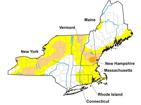
U.S. Drought Monitor map of the Northeast. Valid December 8, 2020. Published December 10, 2020.
State Reported Impacts
New Hampshire
New Hampshire Groundwater Level Monitoring Report for November 2020 has been released.
The majority of the wells in the network are experiencing below normal to low groundwater levels, although water levels in about half of the wells in the network have risen since last month. Overburden well CVW-04 in Concord, and overburden wells in Campton, Deerfield, Franklin, and New Durham have been below normal to low for a 6-month period. The overburden wells in Newport have been below normal to low for almost a year. The bedrock wells in East Kingston and Hooksett have been below normal to low for a 6-month period. The dug well in New London and the overburden well in Barnstead have recovered to normal since last month. (NH DES).
Outlooks
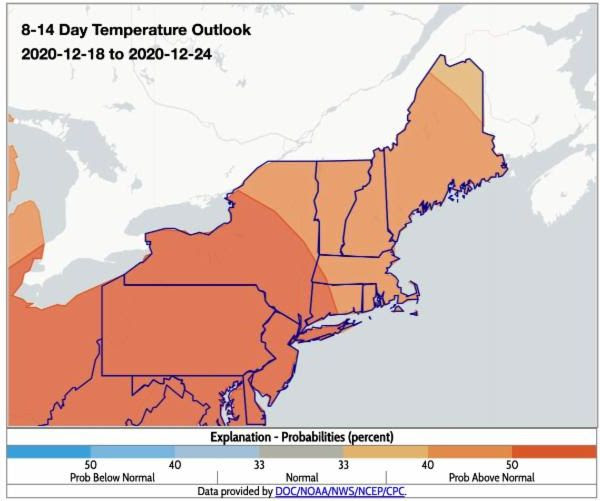
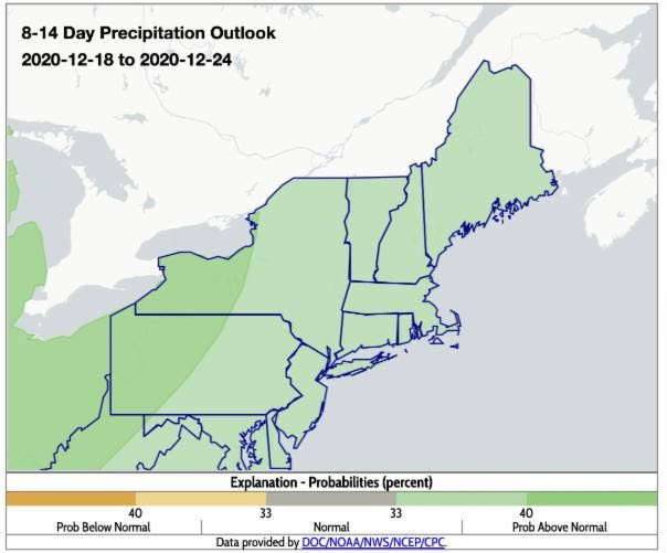
- The 8-14 day maps indicate above-normal temperatures and above-normal precipitation for the Northeast.
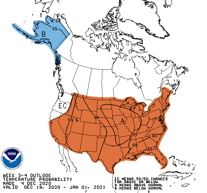
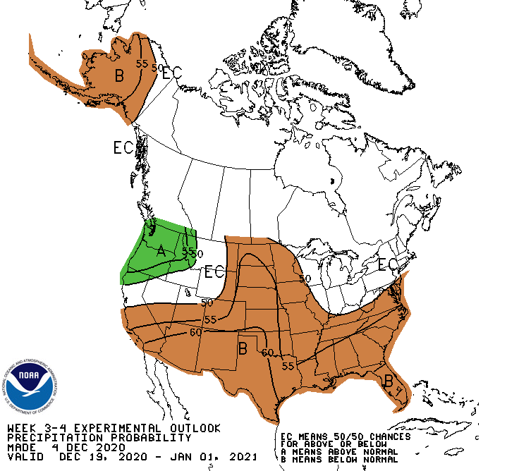
- The 3-4 week outlook favors above-normal temperatures and equal chances for above- or below-normal precipitation for the Northeast.
Temperature Outlook 8-14 Day
Precipitation Outlook 8-14 Day
Temperature Outlook Week 3-4
Precipitation Outlook Week 3-4
Current CPC Outlooks: https://www.cpc.ncep.noaa.gov/
Additional Resources
- Northeast DEWS Dashboard
- NOAA Regional Climate Services
- Your local National Weather Service office
- NOAA Regional Climate Services Monthly Webinar Series (November 19 next webinar)
- USDA Northeast Climate Hub
- USGS/New England and New York Water Science Centers
Contacts for More Information
Sylvia Reeves
Regional Drought Information Coordinator (Northeast DEWS)
NOAA/CIRES/National Integrated Drought Information System (NIDIS)
Email: sylvia.reeves@noaa.gov
Ellen L. Mecray
Regional Climate Services Director, Eastern Region
NOAA/NESDIS/National Centers for Environmental Information
Email: Ellen.L.Mecray@noaa.gov
Sylvia Reeves
NOAA/National Integrated Drought Information System (NIDIS)
Samantha Borisoff, Jessica Spaccio, Keith Eggleston, Art DeGaetano
Northeast Regional Climate Center
Ellen Mecray
Regional Climate Services Director, Eastern Region, NOAA
David Hollinger and Maria Janowiak
USDA Climate Hubs
Gardner Bent
USGS/New England Water Science Center
In partnership with National Weather Service Offices of the Northeast and State Climate Offices of the Northeast.
This Drought Early Warning Update is issued in partnership between the National Oceanic and Atmospheric Administration (NOAA), U.S. Geological Survey, and the U.S. Department of Agriculture (USDA) to communicate concern for drought expansion and intensification within the Northeast U.S. based on recent conditions and the forecasts and outlooks. NIDIS and its partners will issue future Drought Early Warning Updates as conditions evolve.


