Water Year 2024 recap: California-Nevada welcomed a normal precipitation year, but dried out after a hot summer
Key Points
- Much of California and Nevada received near-normal precipitation throughout the 2024 Water Year. After a dry start, the region benefited from late season storms in February and March.
- Near-record summer temperatures dried out the landscape, increasing the percentage of California-Nevada that is Abnormally Dry (D0) or in drought from 1.96% on June 1 to 85.47% on October 1.
- Severe Drought (D2) developed in southern Nevada and southeastern California since the start of Water Year 2025, in part due to a lack of summer monsoon activity.
- Despite recent dryness, reservoir levels throughout the region remain at or above historical averages.
- The 2024 fire season thus far was higher than 2023, but below recent averages. Elevated risk for significant wildland fire remains along southern coastal California.
- The start of Water Year 2025 has been dry, building on the preexisting conditions. Current outlooks indicate a wet pattern in the short term (next 2 weeks) and equal chances of above-normal, normal, or below-normal precipitation in the long term. Regularly tracking the forecast and outlooks will be important as we move into the wetter months.
This update is based on data available as of Thursday, October 17, 2024 at 9:00 a.m. PT. We acknowledge that conditions are evolving.
This map shows drought conditions in California and Nevada as of October 15, 2024.
The U.S. Drought Monitor depicts the location and intensity of drought across the country. The map uses 5 classifications: Abnormally Dry (D0), showing areas that may be going into or are coming out of drought, and four levels of drought (D1–D4).
The U.S. Drought Monitor is a joint effort of the National Oceanic and Atmospheric Administration, U.S. Department of Agriculture, and National Drought Mitigation Center.
This U.S. Drought Monitor 52-week change map shows where drought has improved, degraded, or remained the same from October 3, 2023 to October 1, 2024.
Yellow shades indicate drought degradation, while green shades indicate drought improvement, according to the U.S. Drought Monitor.
U.S. Drought Monitor Categories
D0 - Abnormally Dry
Abnormally Dry (D0) indicates a region that is going into or coming out of drought. View typical impacts by state.
D1 - Moderate Drought
Moderate Drought (D1) is the first of four drought categories (D1–D4), according to the U.S. Drought Monitor. View typical impacts by state.
D2 - Severe Drought
Severe Drought (D2) is the second of four drought categories (D1–D4), according to the U.S. Drought Monitor. View typical impacts by state.
D3 - Extreme Drought
Extreme Drought (D3) is the third of four drought categories (D1–D4), according to the U.S. Drought Monitor. View typical impacts by state.
D4 - Exceptional Drought
Exceptional Drought (D4) is the most intense drought category, according to the U.S. Drought Monitor. View typical impacts by state.
Total Area in Drought (D1–D4)
Percent area of the California-Nevada Drought Early Warning System that is currently in drought (D1–D4), according to the U.S. Drought Monitor.
Drought Degradation
5-Category Degradation
Drought/dryness has worsened by 5 categories, according to the U.S. Drought Monitor.
4-Category Degradation
Drought/dryness has worsened by 4 categories, according to the U.S. Drought Monitor.
3-Category Degradation
Drought/dryness has worsened by 3 categories, according to the U.S. Drought Monitor.
2-Category Degradation
Drought/dryness has worsened by 2 categories, according to the U.S. Drought Monitor.
1-Category Degradation
Drought/dryness has worsened by 1 category, according to the U.S. Drought Monitor.
Drought Improvement
1-Category Improvement
Drought/dryness has improved by 1 category, according to the U.S. Drought Monitor.
2-Category Improvement
Drought/dryness has improved by 2 categories, according to the U.S. Drought Monitor.
3-Category Improvement
Drought/dryness has improved by 3 categories, according to the U.S. Drought Monitor.
4-Category Improvement
Drought/dryness has improved by 4 categories, according to the U.S. Drought Monitor.
5-Category Improvement
Drought/dryness has improved by 5 categories, according to the U.S. Drought Monitor.
This map shows drought conditions in California and Nevada as of October 15, 2024.
The U.S. Drought Monitor depicts the location and intensity of drought across the country. The map uses 5 classifications: Abnormally Dry (D0), showing areas that may be going into or are coming out of drought, and four levels of drought (D1–D4).
The U.S. Drought Monitor is a joint effort of the National Oceanic and Atmospheric Administration, U.S. Department of Agriculture, and National Drought Mitigation Center.
This U.S. Drought Monitor 52-week change map shows where drought has improved, degraded, or remained the same from October 3, 2023 to October 1, 2024.
Yellow shades indicate drought degradation, while green shades indicate drought improvement, according to the U.S. Drought Monitor.
This U.S. Drought Monitor is released every Thursday morning, with data valid through Tuesday at 7 a.m. ET.
This U.S. Drought Monitor (USDM) and USDM change maps are released every Thursday morning, with data valid through Tuesday at 7 a.m. ET.
Current Drought Conditions for California/Nevada
- Much of California and Nevada received 70%–130% of normal precipitation in Water Year 2024 (October 1, 2023–September 30, 2024) (Figure 1).
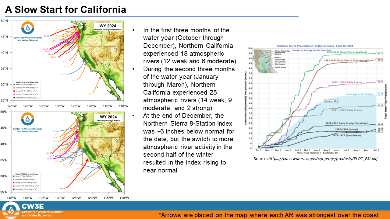
- More atmospheric rivers made landfall along the California coast between late January and March than October–December, which helped mitigate a dry start to the water year. Read more from the Center for Western Weather and Water Extremes (CW3E) (Figure 3).
- California and Nevada average daily summer (June–August) temperatures were 3–7°F warmer than normal (Figure 4). This region recorded its second warmest daily minimum temperature during summer months in a record going back 125 years.
- April 1 median snow water equivalent (SWE) was above normal this year (Figure 5).
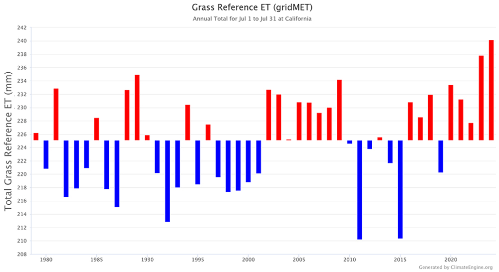
- Evaporative demand peaked during summer months throughout the region, largely due to high temperatures. California set a record for the highest statewide evaporative demand in July (with a record dating back to 1979) (Figure 6).
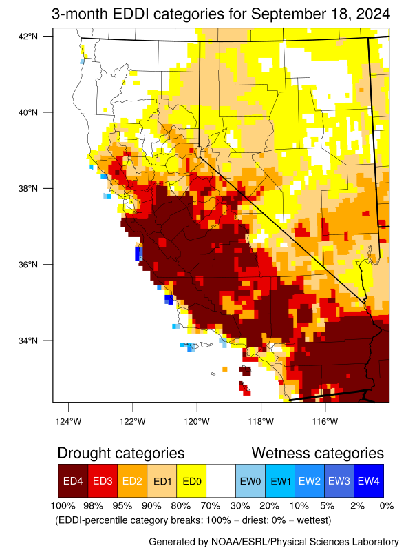
- Drought and dry conditions expanded throughout California and Nevada during the summer months, indicating the impact of the high evaporative demand on the region.
Figure 1: Percent of Normal Water Year Precipitation (October 1, 2023–September 30, 2024)
Key Takeaway: Much of California-Nevada received near-normal precipitation in Water Year 2024 (within about 30% of normal), with the exception of the southeast portion of the California-Nevada region and portions of coastal southern California .
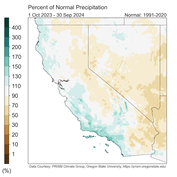
Figure 2: How Many Normal Water Years Would It Take to Make Up Water Year 2024 Precipitation Deficits?
Key Takeaway: Much of the Sierra Nevada and Nevada are missing between 0%–25% of a normal water year’s worth of precipitation. The southeastern portion of the region is missing between 25%–50% in part due to low summer monsoon activity.
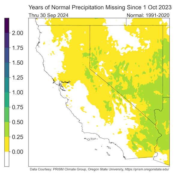
Figure 3: U.S. West Coast Atmospheric River Landfall Map for Water Year 2024
Key Takeaway: California was impacted by a total of 54 atmospheric rivers (ARs) during Water Year 2024, though only 2 were strong or greater.
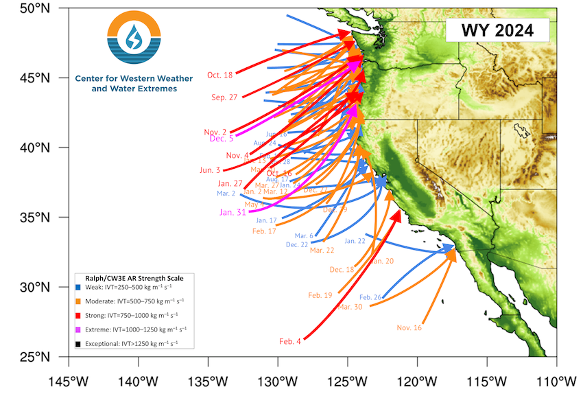
Figure 4: Temperature Anomalies for Water Year 2024 and June–August 2024
Key Takeaway: Water Year 2024 temperatures were normal to slightly above normal (1–3°F) for much of California and Nevada. Summer temperatures were well above normal (3–7°F) throughout much of the region. The exception during both periods is coastal California.
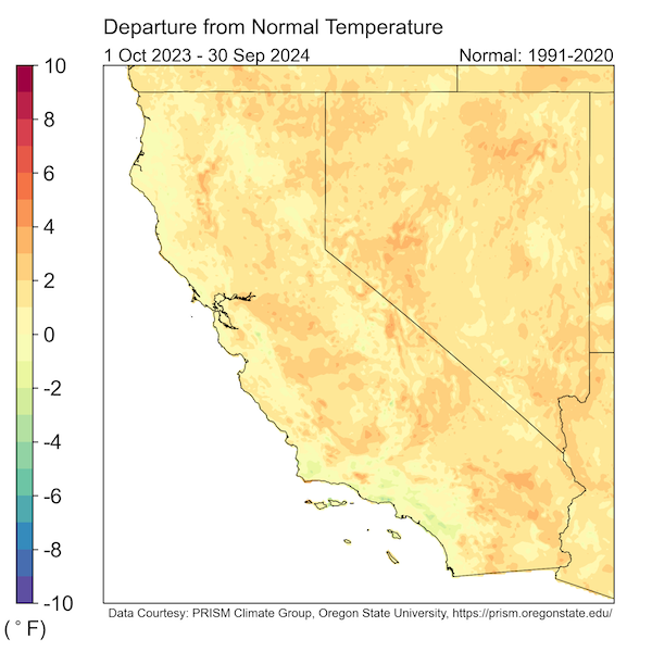
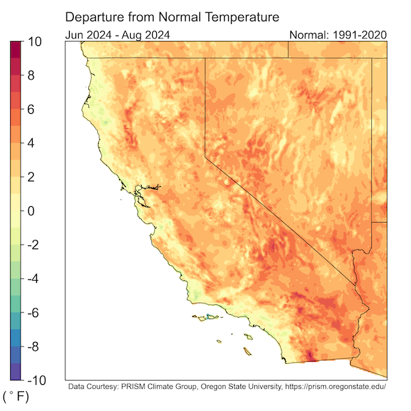
Figure 5: April 1 Snow Conditions in the California–/Nevada Region
Key Takeaway: On April 1, snowpack throughout much of the Sierra Nevada Mountains was above normal, with about 125% to more than 150% of above-normal snowpack in much of northern and central Nevada.
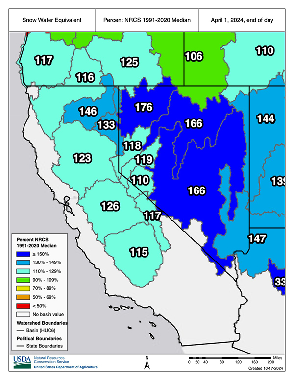
Figure 6: Summer Evaporative Demand
Key Takeaway: Summer evaporative demand reached record highs in California, especially during July, drying out the landscape.
California-Nevada Drought Impacts
- The state of Nevada total reservoir storage is 60% of capacity and 182% the median (Figure 7).
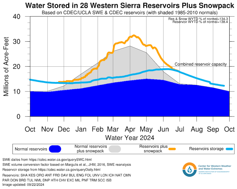
- Reservoir storage in the Western Sierra Nevada is about 135% of normal (Figure 8). California reservoir levels are primarily above historical averages.
- Upper Colorado River Basin precipitation and snowpack conditions are near normal. Lake Powell and Lake Mead storage levels are similar to last year, with Powell 39% full and Mead 33% full.
- Nevada had 826 fires as of October 14, 2024 —218 more fires than the 2012–2023 mean, but with 265,000 fewer acres burned than the mean.
- California had 170 more fires than the 5-year mean, but 272,000 fewer acres burned than the mean.
Figure 7: Reservoir Storage in Nevada
Key Takeaway: Nevada’s end of water year total reservoir storage capacity is 182% of the median.
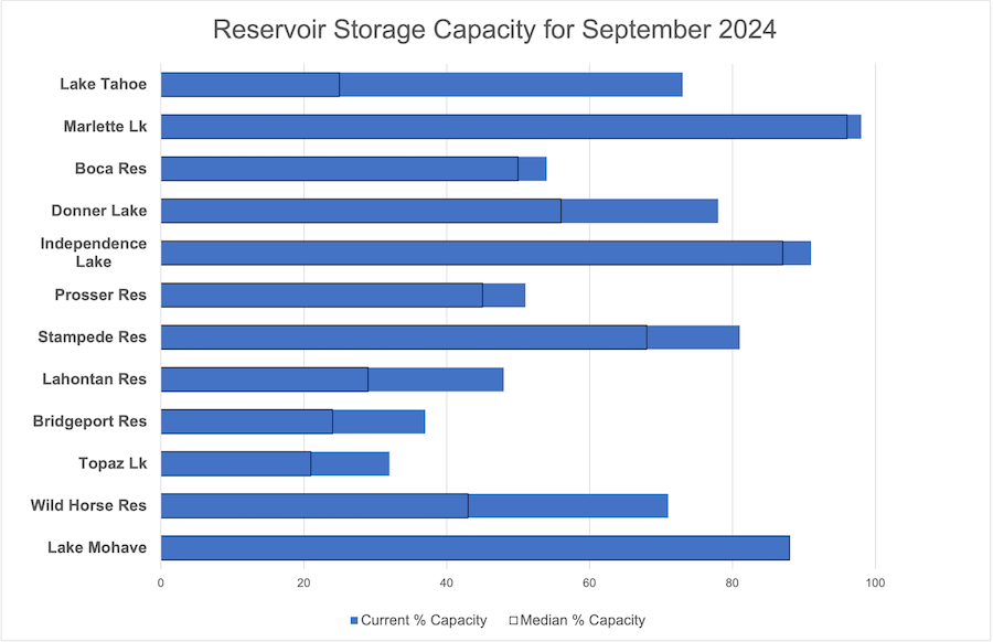
Figure 8: Water Stored in Western Sierra Reservoirs Plus Snowpack
Key Takeaway: As of the end of September 2024, the Western Sierra reservoir storage was about 135% above normal.
Outlooks and Forecasts for California-Nevada
- The Climate Prediction Center’s seasonal outlooks (November–January) show equal chances of above-, near-, or below-normal precipitation for most of the region (Figure 9).
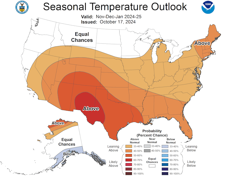
- The seasonal outlooks show 33%–50% chance of above-normal temperatures over much of California and Nevada from November–January, except for northern California, which has equal chances of above-, near-, or below-normal temperatures (Figure 10).
- Existing drought is forecast to persist over the next month and beyond.
- Above-normal significant wildland fire potential is expected to persist along the southern California coast through December.
- The El Niño–Southern Oscillation (ENSO) is currently neutral. A La Niña watch is in place.
- If La Niña emerges, it is likely to be a weaker event.
- Historically, La Niña winters tend to be warmer and drier in southern California-Nevada. However, every ENSO event is different and weather events, such as atmospheric rivers, can disrupt the traditional seasonal ENSO precipitation patterns.
- For more information, check out the NOAA ENSO blog.
Figure 9: Seasonal (3-Month) Precipitation Outlook
Key Takeaway: The NOAA National Weather Service’s Climate Prediction Center’s seasonal outlook favors equal chances of above-, below-, and near-normal precipitation for most of the region through the end of January 2025.
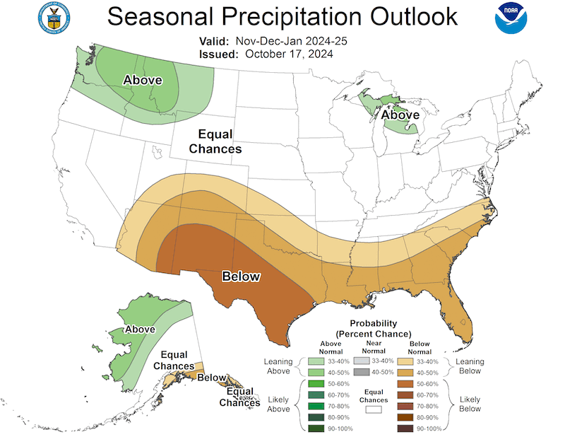
Figure 10: Seasonal (3-Month) Temperature Outlook
Key Takeaway: The NOAA National Weather Service’s Climate Prediction Center’s seasonal outlook favors above-normal temperatures for much of California-Nevada through January.
Resources
Explore regional and state drought information:
Register for the December 2 California-Nevada Drought and Climate Outlook Webinar, which will provide an overview of climate and drought conditions, impacts, and outlooks.
Prepared By
Amanda Sheffield
NOAA/NIDIS California-Nevada DEWS Regional Drought Information Coordinator, Cooperative Institute for Research in Environmental Sciences (CIRES)
Julie Kalansky
Principal Investigator California-Nevada Adaptation Program (a NOAA CAP team)
This Drought Status Update is issued in partnership between the National Oceanic and Atmospheric Administration (NOAA) and the California-Nevada Adaptation Program (a NOAA CAP team), Center for Western Weather and Water Extremes at Scripps Institution of Oceanography, UCS San Diego, and the Western Regional Climate Center at the Desert Research Institute to communicate a potential area of concern for drought expansion and/or development within the California-Nevada DEWS region based on recent conditions and the upcoming forecast. NIDIS and its partners will issue future Drought Status Updates as conditions evolve.
