Drought Continues to Impact Missouri River Basin, Especially Across Kansas and Nebraska
Key Points
- Despite some areas of improvement over the past few months, drought remains widespread across many of the states within the Missouri River Basin. Currently, 48% of this region is in drought, with the most intense areas in Kansas and Nebraska. 36% of Kansas is in the most intense level of drought, exceptional drought (D4), which is higher than any other state in the U.S. Areas with the most improvement in drought conditions over the last two months include northern Montana and eastern Kansas.
- Many areas within the Basin have received near- to above-normal snowfall this winter, and significant snowpack remains on the ground. Hopefully the above-normal snowfall season will have a positive impact on streamflow and soil moisture; however, the extent of this impact cannot be determined until the snow melts and the ground thaws for the season.
- The most intense areas of drought in Kansas and Nebraska are feeling ongoing impacts. Streamflow is below normal across both states, some groundwater levels have decreased in western Kansas, winter wheat and pasture conditions are suffering, and there has been increased wind erosion and dust storms.
- Because spring and early summer is typically the wettest time of the year for the region, the seasonal drought outlook shows the chance for improved drought conditions, with the possibility for drought removal, in some areas. However, drought is expected to persist in some of the worst areas in the Basin—western Kansas and eastern Colorado.
- With limited soil moisture across many areas in the Basin at the end of fall 2022, there are concerns that despite the above-normal winter rainfall and snowfall in some areas, soils will still be dry going into the 2023 growing season, or could quickly reverse from moist to dry with increased heat and vegetation growth.
The U.S. Drought Monitor (USDM) is updated each Thursday to show the location and intensity of drought across the country. This map shows drought conditions across the Missouri River Basin and surrounding areas using a five-category system, from Abnormally Dry (D0) conditions to Exceptional Drought (D4). The USDM is a joint effort of the National Drought Mitigation Center, U.S. Department of Agriculture, and National Oceanic and Atmospheric Administration. Learn more.
U.S. Drought Monitor Categories
Abnormally Dry (D0)
Abnormally Dry (D0) indicates a region that is going into or coming out of drought. View typical impacts by state.
Moderate Drought (D1)
Moderate Drought (D1) is the first of four drought categories (D1–D4), according to the U.S. Drought Monitor. View typical impacts by state.
Severe Drought (D2)
Severe Drought (D2) is the second of four drought categories (D1–D4), according to the U.S. Drought Monitor. View typical impacts by state.
Extreme Drought (D3)
Extreme Drought (D3) is the third of four drought categories (D1–D4), according to the U.S. Drought Monitor. View typical impacts by state.
Exceptional Drought (D4)
Exceptional Drought (D4) is the most intense drought category, according to the U.S. Drought Monitor. View typical impacts by state.
The U.S. Drought Monitor (USDM) is updated each Thursday to show the location and intensity of drought across the country. This map shows drought conditions across the Missouri River Basin and surrounding areas using a five-category system, from Abnormally Dry (D0) conditions to Exceptional Drought (D4). The USDM is a joint effort of the National Drought Mitigation Center, U.S. Department of Agriculture, and National Oceanic and Atmospheric Administration. Learn more.
Current Conditions and Impacts
Current Conditions
- Despite some improvement over the past few months, drought remains widespread across many of the states within the Missouri River Basin. Currently, 48% of this region is in drought, with the most intense areas in Kansas and Nebraska.
- 36% of Kansas is in the most intense level of drought, exceptional drought (D4), which is higher than any other state in the U.S. Overall, moderate to exceptional drought (D1–D4) covers 75% of Kansas. In Nebraska, almost 100% of the state is in drought, with 20% in moderate drought (D1), 45% in severe drought (D2), 29% in extreme drought (D3), and 5% in exceptional drought (D4).
- Drought has improved in portions of the Missouri River Basin over the past two months, most prominently across northern Montana, eastern Kansas, northeast Nebraska, southeast South Dakota, and portions of North Dakota and Wyoming (Figure 1).
- This relief came from near- to above-normal precipitation across these areas since late January. However, most of Kansas and Nebraska noticeably missed this winter precipitation (Figure 2).
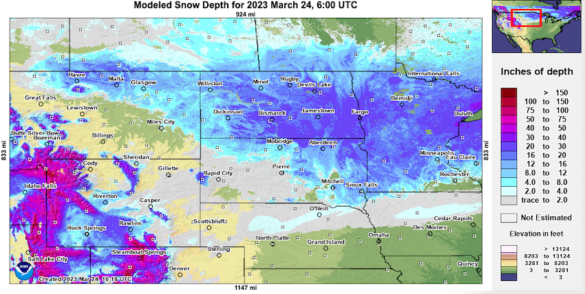
- Many areas within the Missouri River Basin have received near- to above-normal snowfall this winter (Figure 3), and significant snowpack remains on the ground (Figure 4). Hopefully this above-normal snowfall season will have a positive impact on streamflow and soil moisture; however, the extent of this impact cannot be determined until the snow melts and the ground thaws for the season.
Figure 1. U.S. Drought Monitor 8-Week Change Map
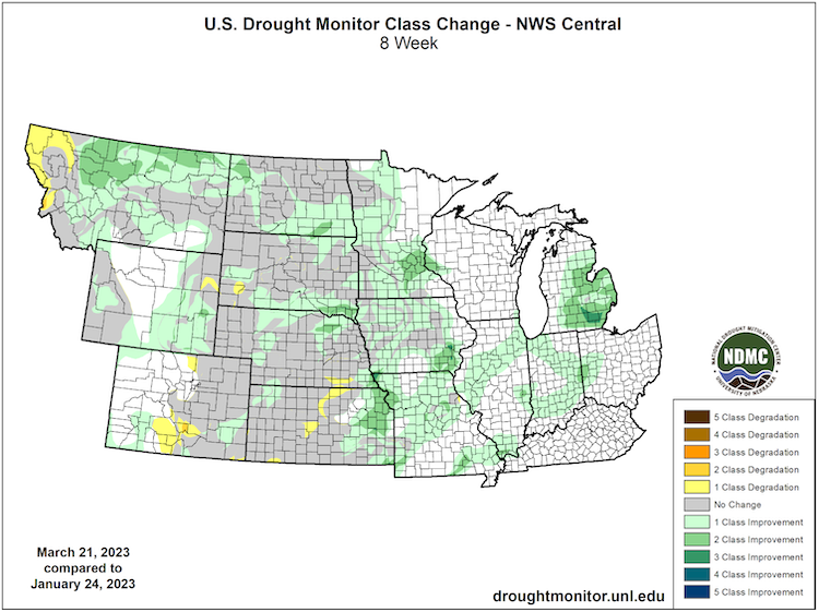
Figure 2. 60-Day Percent of Normal Precipitation (January 22–March 22, 2023)
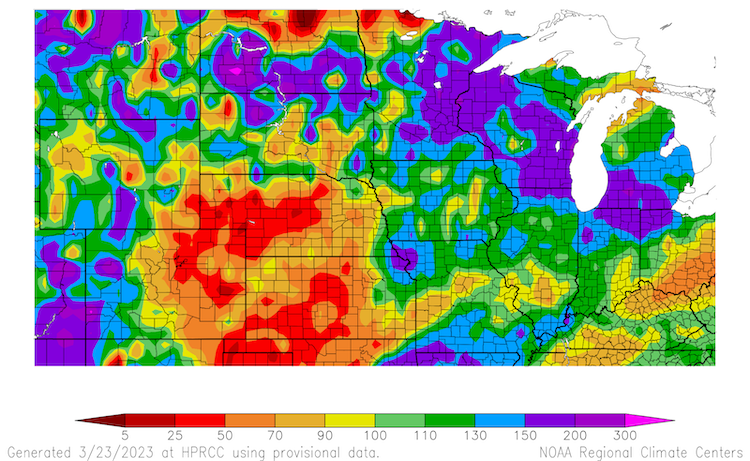
Figure 3. Departure from Average Snowfall (inches) (October 1, 2022–March 23, 2023)
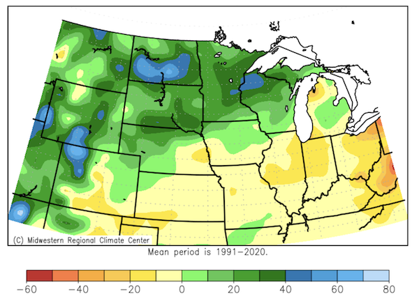
Figure 4. Modeled Snow Depth as of March 24, 2023
Drought Impacts
- The most intense areas of drought in Kansas and Nebraska are feeling ongoing impacts. Further north, drought impacts are more limited this time of year, as much of the ground is still frozen. The frozen ground limits drought recovery as the winter precipitation cannot soak into the ground.
- Streamflow is below normal across much of Kansas and southern Nebraska (Figure 5). Streams are likely lower in the northern states as well, but streamgages are not operating currently because of frozen conditions.
- Drought is also impacting groundwater levels across south central and western Kansas. The groundwater level fell by nearly three feet near Garden City, Liberal, and Ulysses, Kansas in January alone.
- A Condition Monitoring Observer Report (CMOR) from northern South Dakota (Ziebach County) on March 21 indicates that a widespread area has very low stock ponds, dry streambeds despite melting snow, and low enough water levels that cattle and wild animals can easily cross.
- February 2023 runoff into the Missouri River above Sioux City remains below normal at only 86% of average, according to the U.S. Army Corps of Engineers. Despite the low runoff totals and ongoing water conservation measures, enough water remains in the river for water supply needs.
- Kansas’ hard red wheat has struggled amid dry conditions this winter. As of mid-February, the crop was dormant and some wheat in western Kansas had not yet germinated for lack of moisture. According to the USDA, 50% of winter wheat in Kansas is rated as poor to very poor.
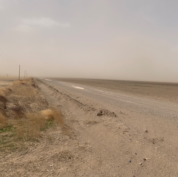
- Wind erosion and dust storms have been an issue in some areas. Western Kansas has reported issues with dust storms over the last couple of months, which causes air quality issues (Figure 6). In Blaine County, Montana, a CMOR report indicates that grasshopper infestation to native pasture and the lack of moisture is causing wind erosion.
- Poor pasture conditions and limited feed is reported in Kansas and Montana. In western Kansas, supplemental feed is required to maintain livestock condition, and many are struggling to find feed, with some electing to sell some animals to have fewer to feed. In Blaine County, Montana, grazing must be supplemented and water hauled for livestock. On the positive side, rangelands likely saw some recovery in the areas where drought conditions did improve this winter.
Figure 5. Real-Time Streamflow Percentiles for March 23, 2023
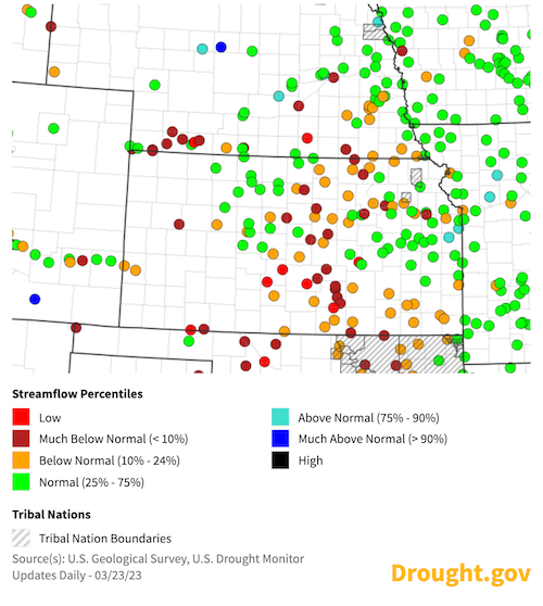
Figure 6. Dust Storm near Baca County (Colorado) and Morton County (Kansas) in Early March 2023
Outlook and Potential Impacts
- The 8–14 day outlook (March 31–April 6, 2023) shows the chance for below-normal precipitation in the central portion of the Missouri River Basin with near-normal conditions expected elsewhere (Figure 7).
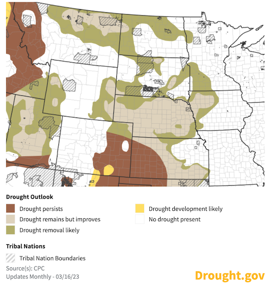
- The monthly (April 2023) and seasonal (April–June 2023) precipitation outlooks show equal chances over the Basin for near-, below-, or above-normal precipitation. Because spring and early summer is typically the wettest time of the year for the region, the seasonal drought outlook shows the chance for improved drought conditions, with the possibility for drought removal, in some areas (Figure 8). However, drought is expected to persist in some of the worst areas in the Basin—western Kansas and eastern Colorado.
- The U.S. Army Corps of Engineers 2023 calendar year runoff forecast above Sioux City is for 84% of average, which is based on current soil moisture conditions, plains and mountain snowpack, and long-term precipitation and temperature outlooks.
- With limited soil moisture across many areas in the Basin at the end of fall 2022, there are concerns that despite the above-normal winter rainfall and snowfall in some areas, soils will still be dry going into the 2023 growing season, or could quickly reverse from moist to dry rapidly with increased heat and vegetation growth.
Figure 7. 8–14 Day Precipitation Outlook (Valid March 31–April 6, 2023)
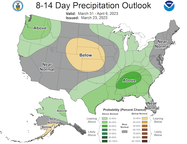
Figure 8. U.S. Seasonal Drought Outlook for March 16–June 30, 2023
For More Information
- NIDIS and its partners will issue future updates as conditions evolve.
- A special thank you to the state climate offices in the Missouri River Basin for providing local information on drought conditions and impacts included in the webinar and on this report.
- More local information is available from the following resources:
- To report or view local drought impact information:
- Report your Drought Impacts through Condition Monitoring Observer Reports (CMOR)
- To view or submit reports in Montana, visit the Montana Drought Impact Reporter.
- View CoCoRaHS Condition Monitoring reports.
- The upcoming North Central U.S. Climate and Drought Summary & Outlook Webinar on April 20, 2023 will offer updated information about conditions, impacts, and outlooks.
Prepared By
Molly Woloszyn
NOAA/National Integrated Drought Information System (NIDIS), CIRES/CU Boulder
Doug Kluck
NOAA/National Centers for Environmental Information
Dannele Peck & Dennis Todey
USDA Northern Plains Climate Hub and Midwest Climate Hub
Kevin Low
NOAA/Missouri Basin River Forecast Center
Audra Bruschi
NOAA/National Weather Service Central Region
Rezaul Mahmood & Gannon Rush
High Plains Regional Climate Center
This drought status update is issued in partnership between the National Oceanic and Atmospheric Administration (NOAA) and the U.S. Department of Agriculture (USDA) to communicate a potential area of concern for drought expansion and/or development within the Missouri River Basin based on recent conditions and the upcoming forecast. NIDIS and its partners will issue future drought status updates as conditions evolve.


