A Look Back at Drought in the Southern Plains in 2024
Key Points
- Exceptional Drought (D4) is present over the Big Bend region of the Rio Grande in western Texas.
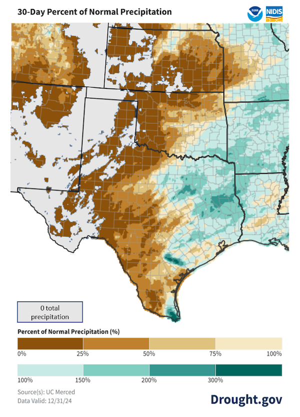
- Much of the High Plains received 0.0 inches of precipitation in December. This is rare but not unprecedented, and was a welcome change following a very wet November.
- 2024 ended with about the same amount of drought as it began with, but different regions are affected now than a year ago.
- Preliminary analysis shows 2024 was likely the warmest year on record for both Texas and Oklahoma, the 2nd warmest for Louisiana, and the 3rd warmest for Arkansas .
- Wildland fire potential is increased for most of Texas for January through March.
- Seasonal outlooks show increased odds of low precipitation and above-normal temperatures through March.
This U.S. Drought Monitor 52-week change map shows where drought has improved, remained the same, or worsened during 2024. Yellow/orange hues show areas where drought worsened, while green hues show drought improvement.
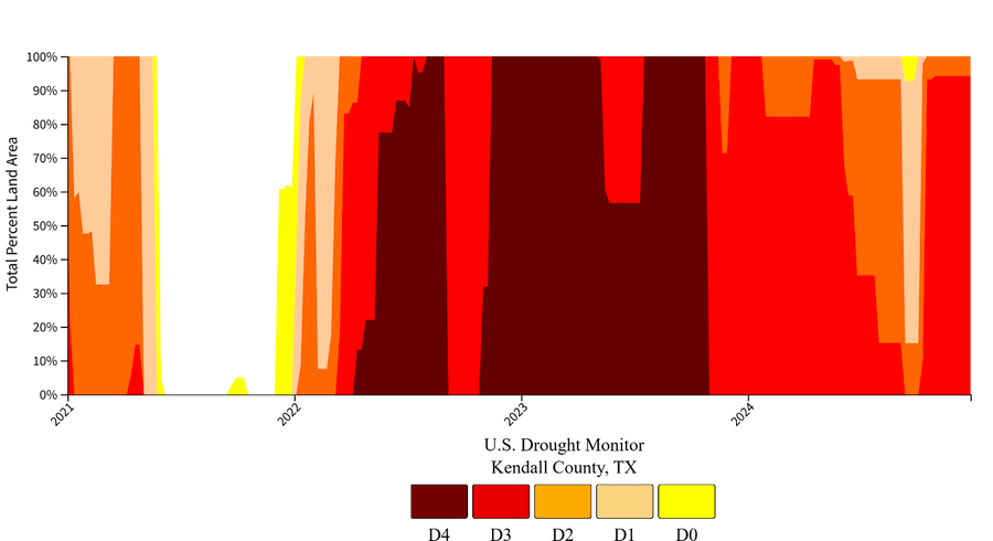
Key Takeaway: Drought in the Southern Plains states of Kansas, Oklahoma, and Texas was ever-present in 2024, but the areas in the most severe drought shifted over the course of the year. In Texas, the year began with Exceptional Drought (D4) along the Sabine River and ended with Exceptional Drought (D4) in the Big Bend region of the Rio Grande. One exception to the transient -drought is the Texas Hill Country, which saw drought all year long—the continuation of a multi-year drought that began in 2021—and ongoing drought impacts.
A drought index combines multiple drought indicators (e.g., precipitation, temperature, soil moisture) to depict drought conditions. For some products, like the U.S. Drought Monitor, authors combine their analysis of drought indicators with input from local observers. Other drought indices, like the Standardized Precipitation Index (SPI), use an objective calculation to describe the severity, location, timing, and/or duration of drought.
Learn MorePeriods of drought can lead to inadequate water supply, threatening the health, safety, and welfare of communities. Streamflow, groundwater, reservoir, and snowpack data are key to monitoring and forecasting water supply.
Learn MoreDrought can reduce the water availability and water quality necessary for productive farms, ranches, and grazing lands, resulting in significant negative direct and indirect economic impacts to the agricultural sector. Monitoring agricultural drought typically focuses on examining levels of precipitation, evaporative demand, soil moisture, and surface/groundwater quantity and quality.
Learn MoreDrought Degradation
5-Category Degradation
Drought/dryness has worsened by 5 categories, according to the U.S. Drought Monitor.
4-Category Degradation
Drought/dryness has worsened by 4 categories, according to the U.S. Drought Monitor.
3-Category Degradation
Drought/dryness has worsened by 3 categories, according to the U.S. Drought Monitor.
2-Category Degradation
Drought/dryness has worsened by 2 categories, according to the U.S. Drought Monitor.
1-Category Degradation
Drought/dryness has worsened by 1 category, according to the U.S. Drought Monitor.
Drought Improvement
1-Category Improvement
Drought/dryness has improved by 1 category, according to the U.S. Drought Monitor.
2-Category Improvement
Drought/dryness has improved by 2 categories, according to the U.S. Drought Monitor.
3-Category Improvement
Drought/dryness has improved by 3 categories, according to the U.S. Drought Monitor.
4-Category Improvement
Drought/dryness has improved by 4 categories, according to the U.S. Drought Monitor.
5-Category Improvement
Drought/dryness has improved by 5 categories, according to the U.S. Drought Monitor.
This U.S. Drought Monitor 52-week change map shows where drought has improved, remained the same, or worsened during 2024. Yellow/orange hues show areas where drought worsened, while green hues show drought improvement.
Key Takeaway: Drought in the Southern Plains states of Kansas, Oklahoma, and Texas was ever-present in 2024, but the areas in the most severe drought shifted over the course of the year. In Texas, the year began with Exceptional Drought (D4) along the Sabine River and ended with Exceptional Drought (D4) in the Big Bend region of the Rio Grande. One exception to the transient -drought is the Texas Hill Country, which saw drought all year long—the continuation of a multi-year drought that began in 2021—and ongoing drought impacts.
U.S. Drought Monitor change maps are released every Thursday morning, with data valid through Tuesday at 7 a.m. Eastern.
A drought index combines multiple drought indicators (e.g., precipitation, temperature, soil moisture) to depict drought conditions. For some products, like the U.S. Drought Monitor, authors combine their analysis of drought indicators with input from local observers. Other drought indices, like the Standardized Precipitation Index (SPI), use an objective calculation to describe the severity, location, timing, and/or duration of drought.
Learn MorePeriods of drought can lead to inadequate water supply, threatening the health, safety, and welfare of communities. Streamflow, groundwater, reservoir, and snowpack data are key to monitoring and forecasting water supply.
Learn MoreDrought can reduce the water availability and water quality necessary for productive farms, ranches, and grazing lands, resulting in significant negative direct and indirect economic impacts to the agricultural sector. Monitoring agricultural drought typically focuses on examining levels of precipitation, evaporative demand, soil moisture, and surface/groundwater quantity and quality.
Learn MoreCurrent Conditions for the Southern Plains
No Rain in the High Plains in December 2024
Winter is usually the driest season of the year for the High Plains. While December is not always the driest month of the year, a December with no measurable precipitation is not unprecedented. In fact:
- For places like Lubbock or Amarillo, Texas, or Goodland, Kansas, a totally dry December happens, on average, about once every 15 to 20 years. 2021 was the last time there was no precipitation in December.
- For most cities in the Texas and Oklahoma Panhandles, October 2024 was the last month to have no precipitation, and
- The longest bone-dry stretch on record was from November 2017 to January 2018 when several cities in the Texas and Oklahoma Panhandles, and southwest Kansas had between 0.0 and 0.02 inches of rain over three months.
Key Takeaway: Large parts of the High Plains received 0.0 inches of precipitation in December 2024. This came on the heels of a very wet November, and did not impact drought classification for this region.
A Look Back at Drought in the Southern Plains in 2024
Key Takeaway: Drought was present in the Southern Plains throughout 2024, but it shifted, waxed, and waned over the course of the year.
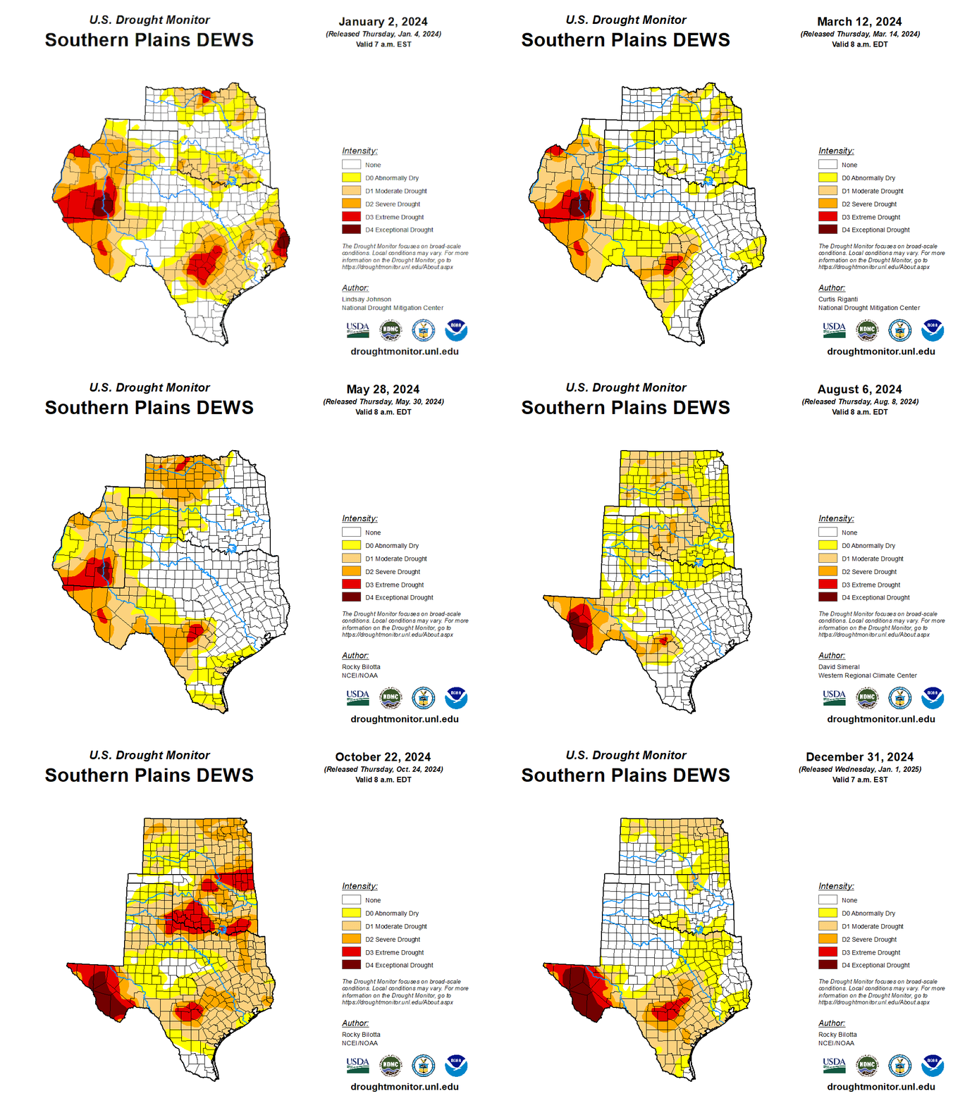
In January 2024 Moderate to Extreme Drought (D1–D3) lingered over the Texas Hill Country, but the most severe drought was along the Texas/Louisiana border and in southern New Mexico. At the end of 2023, 99% of Louisiana was in Moderate Drought (D1) and dealing with the aftermath of record-breaking wildfires. Carlsbad, New Mexico issued water restrictions. These droughts continued into January 2024. A very wet week in mid-January saw more than 5 inches of rain in eastern Texas and northern Louisiana. This improved, but did not eliminate, drought in the eastern half of the Southern Plains.
In April 2024, flash drought (i.e., rapid drought intensification) developed over northern Oklahoma and central Kansas. As a result, the U.S. Drought Monitor returned central Kansas to Extreme Drought (D3). The D3 drought lasted for only four weeks, but Severe Drought (D2) remained in Kansas for the rest of the year. Spring 2024 also saw areas along the Rio Grande Valley experiencing hydrologic drought, including extraordinary heat in May, with several locations setting maximum temperature records.
In late July and early August, very-much-above-average temperatures scorched the region and rapidly intensified drought conditions across parts of the Southern Plains. Hurricane Beryl made landfall near Houston on July 8, bringing heavy rain and flooding to eastern Texas, but missing the most drought-affected parts of the state. Extreme to Exceptional Drought (D3–D4) persisted or developed in Far West Texas.
Average to below-average rainfall in August in the Texas Hill Country was enough to improve, but not eliminate, a multi-year drought in that region. The U.S. Drought Monitors removed the Extreme Drought (D3) in Kendall County, Texas, in early September, ending a streak for that county that lasted 129 weeks. This reprieve was short-lived, however, as Kendall County returned to Extreme Drought (D3) only four weeks later, according to the October 8 U.S. Drought Monitor. In late September, some rain showers did little to improve drought conditions that developed across Oklahoma.
In October, low precipitation totals and unseasonably high temperatures led to rapid drought development over eastern Texas, Oklahoma, and Kansas, as well as Arkansas and Louisiana. Parts of eastern Texas that had experienced flood conditions in early summer saw drought develop only three months later.
Outlooks and Potential Impacts for the Southern Plains
- The National Weather Service Climate Prediction Center’s latest monthly and seasonal climate outlooks show increased probabilities for a warmer and drier start to 2025 compared to normal for much of the Southern Plains.
- Potential impacts include increased wildland fire risk, poor winter wheat yield, and lower reservoir storage for spring.
- The El Niño–Southern Oscillation (ENSO) was officially neutral as of mid-December. A La Niña watch is in place.
- ENSO-neutral means neither El Niño nor La Niña is driving current weather patterns.
- A weak La Niña pattern could possibly develop in January (59% chance) and is expected to persist through March 2025.
- If La Niña develops, La Niña winters tend to be warmer and drier for Texas, Louisiana, and Oklahoma with a weaker influence in Kansas and Nebraska. La Niña winters also tend to be cooler and sometimes snowier for the far-northern Plains states.
January 2025 Temperature Outlook
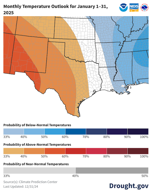
Key Takeaway: Despite unseasonably low temperatures for the first half of January, overall, odds favor above-normal temperatures for the western portion of the Southern Plains for the month.
January 2025 Precipitation Outlook
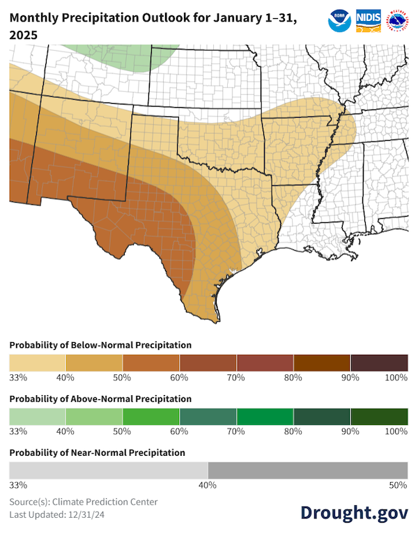
Key Takeaway: In January, the Climate Prediction Center’s outlook favors below-normal precipitation (33%–60% chance) for Texas and Oklahoma. January is usually one of the driest months for the High Plains, with precipitation averages ranging from 0.1 to 0.5 inches for the month.
Seasonal (3-Month) Temperature Outlook: January–March 2025
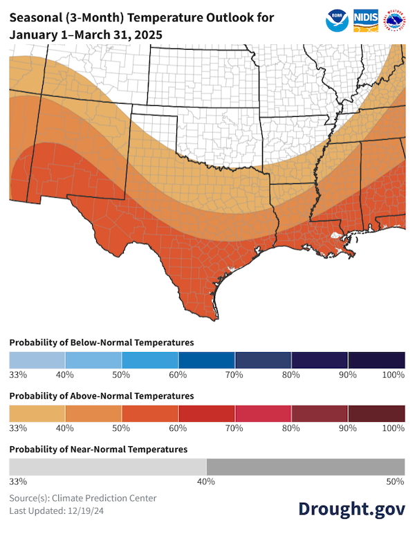
Key Takeaway: The first three months of 2025 are likely to be warmer than normal for Texas, with equal chances of above or below normal temperatures for Oklahoma and Kansas. The highest odds for warmer-than-normal temperatures are in southern Texas where there is a 50%–60% chance of above-normal temperatures.
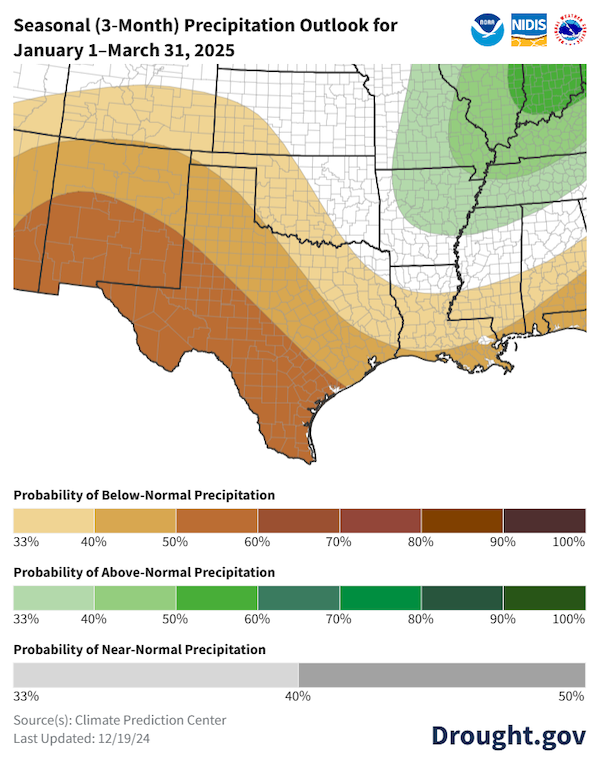
Seasonal (3-Month) Precipitation Outlook: January–March 2025
Key Takeaway: The latest seasonal precipitation outlook for January–March slightly favors lower-than-normal precipitation for southwestern Kansas and western Oklahoma. Odds increase to 50%–60% chance of a drier season over most of Texas, with the highest odds in the south. When considering statewide averages, January is usually the driest month of the year for Kansas and Oklahoma, while February is usually the driest month of the year for Texas.
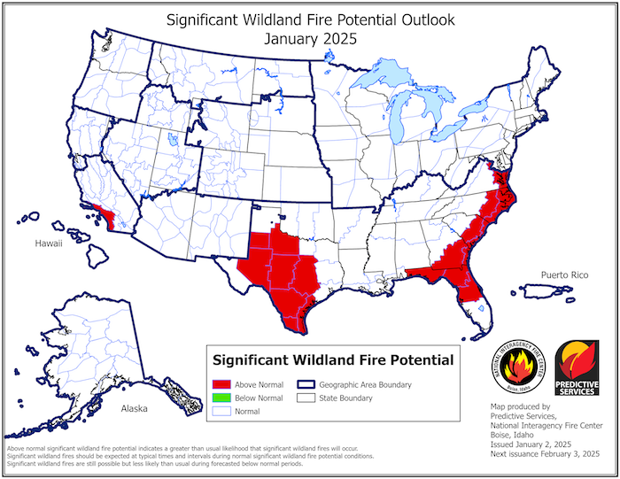
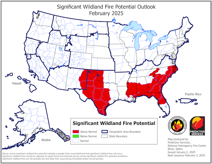
Significant Wildland Fire Potential Outlook for January and February 2025
Key Takeaway: There is significant wildland fire potential across Texas in January. Outlooks for February and March show increased wildland fire potential for Texas, western Oklahoma, and eastern New Mexico.
Southern Plains Drought Resources
Regional Resources
- Register for upcoming webinars:
- The February Southern Plains Climate and Drought Webinar on February 24, 2025, 11:00 am CT Southern Regional Climate Center
- Water Data for Texas
- Oklahoma Mesonet
- National Weather Service Drought Information Statements
- Explore state drought information on Drought.gov:
Prepared By
Joel Lisonbee, Adam Lang, Kelsey Eigsti, and Eleanor Hasenbeck
Cooperative Institute for Research in Environmental Sciences/University of Colorado, Boulder and NOAA’s National Integrated Drought Information System, Southern Plains Drought Early Warning System
John Nielsen-Gammon and BJ Baule
Texas State Climate Office, Texas State Climate Office, Texas A&M University
Southern Regional Climate Center
Chip Redmond and Matt Sittel
Kansas State Climate Office, Kansas State University
This Drought Status Update is issued in partnership between the National Oceanic and Atmospheric Administration (NOAA) and the State Climate Offices in Kansas, Oklahoma and Texas to communicate a potential area of concern for drought expansion and/or development within the Southern Plains region based on recent conditions and the upcoming forecast. NIDIS and its partners will issue future Drought Status Updates as conditions evolve.


