Day 3-7 U.S. Hazards Outlook
NOAA / National Weather Service / National Centers for Environmental Prediction / Weather Prediction Center (WPC)
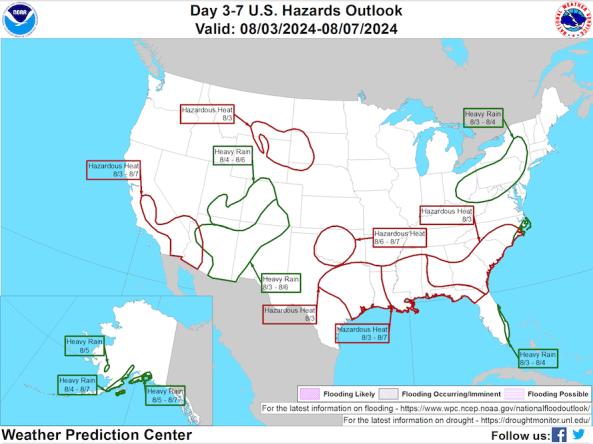
The National Weather Service Weather Prediction Center (WPC) U.S. Hazards Outlook depicts possible impending weather-related hazards during day 3–7 forecast period. The map is released every weekday afternoon and includes hazard risk areas related to precipitation/flooding, temperature, wildfire/winds, and soils/drought.
The hazard outlook map is accompanied by a narrative discussion, which describes the meteorological features that are associated with the depicted hazards. The hazard areas are based off of products issued from the WPC, the Storm Prediction Center (SPC), and the Climate Prediction Center (CPC), along with medium-range numerical model guidance. The intended audience includes emergency managers, weather forecasters, planners and managers in the public and private sectors, as well as the general public.
National Weather Service forecasters use set criteria for designating a hazard area as a starting point. However, often actual considerations for the outlook are based on subjective criteria, such as time of year, deviation from normal, or expected impacts.
How to
How do I use the site?
- Use the checkboxes above the interactive map to select hazard types to display: temperature, precipitation, wildfire, and soils.
- Click the colored regions on the interactive map to view more information about each hazard.
- Users can also view a static map image of the Day 3–7 U.S. Hazards Outlook by clicking the link below the interactive map.
- Below these maps, users can find links to the Extended Forecast Discussions for the continental U.S., Alaska, and Hawaii, which include a detailed summary of the current U.S. Hazards Outlook.
Access
U.S. Day 3–7 Hazards Outlook: View the hazard outlooks, download data, and view detailed summary of the outlook.
Static Hazards Map Image: View the current Day 3–7 Hazards Outlook as a static image.
Extended Forecast Discussion (CONUS): The "Weather/Hazards Highlights" section contains more information about hazards affecting the continental U.S.
Web Services for NWS Weather Hazards: View web services information for the NWS Day 3–7 and Day 8–14 Hazard Outlooks, including hazard criteria and data downloads.
Data Downloads:
- Download shapefiles:
- Download KML:

