Mixed Hydrological Signals Hold Most of the Region in Status Quo—But Teetering Toward Dryness
Key Points:
- Abnormally Dry (D0) conditions took hold in northern Maine last week, but recent rain kept conditions from expanding and deteriorating.
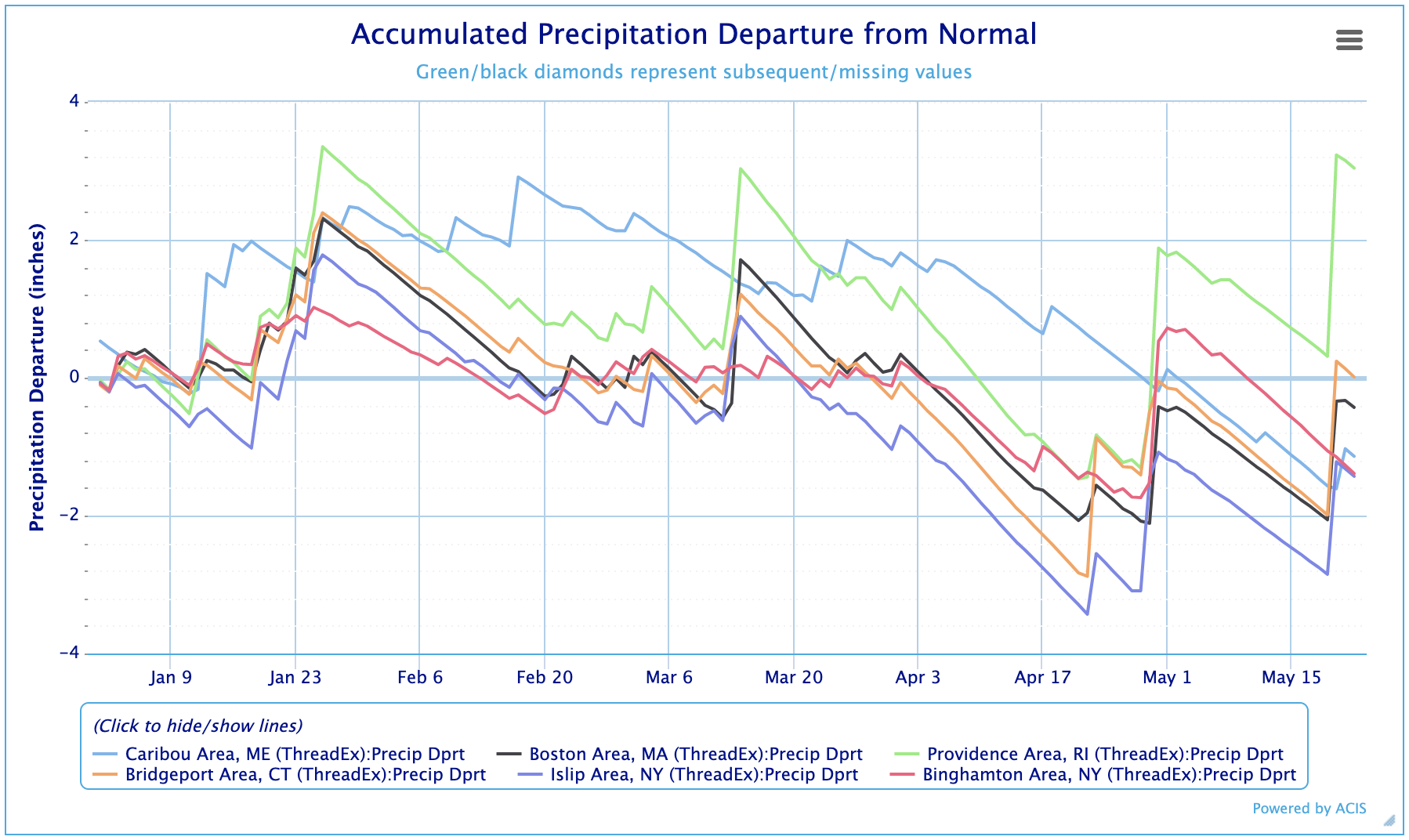
- This past week’s precipitation was balanced by earlier periods of drier and windier conditions, promoting a drought “holding pattern” for most of New England and New York.
- The cold dry air, responsible for freezing conditions last week, damaged some crops in New York, Massachusetts, New Hampshire, and Vermont and raised concerns for farmers about the increased variability of the weather and changing climate.
- Wildland fires, reported in both Massachusetts and New York, also reflected our region’s windy and dry periods over the past month.
Current U.S. Drought Monitor map for the Northeast Drought Early Warning System (DEWS) with data valid for May 16, 2023. The U.S. Drought Monitor is updated each Thursday to show the location and intensity of drought across the country.
According to the latest U.S. Drought Monitor, 22.87% of the Northeast is experiencing Abnormally Dry (D0) conditions.
Last week's U.S. Drought Monitor map for the Northeast Drought Early Warning System (DEWS) with data valid for May 9, 2023. The U.S. Drought Monitor is updated each Thursday to show the location and intensity of drought across the country.
As of May 9, 5.49% of the Northeast was experiencing Abnormally Dry (D0) conditions, compared to 22.87% on May 16.
U.S. Drought Monitor Categories
Abnormally Dry (D0)
Abnormally Dry (D0) indicates a region that is going into or coming out of drought. View typical impacts by state.
Moderate Drought (D1)
Moderate Drought (D1) is the first of four drought categories (D1–D4), according to the U.S. Drought Monitor. View typical impacts by state.
Severe Drought (D2)
Severe Drought (D2) is the second of four drought categories (D1–D4), according to the U.S. Drought Monitor. View typical impacts by state.
Extreme Drought (D3)
Extreme Drought (D3) is the third of four drought categories (D1–D4), according to the U.S. Drought Monitor. View typical impacts by state.
Exceptional Drought (D4)
Exceptional Drought (D4) is the most intense drought category, according to the U.S. Drought Monitor. View typical impacts by state.
Current U.S. Drought Monitor map for the Northeast Drought Early Warning System (DEWS) with data valid for May 16, 2023. The U.S. Drought Monitor is updated each Thursday to show the location and intensity of drought across the country.
According to the latest U.S. Drought Monitor, 22.87% of the Northeast is experiencing Abnormally Dry (D0) conditions.
Last week's U.S. Drought Monitor map for the Northeast Drought Early Warning System (DEWS) with data valid for May 9, 2023. The U.S. Drought Monitor is updated each Thursday to show the location and intensity of drought across the country.
As of May 9, 5.49% of the Northeast was experiencing Abnormally Dry (D0) conditions, compared to 22.87% on May 16.
The U.S. Drought Monitor map is updated weekly on Thursday mornings, with data valid through the previous Tuesday at 7 a.m. Eastern.
The U.S. Drought Monitor map is updated weekly on Thursday mornings, with data valid through the previous Tuesday at 7 a.m. Eastern.
Current Conditions
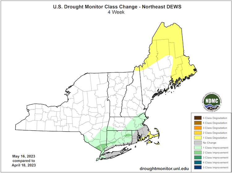
U.S. Drought Monitor 4-Week Change Map
Accumulated Precipitation Departure from Normal
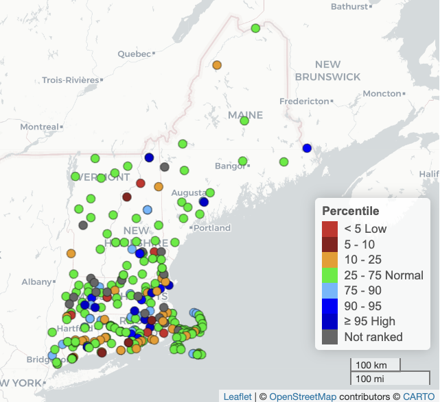
New England Groundwater Levels
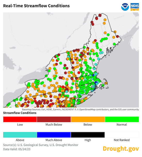
Real-Time Streamflow Conditions
State-Reported Conditions and Impacts
Connecticut
Maine
Massachusetts
- Massachusetts Drought Management Task Force
- Impacts:
- May 23, 2023: New England Public Media – Fruit Growers Assessing Crop Loss After Freeze
- May 17, 2023: Spectrum News – Last Year’s Drought Increasing This Year’s Fire Risk
- May 16, 2023: CBS Boston/MA DCR – Breakheart Reservation Brush Fire (YouTube Video)
- May 7, 2023: The Sun Chronicle – April Warm And Dry
- April 30, 2023: The Sun Chronicle – Attleboro Water Restrictions: All About Being Prepared for Dry Conditions
New Hampshire
- New Hampshire Department of Environmental Services: Drought
- Impacts:
- May 22, 2023: Keene Sentinel – Hard Freeze Causes Significant Crop Damage
New York
- New York State Department of Environmental Conservation (DEC): Drought
- Impacts:
- May 23,2023: NY State Department of Environmental Conservation – Forest Rangers Week In Review (Wildland Fires in Albany, Clinton, Schoharie and Sullivan Counties)
- May 18, 2023: Democrat & Chronicle – Frost Damages Central NY Grapevines
Rhode Island
- Rhode Island Water Resources Board: Drought Management Program
- Impacts:
- May 3, 2023: WUN – Some Drought History in Rhode Island
Vermont
- Vermont Agency of Natural Resources, Department of Environmental Conservation: Drought and Other Hazards
- Impacts:
- May 19, 2023: WCAX3 – Stowe, Beavers, Wetlands and Drought
- May 18, 2023: Vermont Public – VT Farmers Take Stock of Frost Damage
- May 10, 2023: Colchester Sun – Spongy Moth Management Update
Find additional impacts through the National Drought Mitigation Center’s Drought Impact Reporter.
Visit the new Drought.gov state pages for additional maps and resources. Or, find local drought information by address, city or zip code on Drought.gov.
Outlooks
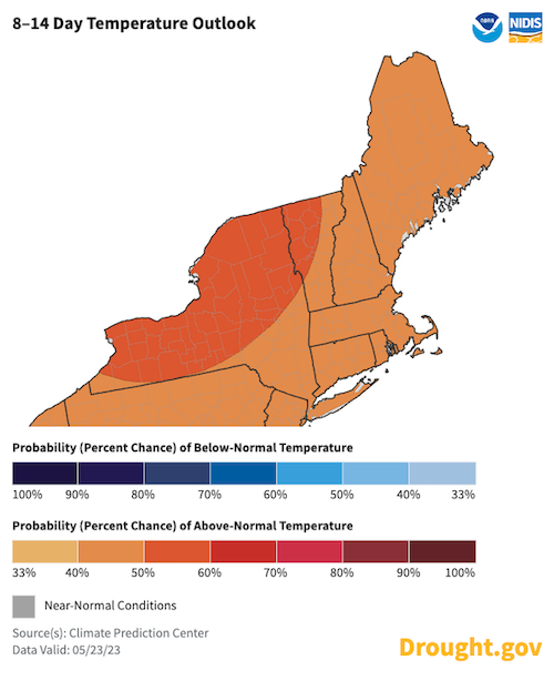
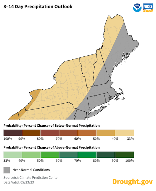
8–14 Day Temperature and Precipitation Outlooks: May 31–June 6
The 8–14 day outlooks show increased chances for above-normal temperatures across the entire region, and below-normal precipitation across much of Maine, Hew Hampshire, New York, and Vermont. This combination of conditions could be beneficial for spring planting but enhances evapotranspiration during the period.
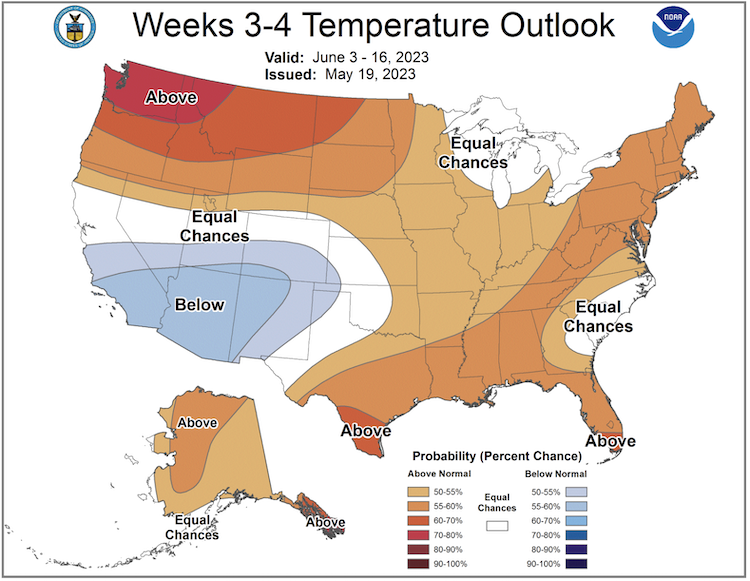
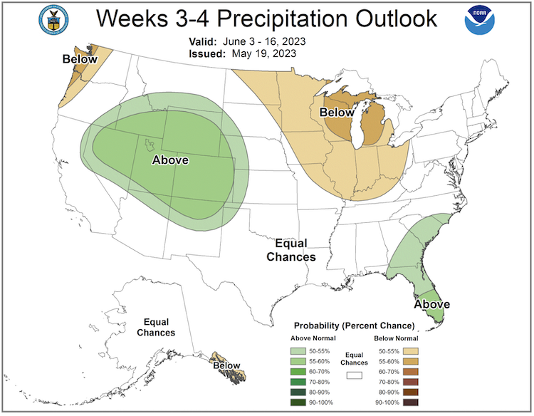
Week 3–4 Temperature and Precipitation Outlooks: June 3–16
The Climate Prediction Center's outlook for June 3–16, which favors above-normal temperatures for the Northeast, would support drying and the potential emergence of drought in June, particularly if precipitation is below or near normal.
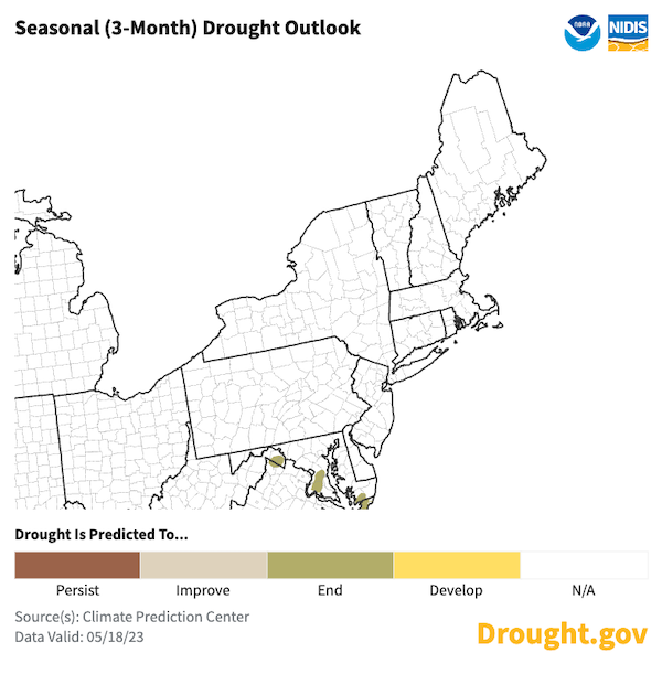
U.S. Seasonal Drought Outlook: May 18–August 31, 2023
The Climate Prediction Center's seasonal drought outlook indicates no strong influences for drought development in the Northeast during the period (May 18–August 31), but all eyes should be on the next update, which is scheduled for June 15, 2023.
Special Announcement
NIDIS Launches Improved and Expanded State Pages
Just in time to monitor changing conditions in the spring and summer months, the U.S. Drought Portal now offers new and improved state pages. The expanded Drought.gov state pages—which NIDIS developed in collaboration with NOAA’s National Centers for Environmental Information and state partners—provide a one-stop shop for state drought information, including interactive and easily shareable maps, statistics, and resources for all 50 states. Questions or feedback? Email us at drought.portal@noaa.gov.
Explore the new state pages for the Northeast and Mid-Atlantic:
- Connecticut
- Delaware
- Maine
- Maryland
- Massachusetts
- New Hampshire
- New Jersey
- New York
- Pennsylvania
- Rhode Island
- Vermont
- West Virginia
What We Are Watching
- Video: Introducing the U.S. Geological Survey Flow Photo Explorer
- Featured research:
- Article in Environmental Research Letters: Multi-scale planning model for robust urban drought response, May 2023.
- Article in the Journal of Hydrology: Delayed response of groundwater to multi-year meteorological droughts in the absence of anthropogenic management, December 2021.
Featured Resources
- Flash Drought Monitoring Tools (PDF): From presentations during the 2021 Flash Drought Webinar Series, 2023 National Flash Drought Workshop, and subsequent discussions with subject matter experts, NIDIS developed this handout listing currently available flash drought-oriented prediction and monitoring tools.
- The Desert Research Institute (DRI) Aims to Increase Scientific Access to Earth Monitoring Data With Re-Launch of ClimateEngine.Org
- About the U.S. Drought Monitor:
- Video: Assessing Drought in the United States from CoCoRaHS
- Heat resources:
- Heat.gov: Access guides, infographics, and resources on heat and health from the National Integrated Heat Health Information System
- Heat.gov's Heat Awareness Social Media Campaign, May 15–19, 2023
- Video recording: National Weather Service Partner and Users Heat Webinar
Upcoming Events
- Register now for the National Soil Moisture Coordinating Network’s next quarterly webinar on May 25: USDA Perspectives on Monitoring and Assessing Drought Impacts and Fire Risk.
- This August, NIDIS will host the 2023 National Soil Moisture Workshop. View more information and register here.
Additional Resources
- Look back at previous Northeast DEWS Drought Status Updates
- Your local National Weather Service office
- NOAA Regional Climate Services Monthly Webinar Series (next webinar is on May 25)
- USDA Northeast Climate Hub
- USGS New England and New York Water Science Centers
Contacts for More Information
Sylvia Reeves
Regional Drought Information Coordinator (Northeast DEWS)
NOAA/CIRES/National Integrated Drought Information System (NIDIS)
Email: sylvia.reeves@noaa.gov
Ellen L. Mecray
Regional Climate Services Director, Eastern Region
NOAA/NESDIS/National Centers for Environmental Information
Email: Ellen.L.Mecray@noaa.gov
Prepared By
Sylvia Reeves
NOAA/National Integrated Drought Information System (NIDIS), CIRES
Samantha Borisoff, Jessica Spaccio, Keith Eggleston, Art DeGaetano, Natalie Umphlett
Northeast Regional Climate Center
Ellen Mecray
Regional Climate Services Director, Eastern Region, NOAA
Gardner Bent
USGS New England Water Science Center
In partnership with National Weather Service Offices of the Northeast and State Climate Offices of the Northeast.
This drought status update is issued in partnership between the National Oceanic and Atmospheric Administration (NOAA), U.S. Geological Survey, and the U.S. Department of Agriculture (USDA) to communicate concern for drought expansion and intensification within the Northeast U.S. based on recent conditions and the forecasts and outlooks. NIDIS and its partners will issue future drought status updates as conditions evolve.


