Forecasts Point to Rapid Onset Drought and Further Drought Deterioration
Key Points
- Low precipitation totals and unseasonably high temperatures led to rapid drought development over the past 30 days in eastern Texas, Oklahoma, and Kansas, as well as Arkansas and Louisiana. Parts of eastern Texas experienced flood conditions in early summer, but now expect drought to develop.
- Near-record or record-breaking temperatures and precipitation deficits defined September in North Dakota, South Dakota, Wyoming, and Nebraska. Near-term forecasts predict continued much-above-normal temperatures and absent precipitation. The forecasted conditions could lead to continued very high evaporative demand across the region, worsening drought conditions.
- The Climate Prediction Center’s 8–14 day outlooks show high probabilities for above-normal temperatures for the Great Plains from the Canadian border to the Gulf Coast.
- Precipitation forecasts show no precipitation for the Southern Plains and Missouri River Basin over the next week, and this is likely to continue through the next 10 days. The 8–14 day precipitation outlook shows mixed odds across the regions, but even normal rainfall in late October will leave a rainfall deficit in the region.
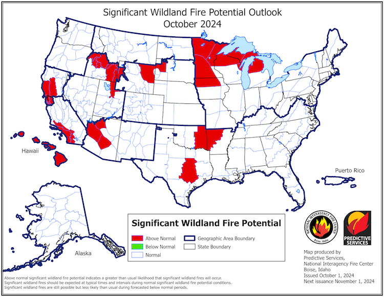
- Heightened fire risk is predicted for parts of Wyoming, South Dakota, Oklahoma, and Texas in October. Fire risk is expected to remain elevated for Texas and Oklahoma through the end of the year (November and December).
This update is based on data available as of Thursday, October 10, 2024 at 8:00 a.m. MT. We acknowledge that conditions are evolving.
8-14 day U.S. Hazards Outlook showing the risk of Rapid Onset Drought (flash drought) development in solid orange and places where ongoing drought may persist or worsen in stippled orange. Forecasters use initial conditions, like existing dryness (e.g., soil moisture), temperature, and precipitation outlooks, to assess the risk of rapid drought development.
Risk of much below normal temperatures is highlighted in the blue circle, with flooding risk in gray stripes.
Hazard Risk Areas
Risk of Rapid Onset Drought
National Weather Service forecasters predict that rapid drought development (also known as "flash drought") may occur in the coming weeks.
Risk of Much Below Normal Temperatures
National Weather Service forecasters predict a risk of much below normal temperatures over the next 8–14 days.
Risk of Flooding Possible
National Weather Service forecasters predict that flooding is possible over the next 8–14 days.
8-14 day U.S. Hazards Outlook showing the risk of Rapid Onset Drought (flash drought) development in solid orange and places where ongoing drought may persist or worsen in stippled orange. Forecasters use initial conditions, like existing dryness (e.g., soil moisture), temperature, and precipitation outlooks, to assess the risk of rapid drought development.
Risk of much below normal temperatures is highlighted in the blue circle, with flooding risk in gray stripes.
National Weather Service (NWS) forecasters issue Rapid Onset Drought risk areas on Thursdays, with the potential for updates on the following Mondays, from April 1–October 31.
Current Conditions and Impacts for the Missouri River Basin and Southern Plains
- Rapid drying will likely cause further drought deterioration and expansion across the Southern Plains and Missouri River Basin states, heighten fire risk, impact harvest, and continue to decrease runoff into the Missouri River, further lowering flows.
- In Oklahoma, winter wheat is already poor because soil moisture is so low. Many farmers chose not to plant, while others are dry planting in hopes of winter precipitation.
- Poor winter wheat conditions are expected to develop or continue in Texas, Oklahoma, and Kansas.
- Wildfires are active in northeast Oklahoma. The rest of the wildfire season is likely to be high risk in Oklahoma, especially in the panhandle, which received 6–10 inches of rain and had ample vegetation growth in July and August, followed by a warm and relatively dry September. This means there is more vegetation to provide fuel for wildfire, and that vegetation is drying, driving increased fire risk.
- Six Wyoming Counties received disaster declarations on October 1 due to damage and losses from wildfire. As of October 9, 603 fires have burned more than 760,000 acres in Wyoming.
- Numerous wildfires are active in North Dakota, with over 100,000 acres burned since Friday October 4, 2024. A wet spring and very dry September left fuel loads very dry. High fire risk is predicted throughout October.
- The following is the total number of weather stations (with a minimum of 30 years of data) throughout the central U.S. that set a new record for the hottest or driest September:
Number of Weather Stations with September Records (30+ Years of Data) | ||
State | Stations with Record-Breaking Heat | Stations with Record-Breaking Dryness |
Data source: Applied Climate Information System (ACIS).
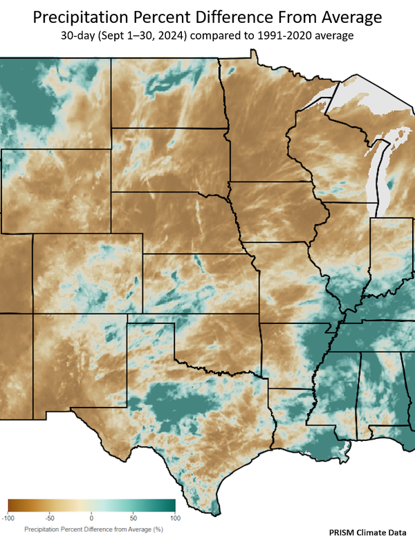
30-Day Percent of Average Precipitation: September 2024
Key Takeaway: For the month of September, which is usually the 4th wettest month of the year for eastern Oklahoma and eastern Texas, rainfall totals were very low. In the north central U.S., North Dakota, Nebraska, and Iowa experienced their driest September on record. Sioux Falls, South Dakota experienced its driest September on record.
Forecasts and Outlooks
- The National Weather Service Climate Prediction Center’s latest monthly and seasonal climate outlooks show increased probabilities for a warmer and drier end to 2024 compared to normal for most of the Southern Plains and Missouri River Basin.
- A warm and dry end to the year will worsen and expand drought.
- Potential impacts include increased wildland fire risk, poor winter wheat yield, and lower reservoir storage for spring.
- The El Niño–Southern Oscillation (ENSO) is currently neutral. A La Niña watch is in place.
- ENSO-neutral means neither El Niño nor La Niña is driving current weather patterns.
- A La Niña pattern is favored to develop in September–November (60% chance) and is expected to persist through January–March 2025.
- If La Niña develops, La Niña winters tend to be warmer and drier for Texas, Louisiana, and Oklahoma with a weaker influence in Kansas and Nebraska. La Niña winters also tend to be cooler and sometimes snowier for the far-northern Plains states.
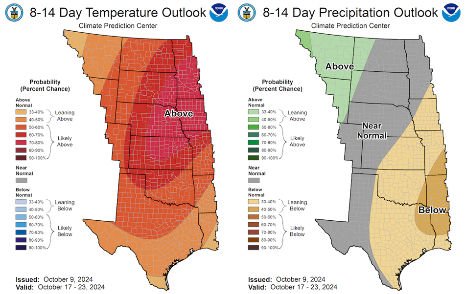
8-14 Day Outlooks for October 17–23, 2024
Key Takeaway: Odds strongly favor above-normal temperatures for most of the central U.S. in mid-October. Odds strongly favor below-normal precipitation for the eastern portions of the Southern Plains in mid-October, including regions that already received little-to-no rainfall over the past month.
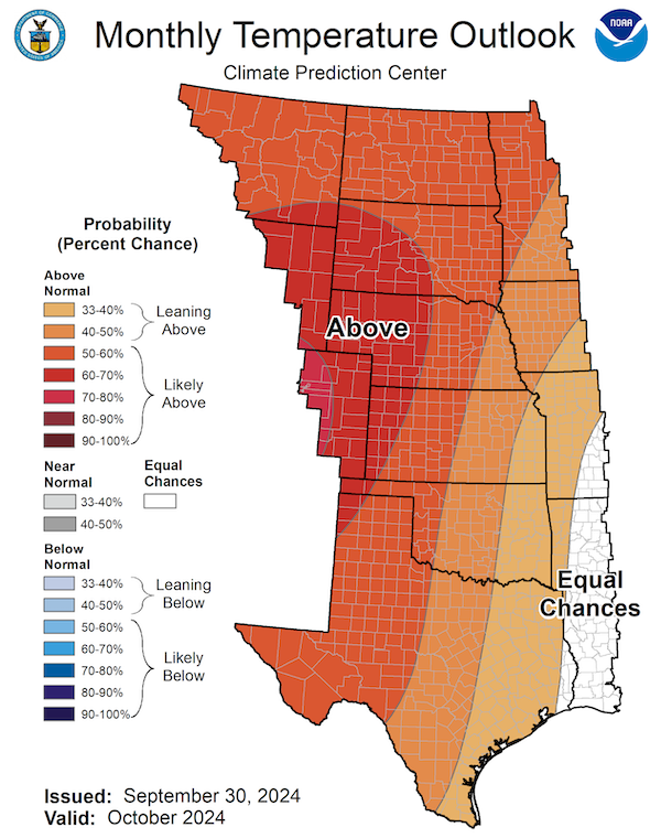
October 2024 Temperature Outlook
Key Takeaway: Odds favor above-normal temperatures for most of the central U.S. for October.
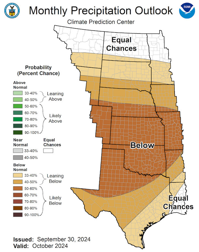
October 2024 Precipitation Outlook
Key Takeaway: In October, the Climate Prediction Center’s outlook favors (33%–60% chance) below-normal precipitation for most of the Southern Plains and Missouri River Basin. October is usually one of the wettest months for eastern Texas, with precipitation averages ranging from four to six inches for the month. October precipitation across the Southern Plains is usually reliable for reservoir refill, aquifer recharge, and priming the soil to plant winter wheat.
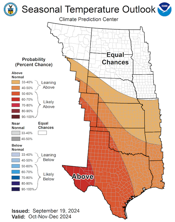
Seasonal (3-Month) Temperature Outlook: October–December 2024
Key Takeaway: The last three months of this year are likely to be warmer than normal. The highest odds for warmer-than-normal temperatures from October–December are in far west Texas where there is a 60%–70% chance of above-normal temperatures. The odds decline toward the northeast such that most of eastern Kansas has only a 33%–40% chance of exceeding normal temperatures for the season, and Iowa has an equal chance of above-, near-, or below-normal temperatures.
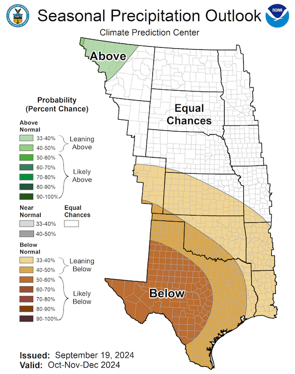
Seasonal (3-Month) Precipitation Outlook: October–December 2024
Key Takeaway: The latest seasonal precipitation outlook for October–December slightly favors lower-than-normal precipitation for Kansas and northeast Oklahoma with odds increasing to 40%–50% for the panhandle regions, southwest Oklahoma, and eastern Texas. Odds for a dry end to the year increase to 50%–60% for western Texas.
Significant Wildland Fire Potential Outlook for October 2024
Key takeaway: There is significant wildland fire potential in many states across the central U.S. Most of Minnesota has above-normal risk of significant wildland fire for October 2024. Parts of Wyoming, South Dakota, Iowa, Oklahoma, Arkansas, and Texas are also at elevated risk for significant wildland fire.
Resources
- Southern Regional Climate Center
- High Plains Regional Climate Center
- USDA Northern Plains Climate Hub
- Register for upcoming webinars:
- The North Central U.S. Climate and Drought Summary & Outlook Webinar on Thursday, October 17 at 1 p.m. CT/12 p.m. MT will provide an overview of climate and drought conditions, impacts, and outlooks in the North Central U.S..
- The Southern Plains Climate and Drought Update on Tuesday, October 22 at 1 p.m. CT will examine current conditions and the climate outlooks through winter in Texas, Oklahoma, and Kansas.
- The Wyoming Conditions Monitoring Team Conditions and Outlooks Webinar on Thursday, October 17 at 1 p.m. MT will present current climate conditions and outlooks along with a recap of Water Year 2024.
- The U.S. Drought Monitor Informational Webinar on Thursday, November 14 at 1 p.m. ET will explain the U.S. Drought Monitor, the process behind it, and how people can be part of it.
- More local information is available from the following resources:
- To report or view local drought impact information:
- Latest U.S. Army Corps of Engineers Update for the Missouri River Basin
Prepared By
Joel Lisonbee, Jason Gerlich, Molly Woloszyn, Adam Lang, Kelsey Satalino, and Eleanor Hasenbeck
Cooperative Institute for Research in Environmental Sciences/University of Colorado, Boulder and NOAA’s National Integrated Drought Information System
Gary McManus
Oklahoma State Climatologist, Oklahoma Mesonet, Oklahoma Climatological Survey
John Nielsen-Gammon
Texas State Climatologist, Texas State Climate Office, Texas A&M University
Southern Regional Climate Center
Antony R. Bergantino
Director Wyoming State Climate Office, Wyoming State Climate Office, University of Wyoming
Victor Murphy, Audra Bruschi
National Weather Service
Adam Hartman, Johnna Infanti, Brad Pugh
National Weather Service, Climate Prediction Center
Doug Kluck
NOAA/National Centers for Environmental Information
Rezaul Mahmood and Gannon Rush
High Plains Regional Climate Center/University of Nebraska
This drought status update is issued in partnership between the National Oceanic and Atmospheric Administration (NOAA) and partners across the Southern Plains and Missouri River Basin Drought Early Warning Systems to communicate a potential area of concern for drought expansion and/or development within the Southern Plains region based on recent conditions and the upcoming forecast. NIDIS and its partners will issue future drought status updates as conditions evolve.


