Drought Returns to New England’s Coastline as Abnormal Dryness Expands
Key Points
- Last week, Moderate Drought (D1) developed along the Maine, New Hampshire, and northern Massachusetts coastlines. Some Moderate Drought pushed into central New Hampshire almost to the Vermont border.
- Until its return last week, drought had been on hiatus since early August for much of the Northeast.
- Early last week, Abnormal Dryness (D0) surged from east to west across the central Connecticut River Valley and into portions of the Hudson River Valley of New York. Rainfall in the past few days trimmed that coverage on the western edge.
- In western New York, Abnormal Dryness (D0) returned in mid-September and has expanded in coverage over the last few weeks, especially along the New York border with western Pennsylvania.
- Severe Drought (D2) exists in portions of western Pennsylvania with Exceptional Drought (D4) present in Pennsylvania’s neighboring states of Ohio and West Virginia.
- In general, the Northeast received minimal rainfall from Helene with the bulk of that storm’s precipitation heavily impacting the southern U.S.
- The National Weather Service’s precipitation forecast for the coming week (October 3–10) predicts minimal rainfall in the Northeast, so “status quo” conditions could prevail with the expected below-normal temperatures.
See the Northeast Regional Climate Center blog for additional information.
The U.S. Drought Monitor depicts the location and intensity of drought across the country. The map uses 5 classifications: Abnormally Dry (D0), showing areas that may be going into or are coming out of drought, and four levels of drought (D1–D4).
The U.S. Drought Monitor is a joint effort of the National Oceanic and Atmospheric Administration, U.S. Department of Agriculture, and National Drought Mitigation Center.
A drought index combines multiple drought indicators (e.g., precipitation, temperature, soil moisture) to depict drought conditions. For some products, like the U.S. Drought Monitor, authors combine their analysis of drought indicators with input from local observers. Other drought indices, like the Standardized Precipitation Index (SPI), use an objective calculation to describe the severity, location, timing, and/or duration of drought.
Learn MorePeriods of drought can lead to inadequate water supply, threatening the health, safety, and welfare of communities. Streamflow, groundwater, reservoir, and snowpack data are key to monitoring and forecasting water supply.
Learn MoreDrought can reduce the water availability and water quality necessary for productive farms, ranches, and grazing lands, resulting in significant negative direct and indirect economic impacts to the agricultural sector. Monitoring agricultural drought typically focuses on examining levels of precipitation, evaporative demand, soil moisture, and surface/groundwater quantity and quality.
Learn MoreU.S. Drought Monitor Categories
D0 - Abnormally Dry
Abnormally Dry (D0) indicates a region that is going into or coming out of drought. View typical impacts by state.
D1 - Moderate Drought
Moderate Drought (D1) is the first of four drought categories (D1–D4), according to the U.S. Drought Monitor. View typical impacts by state.
D2 - Severe Drought
Severe Drought (D2) is the second of four drought categories (D1–D4), according to the U.S. Drought Monitor. View typical impacts by state.
D3 - Extreme Drought
Extreme Drought (D3) is the third of four drought categories (D1–D4), according to the U.S. Drought Monitor. View typical impacts by state.
D4 - Exceptional Drought
Exceptional Drought (D4) is the most intense drought category, according to the U.S. Drought Monitor. View typical impacts by state.
Total Area in Drought (D1–D4)
Percent area of the Northeast Drought Early Warning System that is currently in drought (D1–D4), according to the U.S. Drought Monitor.
The U.S. Drought Monitor depicts the location and intensity of drought across the country. The map uses 5 classifications: Abnormally Dry (D0), showing areas that may be going into or are coming out of drought, and four levels of drought (D1–D4).
The U.S. Drought Monitor is a joint effort of the National Oceanic and Atmospheric Administration, U.S. Department of Agriculture, and National Drought Mitigation Center.
This U.S. Drought Monitor is released every Thursday morning, with data valid through Tuesday at 7 a.m. ET.
A drought index combines multiple drought indicators (e.g., precipitation, temperature, soil moisture) to depict drought conditions. For some products, like the U.S. Drought Monitor, authors combine their analysis of drought indicators with input from local observers. Other drought indices, like the Standardized Precipitation Index (SPI), use an objective calculation to describe the severity, location, timing, and/or duration of drought.
Learn MorePeriods of drought can lead to inadequate water supply, threatening the health, safety, and welfare of communities. Streamflow, groundwater, reservoir, and snowpack data are key to monitoring and forecasting water supply.
Learn MoreDrought can reduce the water availability and water quality necessary for productive farms, ranches, and grazing lands, resulting in significant negative direct and indirect economic impacts to the agricultural sector. Monitoring agricultural drought typically focuses on examining levels of precipitation, evaporative demand, soil moisture, and surface/groundwater quantity and quality.
Learn MoreCurrent Conditions in the Northeast
- Moderate Drought (D1) returned to New England as the growing season is ending and drier conditions for most harvests are preferred. The cranberry harvest peaks in October and early November. Growers will need to monitor water availability.
- Locations that need to be monitored for degradation include Massachusetts, coastal New England, Long Island, and western New York. In some cities, accumulated precipitation departures from normal range from an inch up to 5 inches below normal.
- Fall foliage is progressing normally for most of the Northeast with peak color expected in the next few weeks. Communities with tourism and fall recreation–based economies should not be negatively impacted except in those areas where summer storms and flooding caused damage to trees, homes, hotels, and other infrastructure.
Figure 1. Accumulated Precipitation Departure from Normal for Select Locations
Key Takeaway: Precipitation deficits at these select sites have been building since mid-August. Locations along the New England coast and on Long Island are showing deficits between 1–5 inches. Worcester, Massachusetts stands out with a deficit near 5 inches. Additional increases in these deficits are possible and should be monitored.

Figure 2: 7-Day Average Streamflow for the Northeast U.S.
Key takeaway: Mixed streamflow conditions, reflecting the hit-or-miss nature of recent rains, are the norm for most of the Northeast. The concentration of below-normal streamflows in southern New England supports the need for close monitoring of conditions, especially in Massachusetts.
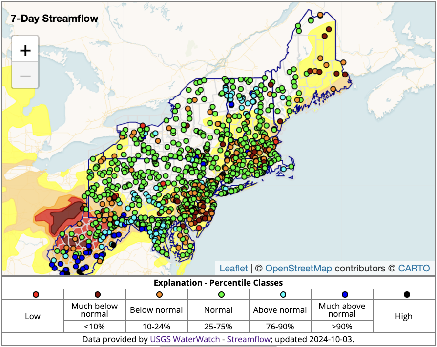
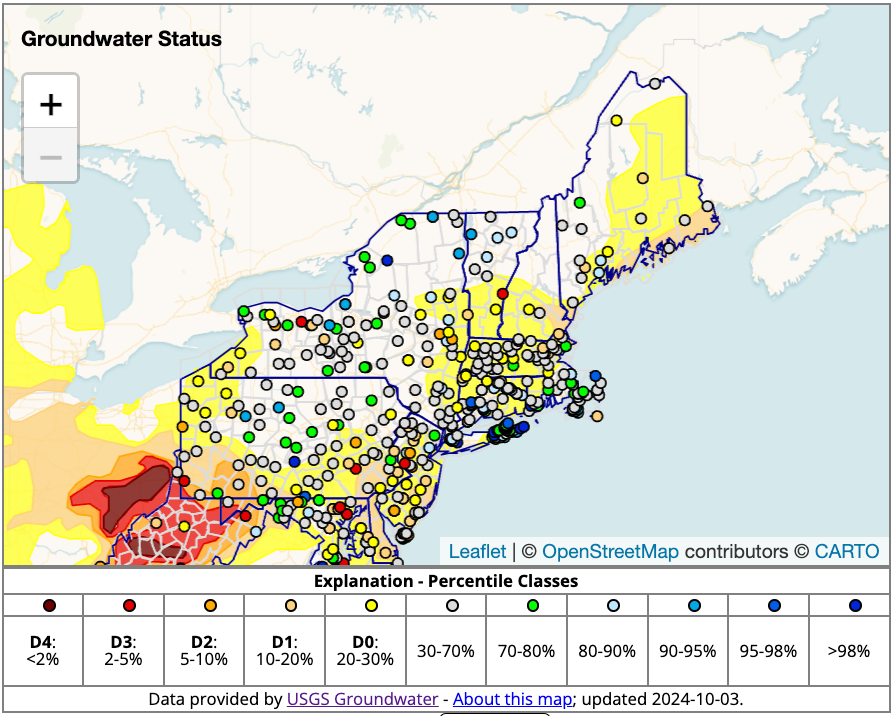
Figure 3: Groundwater Conditions for the Northeast U.S.
Key takeaway: Groundwater status across the Northeast supports the need to closely monitor conditions in the next few weeks. The predominance of groundwater in the 20th to 70th percentiles, combined with an expectation for below-normal precipitation in the coming weeks, points to either status quo or a shift toward further degradation and drying.
Regional Drought Impacts
- Maine:
- September 28, 2024: Bangor Daily News - Rains Did not Alleviate Drought
- September 24, 2024: News Center Maine - Other Drought Concerns
- September 22, 2024: Bangor Daily News - Dry Summer in Maine
- Massachusetts:
- October 1, 2024: Sturbridge, MA - Voluntary Water Ban
- September 19, 2024: NBC10 Boston - Thumbs Up for Fall Foliage
- September 17, 2024: The Sun Chronicle - Very Little Rain in Attleboro
- New Hampshire:
- September 26, 2024: WMUR 9 - Flash Drought and a Water Conservation Request
- New York:
- September 24, 2024: WENY News - Impacts on Fall Foliage
- Vermont:
- September 19, 2024: WCAX3 - Vermont's Variable Weather Impacts Agriculture
Report your local drought impacts by submitting a Condition Monitoring Observer Report:
Outlooks and Potential Impacts for the Northeast
- The next two weeks are likely to be status quo for dryness and drought in most of the Northeast. Odds favor below-normal precipitation, but cooler temperatures may help balance the equation in favor of little change. Coastal New England and portions of Massachusetts may be the exception and experience some degradation of conditions.
- Tropical system development continues in the Atlantic and will influence dryness and drought status beyond the next two weeks. Continue to monitor advisories and updates from the National Hurricane Center.
- The outlook for October is for likely above-normal temperatures and equal chances of above-, below-, or near-normal precipitation, favoring status quo or some modest expansion of dryness and drought.
Figure 3: 8–14 Day Precipitation Outlook for October 10–16, 2024
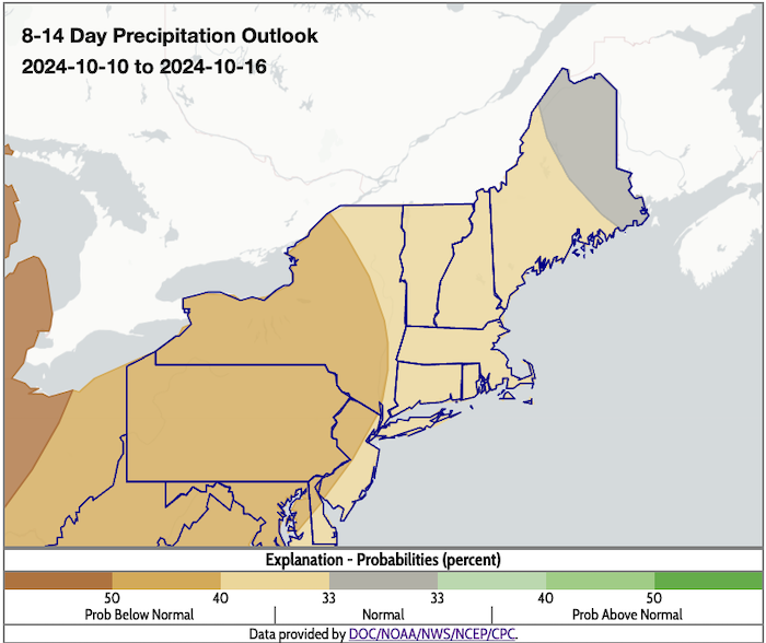
Figure 4: 8–14 Day Temperature Outlook for October 10–16, 2024
Key Takeaway: Likely cooler-than-normal temperatures should help limit the expansion of dryness and drought.
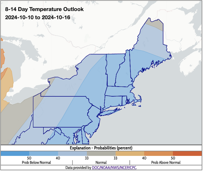
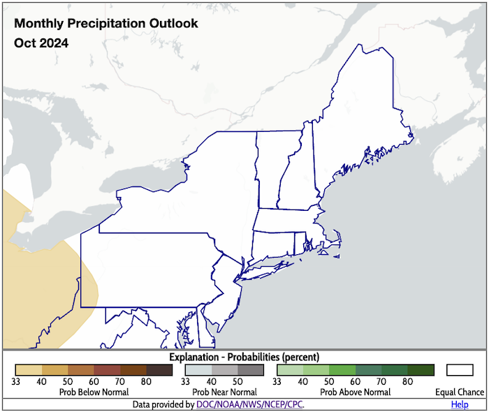
Figure 5: Monthly Temperature and Precipitation Outlooks for October 2024
Key Takeaway: The Climate Prediction Center’s monthly outlooks indicate existing areas of drought in the Northeast may not see improvement in October. This side-by-side display of the temperature and precipitation outlooks for October does not hold much promise for reductions in precipitation deficits.

Prepared By
Sylvia Reeves
NOAA/National Integrated Drought Information System (NIDIS), CU Boulder/Cooperative Institute for Research in Environmental Sciences (CIRES)
Samantha Borisoff, Jessica Spaccio, Keith Eggleston, Art DeGaetano
Northeast Regional Climate Center
Ellen Mecray
Regional Climate Services Director, Eastern Region, NOAA
Gardner Bent
USGS New England Water Science Center
In partnership with National Weather Service Offices of the Northeast and State Climate Offices of the Northeast.
This drought status update is issued in partnership between the National Oceanic and Atmospheric Administration (NOAA), Northeast Regional Climate Center, U.S. Geological Survey, and the U.S. Department of Agriculture (USDA) to communicate concern for drought expansion and intensification within the Northeast U.S. based on recent conditions and the forecasts and outlooks. NIDIS and its partners will issue future drought status updates as conditions evolve.
