First Drought then Flood; Weather Whiplash Eases Some Drought Concerns but Groundwater Should Still Be Monitored
Key Points
- According to the latest U.S. Drought Monitor (valid on Tuesday, December 10, 2024), almost all of the Northeast Drought Early Warning System (DEWS) is experiencing dryness and drought.
- Widespread rainfall across the region on Wednesday and lake effect snow events earlier this month improved conditions. Rain and lake effect snow greatly reduced fire risk, and benefited surface soils and streamflows (where not frozen).
- Extreme Drought (D3) continued to impact Massachusetts. Severe Drought (D2) conditions also continued for most of southern New England, southeast New York, and Long Island. Rain this week will take the edge off these conditions, and precipitation deficit improvement is anticipated.
- At some locations, groundwater recharge will lag behind moisture replenishment in soils and in streams. As the top layers of soil begin to freeze and become snow covered, additional snow melt and rain may not filter through to fully recharge all wells.
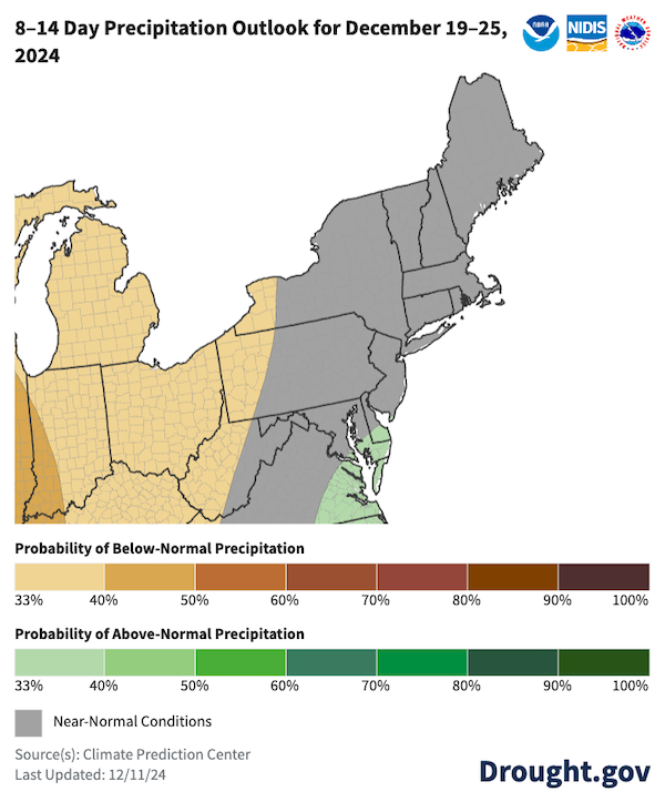
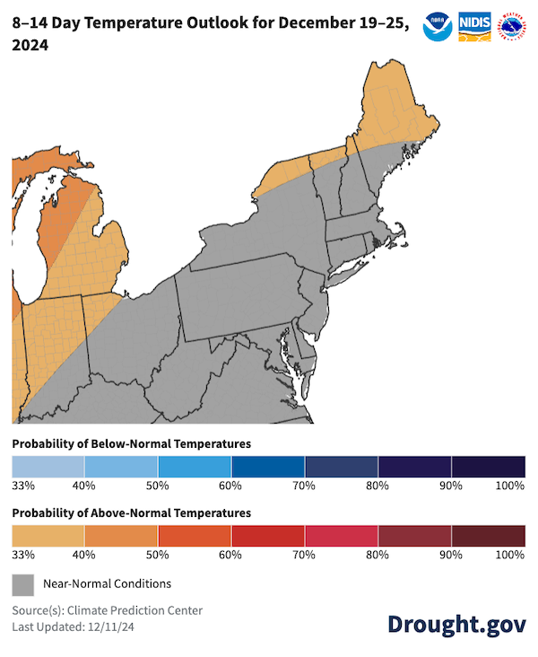
- The National Weather Service Climate Prediction Center’s (CPC’s) 8–14 day outlooks don’t offer significant chances for the above-normal precipitation that we need or the above-normal temperatures that would allow for groundwater recharge in this time frame.
- States just to our south also continued to struggle with Moderate to Extreme Drought (D1-D3), with late growing season impacts to Christmas trees and harvest difficulties for New Jersey cranberries.
Learn more about precipitation deficits from the Northeast Regional Climate Center.
The U.S. Drought Monitor depicts the location and intensity of drought across the country. The map uses 5 classifications: Abnormally Dry (D0), showing areas that may be going into or are coming out of drought, and four levels of drought (D1–D4).
The U.S. Drought Monitor is a joint effort of the National Oceanic and Atmospheric Administration, U.S. Department of Agriculture, and National Drought Mitigation Center.
A drought index combines multiple drought indicators (e.g., precipitation, temperature, soil moisture) to depict drought conditions. For some products, like the U.S. Drought Monitor, authors combine their analysis of drought indicators with input from local observers. Other drought indices, like the Standardized Precipitation Index (SPI), use an objective calculation to describe the severity, location, timing, and/or duration of drought.
Learn MorePeriods of drought can lead to inadequate water supply, threatening the health, safety, and welfare of communities. Streamflow, groundwater, reservoir, and snowpack data are key to monitoring and forecasting water supply.
Learn MoreDrought can reduce the water availability and water quality necessary for productive farms, ranches, and grazing lands, resulting in significant negative direct and indirect economic impacts to the agricultural sector. Monitoring agricultural drought typically focuses on examining levels of precipitation, evaporative demand, soil moisture, and surface/groundwater quantity and quality.
Learn MoreU.S. Drought Monitor Categories
D0 - Abnormally Dry
Abnormally Dry (D0) indicates a region that is going into or coming out of drought. View typical impacts by state.
D1 - Moderate Drought
Moderate Drought (D1) is the first of four drought categories (D1–D4), according to the U.S. Drought Monitor. View typical impacts by state.
D2 - Severe Drought
Severe Drought (D2) is the second of four drought categories (D1–D4), according to the U.S. Drought Monitor. View typical impacts by state.
D3 - Extreme Drought
Extreme Drought (D3) is the third of four drought categories (D1–D4), according to the U.S. Drought Monitor. View typical impacts by state.
D4 - Exceptional Drought
Exceptional Drought (D4) is the most intense drought category, according to the U.S. Drought Monitor. View typical impacts by state.
Total Area in Drought (D1–D4)
Percent area of the Northeast Drought Early Warning System that is currently in drought (D1–D4), according to the U.S. Drought Monitor.
The U.S. Drought Monitor depicts the location and intensity of drought across the country. The map uses 5 classifications: Abnormally Dry (D0), showing areas that may be going into or are coming out of drought, and four levels of drought (D1–D4).
The U.S. Drought Monitor is a joint effort of the National Oceanic and Atmospheric Administration, U.S. Department of Agriculture, and National Drought Mitigation Center.
This U.S. Drought Monitor is released every Thursday morning, with data valid through Tuesday at 7 a.m. ET.
A drought index combines multiple drought indicators (e.g., precipitation, temperature, soil moisture) to depict drought conditions. For some products, like the U.S. Drought Monitor, authors combine their analysis of drought indicators with input from local observers. Other drought indices, like the Standardized Precipitation Index (SPI), use an objective calculation to describe the severity, location, timing, and/or duration of drought.
Learn MorePeriods of drought can lead to inadequate water supply, threatening the health, safety, and welfare of communities. Streamflow, groundwater, reservoir, and snowpack data are key to monitoring and forecasting water supply.
Learn MoreDrought can reduce the water availability and water quality necessary for productive farms, ranches, and grazing lands, resulting in significant negative direct and indirect economic impacts to the agricultural sector. Monitoring agricultural drought typically focuses on examining levels of precipitation, evaporative demand, soil moisture, and surface/groundwater quantity and quality.
Learn MoreThis update is based on data available as of Thursday, December 12, 2024 at 10 a.m. ET. We acknowledge that conditions are evolving.
Current Conditions in the Northeast
- New York, Connecticut, and Massachusetts are maintaining their drought advisories, watches, warnings.
- Recent rains and lake effect snow helped reduce fire risk and improve streamflow. Monitoring groundwater recharge will be key for drinking water management.
Figure 1. Keetch-Byram Drought Index (KBDI) for the Northeast
Key takeaway: Fire risk improved greatly across the region. Late November and early December rain and snowfall reduced the fire risk.
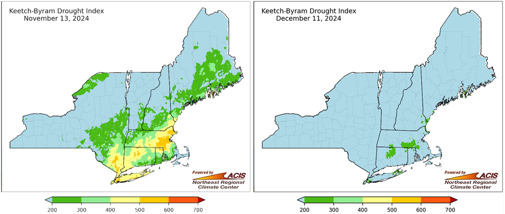
Figure 2. Realtime Streamflow Conditions
Key takeaway: Earlier this month, streamflow conditions improved in western New York state with multiple rounds of lake effect snow and snow from fast-moving clipper systems. Many southern New York and New England rivers and streams recovered with very recent rainfall. This weather whiplash (quickly moving from dry surface conditions to wet) was punctuated by flood advisories, watches and warnings in place at mid week. Precipitation—mostly in the form of rain—will improve streamflow in the short term.
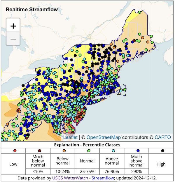
Figure 3. Streamflow at Gates Brook Near West Boylston, Massachusetts
Key takeaway: At Gates Brook near West Boylston, Massachusetts, streamflow had been much below normal since September. Mid-week rains will improve flow conditions at this site.
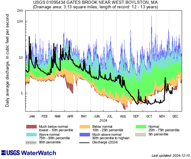
Figure 4. Groundwater Conditions for the Northeast U.S.
Key takeaway: Mixed groundwater conditions are the result of a series of snow and rain events over the past few weeks. Groundwater conditions Improved in many locations, but the results are not uniform. Groundwater monitoring before ground freeze will be helpful to determine recovery.
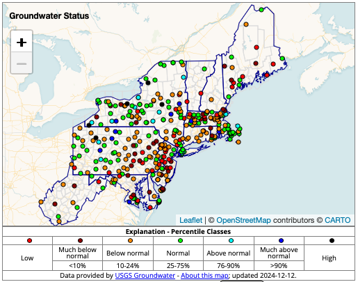
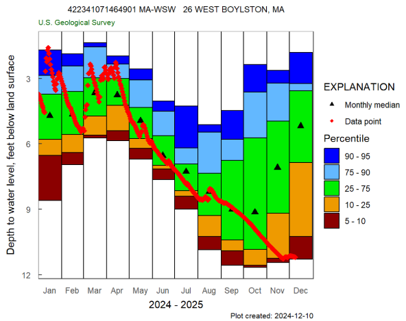
Figure 5. West Boylston, Massachusetts Groundwater Observation Well
Key Takeaway: Fall precipitation deficits are evident in the groundwater well at this location. Weather whiplash into a widespread rain event promises improvements for this site and others experiencing Extreme Drought (D3) in Massachusetts.
State and Regional Drought Impacts
New York
- Regional reservoirs storing water for New York City continue to show lower capacities.
- Work on the Delaware Aqueduct project is on hold for now. Work will resume when conditions are more favorable.
- The New York Department of Environmental Conservation (DEC) has kept most of the state in a drought watch, except for several counties in southeastern New York (including New York City), which are under a drought warning.
- New York City’s drought warning, declared on November 18, 2024, was the first drought warning issued there in more than 20 years. City agencies and residents are asked to take water conservation measures.
Connecticut
- Connecticut’s Interagency Drought Workgroup met on December 5, 2024 to review conditions and made the recommendation for the entire state to remain in a Stage 2 drought advisory level.
- Just before the Thanksgiving, Connecticut’s governor lifted the statewide burn ban on some public lands after an unprecedented fall fire season.
Massachusetts
- Massachusetts Critical Drought (Level 3) persists across most of the state.
Maine
- On November 21, Maine’s Drought Task Force reported several drought impacts:
- Harvest activities were largely completed before significant drought set in. A survey of Maine’s 16 Soil & Water Conservation Districts indicates that most areas are expressing concerns over low farm ponds, wells, and streams. Normal precipitation levels will be needed to restore agricultural water supplies for the 2025 growing season.
- The Drinking Water Program was notified of apparent drought-related water chemistry changes in Aroostook County, and a supplier in York County temporarily hauled water to meet water quantity demand until a new well was brought online. Twelve privately owned wells have reportedly run dry during this year. Of these, ten were reported since the beginning of September 2024. Maine is collecting information about dry wells in the state.
- Water levels at a salmon hatchery in northern Maine are running so low that 24-inch salmon are dying due to lack of oxygen. All rivers and streams in Central Aroostook were flowing at very low levels. Substantial rain is needed before the winter freezes.
New Jersey
- New Jersey’s Manasquan Reservoir, west of Trenton, supplies 1.2 million people in Monmouth and Ocean counties with drinking water.
- The reservoir received rain this week but is still low. On December 11, 2024, News12 New Jersey reported local residents’ concerns.
- Portions of southern New Jersey have experienced Severe Drought (D2) and Extreme Drought (D3) since November 5, 2024.
Drought Impacts in the News
- Connecticut
- December 2, 2024: Fox61 - Connecticut Christmas trees hold up well despite fall’s drought
- Maine
- November 22, 2024: WGME - Harrison fire response complicated by drought and reduced natural water supplies
- Massachusetts
- December 11, 2024: Spectrum News - Drought Conditions Remain in Massachusetts Despite Wednesday’s Rainfall
- December 6, 2024: State of Massachusetts - Critical Drought Persists Across Massachusetts
- December 6, 2024: WGBH - The Rain Helped But the Drought is Not Over
- December 2, 2024: Patch.com - Extreme Drought Spurs Danvers Water Use Prohibition
- New Hampshire
- November 21, 2024: New Hampshire Public Radio (NHPR) - Rain will help NH's drought conditions. But it's not enough.
- New York
- December 11, 2024: Gothamist - Rain Is Not Enough to End the City’s Drought Warning
- December 10, 2024: amNY - Rain Brings Reversal of Fireworks and Grilling Ban
- Rhode Island
- December 4, 2024: State of Rhode Island - Governor McKee issues Drought Advisory
- Vermont
- December 9, 2024: MSN - Drought Impacts Ski Resort
- November 29, 2024: Vermont Public - Winter Forecast Shows Drought Could Persist
Regional
December 10, 2024: History New Network - The Northeast Caught Fire This Fall; Recalling Its Past
Report your local drought impacts by submitting a Condition Monitoring Observer Report:
Outlooks and Potential Impacts for the Northeast
- The National Weather Service Climate Prediction Center’s (CPC’s) 8–14 day outlooks suggest near-normal precipitation and temperatures for most of the region. Any additional precipitation before ground freeze would be helpful.
- With ground freeze and snow cover pending, groundwater recharge should still be monitored.
- Agricultural, hydrological, ecological and fire conditions for the spring will be influenced by the extent of the drought recovery this winter.
Figure 6. 8–14 Day Precipitation and Temperature Outlooks for December 19–25
Key Takeaway: Over the next 8-14 days, near-normal precipitation is favored for most of the region. Only western New York is expected to see slightly below normal precipitation. Temperature wise, near-normal conditions are favored for most of the region. Slightly above normal temperatures are expected for the northernmost portions of New York, Vermont, New Hampshire and Maine. Any rain or snow melt under slightly above-normal temperatures should allow for additional improvement to groundwater levels before winter freeze.
Additional Resources
- View previous Northeast DEWS Drought Status Updates.
- The next NOAA Eastern Region Climate Services webinar is Thursday, December 19 at 9:30 a.m. ET. There will be a review of December conditions and an update on ENSO conditions before diving into a presentation on the winter outlook. Register here.
- If you can’t make the Eastern Region Climate Services webinar ENSO update on Thursday, keep tabs on expected changes with Climate.gov’s ENSO Blog.
- New York Department of Environmental Conservation Drought Conditions Map
- Massachusetts Drought Status Map
- Maine Dry Well Survey Map
- Susquehanna River Basin Commission: Drought Status and Information page
- Delaware River Basin Commission: Snapshot for Flow and Drought Management
- New Jersey Drought Status and Conditions provides information on drinking water status and conditions.
Prepared By
Sylvia Reeves
NOAA/National Integrated Drought Information System (NIDIS), CU Boulder/Cooperative Institute for Research in Environmental Sciences (CIRES)
Samantha Borisoff, Jessica Spaccio, Keith Eggleston, Natalie Umphlett, and Art DeGaetano
Northeast Regional Climate Center
Ellen Mecray
Regional Climate Services Director, Eastern Region, NOAA
Gardner Bent
USGS New England Water Science Center
In partnership with National Weather Service Offices of the Northeast and State Climate Offices of the Northeast.
This drought status update is issued in partnership between the National Oceanic and Atmospheric Administration (NOAA), Northeast Regional Climate Center, U.S. Geological Survey, and the U.S. Department of Agriculture (USDA) to communicate concern for drought expansion and intensification within the Northeast U.S. based on recent conditions and the forecasts and outlooks. NIDIS and its partners will issue future drought status updates as conditions evolve.


