Dryness and Drought Improve Slightly with Recent Rain and Snowmelt, but Wildfire Risk Is a Concern
Key Points
- According to the latest U.S. Drought Monitor (valid on Tuesday, March 11, 2025), the Northeast Drought Early Warning System (DEWS) saw a reduction of dryness and drought. Severe Drought (D2) was eliminated in Connecticut, Massachusetts, and southeastern New York.
- Moderate Drought (D1) remains in place for portions of New York and New England. Extensive areas of Abnormal Dryness (D0) remain in all states.
- Warmer and windier weather increased fire activity in several states.
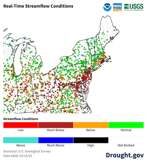
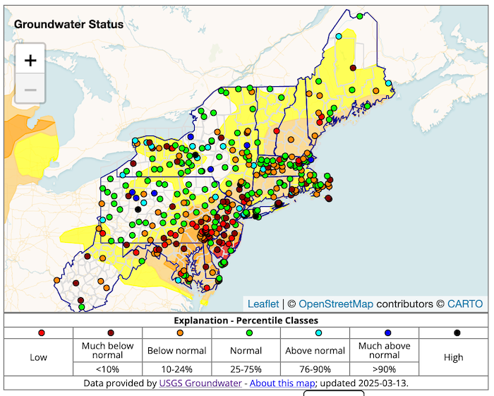
- Streamflows are normal to much above normal in most of the region, except for several sites in southern New England. Groundwater status is mixed across the region.
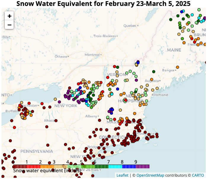
- Snowpack conditions are mixed across the region—with less than 2 inches of snow water equivalent (SWE) across southern New England and western New York, while other sites had more than 8 inches.
- Rain is expected for this weekend. Quick-responding streams will see a short-term increase in streamflow with this precipitation (and any additional snow melt).
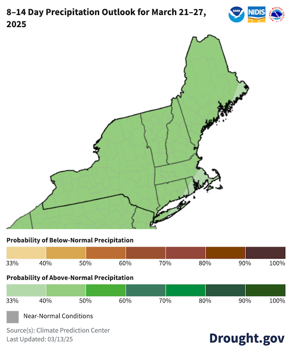
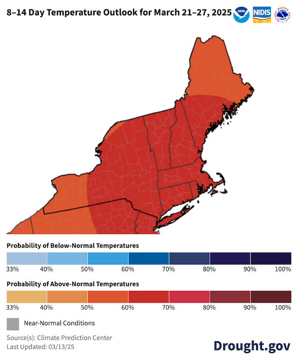
- The National Weather Service Climate Prediction Center’s (CPC’s) 8–14 day outlooks indicate good chances for a warmer and wetter weather pattern later in March. This should continue to decrease dryness and improve drought conditions, but it may not completely eliminate the fire risk or water resource challenges for all locations.
- States just to the south continued to struggle with Moderate to Extreme Drought (D1-D3). Delaware, New Jersey, and southeastern Pennsylvania have been negatively impacted for much of the winter, raising concerns about reservoir levels, fire activity, and agricultural impacts.
Learn more about precipitation deficits from the Northeast Regional Climate Center.
The U.S. Drought Monitor depicts the location and intensity of drought across the country. The map uses 5 classifications: Abnormally Dry (D0), showing areas that may be going into or are coming out of drought, and four levels of drought (D1–D4).
The U.S. Drought Monitor is a joint effort of the National Oceanic and Atmospheric Administration, U.S. Department of Agriculture, and National Drought Mitigation Center.
A drought index combines multiple drought indicators (e.g., precipitation, temperature, soil moisture) to depict drought conditions. For some products, like the U.S. Drought Monitor, authors combine their analysis of drought indicators with input from local observers. Other drought indices, like the Standardized Precipitation Index (SPI), use an objective calculation to describe the severity, location, timing, and/or duration of drought.
Learn MorePeriods of drought can lead to inadequate water supply, threatening the health, safety, and welfare of communities. Streamflow, groundwater, reservoir, and snowpack data are key to monitoring and forecasting water supply.
Learn MoreDrought can reduce the water availability and water quality necessary for productive farms, ranches, and grazing lands, resulting in significant negative direct and indirect economic impacts to the agricultural sector. Monitoring agricultural drought typically focuses on examining levels of precipitation, evaporative demand, soil moisture, and surface/groundwater quantity and quality.
Learn MoreU.S. Drought Monitor Categories
D0 - Abnormally Dry
Abnormally Dry (D0) indicates a region that is going into or coming out of drought. View typical impacts by state.
D1 - Moderate Drought
Moderate Drought (D1) is the first of four drought categories (D1–D4), according to the U.S. Drought Monitor. View typical impacts by state.
D2 - Severe Drought
Severe Drought (D2) is the second of four drought categories (D1–D4), according to the U.S. Drought Monitor. View typical impacts by state.
D3 - Extreme Drought
Extreme Drought (D3) is the third of four drought categories (D1–D4), according to the U.S. Drought Monitor. View typical impacts by state.
D4 - Exceptional Drought
Exceptional Drought (D4) is the most intense drought category, according to the U.S. Drought Monitor. View typical impacts by state.
Total Area in Drought (D1–D4)
Percent area of the Northeast Drought Early Warning System that is currently in drought (D1–D4), according to the U.S. Drought Monitor.
The U.S. Drought Monitor depicts the location and intensity of drought across the country. The map uses 5 classifications: Abnormally Dry (D0), showing areas that may be going into or are coming out of drought, and four levels of drought (D1–D4).
The U.S. Drought Monitor is a joint effort of the National Oceanic and Atmospheric Administration, U.S. Department of Agriculture, and National Drought Mitigation Center.
This U.S. Drought Monitor is released every Thursday morning, with data valid through Tuesday at 7 a.m. ET.
A drought index combines multiple drought indicators (e.g., precipitation, temperature, soil moisture) to depict drought conditions. For some products, like the U.S. Drought Monitor, authors combine their analysis of drought indicators with input from local observers. Other drought indices, like the Standardized Precipitation Index (SPI), use an objective calculation to describe the severity, location, timing, and/or duration of drought.
Learn MorePeriods of drought can lead to inadequate water supply, threatening the health, safety, and welfare of communities. Streamflow, groundwater, reservoir, and snowpack data are key to monitoring and forecasting water supply.
Learn MoreDrought can reduce the water availability and water quality necessary for productive farms, ranches, and grazing lands, resulting in significant negative direct and indirect economic impacts to the agricultural sector. Monitoring agricultural drought typically focuses on examining levels of precipitation, evaporative demand, soil moisture, and surface/groundwater quantity and quality.
Learn MoreThis update is based on data available as of Thursday, March 13, 2025 at 10 a.m. ET. We acknowledge that conditions are evolving.
Current Conditions in the Northeast
- Dryness and drought in the region is keeping fire risk top of mind, especially under windy spring conditions. Outdoor burn restrictions are in place within some counties, municipalities, and regional planning areas in New York, Connecticut, and Massachusetts.
- Realtime streamflow is normal to much above normal in most of the region. However, in southern New England, several streamgages in Connecticut, Massachusetts, and Rhode Island registered below-normal and much-below-normal conditions.
- Groundwater recharge remains mixed, but as soils warm, recharge should improve. Since late October 2024, groundwater levels at the U.S. Geological Survey observation well RI-BUW 395 in Burrillville, Rhode Island were in the lowest 25% of recorded values until a recent rainfall event on March 5–6, 2025.
- A range of low and much-below-normal groundwater reporting sites adjacent to normal or above-normal reporting sites may mean that soils around some gauges are still frozen and blocking recharge.
- There was less than 2 inches of water in the snowpack across southern New England and western New York, according to the Northeast Regional Climate Center Snow Survey for early March. However, many sites in northern New York had snow water equivalent (SWE) values closer to 8 or 9 inches.
Streamflow Remains Normal to Above Normal in Most of New England
Groundwater Conditions Are Mixed Throughout the Region
Snow Conditions Are Mixed in the Northeast
Drought Impacts in the News
- Connecticut
- March 12. 2025: CT Post - Winter Was Colder than Average, but Connecticut Still Experienced a Snow Drought
- March 8, 2025: NBC Connecticut - Snow Season Conclusion and Fire Concerns are Related
- March 5, 2025: FOX61 - Drought Conditions Spark Concerns of Brush Fires
- Massachusetts
- March 10, 2025: NBC Boston - Fire Season Looms
- March 8, 2025: NBC Boston - Frozen Ground Held Off Groundwater Recharge
- March 8, 2025: The Berkshire Eagle - Great Barrington Suspends Outdoor Burns Due to Drought and Winds
- New York
- March 11, 2025: ABC News - Parts of Northeast and Southwest Bracing for Elevated Fire Danger
- March 8, 2025: Silive.com - Staten Island Wildfire Risk
- March 8, 2025: USA Today - Governor Declares State of Emergency for Long Island Wildfires
Regional
- March 11, 2025: Delaware Department of Agriculture - Weather Ignites Wildfire Concerns
- March 10, 2025: Marine Link - Great Lakes Water Levels Below Average
- March 9, 2025: CBS News Philadelphia - South Jersey Fire Risk Is High
- March 8, 2025: WBOC-TV - Elevated Fire Risk in Delaware
- February 26, 2025: WFMZ - Agricultural Concerns Are Looming in Pennsylvania
Report your local drought impacts by submitting a Condition Monitoring Observer Report:
Outlooks and Potential Impacts for the Northeast
- Rain is expected for this weekend. Quick-responding streams will see a short-term increase in streamflow with this precipitation (and any additional snow melt).
- Later in March, the National Weather Service Climate Prediction Center’s (CPC’s) 8–14 day outlooks favor wetter- and warmer-than-normal conditions from March 21–27.
- Drought and dry conditions in some areas will continue to improve, but this will not completely eliminate fire risk and water resource challenges for all locations.
Warmer and Wetter Conditions Predicted for March 21-27
Additional Resources
- View previous Northeast DEWS Drought Status Updates.
- View weekly drought updates from the Northeast Regional Climate Center.
- The next NOAA Eastern Region Climate Services webinar is Thursday, March 27 at 9:30 a.m. ET. The webinar will feature a presentation on the spring flood outlook. Register here.
- Massachusetts debuts new social media campaign on drought and water conservation.
- New York Department of Environmental Conservation Fire Danger Map
- Massachusetts Drought Status Map
- New Jersey Forest Fire Service Dashboard
- Susquehanna River Basin Commission - Drought Status and Information page
- Delaware River Basin Commission - Snapshot for Flow and Drought Management
- New Jersey Drought Status and Conditions provides information on drinking water status and conditions, as well as reservoir levels.
- Fire Outlooks from the National Interagency Coordination Center.
Prepared By
Sylvia Reeves
NOAA/National Integrated Drought Information System (NIDIS), CU Boulder/Cooperative Institute for Research in Environmental Sciences (CIRES)
Samantha Borisoff, Jessica Spaccio, Keith Eggleston, Natalie Umphlett, and Art DeGaetano
Northeast Regional Climate Center
Ellen Mecray
Regional Climate Services Director, Eastern Region, NOAA
Gardner Bent
USGS New England Water Science Center
In partnership with National Weather Service Offices of the Northeast and State Climate Offices of the Northeast.
This drought status update is issued in partnership between the National Oceanic and Atmospheric Administration (NOAA), Northeast Regional Climate Center, U.S. Geological Survey, and the U.S. Department of Agriculture (USDA) to communicate concern for drought expansion and intensification within the Northeast U.S. based on recent conditions and the forecasts and outlooks. NIDIS and its partners will issue future drought status updates as conditions evolve.
