Heat Worsens Drought in the Pacific Northwest
Key Points
- The recent heat wave was unprecedented in the contemporary data record. Portland, Oregon hit a record high of 116°F on June 28, 2021 (Portland Airport), breaking the June 27, 2021 record of 112°F, which broke a record of 108°F set just a day earlier. Seattle, Washington (SeaTac Airport) set an all-time high temperature record of 108°F on June 28, 2021, breaking the 104°F record set the day before. The highest recorded temperatures in the area were 118°F on June 28, 2021 measured at The Dalles (Dallesport Airport, WA) and Hermiston, OR.
- 86.7% of the Pacific Northwest DEWS region is in drought, with 31.7% experiencing Extreme (D3) or Exceptional (D4) drought conditions.
- Streamflows for the last 28 days have been below average for portions of Oregon, Idaho, and Washington.
- Nineteen counties in Oregon have drought declarations with three additional requests. At least ten counties in Idaho have declarations of drought emergency. The Washington Department of Ecology has issued a “Drought Advisory” for most of the state, including all areas east of the Cascade Mountains, portions of Southwest Washington and the Washington coast.
- Warm and dry conditions are expected to continue through the rest of July, resulting in more drying of vegetation and crops. Overall, the heat wave is likely to exacerbate the current drought conditions going into late summer (a time of year when it is typically dry).
Current U.S. Drought Monitor map for the Pacific Northwest, as of July 6, 2021. The U.S. Drought Monitor (USDM) is updated each Thursday to show the location and intensity of drought across the country. Drought categories show experts’ assessments of conditions related to dryness and drought including observations of how much water is available in streams, lakes, and soils compared to usual for the same time of year
U.S. Drought Monitor Categories
Current U.S. Drought Monitor map for the Pacific Northwest, as of July 6, 2021. The U.S. Drought Monitor (USDM) is updated each Thursday to show the location and intensity of drought across the country. Drought categories show experts’ assessments of conditions related to dryness and drought including observations of how much water is available in streams, lakes, and soils compared to usual for the same time of year
Current Conditions
- The recent heat wave was unprecedented in the contemporary data record. Portland, Oregon hit a record high of 116°F on June 28, 2021 (Portland Airport), breaking the June 27, 2021 of 112°F, which broke a record of 108°F set just a day earlier. Seattle, Washington (SeaTac Airport) set an all-time high temperature record of 108°F on June 28, 2021, breaking the 104°F record set the day before. The highest recorded temperatures in the area were 118°F on June 28, 2021 measured at The Dalles (Dallesport Airport, WA) and Hermiston, OR.
- 86.7% of the Pacific Northwest DEWS region is in drought, with 31.7% experiencing Extreme (D3) or Exceptional (D4) drought conditions.
- Much of the Pacific Northwest has significantly below-normal soil moisture (below the 5th percentile for this date), which contributes not only to drought but also to wildfire risk (Figure 1).
- As a region, Idaho, Oregon and Washington recorded its second driest spring (March-April-May) on record (period of record: 1895–present), receiving only 45% of normal (1991-2020) precipitation. The record driest spring for the Pacific Northwest was in 1924, with this year being drier than last year during the drought in the region (West Wide Drought Tracker).
- Streamflows for the last 28 days have been below average for parts of the Pacific Northwest (Figure 2). In Idaho, streamflow percentiles on the Big Wood River, Camas Creek (in Blaine County), Big Lost River, Little Lost River, Lemhi River, and Camas Creek (in Clark County) are all in the 1st to 3rd percentile based on a 14-day average. In Eastern Idaho, streamflow percentiles in this region are 3% or less.
Figure 1. 0–10 cm Soil Moisture Percentile: July 1, 2021

Figure 2. Below-Normal 28-Day Average Streamflow Conditions

Drought Impacts
- The record-setting heat wave across the Northwest contributed to worsening drought conditions by continuing to dry soils and vegetation. It also increased fire risk, stressed power grids and water supply, buckled roads, and created human health emergencies and deaths. Oregon Health Authority Statewide Surveillance Summary data show increased visits to emergency departments and urgent care across the state for heat-related injuries, submersion and non-fatal drowning, and a subset of symptoms that may be related to recreational exposure to harmful algal blooms (cyanobacteria). The full impacts to human health are still being assessed.
- Nineteen counties in Oregon have drought declarations with three additional requests. At least ten counties in Idaho have declarations of drought emergency. The Washington Department of Ecology has issued a “Drought Advisory” for most of the state, including all areas east of the Cascade Mountains, portions of Southwest Washington, and the Washington coast.
- The National Interagency Fire Center moved to National Preparedness Level 4 (out of 5) “due to a significant increase in fire activity in multiple geographic areas, as well as increased competition for shared resources.” This is the second earliest increase to PL4 since records began in 1990 (behind 2012).
- The Washington Department of Natural Resources (DNR) announced a statewide burn ban. The order bans outdoor burning, campfires, the use of charcoal briquettes, and prescribed burns on all forest lands within DNR’s fire protection. The ban is expected to last through September 30, but could be extended if this year's wildfire season lasts longer than usual as some climate experts expect.
- Agricultural impacts were widespread across the region, including having farm workers harvesting cherries at night to avoid high temperatures and hauling water for livestock to new areas. Crops with and without irrigation have been impacted with serious wilt and scorched leaves. Apples required protection to reduce sun burnt fruit, and high temperatures led to early flowering in alfalfa and early irrigation of pastures. Winter wheat conditions in Oregon, which are representative across the region, are some of the worst since 2001 and comparably bad to 2002 (Figure 3). Grasshoppers impacted crops and rangeland, especially in Idaho, Oregon, and parts of Montana (USDA National Agricultural Statistics Service).
- Waterways and reservoirs are already warming to unsafe levels for various fish species, including salmonids. At The Dalles on the Columbia River, water temperatures increased almost 4°F over the last week (Figure 5). Increased warming could result in more disease prevalence and death. The Oregon Department of Fish and Wildlife has implemented emergency regulations in several angling zones.
- The Idaho Department of Water Resources has issued a curtailment of groundwater pumping in the Bellview Triangle as of July 1, 2021 because of drought conditions in the Big Wood Basin.
Figure 3. Idaho, Oregon, and Washington Winter Wheat Conditions

Figure 4. Washington Pasture and Range Conditions
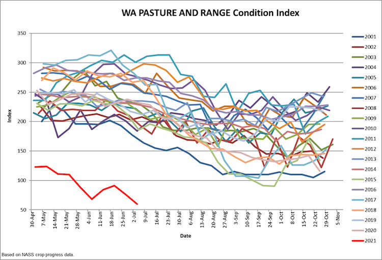
Figure 5. Stream Temperature from the Columbia River at The Dalles, OR

If you are seeing additional impacts or different impacts of the drought where you live, please let us know!
Outlook and Potential Impacts
- Warm and dry conditions are expected to dominate through July, resulting in more drying of vegetation and crops. Overall, the heat wave is likely to exacerbate the current drought conditions going into late summer (a time of year when it is typically dry).
- The official July-August-September outlook from the Climate Prediction Center (Figures 6 and 7) shows higher chances of above-normal temperatures and below-normal precipitation for most of the region, which indicates that drought conditions are likely to persist or deteriorate further in the coming months.
- For many locations across the region, the NOAA Northwest River Forecast Center Water Supply Forecast ranks in the lowest 10% for April through September (Figure 8).
- The Significant Wildland Fire Potential Outlook shows higher chances of wildfire potential across the Pacific Northwest region (Figure 9).
- Power generation and distribution might be affected as summer progresses. Some power companies are shutting down auto reset when power is disrupted, requiring physical examination due to the exacerbated risk of wildfire.
Figure 6. Three-Month Temperature Outlook

Figure 7. Three-Month Precipitation Outlook

Figure 8. Ensemble Streamflow Prediction Water Supply Forecast: April-September

Figure 9. Significant Wildland Fire Potential Outlook: July 2021

For More Information
- NIDIS and its partners will issue future updates as conditions evolve.
- More local information is available from the following resources:
- For additional regional drought and wildfire resource information, see 2021 Pacific Northwest Drought Resources.
- Watch the webinar recording or read a recap from the June 28 Pacific Northwest Drought & Climate Outlook webinar.
- Federal drought declarations are available from the U.S. Department of Agriculture Farm Service Agency.
Prepared By
Britt Parker
NOAA National Integrated Drought Information System
Karin Bumbaco
Office of the Washington State Climatologist
David Hoekema
Idaho Department of Water Resources
Ryan Andrews
Oregon Department of Water Resources
Larry O’Neill
Oregon Climate Service
Scott Oviatt
USDA Natural Resources Conservation Service
Holly Prendeville
USDA Northwest Climate Hub
This drought status update is issued in partnership with the states of Oregon, Washington, and Idaho, the USDA Northwest Climate Hub, the USDA Natural Resources Conservation Service, and the Oregon Climate Change Research Institute to communicate a potential area of concern for drought expansion and/or development within the Pacific Northwest based on recent conditions and the upcoming forecast. NIDIS and its partners will issue future drought status updates as conditions evolve.