Drought—and Its Impacts—Intensified, But Relief May Arrive This Fall.
Key Points
- According to the U.S. Drought Monitor, 61% of the Pacific Northwest Drought Early Warning System region is experiencing Moderate to Exceptional Drought conditions (D1–D4). Drought is most severe in central Washington (Extreme Drought, D3) and western Montana (Exceptional Drought, D4).
- The Pacific Northwest’s aggressive wildfire season persists.
- As of August 25, Oregon preliminarily reported over 1,500,000 acres burned so far in 2024, which is far above the annual average over the past 10 years and is now greater than the previous high in 2012. The largest of the 2024 wildfires are the Durkee and Cow Valley Fire and Battle Mountain Complex Fire.
- The Paddock Fire in Idaho burned more than 180,000 acres, making it the third largest wildfire in state history.
- Persistent warmer-than-normal summer temperatures and below-normal precipitation across Washington continue to limit water supply. Reservoir elevations in parts of Washington dropped to near-record lows, and streamflows continue to decline.
Current U.S. Drought Monitor map for the Pacific Northwest, as of August 27, 2024. The U.S. Drought Monitor (USDM) is updated each Thursday to show the location and intensity of drought across the country using 5 classifications: Abnormally Dry (D0), showing areas that may be going into or are coming out of drought, and four levels of drought (D1–D4).
The U.S. Drought Monitor is a joint effort of the National Drought Mitigation Center, U.S. Department of Agriculture, and National Oceanic and Atmospheric Administration.
A drought index combines multiple drought indicators (e.g., precipitation, temperature, soil moisture) to depict drought conditions. For some products, like the U.S. Drought Monitor, authors combine their analysis of drought indicators with input from local observers. Other drought indices, like the Standardized Precipitation Index (SPI), use an objective calculation to describe the severity, location, timing, and/or duration of drought.
Learn MorePeriods of drought can lead to inadequate water supply, threatening the health, safety, and welfare of communities. Streamflow, groundwater, reservoir, and snowpack data are key to monitoring and forecasting water supply.
Learn MoreDrought can reduce the water availability and water quality necessary for productive farms, ranches, and grazing lands, resulting in significant negative direct and indirect economic impacts to the agricultural sector. Monitoring agricultural drought typically focuses on examining levels of precipitation, evaporative demand, soil moisture, and surface/groundwater quantity and quality.
Learn MoreU.S. Drought Monitor Categories
D0 - Abnormally Dry
Abnormally Dry (D0) indicates a region that is going into or coming out of drought. View typical impacts by state.
D1 - Moderate Drought
Moderate Drought (D1) is the first of four drought categories (D1–D4), according to the U.S. Drought Monitor. View typical impacts by state.
D2 - Severe Drought
Severe Drought (D2) is the second of four drought categories (D1–D4), according to the U.S. Drought Monitor. View typical impacts by state.
D3 - Extreme Drought
Extreme Drought (D3) is the third of four drought categories (D1–D4), according to the U.S. Drought Monitor. View typical impacts by state.
D4 - Exceptional Drought
Exceptional Drought (D4) is the most intense drought category, according to the U.S. Drought Monitor. View typical impacts by state.
Total Area in Drought (D1–D4)
Percent area of the states in the Pacific Northwest that is currently in drought (D1–D4), according to the U.S. Drought Monitor.
Current U.S. Drought Monitor map for the Pacific Northwest, as of August 27, 2024. The U.S. Drought Monitor (USDM) is updated each Thursday to show the location and intensity of drought across the country using 5 classifications: Abnormally Dry (D0), showing areas that may be going into or are coming out of drought, and four levels of drought (D1–D4).
The U.S. Drought Monitor is a joint effort of the National Drought Mitigation Center, U.S. Department of Agriculture, and National Oceanic and Atmospheric Administration.
The U.S. Drought Monitor is updated every Thursday morning, with data valid through 7 a.m. ET the previous Tuesday.
A drought index combines multiple drought indicators (e.g., precipitation, temperature, soil moisture) to depict drought conditions. For some products, like the U.S. Drought Monitor, authors combine their analysis of drought indicators with input from local observers. Other drought indices, like the Standardized Precipitation Index (SPI), use an objective calculation to describe the severity, location, timing, and/or duration of drought.
Learn MorePeriods of drought can lead to inadequate water supply, threatening the health, safety, and welfare of communities. Streamflow, groundwater, reservoir, and snowpack data are key to monitoring and forecasting water supply.
Learn MoreDrought can reduce the water availability and water quality necessary for productive farms, ranches, and grazing lands, resulting in significant negative direct and indirect economic impacts to the agricultural sector. Monitoring agricultural drought typically focuses on examining levels of precipitation, evaporative demand, soil moisture, and surface/groundwater quantity and quality.
Learn MoreCurrent Conditions for the Pacific Northwest
For an in-depth recap of current conditions, please see this week’s Pacific Northwest Drought & Climate Outlook Webinar.
- Drought conditions for most of the region continued to deteriorate throughout the summer or remain the same (Figure 1).
- Mid-August storms and cooler weather brought a brief reprieve to drought and wildfire conditions for some areas of the Pacific Northwest, but did not end either.
- Much-above-normal temperatures and evaporative demand continue to define the summer and are anticipated to continue over the next several weeks.
- Streamflow averages across the Pacific Northwest continue to be well below normal since mid-June.
- Over the last 7 days, most of the region was extremely dry, with small amounts of precipitation falling only in northwest Washington and southwest Oregon. However, over the same time period, temperatures were below normal across most of the region.
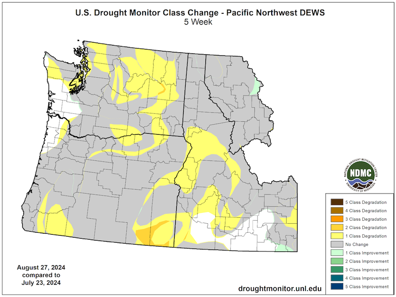
Figure 1: 5-Week U.S. Drought Monitor Change Map (Since July 23, 2024)
Key Takeaway: Drought intensified across central Washington, central Idaho, and southeastern Oregon, with one- to two-class degradations. Drought conditions across other parts of the region did not change from mid-July into late August.
Pacific Northwest Drought Impacts
- Low humidity, lack of precipitation, and extreme winds dried out vegetation and further increased wildfire risks across the region. These conditions led native grasses to cure (the process in which plants dry out and enter dormancy after the summer growing season) early, which exacerbated wildfire risk and decreased forage quality.
- Pasture and range conditions are poor because of lack of precipitation, wildfires, grasshopper outbreaks, extreme heat, and low soil moisture. The poor range conditions triggered supplemental feeding of livestock, some cattle sell-offs, and trucking water to livestock.
- Low streamflows in the Methow River, Yakima River Basin, Wood River, and the Blackfoot River prompted significant concerns about aquatic life. Additional fishing restrictions were implemented across several basins as a result.
- Streamflows across all states continue to be well below normal, with some extremely low conditions. Persistent below-normal precipitation and above-normal temperatures throughout the water year contributed to these low base flows (Figure 2).
- In Washington, low flows in the Methow River resulted in junior water right holders throughout the basin being unable to access their full water allotments. Additionally, the Rimrock Retreat Fire compromised Yakima Tieton Irrigation District’s infrastructure, reducing its ability to supply water to users.
- In northern Idaho, spring wheat shows signs of damage, and in Montana, ranchers began destocking herds and backstocking hay.
- Air quality deteriorated across large parts of the region due to smoke from large wildfires, such as the Paddock Fire in Idaho, Durkee and Cow Valley Fires in Oregon, and Pioneer Fire in Washington.
Report your local drought impacts through a Condition Monitoring Observer Report:
Figure 2: Duration Hydrograph of 7-Day Average runoff in the Pacific Northwest (August 27, 2024)
Key Takeaway: Averaged across the Pacific Northwest, streamflow was below normal (10th–24th percentile) to much below normal (5th percentile) since mid-June of this year.
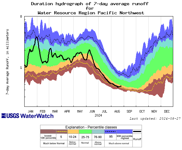
Figure 3: Major U.S. Bureau of Reclamation Storage Reservoirs in the Yakima Basin
Key Takeaway: Much-above-normal temperatures and much-below-average precipitation across the Yakima Basin in Washington resulted in water levels below the capacity of some reservoirs. Water levels in three of five reservoirs were well below 50% of capacity, with Cle Elum reservoir at 8% of capacity.
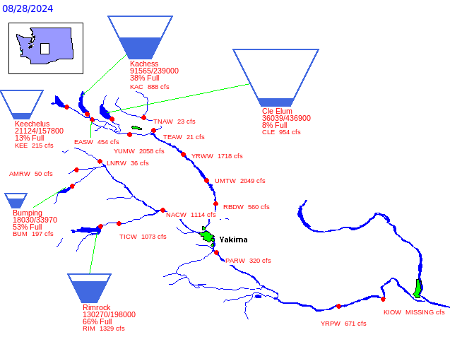
Figure 4: Mudslides Caused by Heavy Precipitation on Burn Scar
Key Takeaway: Burned vegetation in Washington’s Easy Fire exposed soil that could not absorb the heavy rainfall, leading to mudslides that closed State Route 20.
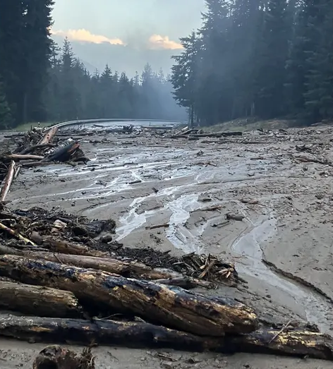
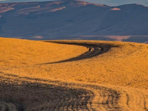
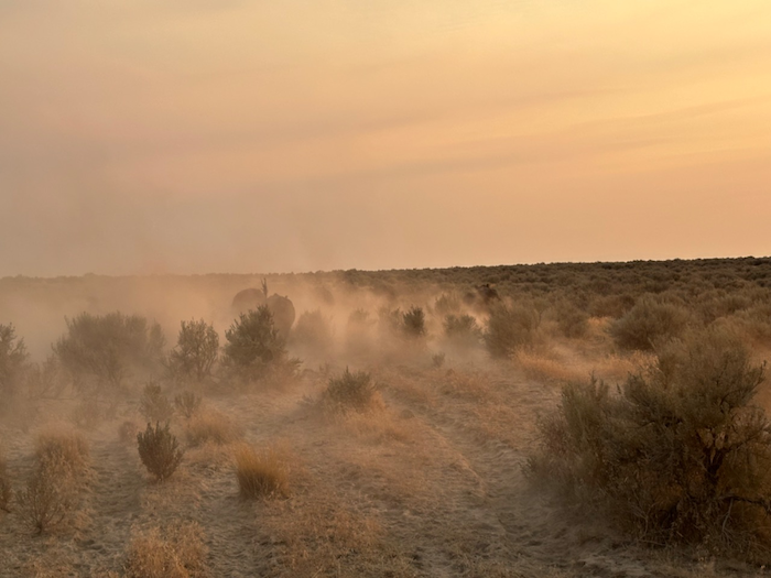
Figure 5: Drought Impacts in the Oregon Range
Key Takeaway: Below-normal precipitation, above-average temperatures, and high evaporative demand contributed to drying soil moisture and deteriorating conditions throughout shrublands in central and eastern Oregon.
Outlooks and Potential Impacts for the Pacific Northwest
For an in-depth overview of seasonal conditions and climate outlooks, please see this week’s Pacific Northwest Drought & Climate Outlook Webinar.
- The National Weather Service Climate Prediction Center’s outlooks for September predict above-normal temperatures across the region, except in Washington, where near-normal temperatures are expected. Precipitation is predicted to be near-normal for most of the region, with above-average precipitation expected for western Washington (Figure 6).
- The U.S. Seasonal Drought Outlook (Figure 7) indicates drought is expected to improve or end in regions east of the Cascade Range in Washington and Oregon. Drought is expected to persist across southeastern Oregon, northern Idaho, and western Montana. Given these seasonal predictions, adverse effects on water supply, human health, and agricultural production in parts of the region are likely to continue.
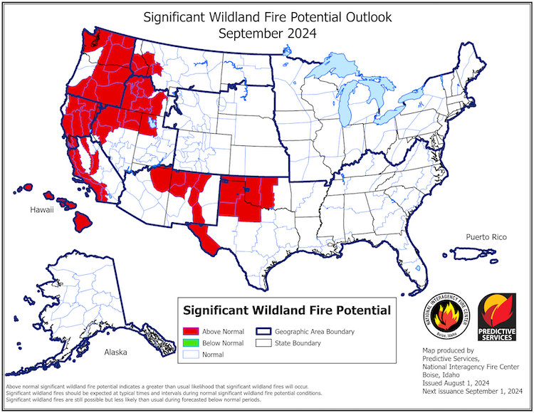
- The risk of wildfire is expected to remain high into the end of summer and early fall; the National Fire Preparedness Level is 4. The National Significant Wildland Fire Potential Outlook, released on August 1, 2024, indicates that fire potential will remain above-normal across most of the Pacific Northwest through September (Figure 8).
- The El Niño–Southern Oscillation (ENSO) is expected to remain in ENSO-neutral status for the next several months, with La Niña favored to emerge during September to November. La Niña tends to bring cooler, wetter winters in the Pacific Northwest.
Figure 6: 1-Month Precipitation and Temperature Outlook for September 2024
Key Takeaway: According to the National Weather Service Climate Prediction Center, temperatures are likely to be above normal for the Pacific Northwest, except in Washington. Most of the region has equal chances for above-, near-, or below-normal precipitation. Northwestern Washington is likely to receive above-normal precipitation during September 2024.
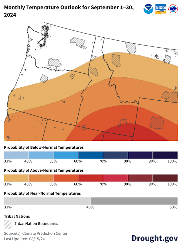
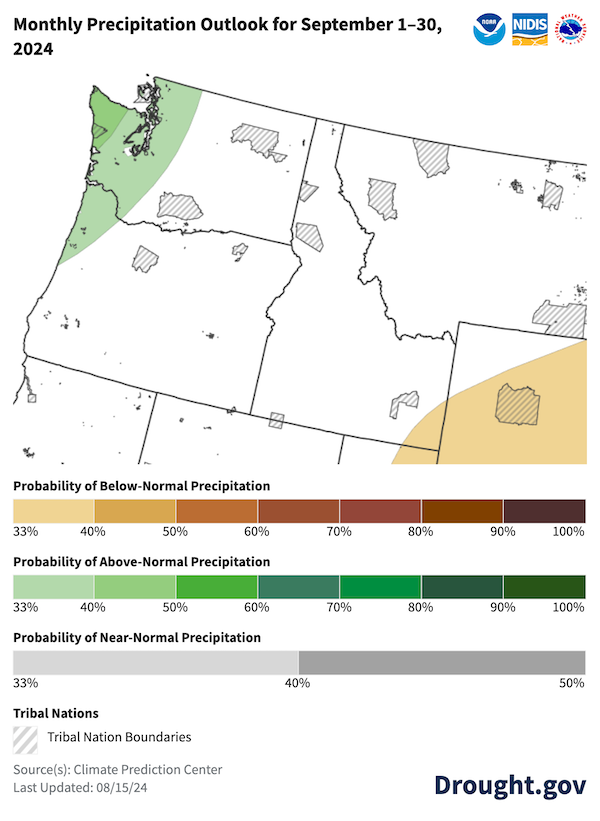
Figure 7: U.S. Seasonal (3-month) Drought Outlook
Key Takeaway: The National Weather Service Climate Prediction Center’s U.S. Seasonal Drought Outlook (valid August 15–November 30, 2024) indicates that drought severity and extent will improve or end in regions east of the Cascade Range in Washington and Oregon. Drought persistence is likely across southeastern Oregon, northern Idaho, and western Montana.
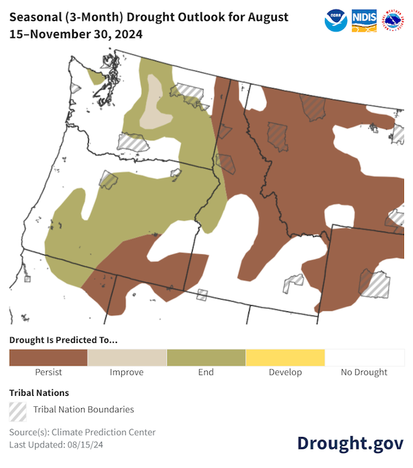
Figure 8: Significant Wildland Fire Potential Outlook for September 2024
Key Takeaway: Nearly all of the Pacific Northwest has significant (above-normal) wildland fire potential for September 2024. Western Oregon and far northern Idaho are at normal risk.
Resources
- Farm and Ranch Stress Assistance Network
- Register for the next Pacific Northwest Drought Early Warning System Webinar on Monday, October 28 at 11 a.m. PT.
- View more maps and data on Drought.gov's state pages:
- More local information is available from the following resources:
Prepared By
Jason Gerlich
Cooperative Institute for Research in Environmental Science (CIRES), NOAA’s National Integrated Drought Information System
Guillaume Mauger
Office of the Washington State Climatologist, University of Washington
Larry O’Neill
Oregon Climate Service, Oregon State University
Erica Fleishman
Oregon Climate Change Research Institute, Oregon State University
Caroline Mellor
Washington State Department of Ecology
This Drought Status Update is issued in partnership between the National Oceanic and Atmospheric Administration (NOAA) and Oregon Climate Change Research Institute, Washington State Department of Ecology, Office of the Washington State Climatologist, and Oregon Climate Service to communicate a potential area of concern for drought expansion and/or development within the Pacific Northwest based on recent conditions and the upcoming forecast. Thank you to the Idaho Climate Services, Idaho Department of Water Resources, NRCS, and the Oregon Water Resources Department for providing an assessment on impacts. NIDIS and its partners will issue future Drought Status Updates as conditions evolve.