Lack of rain in October led to rapidly expanding dry conditions in the Southeast.
Additional drought development and impacts are expected into early November, with uncertainty for the winter months ahead.
Key Points
- Much of the Southeast experienced little to no rain in the month of October, which drove expansion of dry conditions including in some areas that recently received substantial rainfall from Hurricanes Helene and Milton.
- A number of locations have over 30 days without any measurable rainfall and are on track to tie for their driest of ANY month on record dating back to the late 1800s.
- Above-normal temperatures, including near-record average high temperatures in some areas, have contributed to the drying out of soils.
- Agricultural agents in Alabama, Georgia, Tennessee, and the Florida panhandle are reporting quickly deteriorating conditions. Impacts include poor pastures leading to feeding hay to cattle and delays in fall and winter planting. Fire risk is increasing with several burn bans and restrictions in place. However, the dry weather has been beneficial for some late season harvesting.
- Streamflows for most of the region are in the normal range, which puts them in good shape heading into the dry recharge season. The exception is in those areas that have been dry longer and are currently experiencing drought, including Tennessee and Alabama, where many streams are experiencing below-normal flows with impacts to ecological systems and water supply.
- Additional drought development and impacts are likely into early November, as limited rainfall is forecast in the region for the next week, except for northern Alabama and western Tennessee. The week of November 7 may see a return to near-normal rainfall. More uncertainty exists for the winter months, but the expected weak La Niña pattern may increase the odds of below-normal precipitation for December thru February across Florida, Georgia, Alabama, and South Carolina.
Current Conditions: The Southeast Dries Out Quickly
This update is based on data available as of Thursday, October 31, 2024 at 8 a.m. ET. We acknowledge that conditions are evolving.
- Record-setting rainfall and flooding from Hurricane Helene in late September and Hurricane Milton in early October impacted parts of the Southeast.
- October was characterized by a record-setting lack of rainfall through much of the region, except for the Florida peninsula.
- As of October 30, the following locations have over 30 days without any measurable rainfall and are on track to tie for their driest of ANY month on record dating back to the late 1800s: Columbia, South Carolina; Augusta, Georgia; Macon, Georgia (1892-2024); Atlanta, Georgia (1878-2024; Muscle Shoals, Alabama (1893-2024); Huntsville, Alabama (1894-2024); Birmingham, Alabama (1895-2024).
- Asheville, North Carolina recorded its wettest month on record in September with 17.90 inches, and is on track to record its fourth driest October on record with just 0.03 inches through the 30th. This would mark the largest difference in precipitation between consecutive months on record (since 1869).
- Temperatures were largely above normal in October, with many locations experiencing their highest average maximum temperature on record.
- Abnormally Dry (D0) conditions now cover 57% of the Southeast, up from 19% only a week ago, as determined by the U.S. Drought Monitor.
- Moderate Drought (D1) is primarily constrained to Alabama, Tennessee, coastal South Carolina and Virginia, and northeast North Carolina, with some areas of Severe Drought (D2) in Alabama and Tennessee and one spot of Extreme Drought (D3) in Tennessee.
- This is the third period of rapid dryness in the Southeast over the past 7 months, with alternating periods of wet and dry conditions throughout the spring and summer.
- Additional information on current conditions are found here, or you can explore conditions at the state level.
Figure 1: U.S. Drought Monitor and Changes Since Last Week
Key Takeaway: There was a drastic expansion of abnormally dry conditions in the past week, as well as further degradation in those areas already in drought. This change reflects both the lack of precipitation and warm temperatures.
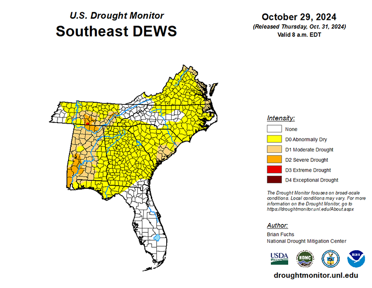
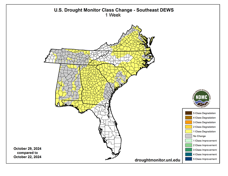
Figure 2: Rankings for Observed Total Precipitation in the Last Month
Key Takeaway: Much of the Southeast received little to no precipitation between September 28 - October 27, with the exception of the Florida peninsula and Virginia.
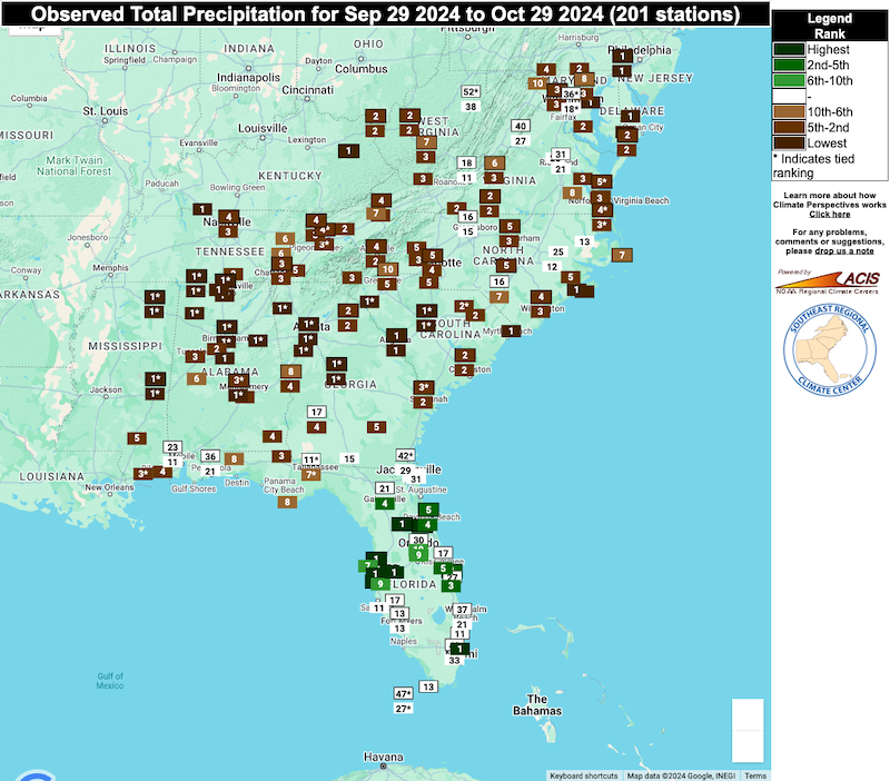
Figure 3: 30-Day Percent of Normal Precipitation for the Southeast
Key Takeaway: Much of the Southeast received little to no precipitation between September 28 - October 27, with the exception of the Florida peninsula and central Virginia.
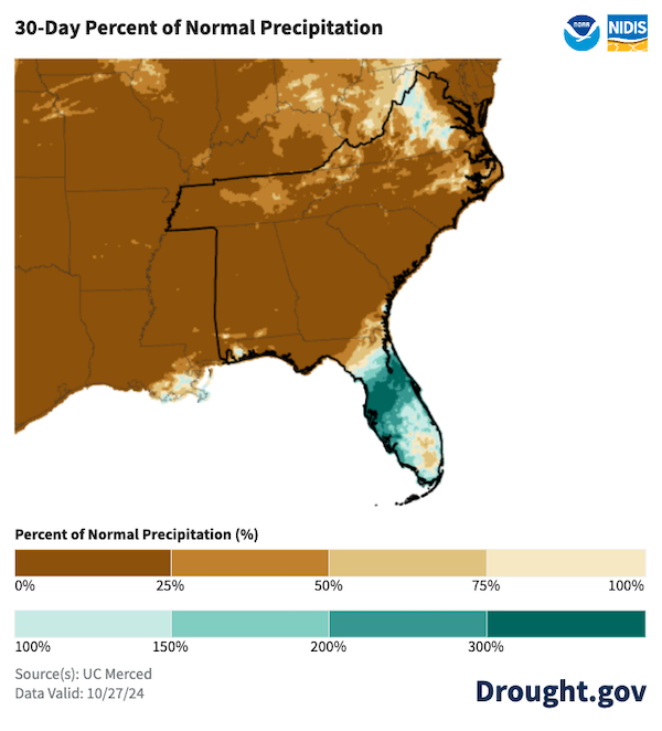
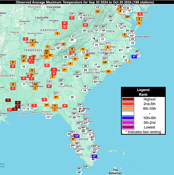
Figure 4: Rankings of Observed Average Maximum Temperature for the past month
Key Takeaway: Most of the region experienced normal- or above-normal temperatures in the past month, especially the interior locations, with parts of Alabama, Tennessee, and Georgia experiencing near-record high average maximum temperatures.
Drought Impacts to Agriculture, Forestry and Streamflow Levels
- Agricultural agents report quickly deteriorating conditions. Producers have not been able to plant some winter crops. Cattle producers are feeding hay to compensate for poor forage. Some irrigation ponds are drying up.
- Soils are cracking due to loss of soil moisture, and dust is degrading air quality. Peanut growers are expecting very low yields, especially those that do not irrigate. Beehives in Tennessee are losing weight due to lack of nectar in flowers and high temperatures.
- The warmer temperatures this October provided some benefits to crops that need a longer growing season and dry conditions have been beneficial to some late harvest crops.
- Wildfire risk is elevated in dry areas, with burn bans and restrictions going into effect in some areas. Falling foliage provides an increase in fire fuel as the region moves into its fall wildfire season. Tree damage following Hurricane’s Helene and Milton may further increase that risk due to the drying up of leaves and branches that can become fuel for a fire.
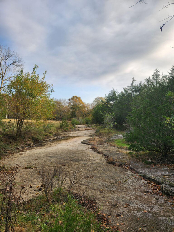
- Streamflow and groundwater measurements are largely still in good condition, except in the interior parts of the region where drought has persisted for a few months. For example, below normal flows have led to massive mussel die-offs, fish relocation, and a number of utility and water restrictions in middle Tennessee, along with completely dry ponds and creeks in many locations.
- Most reservoirs in the Southeast have not been as impacted due to extra moisture from recent tropical storms, but levels could decline if conditions persist.
- Report conditions and any drought impacts you see or hear via the Condition Monitoring Observer Reports from the National Drought Mitigation Center.
Figure 5: Lawn and Garden Moisture Index
Lack of rain significantly reduced soil moisture across most of the Southeast, except for parts of the Florida peninsula.
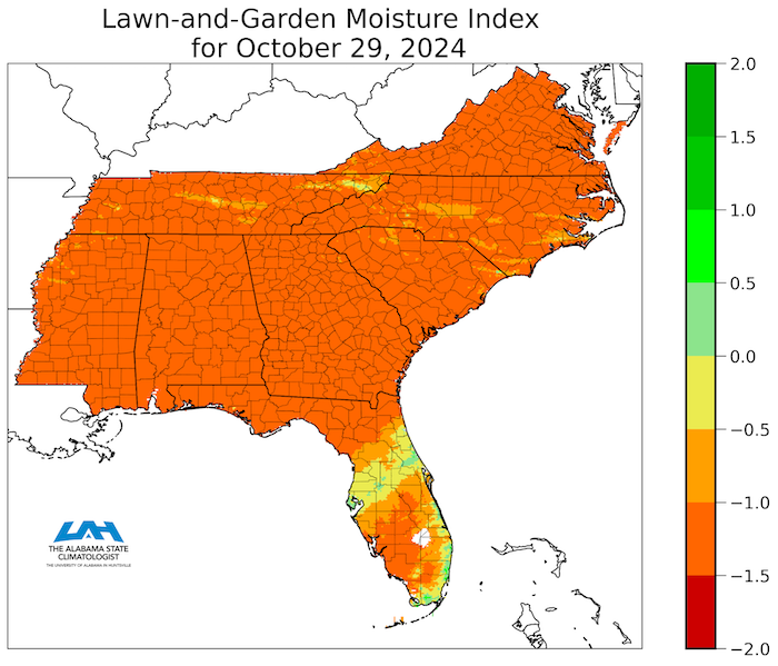
Figure 6: 28-Day Average Streamflow Conditions (Valid October 30, 2024)
Key Takeaway: Streamflow rates are currently near normal, except for central Florida (where high streamflows linger with water from Hurricane Milton) and Alabama (where there are below-normal conditions in areas that did not receive much rainfall from tropical activity).
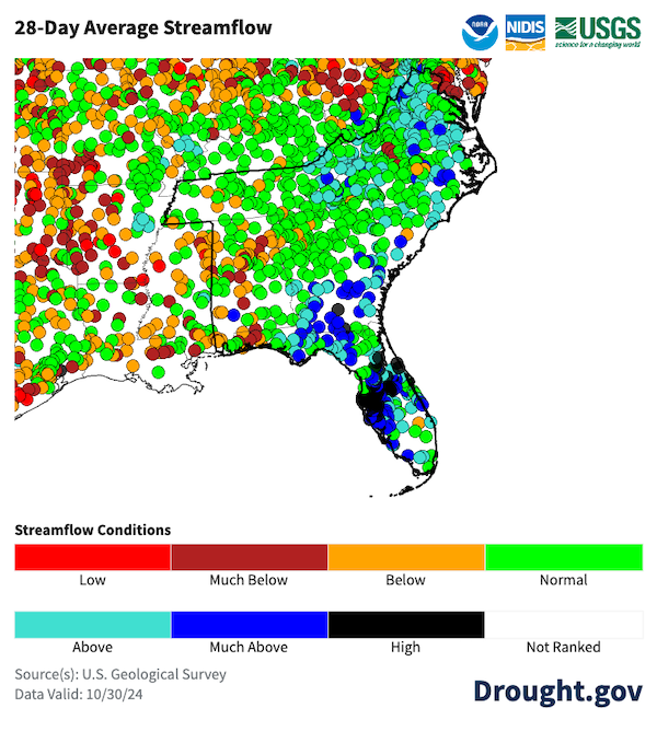
Photo 1: Poor Forage Conditions for Cattle
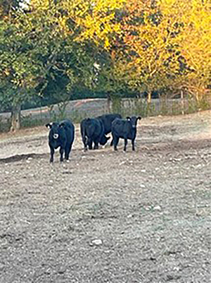
Photo 2: Dry Creek
Looking Ahead: No Near-Term Relief Expected, Uncertainty Around Winter Conditions
- Historically, October and November are the driest months for most of the Southeast except for the Florida peninsula.
- Little to no rain is expected over the next week, with the likely return of near- normal rainfall during the week of November 7.
- As dry conditions persist or continue into early November, drought is expected to develop and expand, at least in the near term.
- Wildfire risk and winter recharge may be of concern if this dry pattern does not change.
- The expected arrival of a weak La Niña may increase the likelihood of dry, warm conditions over the winter. See the latest La Niña status.
- Additional outlook and forecast information found on Drought.gov.
Figure 7: 7-Day Precipitation Forecast for the Next Week
Key Takeaway: Little to no rainfall is expected over the next week across most of the Southeast region.
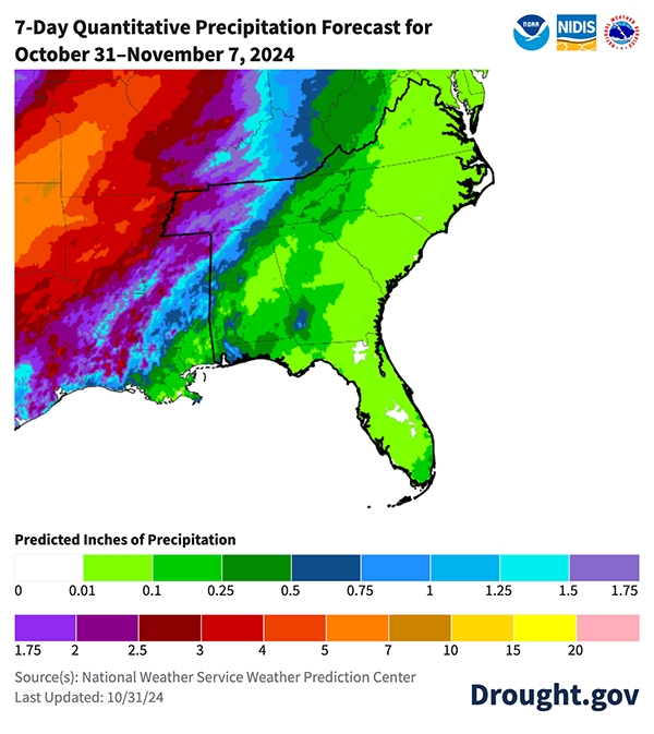
Figure 8: November 2024 Precipitation Outlook
Key Takeaway: There are no strong trends in precipitation over the next calendar month, with equal chances for above- or below-normal precipitation.
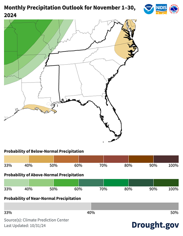
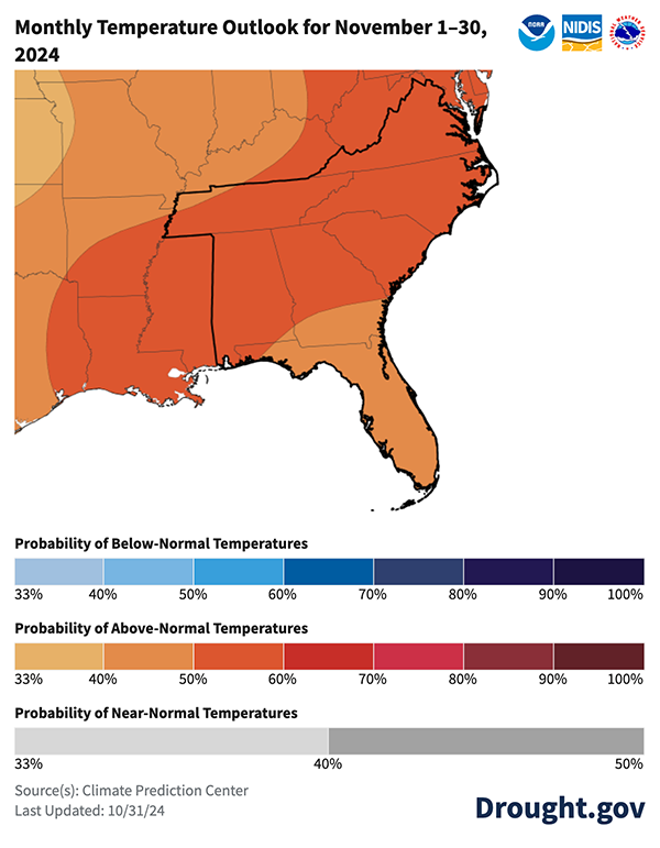
Figure 9: November 2024 Temperature Outlook
Key Takeaway: Temperatures are likely to be above normal across the region over the next month.
Resources
Drought.gov State Pages
State pages on Drought.gov provide a one-stop shop for tailored state drought information and resources for each state. Find your state here. You can also find county and city-level information on Drought.gov.
State Resources
- Alabama: ADECA Drought Planning and Management; Office of the Alabama State Climatologist; Alabama Drought Reach
- Florida: Florida Climate Center; Florida Weekly Drought Summary
- Georgia: Georgia EPD Drought Management; Office of the Georgia State Climatologist
- North Carolina: North Carolina Drought Management Advisory Council; North Carolina State Climate Office
- South Carolina: South Carolina Drought Page; South Carolina State Climatology Office
- Tennessee: Tennessee Weekly Drought Summaries; Tennessee Climate Office
- Virginia: Virginia DEQ Drought Page
Prepared By
Meredith Muth
NOAA's National Integrated Drought Information System
Victor Murphy and Chris Stachelski
NOAA’s National Weather Service
Chris Fuhrmann and William Schmitz
Southeast Regional Climate Center
Todd Hamill
NOAA’s National Weather Service Southeast River Forecast Center
This Drought Status Update is issued in partnership between the National Oceanic and Atmospheric Administration (NOAA) and partners to communicate a potential area of concern for drought expansion and/or development within the Southeast DEWS region based on recent conditions and the upcoming forecast. NIDIS and its partners will issue future Drought Status Updates as conditions evolve. Special thanks to state partners for their input including the State Climate Offices of Georgia and Tennessee, NWS Weather Forecast Offices in Virginia, University of Georgia, and the North Carolina Department of Environmental Quality.


