October was cool and wet for the Intermountain West. Wyoming and Colorado’s eastern plains missed out on most of that rain.
Key Points
- Most of the Intermountain West experienced a cool and wet October.
- Exceptional (D4) drought has dropped to less than 0.5% of the region, but persists in Utah and far northeastern Colorado
- The area in Severe (D2) to Exceptional (D4) drought is at its lowest in two years.
- NOAA’s Winter Outlook for December 2022–January 2023 shows a warmer-than-normal season ahead for much of the Intermountain West and dry for the Southwest.
Current U.S. Drought Monitor map for the Intermountain West Drought Early Warning System (DEWS) region with data valid for November 1, 2022. The U.S. Drought Monitor is updated each Thursday to show the location and intensity of drought across the country.
U.S. Drought Monitor Categories
Current U.S. Drought Monitor map for the Intermountain West Drought Early Warning System (DEWS) region with data valid for November 1, 2022. The U.S. Drought Monitor is updated each Thursday to show the location and intensity of drought across the country.
Current Drought Conditions and Outlook
U.S. Drought Monitor Conditions
- Exceptional (D4) drought persists in central Utah and northeastern Colorado.
- 11.02% of the region is experiencing Extreme (D3) drought or worse, the lowest amount since August 2020.
- Extreme (D3) drought conditions have been in place in this region since May 2020.
- Moderate (D1) or worse drought has been in the region since August 2009.
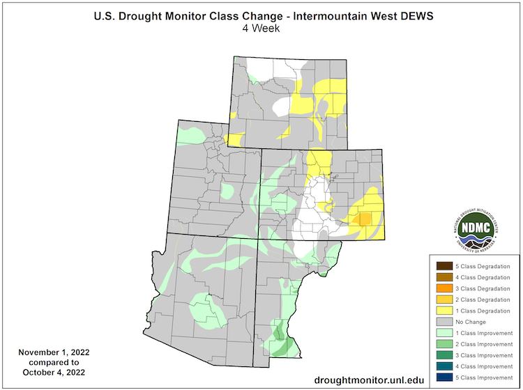
U.S. Drought Monitor 4-Week Change Map
October Temperatures and Precipitation
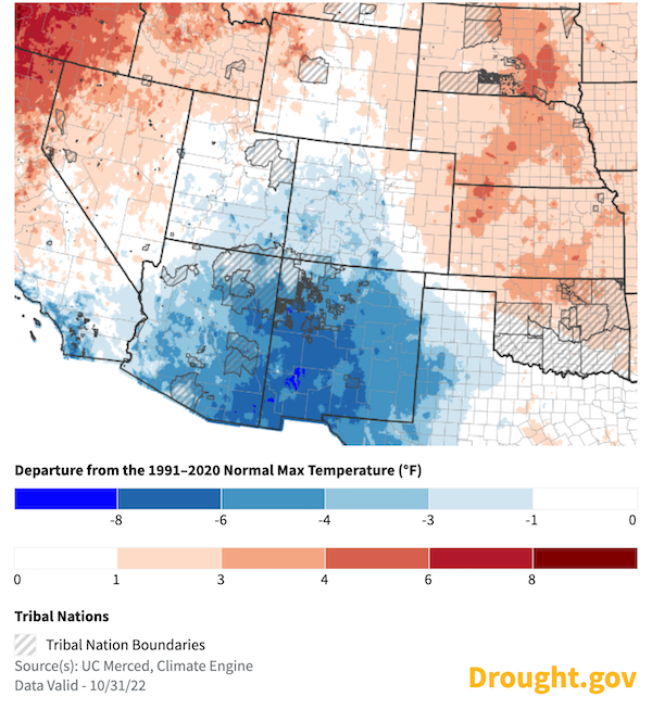
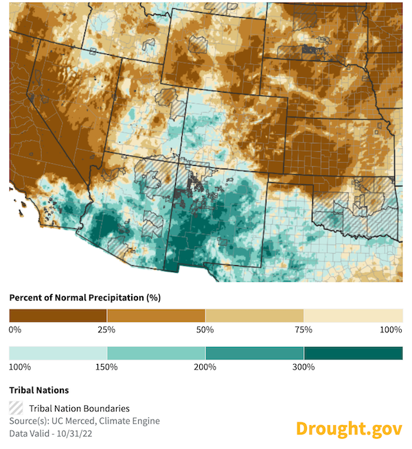
- Most of the Intermountain West saw a cool and wet October. A few exceptions include eastern Colorado and eastern Wyoming and parts of the Great Basin.
- October saw some parts of New Mexico and Arizona with monthly mean daily maximum temperatures more than 6 ºF below normal for the month.
30-Day Departure from Normal Maximum Temperature (°F)
30-Day Percent of Normal Precipitation
Forecasts and Seasonal Outlooks
November 2022
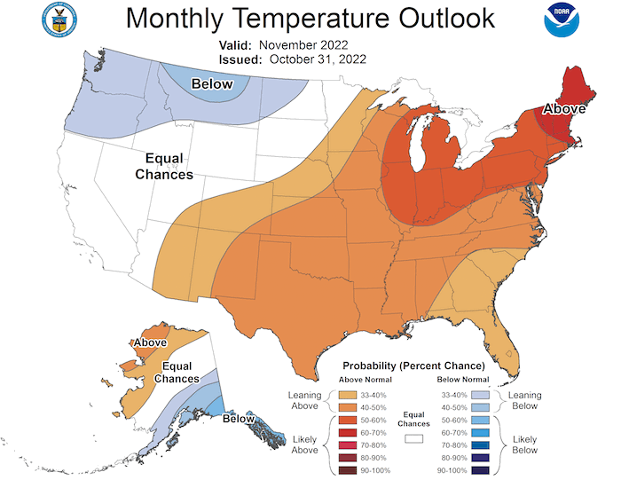
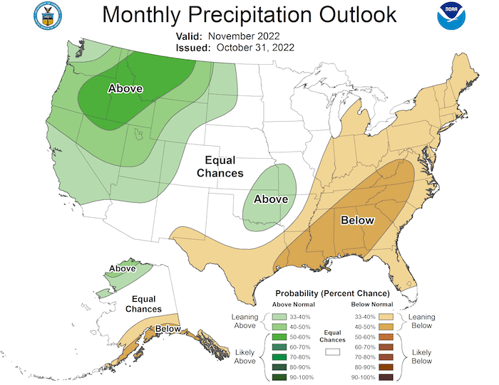
The Climate Prediction Center's monthly outlook for November shows:
- Increased temperatures for the month are likely across eastern New Mexico and southeastern Colorado.
- The monthly precipitation outlook for November shows above-normal precipitation is likely for northern Utah and western Wyoming, with slightly elevated chances for a wetter month for southern Utah, northern Arizona, and western Colorado.
November 2022 Temperature Outlook
November 2022 Precipitation Outlook
Winter Outlook: December 2022–February 2023
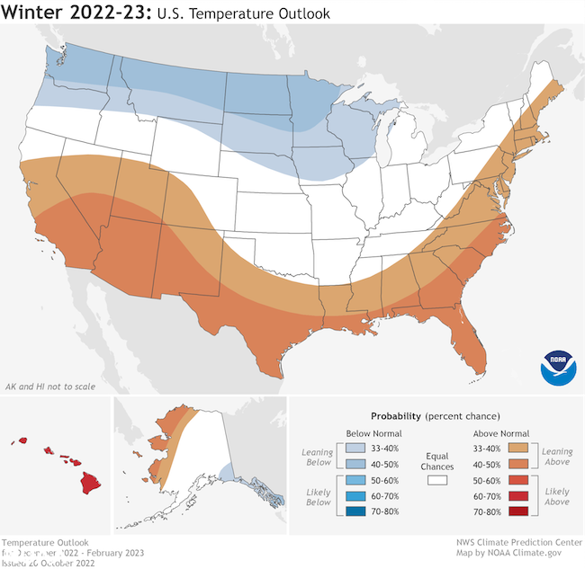
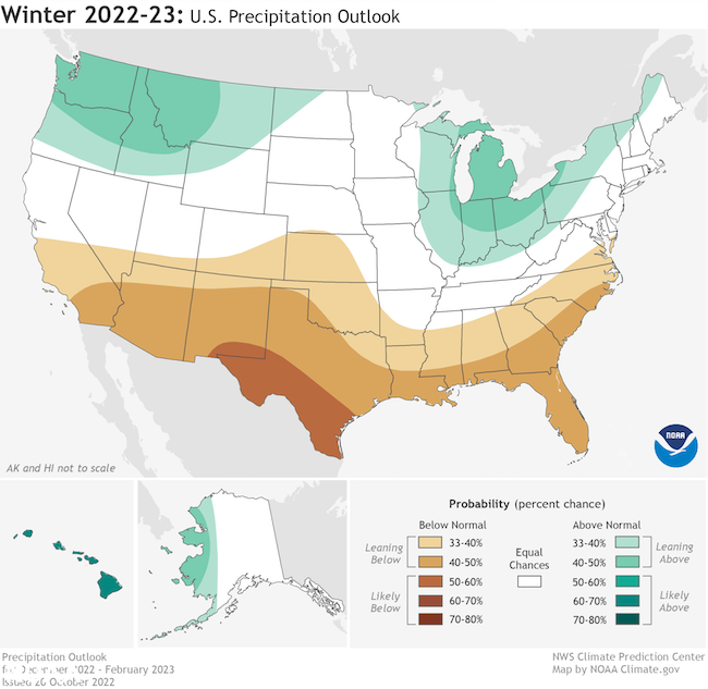
- The Climate Prediction Center's winter outlook for December 2022–February 2023 shows a warmer-than-normal season ahead for the Intermountain West, with the highest odds for above-normal temperatures in the Southwest.
- Lower-than-normal precipitation is more likely for Arizona and New Mexico, with equal chances elsewhere in the Intermountain West region.
Winter Temperature Outlook: December 2022–February 2023
Winter Precipitation Outlook: December 2022–February 2023
Seasonal Drought Outlook
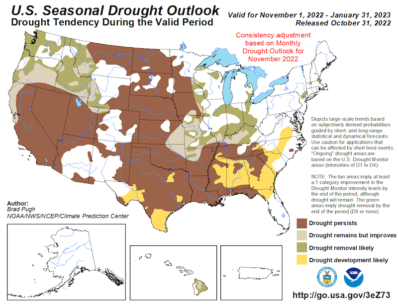
- The Climate Prediction Center's seasonal (3-month) drought outlook shows a relatively warm and dry season ahead for the Southwest with more favorable conditions for the rest of the Intermountain West.
- The seasonal drought outlook shows that short-term drought will likely persist for most of Utah, northern and western Arizona, and eastern New Mexico.
- Potential drought improvement is possible for far northern Utah and western Wyoming.
- Long-term drought will continue in the region.
November 1–January 31 Drought Outlook
La Niña Persists and May Impact Winter Weather
- One of the primary drivers of drought across the Southwest through the winter ahead will be a third consecutive year of a La Niña pattern in the Pacific.
- The latest CPC El Niño–Southern Oscillation (ENSO) discussion maintains a La Niña Advisory. There is a 75% chance of La Niña during the Northern Hemisphere winter (December–February) 2022–23, with a 54% chance for ENSO-neutral in February–April 2023.
- No two La Niña patterns are the same. For more information, please check out the NOAA ENSO blog.
State-Based Conditions and Impacts
Arizona
- After a wet monsoon season, precipitation continued to be in the forefront for Arizona. October precipitation was above average over much of the state; still, the average statewide October precipitation is only 0.87 inches. Western counties received below-average precipitation for the month.
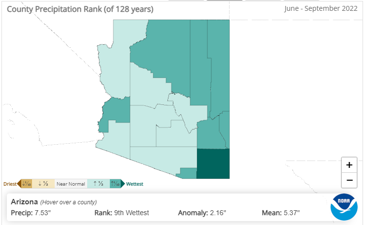
- Cochise County in the southeastern corner of Arizona experienced its wettest June–September on record, with 7.38 inches of precipitation. Cochise County also received the greatest number of lightning strikes for the state during the monsoon. The county is now showing tremendous grass and brush growth.
- Moderate (D1) drought only remains along the western, northern, and southeastern periphery of the state (34%), with small pockets (13%) of Severe (D2) drought embedded along these borders. The majority of the state (53%) resides in Abnormally Dry (D0) conditions that reach every county except Santa Cruz in southern Arizona.
June–September 2022 Precipitation Rankings, by Arizona County
Colorado
- Colorado experienced its 3rd warmest September on record (since 1895). October temperatures were closer to normal.
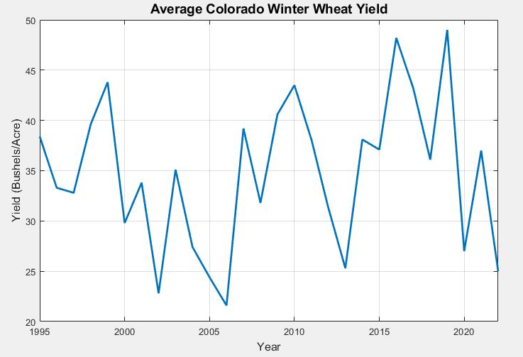
- The warm, dry summer has produced notable agricultural impacts. Colorado experienced its lowest average winter wheat yield since 2013.
- The monsoon season was above average for the Colorado high country, and antecedent soil moisture conditions prior to the snowpack season are the highest they have been in eight years.
- November tends to be a “wait and see” time frame as we transition from the growing season back into a new cold season and new snowpack.
Average Winter Wheat Yield by Year
New Mexico
- New Mexico has drought conditions ranging from no drought to exceptional drought (D4):
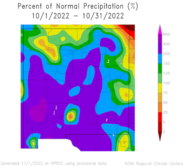
- The short-term drought conditions have improved dramatically in much of the state due in part to lingering moisture in October, with many parts of western and central New Mexico receiving as much as 400% of normal rainfall in the past 30 days.
- Despite this, there are some areas where extreme (D3) and exceptional drought (D4) remain, particularly in the eastern plains and far northeast of the state.
- Long-term effects of drought are still very much present despite a robust monsoon season.
- Short-term groundwater and vegetation signals are showing clear signs of improvement.
- Some long-term drought signals, such as surface water storage, are showing the effects of decades of drought. This is particularly true along the Rio Grande where Caballo and Elephant Butte reservoirs are at 11% and 6% of capacity, respectively.
New Mexico 30-Day Percent of Normal Precipitation
Utah
- After a slow start, a series of late-month storms dragged October’s precipitation back to near-normal for all but northwestern Utah, which ended just below normal for the month.
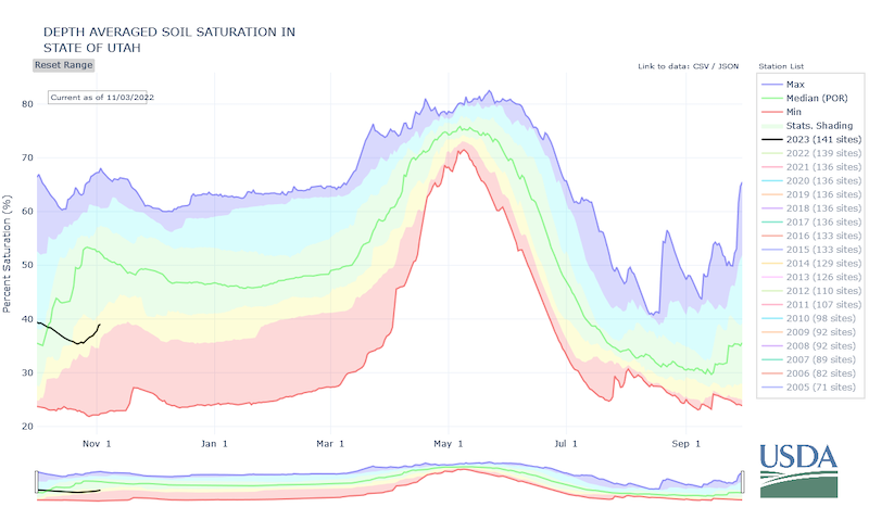
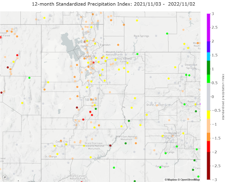
- The state’s ample soil moisture accumulated over the active monsoon season has been mostly lost and now resides at approximately 70%–80% of normal for most basins thanks to the dry September and early October; however, the recent storm activity has helped. Depth-average soil moisture and 12-month Standardized Precipitation Index values reflect the longer-term hydrologic drought and stand at roughly the 25th percentile for this time of year.
- Snowpack accumulation is off to an early start, but as we saw last year, such early success doesn’t necessarily correlate with overall seasonal precipitation expectations.
Statewide Depth-Average Soil Saturation
12-Month Standardized Precipitation Index (SPI): November 3, 2021–November 2, 2022
Wyoming
- Precipitation:
- The far northwest, some of central/north-central Wyoming, and parts of south-central Wyoming had median or above-median precipitation for the month of October.
- The remainder of Wyoming was at or below the 20th percentile for the month.
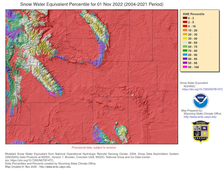
- Snowpack is starting to become established for the season.
- Soil Moisture:
- While improving, southeastern Wyoming is still experiencing soil moisture levels in the 10th or less percentile.
- Temperatures:
- Mean temperatures across the state for October were mostly within 3℉ of average. All but a few pockets in the southwest and south-central areas were above average.
- Parts of the north, along with Platte County, were 3℉ to 6℉ above average.
- Drought:
- The net change in drought status across the state for October saw mostly degradations or no change. D2 (Severe Drought) expanded in both the east and west, while areas with no drought at all in the central part of the state deteriorated to D0 or Abnormally Dry.
Wyoming Snow Water Equivalent Percentiles
For More Information
More local information is available from the following resources:
- Your state climatologist
- Your local National Weather Service office
- Western Water Assessment: Intermountain West Climate Dashboard
- Climate Assessment for the Southwest: Southwest Climate Outlook
In Case You Missed It
- October 11, 2022: Southwest Drought Briefing
Upcoming Events
- November 15, 2022, 12 p.m. MT: Southwest Drought Briefing
Prepared By
Joel Lisonbee
NOAA/National Integrated Drought Information System (NIDIS)
Erin Saffell
Arizona State Climatologist/Arizona State University
Peter Goble
Colorado Climate Center/Colorado State University
Jon Meyer
Utah Climate Center/Utah State University
Tony Bergantino
Water Resources Data System – Wyoming State Climate Office
This drought status update is issued in partnership between the National Oceanic and Atmospheric Administration (NOAA), and the offices of the state climatologist for Arizona, Colorado, New Mexico, Utah and Wyoming. The purpose of the update is to communicate a potential area of concern for drought expansion and/or development within the Intermountain West based on recent conditions and the upcoming forecast. NIDIS and its partners will issue future drought status updates as conditions evolve.


