For the latest forecasts and critical weather information, visit weather.gov.
No Drought Conditions Are Observed in Puerto Rico and the U.S. Virgin Islands.
View this drought update in Spanish.
Key Points
- Puerto Rico Conditions: Puerto Rico remains drought-free, although abnormally dry conditions remain along parts of the southern and northwest coast. A very wet November has been followed by relatively dry conditions since December 1, especially along the southern coast and northwest coast, which are shown by the latest U.S. Drought Monitor as being abnormally dry (D0).
- U.S. Virgin Islands Conditions: The end of the wet season in November was marked by slightly above-normal conditions, with both St. Croix and St. Thomas seeing about 6.5 inches of rain, or about 1 inch above normal. The wet November has been a blessing, with the winter season starting out quite dry at both St. Croix and St. Thomas. In St. Croix, Rohlsen Airport has seen only 2.45 inches of rain in December and January, less than 50% of the normal of 5.20 inches. St. Thomas has been even drier, with 2.13 inches of rain vs. a normal of 5.6 inches. Only the December/January time period in 1985/86 has been drier in 57 years of record. Accordingly, abnormally dry conditions (D0) are depicted on the U.S. Drought Monitor. St. John has remained unusually wet, with 24 of the first 30 days of January seeing measurable rainfall.
- Puerto Rico Impacts: There are reports of increasing dryness in some regions due to a lack of rain and strong winds. Streamflows are largely at normal levels.
- U.S. Virgin Islands Impacts: Wet-season rains helped to replenish water. However, farmers are starting to notice their soil drying out.
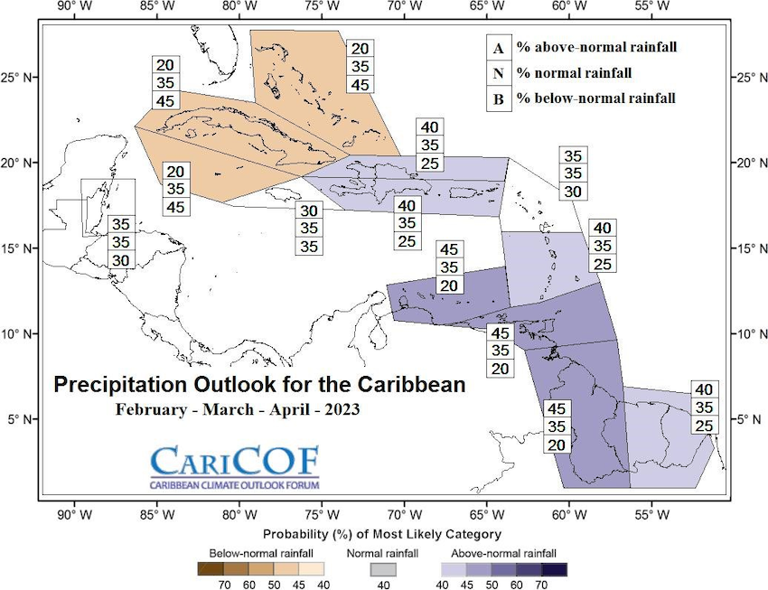
- Looking Ahead: The months of February–April are typically the driest of the year for Puerto Rico and the USVI. However, the precipitation outlooks indicate that there is only a 25% chance of drier-than-average conditions.
For weather information specific to your area, please monitor products issued by the National Weather Service in San Juan.
U.S. Drought Monitor map for Puerto Rico, as of January 31, 2023. The U.S. Drought Monitor is updated each Thursday to show the location and intensity of drought across the country.
U.S. Drought Monitor map for the U.S. Virgin Islands, as of January 31, 2023. The U.S. Drought Monitor is updated each Thursday to show the location and intensity of drought across the country.
U.S. Drought Monitor
D0 - Abnormally Dry
Abnormally Dry (D0) indicates a region that is going into or coming out of drought, according to the U.S. Drought Monitor. View typical impacts by state.
D1 – Moderate Drought
Moderate Drought (D1) is the first of four drought categories (D1–D4), according to the U.S. Drought Monitor. View typical impacts by state.
D2 – Severe Drought
Severe Drought (D2) is the second of four drought categories (D1–D4), according to the U.S. Drought Monitor. View typical impacts by state.
D3 – Extreme Drought
Extreme Drought (D3) is the third of four drought categories (D1–D4), according to the U.S. Drought Monitor. View typical impacts by state.
D4 – Exceptional Drought
Exceptional Drought (D4) is the most intense drought category, according to the U.S. Drought Monitor. View typical impacts by state.
U.S. Drought Monitor Categories
Abnormally Dry (D0)
Abnormally Dry (D0) indicates a region that is going into or coming out of drought. View typical impacts by state.
Moderate Drought (D1)
Moderate Drought (D1) is the first of four drought categories (D1–D4), according to the U.S. Drought Monitor. View typical impacts by state.
Severe Drought (D2)
Severe Drought (D2) is the second of four drought categories (D1–D4), according to the U.S. Drought Monitor. View typical impacts by state.
Extreme Drought (D3)
Extreme Drought (D3) is the third of four drought categories (D1–D4), according to the U.S. Drought Monitor. View typical impacts by state.
Exceptional Drought (D4)
Exceptional Drought (D4) is the most intense drought category, according to the U.S. Drought Monitor. View typical impacts by state.
U.S. Drought Monitor map for Puerto Rico, as of January 31, 2023. The U.S. Drought Monitor is updated each Thursday to show the location and intensity of drought across the country.
U.S. Drought Monitor map for the U.S. Virgin Islands, as of January 31, 2023. The U.S. Drought Monitor is updated each Thursday to show the location and intensity of drought across the country.
Current Conditions
Abnormally dry (D0) conditions are currently observed along the southern and northwest coasts of Puerto Rico, as well as St. Croix and St. Thomas. St. John and the remainder of Puerto Rico are drought-free. The months of November, December, and January have brought higher-than-normal rainfall to most of Puerto Rico, particularly the southern half of the island. Despite this activity, abnormally dry conditions prevail in the south of Puerto Rico, and soil saturation remains fairly low. Farmers are preparing for the dry season. The outlook for precipitation in the next three months is for a tilt towards average or slightly above-average rainfall, despite that these months are climatologically considered the driest months of the year.
Drought Conditions
- Puerto Rico: Abnormally dry conditions persist along portions of the southern coast and northwest coast.
- U.S. Virgin Islands: St. Thomas and St. Croix are considered “abnormally dry” while St. John has no drought or dryness.
Sector Impacts
General Conditions
- Puerto Rico: There are reports of increasing dryness in some regions due to lack of rain and strong winds. In Guánica, conditions are reportedly very dry, and measures are being taken to reduce the risk of forest fires in vulnerable areas.
- U.S. Virgin Islands: A wet fall offered improved conditions that have helped remove some lingering dryness, and vegetation is showing signs of bouncing back. The rainy season in December also helped groundwater levels to improve slightly. Currently, intermittent and sporadic rain is occurring but not saturating the soil. St. Thomas and St. Croix are starting to show signs of drying out. Farmers note that even with short, scattered showers, the wind and heat are causing evaporation of the precipitation before the soil fully saturates.
Agricultural Conditions
- Puerto Rico: Current agricultural conditions in Puerto Rico vary significantly from region to region. In Santa Isabel, the lack of substantial rains combined with strong winds is causing dryness on some agricultural lands. In Toa Alta, soils have maintained near saturation in January due to consistent rain and cloud cover. In Lajas, some rain has fallen, though most days have been dry. In Hormigueros, vegetation is showing signs of dry conditions.
- St. Thomas: Farmers in St. Thomas are reporting ponds are full—they have not been since 2015. High winds have impacted soil moisture; some areas are reporting daily wind gusts above 30 mph. Due to concerns over an early drought season, many are doing what they can to plan and prepare irrigation and water efficiency tools to better manage water as part of a longer-term mitigation and conservation plan. Many are using ground cover to conserve soil moisture. Specialty and row crop farmers are working to refine water usage plans in preparation for a drier season. Many are moving to drought-tolerant crops to keep production up while conserving water. Farmers are rotating foraging livestock to various areas as a way to increase access to feed. In addition, livestock farmers are also preparing for water and hay storage, in the event of future drought. VIDA reported they are in the process of procuring a new water truck for St. Thomas farmers in the Bordeaux and Dorothea areas.
- St. John: Row and specialty crop farmers in St. John are reporting they had intermittent heavy rain in December; otherwise, they report that it appears they are moving into the dry season. The winds are high, which is impacting soil moisture, and farmers are preparing for a long, hot season. Most are currently focusing on microgreens, fruit trees, and quick crops to keep production levels up. Large-scale farmers have access to an aquifer and wells on St. John.
- St. Croix: Farmers have not seen a lot of rain post-November and December. Many are reporting intermittent and sporadic showers. In planning for drought again this year, researchers and livestock farmers are working to plan for feed shortages due to a lack of grass during the hotter months. Ranchers are thinking about feed and looking at drought mitigation strategies to plan for vegetation distress that may require hay purchases. VIDA is now storing hay in preparation for drought. Poultry farmers report they are concerned about conditions moving into the warmer months due to the demand for increased egg production by consumers. Farmers who have poultry, including both broilers and/or egg production, have smaller numbers overall due to the fact they must collect water in containers or use cistern water to provide for them. Lastly, the VI Department of Agriculture on St. Croix reported they provided more than 343,710 gallons of water to farmers in December, and in January, they supplied more than 664,910 gallons to farmers.
Rainfall Trends
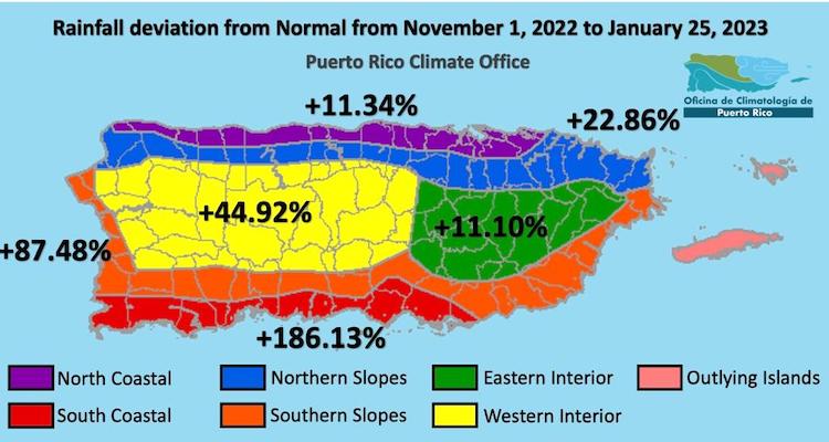
- Puerto Rico: November marks the end of the wet season. It was an abnormally wet month. Thus far, the drier months of December and January have been somewhat drier than normal. The end result is that the November 1 to late January time period has seen higher than normal rainfall (compared to 1980–2010 Climate Normals) across all climate zones in the Island. The surplus precipitation was most notable in the southern slopes and southern coastal zones with rainfall at 87% and 186% above normal, respectively (Figure 1).
- U.S. Virgin Islands: November marks the end of the wet season for the USVI, with normal rainfall between 5 and 6 inches. All 3 islands saw about 1 inch more than this amount. This was quite fortunate, as December–January rainfall on St.Croix and St. Thomas has only averaged 2–3 inches, or about 40% to 50% of normal. As such, both islands have been designated as being abnormally dry (D0) by the U.S. Drought Monitor. St. John has been an exception, with a very wet January. Measurable rainfall was observed on nearly 80% (24) of the days in January.
Soil Moisture Conditions in Puerto Rico
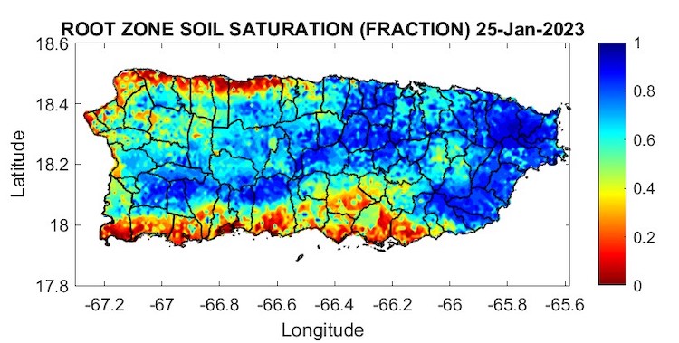
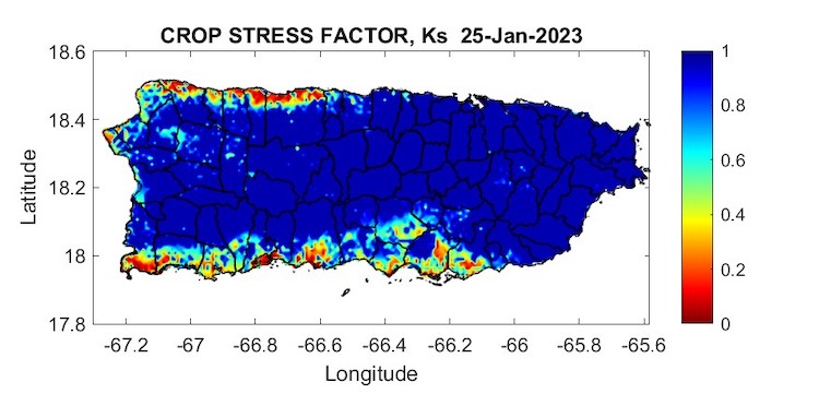
The latest soil moisture data from the Puerto Rico Agricultural Water Management (PRAGWATER) indicates a deterioration in saturation conditions, particularly in coastal regions of the north, south, and west. Parts of the interior and east of the island are still showing fairly high saturation. A high crop stress factor is present in the regions of poorest saturation (Figures 2 and 3).
Streamflow and Reservoir Conditions in Puerto Rico
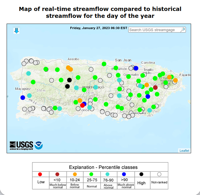
The real-time streamflow from the U.S. Geological Survey (USGS) river gauge network (Figure 4) indicates that, except for a few spots in the northern karst region and north of Ponce, most streams show normal or above-normal flows.
Outlooks
Rainfall Outlook
The climatology of Puerto Rico and the USVI indicates that the next three months (February–March–April) are the driest of the year. The 3-month extended forecast by the Caribbean Climate Outlook Forum (CariCOF) indicates that there is only a 25% chance of drier-than-average conditions, while there is a 75% chance of experiencing rainfall near or above the average amount for this period (Figure 5).
For More Information
- National Weather Service (NWS) Weather Forecast Office – San Juan: Climate and Drought Information
- NWS Drought Information Statements for Puerto Rico and the U.S. Caribbean
- Drought.gov:
- Caribbean Drought Bulletins. Caribbean Regional Climate Center, Caribbean Institute for Meteorology and Hydrology (CIMH), Barbados
- U.S. Department of Agriculture (USDA) Caribbean Climate Hub drought and disaster assistance resources for tropical forestry and agriculture
Prepared By
Héctor J. Jiménez
Office of Climatology, University of Puerto Rico
Odalys Martinez
National Weather Service Weather Forecast Office – San Juan
Meredith Muth
NOAA/National Integrated Drought Information System (NIDIS)
Victor Murphy
National Weather Service Southern Region
Christina Chanes, Gregory Guannel
University of Virgin Islands
William Gould, Nora Álvarez-Berríos, and Eva Holupchinski
USDA Caribbean Climate Hub, USFS International Institute of Tropical Forestry
Brad Rippey
USDA Office of the Chief Economist
Puerto Rico Reporting Input: Thanks to the Agricultural Extension Service, College of Agricultural Sciences, University of Puerto Rico-Mayaguez. Special thanks to Eric Harmsen, Professor of Agricultural Engineering UPR-M; Isela Ortiz, Southwest Soil and Water Conservation District Inc. (DCSAS), Darien Lopez, State Forester, Betzaida Ortiz-Carrión, AgroEmpresas Atabey and Ian Pagán Roig, Agroecological Project el Josco Bravo.
USVI Reporting Input: Several individuals contributed to this report, and we are acknowledging the following for their support, including the farming community across the USVI, UVI faculty, staff and collaborators of the UVI School of Agriculture, UVI Physics Program, UVI Etelman Observatory, UVI Agricultural Experiment Station, VI Department of Agriculture, as well as the USDA Office of the Chief Economist, National Parks Service in St. Croix, VI Department of Planning and Natural Resources, USDA Farm Service Agency, Coral Bay Community Council, and the many volunteer drought reporters and farmers from across the territory.
About This Report
This drought update is issued in partnership between the National Integrated Drought Information System (NIDIS), National Oceanic and Atmospheric Administration (NOAA) National Weather Service, the U.S. Department of Agriculture (USDA), and the University of the Virgin Islands. The purpose of the update is to communicate a potential area of concern for drought expansion and/or development within Puerto Rico and the U.S. Virgin Islands based on recent conditions and the upcoming three-month forecast.
NIDIS and its partners will issue these updates every two months. Subscribe for these U.S. Caribbean drought updates here.


