Next month’s Southeast Monthly Climate Webinar is on Tuesday, July 13 at 10 a.m. Eastern, with a special presentation on NOAA's "New Climate Normals." Register here for upcoming monthyl webinars.
Climate Conditions and Outlooks
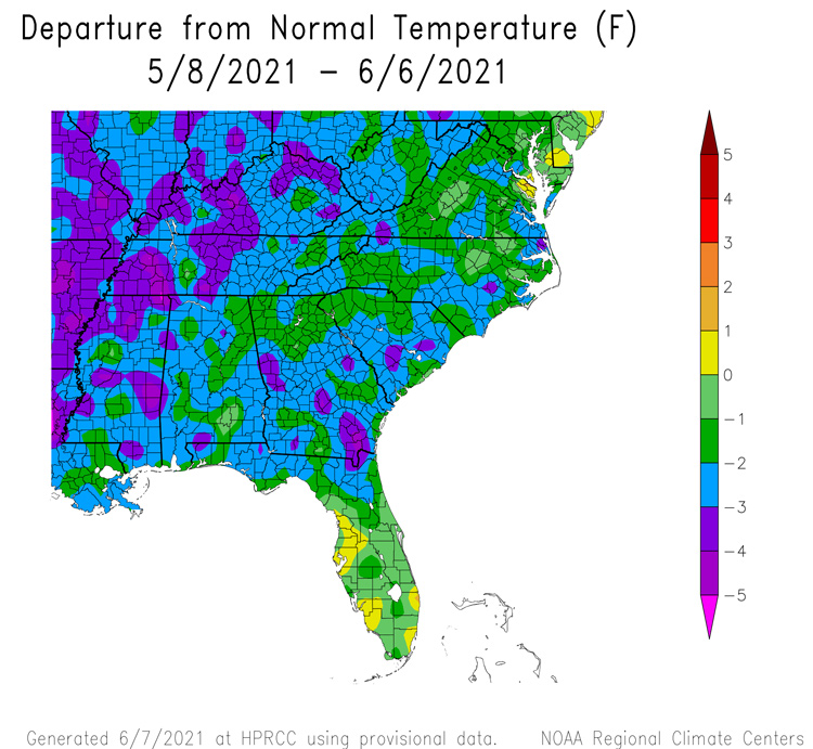
- May temperatures were slightly below average for most of Southeast region, with Florida and Puerto Rico near average.
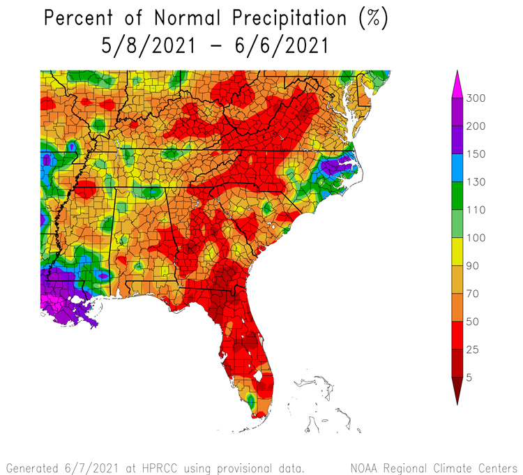
- May precipitation was above normal this past week for coastal North Carolina, and below normal for the rest of the region.
- May severe weather included hail in Greensboro, NC, an EF-1 tornado in York County, SC, and a lightning strike in Florida.
- The La Niña Advisory has ended, with neutral conditions continuing (67% chance June-August). The next update is on June 10.
- Tropical Update: Prepare now for Hurricane Season. Outlooks suggest another active season (see below).
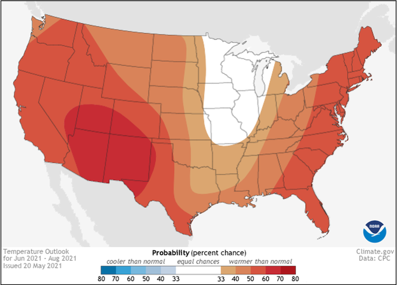
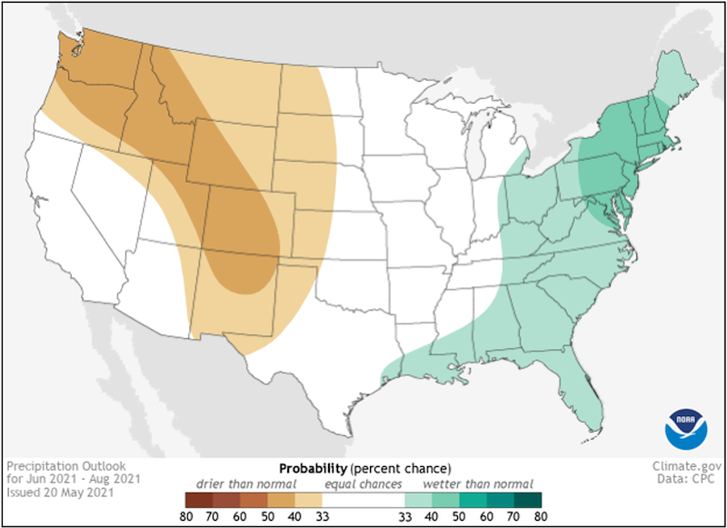
- Looking Ahead: The next 6-10 days have a higher probability of warmer temperatures and wetter conditions for most of the Southeast. The next three months will likely be warm and wet.
Current U.S. Drought Monitor map for the Southeast, as of June 1, 2021. The U.S. Drought Monitor (USDM) is updated each Thursday to show the location and intensity of drought across the country. Drought categories show experts’ assessments of conditions related to dryness and drought including observations of how much water is available in streams, lakes, and soils compared to usual for the same time of year.
Current U.S. Drought Monitor map for Puerto Rico, as of June 1, 2021. The U.S. Drought Monitor (USDM) is updated each Thursday to show the location and intensity of drought across the country. Drought categories show experts’ assessments of conditions related to dryness and drought including observations of how much water is available in streams, lakes, and soils compared to usual for the same time of year.
Current U.S. Drought Monitor map for the U.S. Virgin Islands, as of June 1, 2021. The U.S. Drought Monitor (USDM) is updated each Thursday to show the location and intensity of drought across the country. Drought categories show experts’ assessments of conditions related to dryness and drought including observations of how much water is available in streams, lakes, and soils compared to usual for the same time of year.
U.S. Drought Monitor Categories
Current U.S. Drought Monitor map for the Southeast, as of June 1, 2021. The U.S. Drought Monitor (USDM) is updated each Thursday to show the location and intensity of drought across the country. Drought categories show experts’ assessments of conditions related to dryness and drought including observations of how much water is available in streams, lakes, and soils compared to usual for the same time of year.
Current U.S. Drought Monitor map for Puerto Rico, as of June 1, 2021. The U.S. Drought Monitor (USDM) is updated each Thursday to show the location and intensity of drought across the country. Drought categories show experts’ assessments of conditions related to dryness and drought including observations of how much water is available in streams, lakes, and soils compared to usual for the same time of year.
Current U.S. Drought Monitor map for the U.S. Virgin Islands, as of June 1, 2021. The U.S. Drought Monitor (USDM) is updated each Thursday to show the location and intensity of drought across the country. Drought categories show experts’ assessments of conditions related to dryness and drought including observations of how much water is available in streams, lakes, and soils compared to usual for the same time of year.
Drought
- Short-term Severe Drought (D2) is present in eastern South Carolina, southeastern North Carolina, and the U.S. Virgin Islands. Moderate Drought (D1) is present in Virginia, North Carolina, South Carolina, Florida, and Puerto Rico.
- Looking Ahead: Drought removal is likely for the Carolinas.
Water Resources and Summer Flood Outlook
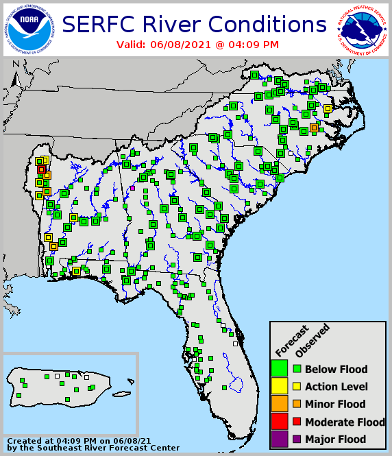
- Streamflows are generally near normal across the region with a general decline after a dry May across most of Southeast.
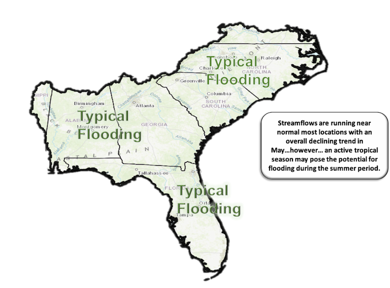
- Looking Ahead: One in nine Atlantic tropical storms produce widespread flooding in the Southeast region, so potentially expect 1–2 tropical storm flooding events in the Southeast through Fall. Overall, expect a typical number and magnitude of river floods this summer.
Agriculture Impact and Outlook
- Dry conditions in most of region have slowed the end of planting for cotton and peanuts, but helped farmers catch up on field work.
- Heavy irrigation is occurring where available.
- Dryland crops are hurting, and pastures and forage conditions are not good in most parts of the region.
- Impacts from April frosts are generally less severe than expected
- Looking Ahead: More rain the next week will be welcome but will increase disease pressure. Tropical activity appears to be starting up, which could cause heavy rains, clouds and cooler temperatures along the path, and dry conditions away from the center.
The 2021 Seasonal Atlantic Hurricane Outlook
- This will most likely be an above-normal season.
- The NOAA Atlantic Hurricane Outlook predicts 13-20 named storms, 6-10 hurricanes, and 3-5 major hurricanes
- Useful links:
 What Happened: Southeast Temperature
What Happened: Southeast Precipitation
Current Conditions: River Flood Status
Looking Ahead: Summer Flood Outlook
Looking Ahead: Seasonal Outlooks
Temperature Outlook: June-August 2021
Precipitation Outlook: June-August 2021
Acknowledgments
Webinar Speakers
- Sandra Rayne, Southeast Regional Climate Center
- Todd Hamill, National Weather Service Southeast River Forecast Center
- Pam Knox, University of Georgia
- Matthew Rosencrans, NOAA Climate Prediction Center
Relevant Regional Resources
Southeast Regional Climate Center (SERCC)
National Weather Service Southeast River Forecast Center (SERFC)
Streamflow Monitoring & Forecasting
National Weather Service Climate Prediction Center: Outlook Products
ACIS Climate Maps, High Plains Regional Climate Center
NOAA El Niño/Southern Oscillation (ENSO) Blog
Climate and Agriculture in the Southeast: Blog
Hurricane Preparedness
The Southeast Climate monthly webinar series is held on the second Tuesday of each month at 10:00 a.m. ET. This series is hosted by the Southeast Regional Climate Center, in partnership with the National Integrated Drought Information System (NIDIS) and the NOAA National Weather Service. These webinars provide the region with timely information on current and developing climate conditions such as drought, floods and tropical storms, as well as climatic events like El Niño and La Niña. Speakers may also discuss the impacts of these conditions on topics such as agriculture production, water resources, wildfires and ecosystems.
For webinar-related questions or suggestions, please contact Meredith Muth (meredith.f.muth@noaa.gov).
