Next month’s Southeast Monthly Climate Webinar is on Tuesday, August 10 at 10 a.m. Eastern, with a special presentation on "Heat Risk Tools for the Southeast." Register here for upcoming monthly webinars.
Climate Conditions and Outlooks
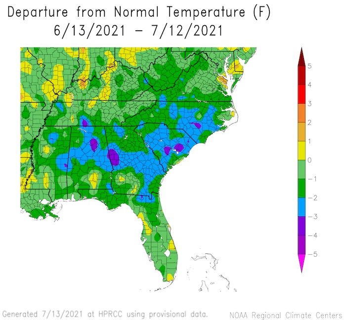
- June temperatures were near average for most of the Southeast region.
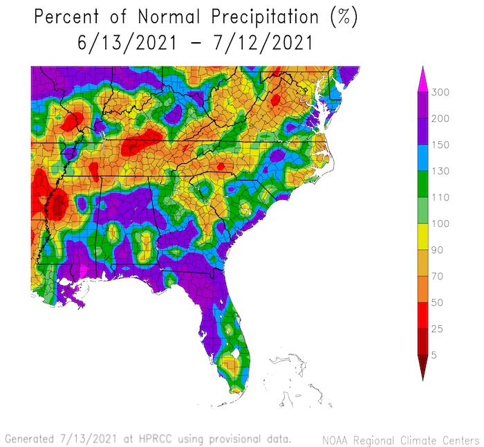
- June precipitation was variable due to summer thunderstorms and tropical systems.
- La Niña Watch: ENSO-neutral conditions are favored through summer and into fall (51% chance August–October), with La Niña potentially emerging during the September–November season and lasting through the 2021–22 winter (66% chance November–January).
- Tropical Update:
- Tropical storms Ana, Bill, Claudette, Danny
- Hurricane Elsa
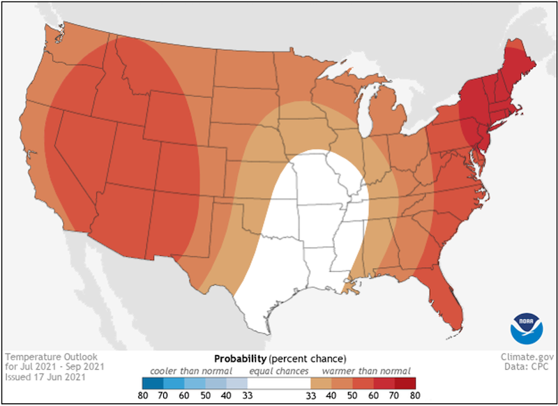
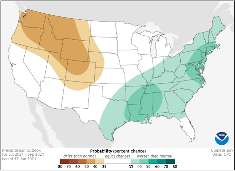
- Looking Ahead: According to the July 14–18 outlook, odds favor warmer temperatures for Virginia and North Carolina and drier conditions for the coastal Carolinas.
Current U.S. Drought Monitor map for the Southeast, as of July 6, 2021. The U.S. Drought Monitor (USDM) is updated each Thursday to show the location and intensity of drought across the country. Drought categories show experts’ assessments of conditions related to dryness and drought including observations of how much water is available in streams, lakes, and soils compared to usual for the same time of year.
Current U.S. Drought Monitor map for Puerto Rico, as of July 6, 2021. The U.S. Drought Monitor (USDM) is updated each Thursday to show the location and intensity of drought across the country. Drought categories show experts’ assessments of conditions related to dryness and drought including observations of how much water is available in streams, lakes, and soils compared to usual for the same time of year.
Current U.S. Drought Monitor map for the U.S. Virgin Islands, as of July 6, 2021. The U.S. Drought Monitor (USDM) is updated each Thursday to show the location and intensity of drought across the country. Drought categories show experts’ assessments of conditions related to dryness and drought including observations of how much water is available in streams, lakes, and soils compared to usual for the same time of year.
U.S. Drought Monitor Categories
Current U.S. Drought Monitor map for the Southeast, as of July 6, 2021. The U.S. Drought Monitor (USDM) is updated each Thursday to show the location and intensity of drought across the country. Drought categories show experts’ assessments of conditions related to dryness and drought including observations of how much water is available in streams, lakes, and soils compared to usual for the same time of year.
Current U.S. Drought Monitor map for Puerto Rico, as of July 6, 2021. The U.S. Drought Monitor (USDM) is updated each Thursday to show the location and intensity of drought across the country. Drought categories show experts’ assessments of conditions related to dryness and drought including observations of how much water is available in streams, lakes, and soils compared to usual for the same time of year.
Current U.S. Drought Monitor map for the U.S. Virgin Islands, as of July 6, 2021. The U.S. Drought Monitor (USDM) is updated each Thursday to show the location and intensity of drought across the country. Drought categories show experts’ assessments of conditions related to dryness and drought including observations of how much water is available in streams, lakes, and soils compared to usual for the same time of year.
Drought
- Abnormally Dry conditions (D0) are present in Virginia, the Carolinas, and Puerto Rico, with Moderate Drought (D1) at the Virginia–North Carolina border and southern Puerto Rico.
- Looking Ahead: Drought removal is likely.
Water Resources and Summer Flood Outlook
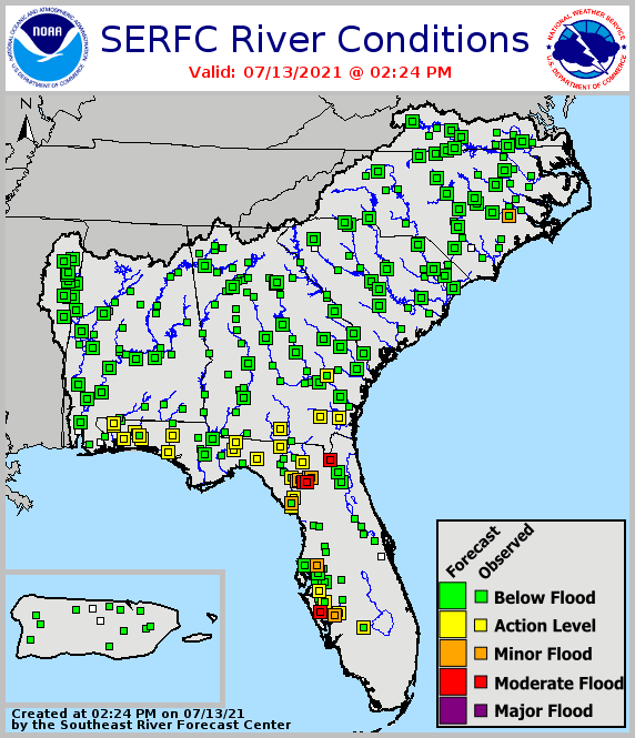
- Streamflows are above normal across Alabama, most of Florida, and parts of the Carolinas from Tropical Storm Claudette in June and, recently, Hurricane Elsa. Georgia streamflows are mostly near normal.
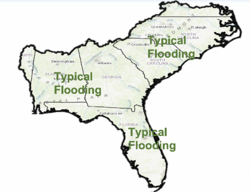
- Looking Ahead: The summer flood outlook calls for typical river flooding, which is fairly minimal/isolated from July to September. The exception is the Florida Peninsula, where magnitude and number go up with tropical and convective storm season.
- Looking Ahead: Flash flooding and headwater flooding will have the greatest risk through late summer in the Southeast. Tropical systems will also dictate the threat into autumn.
Agriculture Impact and Outlook
- The region did not experience too many adverse impacts from tropical storms, other than lots of rain and some locally severe weather.
- There is no sign of flash drought, although there are dry areas in central and western North Carolina and Virginia.
- Lots of disease pressure from fungal diseases and insect pests.
- Looking Ahead: Tropical activity is expected to be relatively quiet for the next few weeks. The current cycle of "rinse and repeat" is expected to occur for at least the next week.
New Climate Normals
- There are now almost 15,000 stations with precipitation normals and more than 7,300 stations with temperature normals.
- Warming from 1981–2010 to 1991–2020 is widespread but not ubiquitous across the conterminous U.S., either in geographic space or time of year, with recent cooling in the North Central U.S.
- Precipitation changes from 1981–2010 to 1991–2020 also vary considerably on a month-to-month basis, but are generally wetter in the Southeast and Central U.S.
What Happened: Southeast Temperature
 What Happened: Southeast Precipitation
Current Conditions: River Flood Status
Looking Ahead: Summer Flood Outlook
Looking Ahead: Seasonal Outlooks
Temperature Outlook: July–September 2021
Precipitation Outlook: July–September 2021
Acknowledgments
Webinar Speakers
- Sandra Rayne, Southeast Regional Climate Center
- Jeff Dobur, National Weather Service Southeast River Forecast Center
- Pam Knox, University of Georgia
- Michael Palecki, NOAA National Centers for Environmental Information
Relevant Regional Resources
Southeast Regional Climate Center (SERCC)
National Weather Service Southeast River Forecast Center (SERFC)
Streamflow Monitoring & Forecasting
National Weather Service Climate Prediction Center: Outlook Products
ACIS Climate Maps, High Plains Regional Climate Center
NOAA El Niño/Southern Oscillation (ENSO) Blog
Climate and Agriculture in the Southeast: Blog
Hurricane Preparedness
- National Hurricane Center
- Graphical Tropical Weather Outlook
- National Hurricane Preparedness Week
- National Hurricane Center Facebook page
- National Hurricane Center Twitter page
Climate Normals
The Southeast Climate monthly webinar series is held on the second Tuesday of each month at 10:00 a.m. ET. This series is hosted by the Southeast Regional Climate Center, in partnership with the National Integrated Drought Information System (NIDIS) and the NOAA National Weather Service. These webinars provide the region with timely information on current and developing climate conditions such as drought, floods and tropical storms, as well as climatic events like El Niño and La Niña. Speakers may also discuss the impacts of these conditions on topics such as agriculture production, water resources, wildfires and ecosystems.
For webinar-related questions or suggestions, please contact Meredith Muth (meredith.f.muth@noaa.gov).
