Next month’s Southeast Monthly Climate Webinar is on Tuesday, September 14 at 10 a.m. Eastern. Register here for upcoming monthly webinars.
Climate Conditions and Outlooks
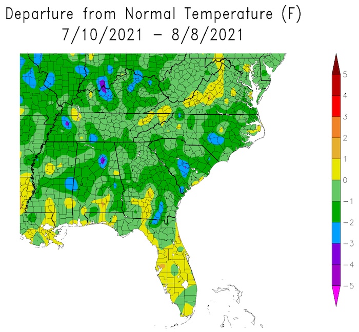
- Past temperatures: Near average for most of the Southeast region.
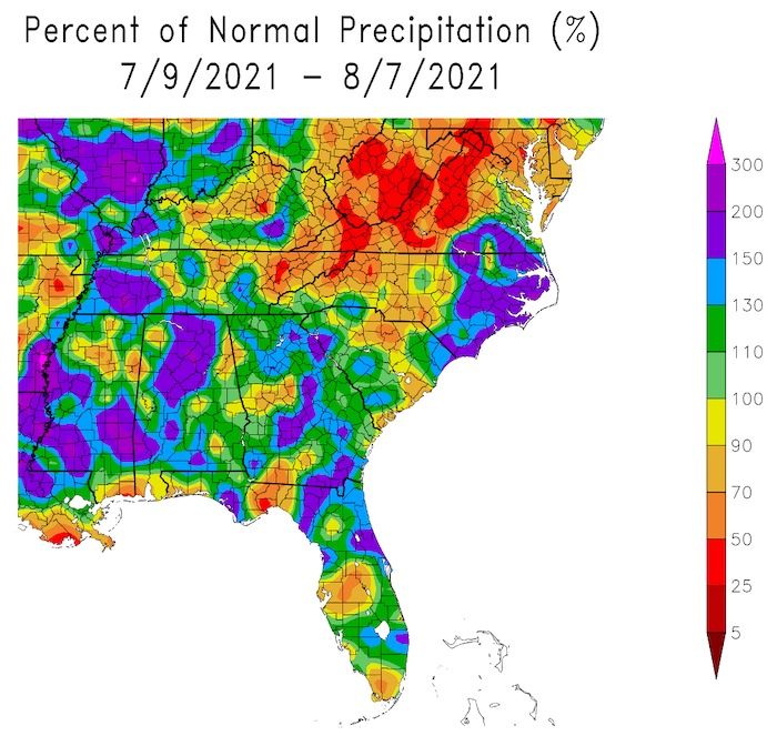
- Past precipitation: Variable due to summer thunderstorms and Hurricane Elsa.
- Tropical Weather: Hurricane Elsa brought rain and tornadoes to parts of the region in July.
- La Niña Watch: ENSO-neutral conditions are favored through summer and into fall (51% chance August–October), with La Niña potentially emerging during the September–November season and lasting through the 2021–22 winter (66% chance November–January). The next update is this Thursday.
- Looking ahead:
- Potential Tropical Cyclone Six is forecast to become Tropical Storm Fred as it moves over the northeastern Caribbean Sea today (Tuesday, August 10). Tropical storm conditions are expected in portions of the U.S. Virgin Islands and Puerto Rico beginning this afternoon, and in the Dominican Republic by Wednesday. The biggest concerns are heavy rainfall and flooding, especially across the eastern and southeastern portions of Puerto Rico.
- The updated Atlantic Hurricane Outlook continues to forecast an above-average season. Learn more in this webinar with the August Hurricane Update.
- August 14–18 outlook: There is a slight probability of warmer temperatures except where there are clouds, and slight probability of wetter conditions wherever the tropical moisture impacts the region.
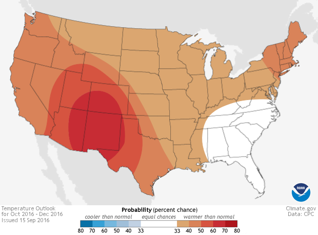
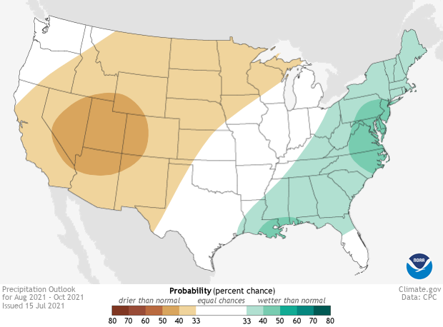
- Seasonal outlook: The next three months will likely be warm and wet depending on if/where tropical systems impact the region.
Current U.S. Drought Monitor map for the Southeast, as of August 3, 2021. The U.S. Drought Monitor (USDM) is updated each Thursday to show the location and intensity of drought across the country. Drought categories show experts’ assessments of conditions related to dryness and drought including observations of how much water is available in streams, lakes, and soils compared to usual for the same time of year.
Current U.S. Drought Monitor map for Puerto Rico, as of August 3, 2021. The U.S. Drought Monitor (USDM) is updated each Thursday to show the location and intensity of drought across the country. Drought categories show experts’ assessments of conditions related to dryness and drought including observations of how much water is available in streams, lakes, and soils compared to usual for the same time of year.
Current U.S. Drought Monitor map for the U.S. Virgin Islands, as of August 3, 2021. The U.S. Drought Monitor (USDM) is updated each Thursday to show the location and intensity of drought across the country. Drought categories show experts’ assessments of conditions related to dryness and drought including observations of how much water is available in streams, lakes, and soils compared to usual for the same time of year.
U.S. Drought Monitor Categories
Current U.S. Drought Monitor map for the Southeast, as of August 3, 2021. The U.S. Drought Monitor (USDM) is updated each Thursday to show the location and intensity of drought across the country. Drought categories show experts’ assessments of conditions related to dryness and drought including observations of how much water is available in streams, lakes, and soils compared to usual for the same time of year.
Current U.S. Drought Monitor map for Puerto Rico, as of August 3, 2021. The U.S. Drought Monitor (USDM) is updated each Thursday to show the location and intensity of drought across the country. Drought categories show experts’ assessments of conditions related to dryness and drought including observations of how much water is available in streams, lakes, and soils compared to usual for the same time of year.
Current U.S. Drought Monitor map for the U.S. Virgin Islands, as of August 3, 2021. The U.S. Drought Monitor (USDM) is updated each Thursday to show the location and intensity of drought across the country. Drought categories show experts’ assessments of conditions related to dryness and drought including observations of how much water is available in streams, lakes, and soils compared to usual for the same time of year.
Drought
- Abnormally dry conditions are present in Virginia, western North Carolina, and St. Thomas in the U.S. Virgin Islands (USVI). Moderate drought (D1) is present along the Virginia–West Virginia border, in southern Puerto Rico, and in St. John USVI. Severe Drought (D2) is present in St. Croix USVI.
- Looking ahead: Drought removal in the region is likely.
Water Resources and Summer Flood Outlook
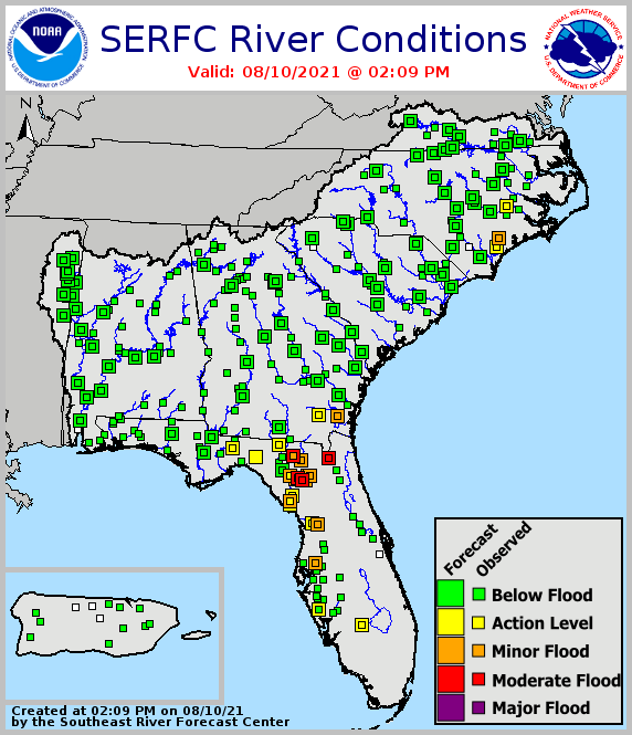
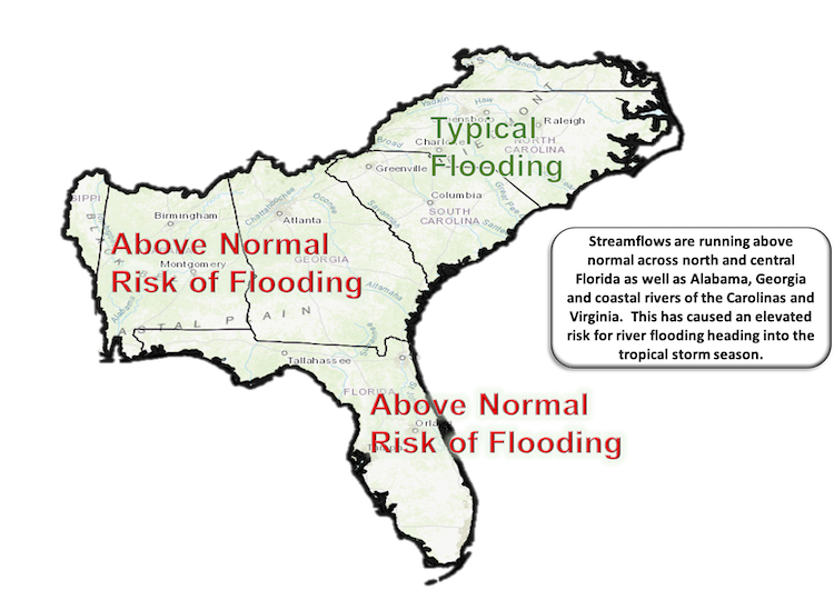
- Streamflows are above normal, especially across Florida, Georgia, and Alabama after a wet July.
- Reservoirs across the Southeast are near target pools, and some will begin heading to winter pools by the early autumn.
- Looking ahead: Overall, given a very wet July and current high streamflow, there is an elevated risk for river flooding this peak tropical season, especially in Florida, Alabama, and Georgia.
Agriculture Impact and Outlook
- There was not much impact from tropics last month, but that will change soon.
- Dry areas in central and western North Carolina and Virginia are still present, but there is limited drought.
- Cooler conditions are slowing the development of crops, reducing evapotranspiration (ET).
- There is lots of disease pressure from fungal diseases, less from insect pests.
- Looking ahead: A warmer and drier week should help farmers catch up on some field work, but it is not likely to last.
Heat Risk Tools: Wet Bulb Globe Temperature
- Wet bulb globe temperature (WBGT) is a heat stress measure that accounts for temperature, humidity, wind speed, and radiation.
- It is typically greatest in the interior coastal plain, especially northern Florida, southern Georgia, and Alabama.
- WBGT is typically highest in the early afternoon.
- It shows significant variations at a local scale that relate to wind speed (landscape openness).
- The web-based WBGT Forecast Tool for the Southeast is available!
- WBGT will be at dangerous levels over the next five days.
What Happened: Southeast Temperature
What Happened: Southeast Precipitation
Current Conditions: River Flood Status
Looking Ahead: Summer Flood Outlook
Looking Ahead: Seasonal Outlooks
Temperature Outlook: August–October 2021
Precipitation Outlook: August–October 2021
Acknowledgments
Webinar Speakers
- Sandra Rayne, Southeast Regional Climate Center
- Jeff Dobur, National Weather Service Southeast River Forecast Center
- Pam Knox, University of Georgia
- Chip Konrad, Southeast Regional Climate Center and the Carolinas Integrated Sciences & Assessments (CISA, a NOAA RISA team)
Relevant Regional Resources
Southeast Regional Climate Center (SERCC)
National Weather Service Southeast River Forecast Center (SERFC)
Streamflow Monitoring & Forecasting
National Weather Service Climate Prediction Center: Outlook Products
ACIS Climate Maps, High Plains Regional Climate Center
NOAA El Niño/Southern Oscillation (ENSO) Blog
Climate and Agriculture in the Southeast: Blog
Hurricane Preparedness
- National Hurricane Center
- Graphical Tropical Weather Outlook
- National Hurricane Preparedness Week
- National Hurricane Center Facebook page
- National Hurricane Center Twitter page
- USDA Hurricane Preparation and Recovery Guides
- Georgia Resident’s Handbook to Prepare for Natural Hazards
Heat Risk Tools
State Climate Offices
The Southeast Climate monthly webinar series is held on the second Tuesday of each month at 10:00 a.m. ET. This series is hosted by the Southeast Regional Climate Center, in partnership with the National Integrated Drought Information System (NIDIS) and the NOAA National Weather Service. These webinars provide the region with timely information on current and developing climate conditions such as drought, floods and tropical storms, as well as climatic events like El Niño and La Niña. Speakers may also discuss the impacts of these conditions on topics such as agriculture production, water resources, wildfires and ecosystems.
For webinar-related questions or suggestions, please contact Meredith Muth (meredith.f.muth@noaa.gov).


