For the latest forecasts and critical weather information, visit weather.gov.
Watch the September 14 webinar recording, which includes a special presentation on "Climate, Air Quality, and Health."
Register here for the October 12 Southeast Monthly Climate Webinar, including a presentation on "Hourly Precipitation Trends in the Southeast."
Key Points
- Tropical Activity: The active tropical storm season continues in the Atlantic with a number of tropical storms (Fred, Kate, Julian, Mindy, Nicholas) and hurricanes (Grace, Henri, Ida, Larry, Nicholas) this past month. Several of these, in particular Fred, Ida, and Mindy, had direct impacts across the Southeast region. The 2021 Atlantic hurricane season ends on November 30.
- ENSO Status: A La Niña Watch is currently in effect, and a transition from ENSO-neutral conditions to La Niña is favored in the next couple of months. This may lead to warmer and drier conditions going into the winter.
- Drought: Abnormally dry (D0) conditions exist in Virginia, North Carolina, and South Carolina, with moderate drought (D1) in in the U.S. Caribbean (Puerto Rico, parts of the Virgin Islands). Drought removal is likely, depending on tropical activity.
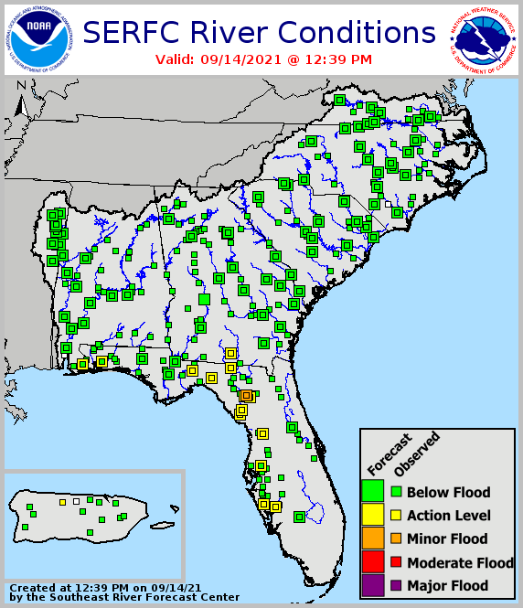
- Water Resources and Flooding: Streamflows remain above normal across parts of Mississippi, Alabama, Georgia, and north Florida. The potential for river flooding is higher across western sections of the region due to current above-normal streamflow conditions.
- Agriculture Impacts: Recent tropical systems caused limited impacts on the Southeast. However, rain has slowed some fieldwork, Ida affected transportation, and wet conditions have increased fungal disease pressure.
Current U.S. Drought Monitor map for the Southeast, as of September 7, 2021. The U.S. Drought Monitor (USDM) is updated each Thursday to show the location and intensity of drought across the country. Drought categories show experts’ assessments of conditions related to dryness and drought including observations of how much water is available in streams, lakes, and soils compared to usual for the same time of year.
Current U.S. Drought Monitor map for Puerto Rico, as of September 7, 2021. The U.S. Drought Monitor (USDM) is updated each Thursday to show the location and intensity of drought across the country. Drought categories show experts’ assessments of conditions related to dryness and drought including observations of how much water is available in streams, lakes, and soils compared to usual for the same time of year.
Current U.S. Drought Monitor map for the U.S. Virgin Islands, as of September 7, 2021. The U.S. Drought Monitor (USDM) is updated each Thursday to show the location and intensity of drought across the country. Drought categories show experts’ assessments of conditions related to dryness and drought including observations of how much water is available in streams, lakes, and soils compared to usual for the same time of year.
U.S. Drought Monitor Categories
Current U.S. Drought Monitor map for the Southeast, as of September 7, 2021. The U.S. Drought Monitor (USDM) is updated each Thursday to show the location and intensity of drought across the country. Drought categories show experts’ assessments of conditions related to dryness and drought including observations of how much water is available in streams, lakes, and soils compared to usual for the same time of year.
Current U.S. Drought Monitor map for Puerto Rico, as of September 7, 2021. The U.S. Drought Monitor (USDM) is updated each Thursday to show the location and intensity of drought across the country. Drought categories show experts’ assessments of conditions related to dryness and drought including observations of how much water is available in streams, lakes, and soils compared to usual for the same time of year.
Current U.S. Drought Monitor map for the U.S. Virgin Islands, as of September 7, 2021. The U.S. Drought Monitor (USDM) is updated each Thursday to show the location and intensity of drought across the country. Drought categories show experts’ assessments of conditions related to dryness and drought including observations of how much water is available in streams, lakes, and soils compared to usual for the same time of year.
Climate Conditions
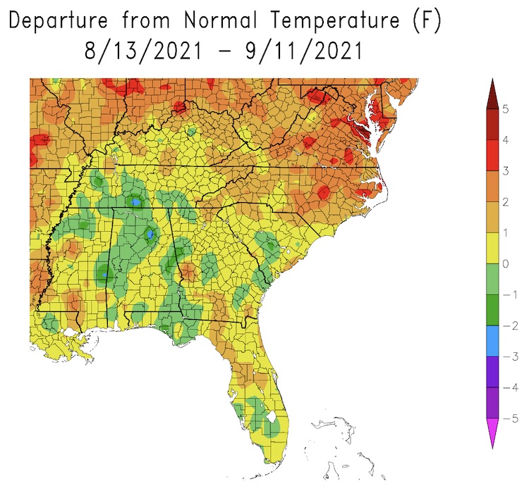
- Past month’s temperatures: Temperatures were above average for Virginia, North Carolina, and Puerto Rico, and near average for rest of Southeast region.
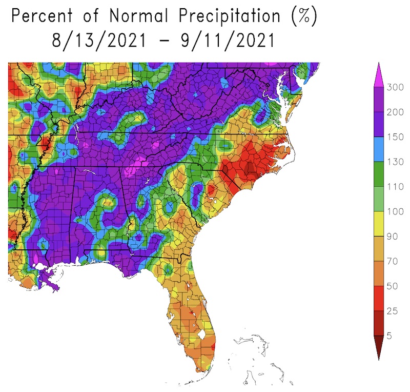
- Past month’s precipitation: Precipitation was variable due to summer thunderstorms and tropical systems, with mostly above-average precipitation to the west and below-average to the east.
- Summer season: The Southeast saw above-average precipitation and near-average mean temperatures, with below-average maximum temperatures and above average minimum temperatures.
- Tropical Storms: Fred, Kate, Julian, Mindy
- Hurricanes: Grace, Henri, Ida, Larry, Nicholas
- La Niña Watch: A transition from ENSO-neutral conditions to La Niña is favored in the next couple of months, with a 70%–80% chance of La Niña in the Northern Hemisphere during the winter season of 2021–22.
What Happened: Southeast Temperature
What Happened: Southeast Precipitation
Drought
- Abnormally dry (D0) conditions exist in Virginia, North Carolina, South Carolina, and Puerto Rico, with moderate drought (D1) in southern Puerto Rico and parts of the Virgin Islands.
- Looking ahead: Drought removal is likely.
Water Resources and Flooding
- Above-normal streamflows continue across parts of Mississippi, Alabama, Georgia, and north Florida. Streamflows are normal elsewhere.
- Reservoirs across the Southeast are near target pools, and some are heading to winter pools for the early autumn.
- Water resources remain adequate across the Southeast.
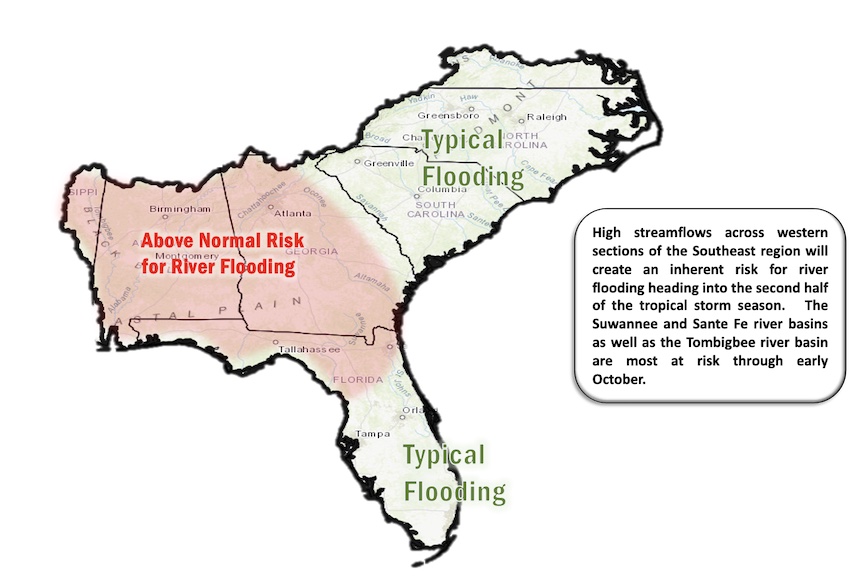
- Looking ahead: River flood potential has a heightened risk across western sections of the region due to current above-normal streamflow conditions.
Current Conditions: River Flood Status
Looking Ahead: September–November Flood Outlook
Agriculture Impact and Outlook
- Tropical systems Fred, Ida, and Mindy caused limited impacts on Southeast. However, rain has slowed some fieldwork, and Ida affected grain transportation, affecting markets.
- Dry areas in central and western North Carolina and Virginia still persist, but there is no drought yet.
- Lots of disease pressure from fungal diseases, less from insect pests.
- Looking ahead: Farmers will have to watch for dry periods and tropical storms as conditions are still favorable for daily showers.
Looking Ahead: Climate Outlooks
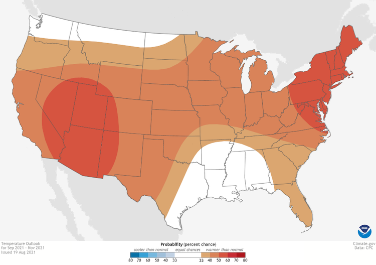
- September 18–22: Odds favor warmer temperatures, with a probability of wetter conditions wherever the tropical moisture impacts the region.
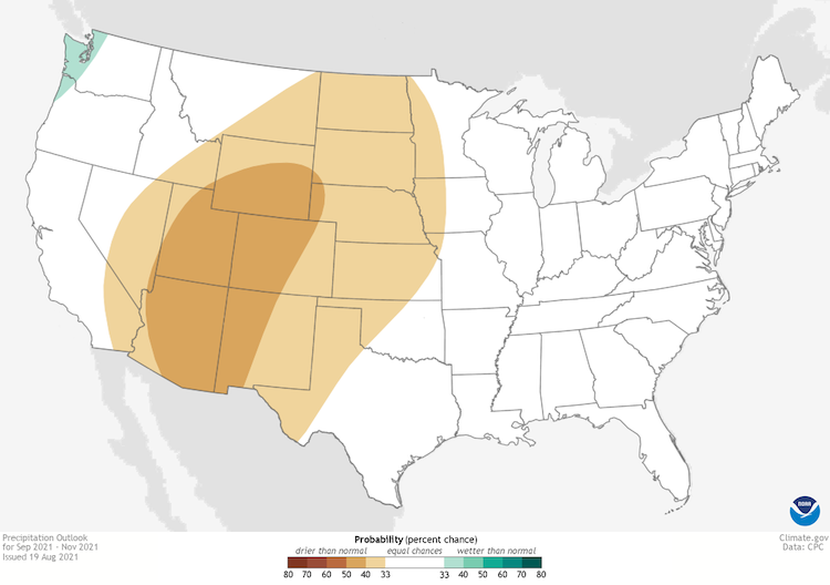
- Next three months: It will likely be warm, with equal chances of warmer or cooler conditions in Alabama, and equal chances of wetter or drier conditions depending on where tropical activity impacts the region.
Temperature Outlook: September–November 2021
Precipitation Outlook: September–November 2021
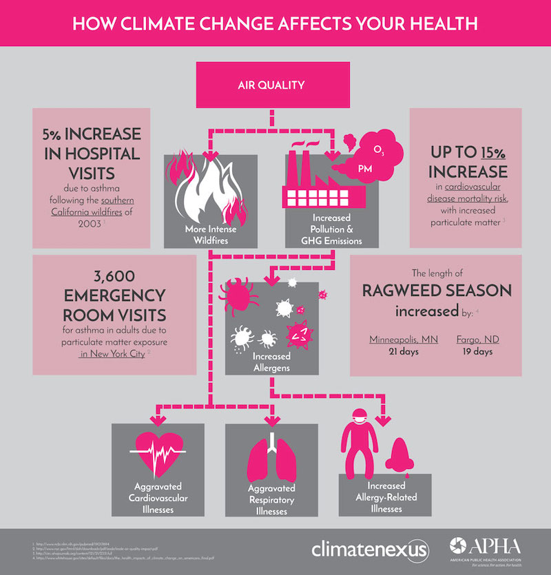
Special Presentation: Climate, Air Quality, and Health
- Poor air quality can have a negative effect on health.
- There is a climate change—air quality—health connection.
- The State of Georgia Climate Office, in collaboration with Georgia Tech and the Alabama Department of Environmental Management, issues daily Ozone/PM2.5 forecasts for Atlanta, Columbus, and Macon.
- The Ambient Monitoring Program of Environmental Protection Division's Air Protection Branch consistently monitors atmospheric pollutants across the state and provides special analysis when needed.
- For more information, see:
- Nyasha Dunkley, Georgia Deputy State Climatologist, nyasha.dunkley@dnr.ga.gov
- Office of the Georgia State Climatologist within the Environmental Protection Division
Acknowledgments
Webinar Speakers
- Sandra Rayne, Southeast Regional Climate Center
- Todd Hamill, National Weather Service Southeast River Forecast Center
- Pam Knox, University of Georgia
- Nyasha Dunkley, Georgia EPD and State Climate Office
- Meredith Muth, NOAA National Integrated Drought Information System
Relevant Regional Resources
Southeast Regional Climate Center (SERCC)
National Weather Service Southeast River Forecast Center (SERFC)
U.S. Geological Survey Streamflow Monitoring & Forecasting
National Weather Service Climate Prediction Center: Outlook Products
ACIS Climate Maps, High Plains Regional Climate Center
NOAA El Niño/Southern Oscillation (ENSO) Blog
Climate and Agriculture in the Southeast: Blog
Hurricane Preparedness
- National Hurricane Center
- Graphical Tropical Weather Outlook
- National Hurricane Preparedness Week
- National Hurricane Center Facebook page
- National Hurricane Center Twitter page
- USDA Hurricane Preparation and Recovery Guides
- Georgia Resident’s Handbook to Prepare for Natural Hazards
State Climate Offices
The Southeast Climate monthly webinar series is held on the second Tuesday of each month at 10:00 a.m. ET. This series is hosted by the Southeast Regional Climate Center, in partnership with the National Integrated Drought Information System (NIDIS) and the NOAA National Weather Service. These webinars provide the region with timely information on current and developing climate conditions such as drought, floods and tropical storms, as well as climatic events like El Niño and La Niña. Speakers may also discuss the impacts of these conditions on topics such as agriculture production, water resources, wildfires and ecosystems.
For webinar-related questions or suggestions, please contact Meredith Muth (meredith.f.muth@noaa.gov).


