Watch the November 9 webinar recording. Register here for the December 14 Southeast Climate Webinar, including a presentation on "El Niño-Southern Oscillation (ENSO) and the Southeast."
The active 2021 Atlantic Tropical season is coming to a close. Flooding in the region is minimal, and drought is starting to expand along the eastern seaboard. The current La Niña is expected to bring warmer and drier conditions across the region. Enjoy the remainder of the fall foliage in the Appalachian mountains!
Key Points
- Tropical Activity: This past month has been quiet, and no storm activity is expected to impact the Southeast at this time. The 2021 Atlantic hurricane season ends on November 30.
- El Niño-Southern Oscillation (ENSO) Status: La Niña conditions have developed and are expected to continue into the early spring. The next official ENSO update is on November 11. An ongoing La Niña may lead to warmer and drier conditions going into the winter. Learn more information here.
- Drought: Drought has expanded along the eastern seaboard region, with moderate drought (D1 according to the U.S. Drought Monitor) in parts of North Carolina, South Carolina, Puerto Rico, and St. Croix. Abnormally dry (D0) conditions have also expanded in Virginia, North Carolina, and South Carolina. Outlooks suggest that drought will persist, and development is likely in Georgia and Florida
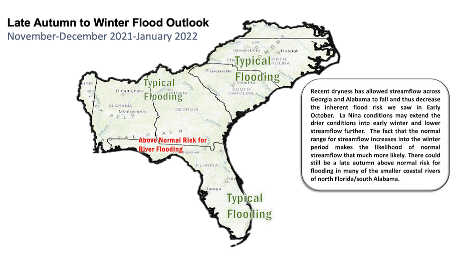
- Water Resources and Flooding: Recent dryness has allowed streamflow across Georgia and Alabama to fall and thus decrease the inherent flood risk we saw in early October. Near normal streamflows continue across most of the Southeast. Reservoirs across the Southeast are near target pools and many have begun their decline to winter pools. There could still be a late autumn above-normal risk for flooding in many of the smaller coastal rivers of north Florida/south Alabama. Learn more information here.
- Agriculture Impacts: Dry weeks have allowed fieldwork, planting, and harvest to catch up, and this is likely to continue for the next week or two. There is a slow increase of dry conditions across much of the region, but it is not a major threat to crops at this point. Frost is likely to end the growing season for many northern farmers this coming weekend, while southern areas look safe so far.
Current U.S. Drought Monitor map for the Southeast, as of November 2, 2021. The U.S. Drought Monitor (USDM) is updated each Thursday to show the location and intensity of drought across the country. Drought categories show experts’ assessments of conditions related to dryness and drought including observations of how much water is available in streams, lakes, and soils compared to usual for the same time of year.
Current U.S. Drought Monitor map for Puerto Rico, as of November 2, 2021. The U.S. Drought Monitor (USDM) is updated each Thursday to show the location and intensity of drought across the country. Drought categories show experts’ assessments of conditions related to dryness and drought including observations of how much water is available in streams, lakes, and soils compared to usual for the same time of year.
Current U.S. Drought Monitor map for the U.S. Virgin Islands, as of November 2, 2021. The U.S. Drought Monitor (USDM) is updated each Thursday to show the location and intensity of drought across the country. Drought categories show experts’ assessments of conditions related to dryness and drought including observations of how much water is available in streams, lakes, and soils compared to usual for the same time of year.
U.S. Drought Monitor Categories
Current U.S. Drought Monitor map for the Southeast, as of November 2, 2021. The U.S. Drought Monitor (USDM) is updated each Thursday to show the location and intensity of drought across the country. Drought categories show experts’ assessments of conditions related to dryness and drought including observations of how much water is available in streams, lakes, and soils compared to usual for the same time of year.
Current U.S. Drought Monitor map for Puerto Rico, as of November 2, 2021. The U.S. Drought Monitor (USDM) is updated each Thursday to show the location and intensity of drought across the country. Drought categories show experts’ assessments of conditions related to dryness and drought including observations of how much water is available in streams, lakes, and soils compared to usual for the same time of year.
Current U.S. Drought Monitor map for the U.S. Virgin Islands, as of November 2, 2021. The U.S. Drought Monitor (USDM) is updated each Thursday to show the location and intensity of drought across the country. Drought categories show experts’ assessments of conditions related to dryness and drought including observations of how much water is available in streams, lakes, and soils compared to usual for the same time of year.
Climate Conditions
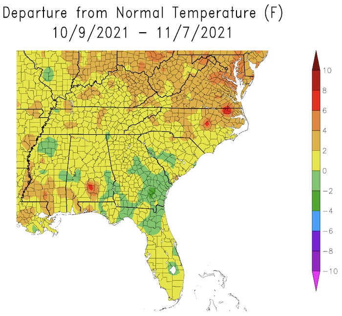
- Last Month’s Temperatures: Overall, it was a warm October. Temperatures were above average for Virginia, North Carolina, and Puerto Rico and near average for the rest of the Southeast region.
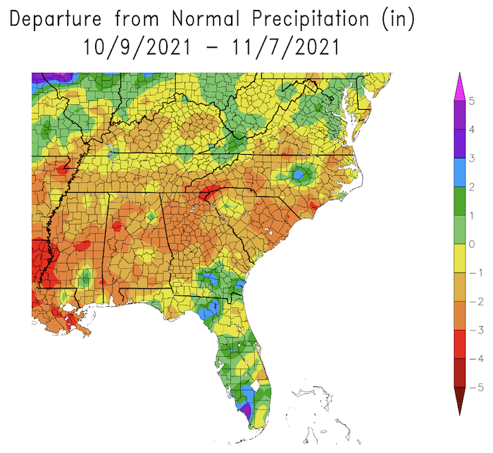
- Last Month’s Precipitation: There were pockets of above-average precipitation, but precipitation was below average for most of the region.
- Tropical activity was low in the Atlantic last month.
- La Niña Advisory: La Niña conditions have developed and are expected to continue with an 87% chance of La Niña in December 2021–February 2022. The next update is Thursday November 11.
- Looking Ahead – October 13-17: There is a greater probability of cooler temperatures, and a probability of drier conditions except in eastern Virginia and North Carolina.
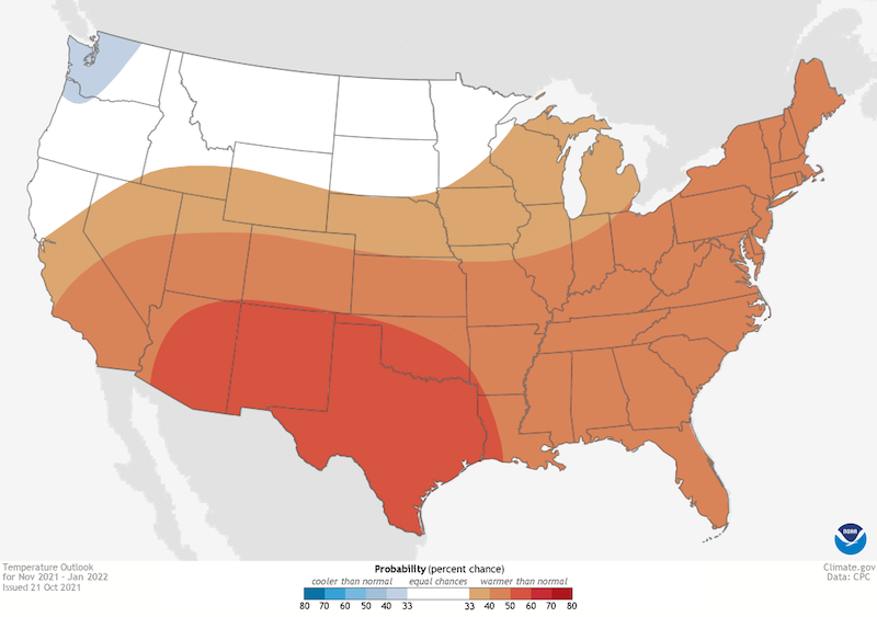
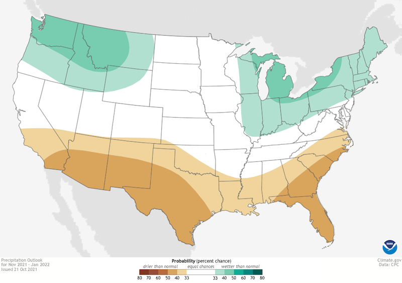
- Looking Ahead – Next Three Months: The next three months will likely be war. Odds favor equal chances of wetter or drier conditions in Virginia, with the probability of drier conditions elsewhere, a typical La Niña pattern for winter.
Southeast Temperature: October 9–November 7, 2021
Southeast Precipitation: October 9–November 7, 2021
Temperature Outlook: November 2021–January 2022
Precipitation Outlook: November 2021–January 2022
Drought
- Moderate drought (D1) is present in parts of North Carolina, South Carolina, Puerto Rico and St. Croix. Abnormally dry (D0) conditions are present in North Carolina, South Carolina, Georgia, Florida, Puerto Rico, and St. Thomas.
- Looking ahead: Drought persists, and development is likely in Georgia and Florida.
Water Resources and Flooding
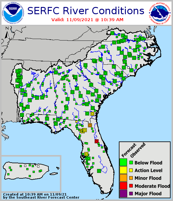
- Near-normal streamflows continue across most of the Southeast, with the exception of above-normal streamflows in southern Alabama, south Georgia, and north Florida. Spotty below-normal streamflow has been more evident across North Carolina and southern Virginia.
- Reservoirs across the Southeast are near target pools, and many have begun their decline to winter pools.
- Water resources remain adequate across the Southeast.
Current Conditions: River Flood Status
Looking Ahead: November–January Flood Outlook
Agriculture Impact and Outlook
- Dry weeks have allowed fieldwork, planting, and harvest to catch up, and this is likely to continue for next week or two.
- There is a slow increase of dry conditions, but it is not a major threat to crops at this time.
- Looking ahead: Frost is likely to end the growing season for many northern farmers this coming weekend, while southern areas look safe so far. The tropical season is likely over.
Special Presentation: Getting a Feel for Your Community’s Climate Future
This presentation by LuAnn Dahlman at the NOAA Climate Program Office provided an overview of several updated web-based tools that help visualize and communicate how climate conditions may change at a local level. These include:
- U.S. Climate Resilience Toolkit: Information to help climate champions recognize climate-related risks and find ways to reduce that risk.
- Southeast region under the Climate Resilience Toolkit: Plain-language narratives describing urban, rural, water, and ecosystems impacts of our changing climate, and ideas for building resilience to changing conditions.
- Climate Explorer: Downscaled climate projections for every county in the United States. Compare conditions from late last century to projections for upcoming decades.
- Introductory version of the Climate Explorer: Useful information to build your confidence in demonstrating the tool should you decide to encourage others to explore their past, present, and future climate conditions.
- Recently updated Climate.gov: Timely information on climate-related topics, maps & data (focused on a general audience rather than researchers), and resources for teaching (from elementary school through college).
For questions or additional information on the above products, contact LuAnn Dahlman.
Report Prepared By
- Meredith Muth, NOAA National Integrated Drought Information System
- Sandra Rayne, Southeast Regional Climate Center
- Jeff Dobur, National Weather Service Southeast River Forecast Center
- Pam Knox, University of Georgia
Additional Resources
Regional Products
- Southeast Regional Climate Center (SERCC)
- SERCC Southeast Region Monthly Climate Reports
- National Weather Service Southeast River Forecast Center (SERFC)
- U.S. Geological Survey Streamflow Monitoring & Forecasting
- National Weather Service Climate Prediction Center: Outlook Products
- ACIS Climate Maps, High Plains Regional Climate Center
- NOAA El Niño/Southern Oscillation (ENSO) Blog
- Climate and Agriculture in the Southeast: Blog
Hurricane Preparedness
- National Hurricane Center
- Graphical Tropical Weather Outlook
- National Hurricane Preparedness Week
- National Hurricane Center Facebook page
- National Hurricane Center Twitter page
- USDA Hurricane Preparation and Recovery Guides
State Climate Offices
The Southeast Climate monthly webinar series is held on the second Tuesday of each month at 10:00 a.m. ET. This series is hosted by the Southeast Regional Climate Center, in partnership with the National Integrated Drought Information System (NIDIS) and the NOAA National Weather Service. These webinars provide the region with timely information on current and developing climate conditions such as drought, floods and tropical storms, as well as climatic events like El Niño and La Niña. Speakers may also discuss the impacts of these conditions on topics such as agriculture production, water resources, wildfires and ecosystems.
For webinar-related questions or suggestions, please contact Meredith Muth (meredith.f.muth@noaa.gov).


