U.S. flag

An official website of the United States government

NEWS ARCHIVE

Browse news articles

Published Date Between
Search Results(153)
Published on

On September 11, 2017, the Community Collaborative Rain, Hail, and Snow (CoCoRaHS) network is launching new materials for the national network of condition monitoring observers, who are providing on-the-ground impacts information to support drought monitoring and reporting.

Published on

With approximately one third of the Sub-Seasonal Climate Forecast Rodeo under their belts, team standings are tightening and the seasons are changing. This means top honors in each of the four categories are very much up for grabs, and that cool-season forecasts will play a big role in determining which teams are well positioned on the leader board heading into the spring home stretch.

Published on

Will the drought conditions in North Dakota, South Dakota, and Montana improve anytime soon? Experts discuss the answer at the August 17 North Central Climate Summary and Outlook webinar later this month. Meanwhile, NIDIS and its partners offer webinars on drought-related conditions in regions where the situation is not so extreme—for now. Those include the Colorado River and Apalachicola-Chattahoochee-Flint River Basins, and the Pacific Northwest each month. When conditions warrant, the webinars may occur more frequently. All are free and open to the public, and most offer opportunities for a question-and-answer period after the presentations.

Published on

Regional Drought Information Coordinators Amanda Sheffield and Elizabeth Weight have joined the NIDIS team.

Published on

Agricultural producers are encouraged to share drought impact information through the Drought Impact Reporter, part of the National Drought Mitigation Center.

Published on

Exceptional Drought—D4, the most severe category—appeared in North Dakota and Montana as of July 18, 2017, according to the U.S. Drought Monitor. As July 25, moderate drought or worse affected about 80 percent of both South Dakota and 80 percent of North Dakota, and most of the eastern half of Montana.

Published on

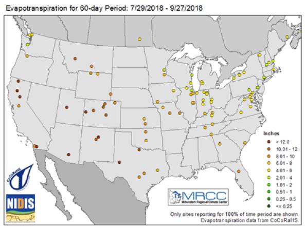
Agricultural crops can wither in a flash when the days turn hot, the air dries, the rain stops and moisture evaporates quickly from the soil. A new early warning system developed by two nationally recognized centers at the University of Nebraska-Lincoln, along with the U.S. Geological Survey, can help alert stakeholders as drought begins.

Published on

The Drought Termination and Amelioration pages from NOAA’s National Centers for Environmental Information offer a customizable interface anyone can use to find information such as (1) the amount of precipitation necessary to end or ameliorate a drought, (2) the percent of normal precipitation needed to end or ameliorate a drought, and (3) the likelihood that that amount of precipitation would fall​.

Published on

In March, June, September, and December, NOAA’s Regional Climate Services Programs create Climate and Drought Outlook documents to inform the public about recent climate impacts within their respective regions. This effort, which began in 2012, now includes as many as 10 unique regional products, all produced collaboratively with partner organizations. Each regional report contains easy-to-understand language and is available to anyone.

Published on

Maps highlighting the effects of drought on six agricultural commodities across the continental U.S. are now available on a website hosted by the National Drought Mitigation Center at the University of Nebraska-Lincoln. The maps are a collaboration between the U.S. Department of Agriculture’s Office of the Chief Economist and the drought center.