U.S. flag

An official website of the United States government

Site Section
News & Events

Soil Moisture 101: What It Means and How It’s Measured

Event Date
February 22, 2022
Event Time
2:00 pm - 3:00 pm
Timezone
EST

The National Integrated Drought Information System (NIDIS) and the National Weather Service (NWS) hosted two webinars on soil moisture data and applications. These webinars were intended to help NWS operational forecasters and other weather & climate service providers better understand soil moisture monitoring and its practical applications.

This first webinar, held on February 22, 2022, provided an overview of soil moisture monitoring and interpretation, including a review of the three main techniques for estimating soil moisture conditions: in situ ground-based systems, satellite measurements, and land surface model outputs.

The second webinar, held on March 29, 2022, featured presentations from climate service professionals on how soil moisture informs their decision making.

This webinar series was sponsored in part by the National Coordinated Soil Moisture Monitoring Network. For more information, please email Marina Skumanich (marina.skumanich@noaa.gov)

Timestamp
0:00

Introduction

Speaker: Marina Skumanich, NOAA's National Integrated Drought Information System


Timestamp
4:59

Overview of Soil Moisture Monitoring

Speaker: Mike Cosh, USDA Agricultural Research Service

Watch This Presentation

  • Volumetric soil moisture: Volume of water per volume of soil
  • How do we measure soil moisture?
    • In situ monitoring
    • Remote sensing from aircraft or satellites
    • Modeling
  • Why do we measure soil moisture? Measuring soil moisture is useful for agricultural management (e.g., effective irrigation), basin management, wildfire risk assessment, etc.


Timestamp
12:01

In Situ Soil Moisture Data and Products

Speaker: Christopher A. Fiebrich, Oklahoma Mesonet

Watch This Presentation

  • Oklahoma Mesonet: 120 sites; average spacing is about 30 km (19 miles)
  • Many different brands of sensors and several different soil moisture parameters (matric potential, volumetric water, fractional water index, plant available water) are used among the various networks.
  • National Mesonet Program: Leverages networks in all 50 states, Puerto Rico, American Samoa, and the U.S. Virgin Islands.
  • Our goals as U.S. Mesonets:
    • Emphasis on data quality, reliability, and completeness
    • Deliver services in near–real time
    • Document climatic conditions over the long term
  • Limitations of in situ soil moisture measurements: In situ measurements are often point observations under sod.
    • What if it rained more on your field than it did at the Mesonet station?
    • What if your field is bare rather than vegetated?
    • What if the soil structure is different at your field than our Mesonet station?


Timestamp
21:38

Satellite-Based Remote Sensing of Soil Moisture

Speaker: John D. Bolten, NASA Goddard Space Flight Center

Watch This Presentation

  • Passive vs. active remote sensing
    • Passive: Emission (radiometer)
      • Less influence from vegetation, soil roughness
      • Sensitive to soil moisture
      • Lower spatial resolution
    • Active: Backscatter (radar)
      • Sensitive to soil moisture, roughness, vegetation
      • Higher spatial resolution
  • Objective of a soil moisture mission is to provide high-resolution and frequent-revisit global maps of soil moisture.
  • The key is to have a longer term consistent data record at higher temporal and spatial resolutions.
  • NASA soil moisture products:


Timestamp
33:39

Model-Output Soil Moisture Data and Products

Speaker: Marina Skumanich, NOAA/NIDIS

Watch This Presentation

  • There is a wide range of land surface models, ranging from simple to complex and with different assumptions/parameterization, geographic coverage, and application targets.
  • Model enhancements/extensions:
  • Modeling: Advantages and Limitations
    • Advantages:
      • Complements in situ data – can't have sensors every km
      • Continuous spatial and temporal resolution
      • Higher resolutions (e.g., 1 km or less)
      • Increasing computing power allows more/better outputs
      • Can do "what ifs" / other types of exploration
    • Limitations:
      • Model is a simplified picture of reality
      • Complexity brings its own issues
      • Quality of forcing data
      • Latency for some modeling systems
  • Blended soil moisture data and products: How can we be more intentional?


Timestamp
41:38

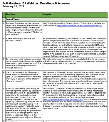
Questions & Answers

Moderator: Maggie Hurwitz, NOAA's National Weather Service

View Questions & Answers (PDF)