Drought Is Likely to Persist Across Portions of the Missouri River Basin with an El Niño Winter Ahead
Key Points
- According to the U.S. Drought Monitor, 35% of the area within Missouri River Basin states are in drought. The most intense conditions are in eastern Nebraska, where Exceptional Drought (D4) has persisted in some areas since late spring 2023.
- Drought impacts are most prominent across Kansas, Nebraska, Missouri, and Iowa. Streamflow and other surface water (including livestock ponds) are very low, municipal water supply has been negatively affected in Iowa and Missouri, and vegetation (including winter wheat and Christmas tree seedlings) lack the moisture needed to grow.
- Strong El Niño conditions have developed in the Pacific Ocean and are expected to continue. While each El Niño event is different, El Niño winters (Dec-Jan-Feb) tend to be warmer across much of the Missouri River Basin and drier in the Northern Rockies.
- The seasonal precipitation outlook for January – March 2024 has increased chances of below-normal precipitation in the northwestern portions of the basin, which, combined with above-normal temperatures, could mean less mountain snowfall. This would have a negative impact as snowfall during the winter in the Northern Plains is critical to replenish moisture in the system for the following year.
- The Seasonal Drought Outlook for the end of December through March 31, 2024 shows that drought is expected to persist across the Missouri River Basin, with the possibility of drought development in the Northern Rockies as well.
The U.S. Drought Monitor depicts the location and intensity of drought across the country. The map uses 5 classifications: Abnormally Dry (D0), showing areas that may be going into or are coming out of drought, and four levels of drought (D1–D4).
The U.S. Drought Monitor is a joint effort of the National Oceanic and Atmospheric Administration, U.S. Department of Agriculture, and National Drought Mitigation Center.
Drought & Dryness Categories
% AreaAbnormally Dry
Abnormally Dry (D0) indicates a region that is going into or coming out of drought. View typical impacts by state.
Moderate Drought
Moderate Drought (D1) is the first of four drought categories (D1–D4), according to the U.S. Drought Monitor. View typical impacts by state.
Severe Drought
Severe Drought (D2) is the second of four drought categories (D1–D4), according to the U.S. Drought Monitor. View typical impacts by state.
Extreme Drought
Extreme Drought (D3) is the third of four drought categories (D1–D4), according to the U.S. Drought Monitor. View typical impacts by state.
Exceptional Drought
Exceptional Drought (D4) is the most intense drought category, according to the U.S. Drought Monitor. View typical impacts by state.
Total Area in Drought (D1–D4)
Percent area of the states in the Missouri River Basin that is currently in drought (D1–D4), according to the U.S. Drought Monitor.
The U.S. Drought Monitor depicts the location and intensity of drought across the country. The map uses 5 classifications: Abnormally Dry (D0), showing areas that may be going into or are coming out of drought, and four levels of drought (D1–D4).
The U.S. Drought Monitor is a joint effort of the National Oceanic and Atmospheric Administration, U.S. Department of Agriculture, and National Drought Mitigation Center.
This map is released every Thursday morning, with data valid through Tuesday at 7 a.m. ET.
Current Conditions for the Missouri River Basin
- According to the U.S. Drought Monitor, 35% of the area within Missouri River Basin states are in drought. The most intense conditions are in eastern Nebraska, where Exceptional Drought (D4) has persisted in some areas since late spring 2023.
- A large portion of the basin remains relatively drought free—primarily across eastern Colorado, western Nebraska, South Dakota, North Dakota, eastern Montana, and Wyoming. Some of these areas have seen drought improve over the fall season (Figure 1).
- Precipitation totals have been mixed across the Missouri River Basin over the last 90 days, with below-normal precipitation across much of Colorado, southern Wyoming, western Kansas, and portions of Nebraska (including eastern Nebraska where the worst drought conditions exist), Iowa, and Missouri (Figure 2).
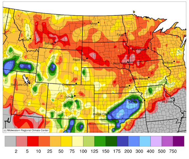
- While early in the season, snowfall has been below normal across the Missouri River Basin so far this winter (Figure 3). According to the USDA Natural Resources Conservation Service (NRCS), snowfall in the Missouri River Basin is only 67% of normal.
Figure 1. 13-Week U.S. Drought Monitor Change Map (Since September 19, 2023)
Key Takeaway: The states within the Missouri River Basin have seen some drought areas improve over the fall season. Areas with drought improvement include northern Montana, northern North Dakota, eastern South Dakota, central Nebraska, and portions of Missouri, northwest Iowa, and Minnesota.
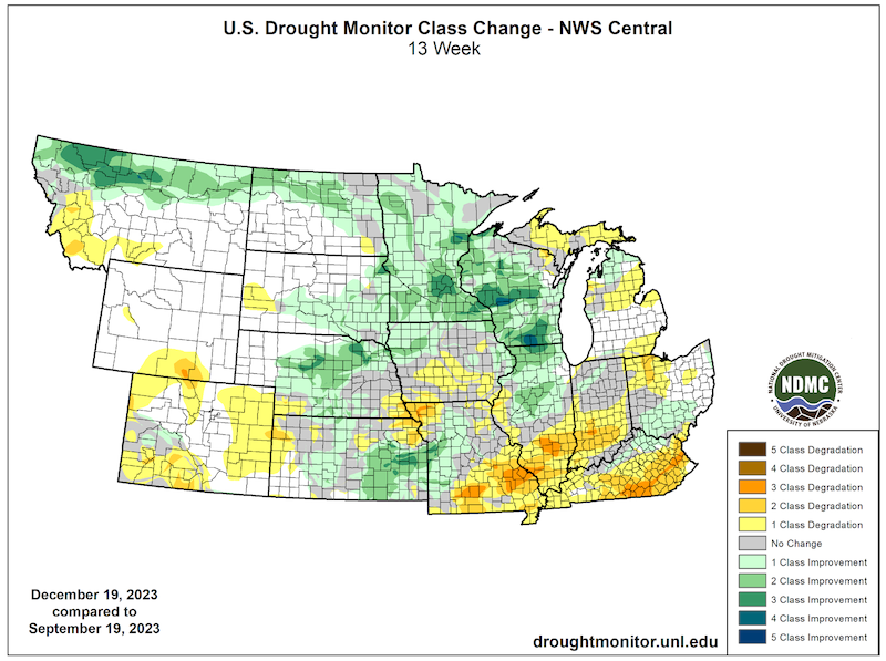
Figure 2. 90-Day Percent of Normal Precipitation (September 21–December 19, 2023)
Key Takeaway: Precipitation totals were mixed across the Missouri River Basin over the last 90 days, since early fall. Below-normal precipitation was widespread across Colorado, as well as portions of Kansas, Nebraska, Wyoming, Iowa, and Missouri.
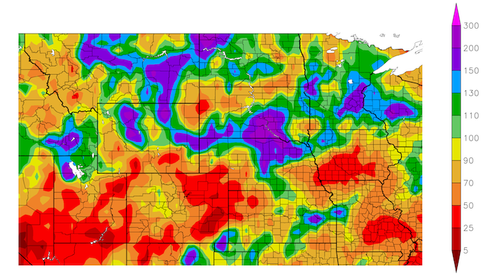
Figure 3. Percent of Normal Snowfall from November 1–December 20, 2023
Key Takeaway: Snowfall has been below normal so far this season across the majority of the Missouri River Basin, particularly across Montana, South Dakota, Iowa, and Minnesota. Portions of Kansas have received above-normal snowfall during an event in late November.
Missouri River Basin Drought Impacts
- Streamflow is below normal across the areas in drought, most notably portions of Kansas, Nebraska, Iowa, and portions of Missouri (Figure 4).Soil moisture is adequate across much of the region, with the exception of portions of Nebraska, Kansas, and Missouri.
- While vegetation impacts from drought are not prominent this time of year, drought has had an impact on some vegetation, including Christmas trees. Christmas tree farms in Nebraska and Missouri report losing seedlings this year due to the dry conditions. Reduced moisture has also been an issue for winter wheat in portions of Kansas and Missouri.
- Municipal water supply has been negatively affected by drought in Iowa and Missouri. In late October, Osceola, Iowa said they have only about 200 days’ worth of water left after enduring three years of drought. After reconfiguring a water intake, the city now has about 330 days' worth of water. Other cities in Iowa have had to explore alternative water sources or enforce water conservation measures.
- Surface water is low across Kansas, eastern Nebraska, and portions of Missouri, including livestock ponds. Pasture conditions are very poor across these areas as well, and supplemental feed and water are required to maintain livestock conditions (Figure 5).
- Low surface water and lack of snowfall and ice are also affecting recreation and tourism for boating and winter-related activities like ice fishing.
Report your local drought impacts through a Condition Monitoring Observer Report:
Figure 4. Current Streamflow Conditions (Valid December 20, 2023)
Key Takeaway: Persistent drought conditions this fall have resulted in below-normal streamflow across portions of Kansas, Nebraska, Iowa, and portions of Missouri.
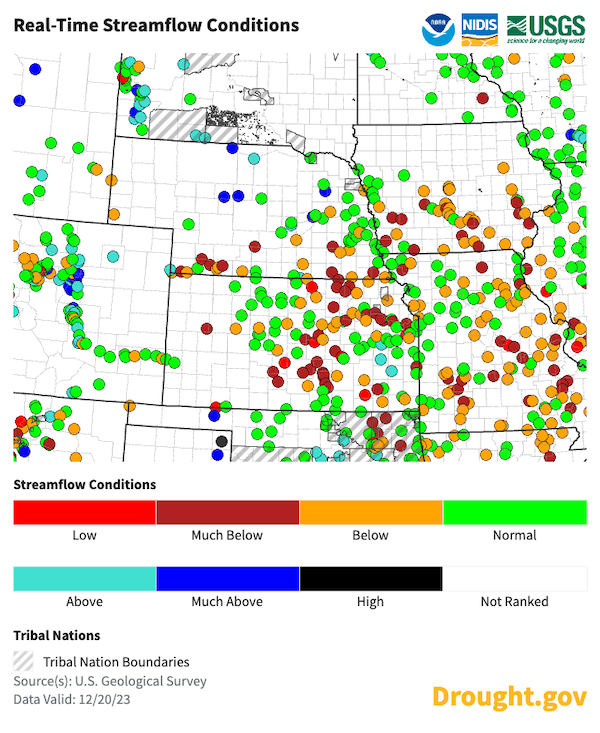
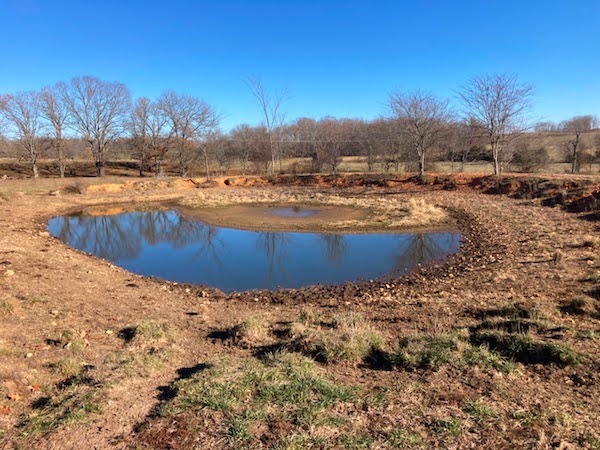
Figure 5. Stock Pond in Miller County, Missouri on December 8, 2023
Key Takeaway: Surface water is very low across portions of Kansas, Nebraska, Iowa, and Missouri, including this stock pond in Miller County, Missouri.
Outlooks and Forecasts for the Missouri River Basin
- January 2024 temperatures are likely to be above normal across the northern Basin, with equal chances for above-, near-, or below-normal precipitation across the entire Missouri River Basin.
- El Niño conditions have developed in the Pacific Ocean and are expected to continue. While each El Niño event is different, El Niño winters (Dec-Jan-Feb) tend to be warmer across much of the Missouri River Basin and drier in the Northern Rockies.
- NOAA’s winter outlook for January through March 2024 shows an increased chance of above-normal temperatures across much of the Basin. Eastern Colorado and western Kansas are likely to have near-normal temperatures, with equal chances for above-, near-, or below-normal temperatures elsewhere (Figure 6).
- The January–March precipitation outlook has increased chances of below-normal precipitation in the northwestern portions of the basin, which, combined with above-normal temperatures, could mean less mountain snowfall. This would have a negative impact as snowfall during the winter in the northern Plains is critical to replenish moisture in the system for the following year.
- Above-normal precipitation is slightly favored in the southern part of the basin, including Colorado, Kansas and Nebraska (Figure 7). Above-normal precipitation would be helpful in these areas; however, drought improvement over the winter months is minimal as soils are often frozen and this limits the ability to replenish soil moisture.
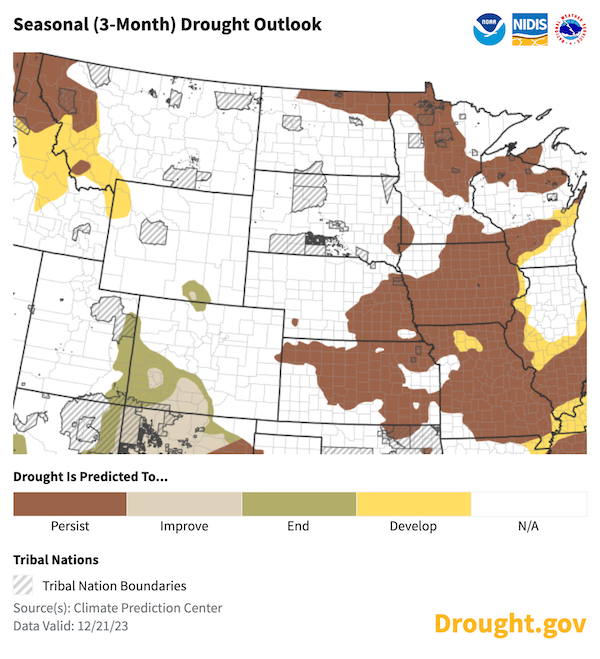
- The Seasonal Drought Outlook for the end of December through March 31, 2024 shows that drought is expected to persist across the region, with the possibility of drought development in the Northern Rockies as well (Figure 8).
Figure 6. Seasonal Temperature Outlook (January–March 2024)
Key Takeaway: Temperatures are likely to be above normal across a majority of the Missouri River Basin, particularly across Montana, North Dakota, South Dakota, and Minnesota for the January through March 2024 time frame. Eastern Colorado and western Kansas are likely to have near-normal temperatures, with equal chances for above-, near-, or below-normal temperatures elsewhere.
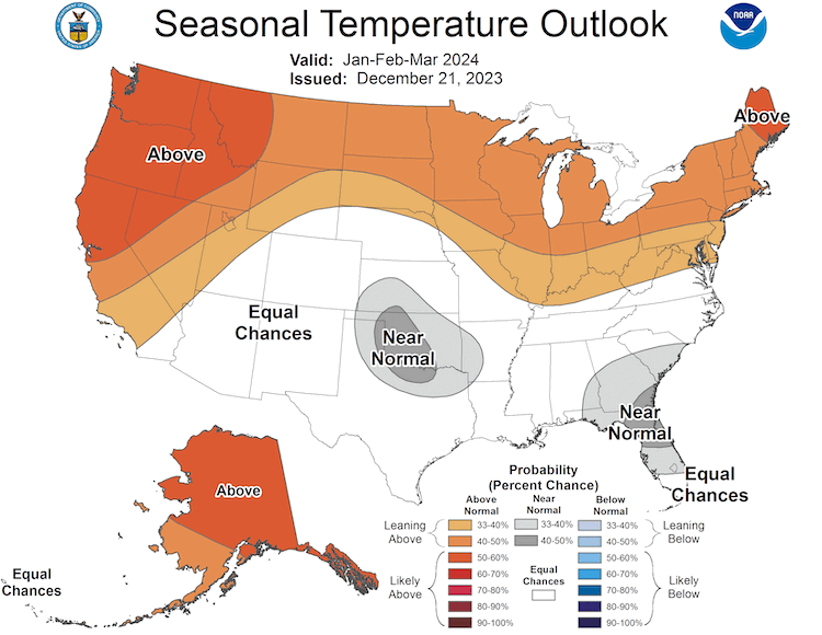
Figure 7. Seasonal Precipitation Outlook (January 2023–March 2024)
Key Takeaway: Below-normal precipitation is anticipated across the northern Missouri River Basin for January through March 2024. There is a slight chance for above-normal precipitation across Colorado, Kansas, and Nebraska.
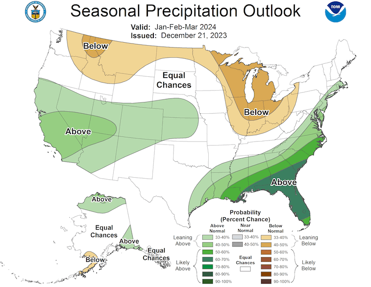
Figure 8. Seasonal Drought Outlook (Valid December 21–March 31, 2024)
Key Takeaway: Drought is expected to persist across areas in drought in the Missouri River Basin, which includes Nebraska, Kansas, Missouri, Iowa, and northern North Dakota. Drought in the Northern Rockies is expected to persist and/or develop as well. There often isn’t much change in drought over the winter as soils are frozen and this limits the ability to replenish soil moisture.
Resources
- Register for the North Central U.S. Climate and Drought Summary & Outlook Webinar on Thursday, December 21 at 1 p.m. Central, which will provide an overview of climate and drought conditions, impacts, and outlooks.
- Read more information about the potential impacts of El Niño in the Missouri River Basin this winter in the November 2023 El Niño Impacts and Outlook report from NOAA and partners.
- More local information is available from the following resources:
- To report or view local drought impact information:
Prepared By
Molly Woloszyn
NOAA/National Integrated Drought Information System (NIDIS), CIRES/CU Boulder
Doug Kluck
NOAA/National Centers for Environmental Information
Dannele Peck & Dennis Todey
USDA Northern Plains Climate Hub and Midwest Climate Hub
Audra Bruschi
NOAA/National Weather Service Central Region
Kevin Low
NOAA/Missouri Basin River Forecast Center
Gannon Rush & Rezaul Mahmood
High Plains Regional Climate Center/University of Nebraska-Lincoln
Denise Gutzmer
National Drought Mitigation Center/University of Nebraska-Lincoln
A special thank you to the state climate offices and National Weather Service offices in the Missouri River Basin for providing local information on drought conditions and impacts included in the webinar and in this Drought Status Update.
This Drought Status Update is issued in partnership between the National Oceanic and Atmospheric Administration (NOAA), U.S. Department of Agriculture (USDA), and the National Drought Mitigation Center to communicate a potential area of concern for drought expansion and/or development within the Missouri River Basin DEWS based on recent conditions and the upcoming forecast. NIDIS and its partners will issue future Drought Status Updates as conditions evolve.


