Drought May Persist, Worsen Through September Amid Warm, Dry Conditions
Key Points
- According to the U.S. Drought Monitor, 32% of the area within Missouri River Basin states are in drought. The most intense conditions are in Montana, Wyoming, and South Dakota, where Extreme Drought (D3) persists.
- Drought conditions deteriorated in many areas of the basin over June–August, especially in the western half of the basin.
- Drought impacts are most prominent across Wyoming, Montana, and the Dakotas where soil moisture is very low, and large wildfires fueled by dry vegetation are impacting the agriculture and tourism industries.
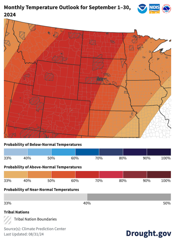
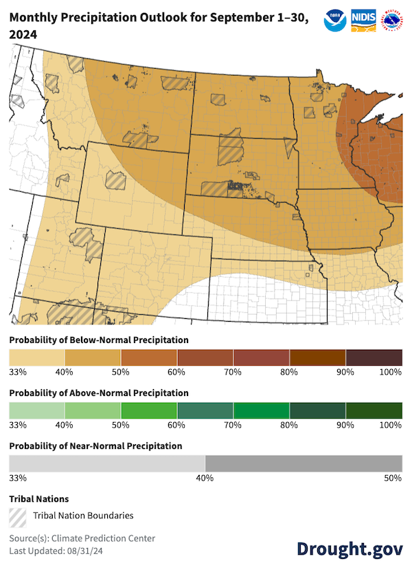
- The Climate Prediction Center’s monthly precipitation and temperature outlooks for September 2024 predict increased chances of below-normal precipitation and above-normal temperatures across the basin. This combination could result in further degradation of soil moisture, range/pasture conditions, and surface water levels. These conditions may impact navigation on the lower Missouri River and therefore agriculture across the High Plains.
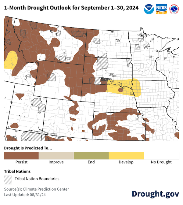
- The Climate Prediction Center’s monthly drought outlook for September predicts existing areas of drought will persist and drought will develop along the eastern half of the border between South Dakota and Nebraska.
The U.S. Drought Monitor depicts the location and intensity of drought across the country. The map uses 5 classifications: Abnormally Dry (D0), showing areas that may be going into or are coming out of drought, and four levels of drought (D1–D4).
The U.S. Drought Monitor is a joint effort of the National Oceanic and Atmospheric Administration, U.S. Department of Agriculture, and National Drought Mitigation Center.
A drought index combines multiple drought indicators (e.g., precipitation, temperature, soil moisture) to depict drought conditions. For some products, like the U.S. Drought Monitor, authors combine their analysis of drought indicators with input from local observers. Other drought indices, like the Standardized Precipitation Index (SPI), use an objective calculation to describe the severity, location, timing, and/or duration of drought.
Learn MorePeriods of drought can lead to inadequate water supply, threatening the health, safety, and welfare of communities. Streamflow, groundwater, reservoir, and snowpack data are key to monitoring and forecasting water supply.
Learn MoreDrought can reduce the water availability and water quality necessary for productive farms, ranches, and grazing lands, resulting in significant negative direct and indirect economic impacts to the agricultural sector. Monitoring agricultural drought typically focuses on examining levels of precipitation, evaporative demand, soil moisture, and surface/groundwater quantity and quality.
Learn MoreDrought & Dryness Categories
% AreaD0 – Abnormally Dry
Abnormally Dry (D0) indicates a region that is going into or coming out of drought. View typical impacts by state.
D1 – Moderate Drought
Moderate Drought (D1) is the first of four drought categories (D1–D4), according to the U.S. Drought Monitor. View typical impacts by state.
D2 – Severe Drought
Severe Drought (D2) is the second of four drought categories (D1–D4), according to the U.S. Drought Monitor. View typical impacts by state.
D3 – Extreme Drought
Extreme Drought (D3) is the third of four drought categories (D1–D4), according to the U.S. Drought Monitor. View typical impacts by state.
D4 – Exceptional Drought
Exceptional Drought (D4) is the most intense drought category, according to the U.S. Drought Monitor. View typical impacts by state.
Total Area in Drought (D1–D4)
Percent area of the states in the Missouri River Basin that is currently in drought (D1–D4), according to the U.S. Drought Monitor.
The U.S. Drought Monitor depicts the location and intensity of drought across the country. The map uses 5 classifications: Abnormally Dry (D0), showing areas that may be going into or are coming out of drought, and four levels of drought (D1–D4).
The U.S. Drought Monitor is a joint effort of the National Oceanic and Atmospheric Administration, U.S. Department of Agriculture, and National Drought Mitigation Center.
The U.S. Drought Monitor is released every Thursday morning, with data valid through the previous Tuesday at 7 a.m. ET.
A drought index combines multiple drought indicators (e.g., precipitation, temperature, soil moisture) to depict drought conditions. For some products, like the U.S. Drought Monitor, authors combine their analysis of drought indicators with input from local observers. Other drought indices, like the Standardized Precipitation Index (SPI), use an objective calculation to describe the severity, location, timing, and/or duration of drought.
Learn MorePeriods of drought can lead to inadequate water supply, threatening the health, safety, and welfare of communities. Streamflow, groundwater, reservoir, and snowpack data are key to monitoring and forecasting water supply.
Learn MoreDrought can reduce the water availability and water quality necessary for productive farms, ranches, and grazing lands, resulting in significant negative direct and indirect economic impacts to the agricultural sector. Monitoring agricultural drought typically focuses on examining levels of precipitation, evaporative demand, soil moisture, and surface/groundwater quantity and quality.
Learn MoreCurrent Conditions for the Missouri River Basin
- According to the U.S. Drought Monitor, 32% of the states within the Missouri River Basin are in drought. Severe Drought (D2) persists in Kansas, Wyoming, Nebraska, South Dakota, North Dakota, and Montana, with Extreme Drought (D3) impacting portions of Montana, eastern Wyoming, and western South Dakota.
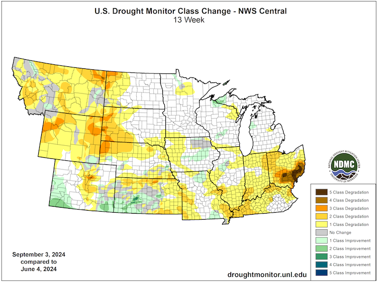
- Conditions deteriorated in many areas of the basin over the summer season (Figure 1). The most severe drought conditions are found in the western half of the basin.
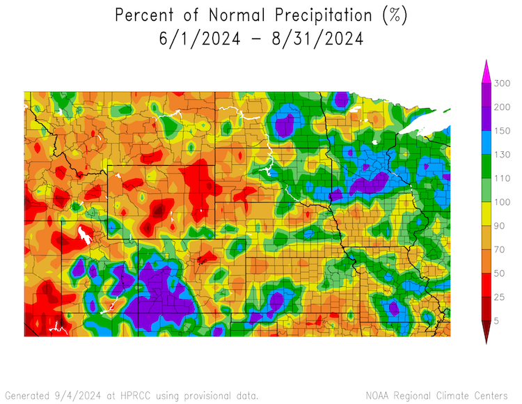
- Below-normal summer precipitation was one driver of this deterioration in many areas (Figure 2). Large parts of Montana, Wyoming, Nebraska, eastern Colorado, and the western portion of South and North Dakota received 5–70% of normal precipitation over June–August. Some of the largest deficits were in Wyoming, Montana, and western South Dakota, where drought conditions worsened. The exception is portions of Kansas and eastern parts of North and South Dakota, which received 100–200% of normal precipitation.
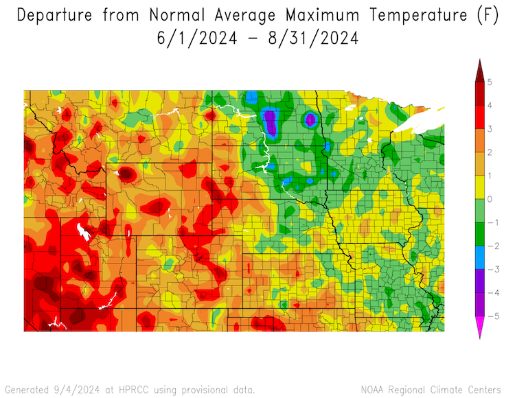
- Somewhat warmer-than-normal maximum air temperatures over the long term (June - August) and short term (7 days) further drove deteriorating conditions across the western part of the basin (Figure 3). These high temperatures dried vegetation and decreased soil moisture, increasing the likelihood of additional drought development.
- August runoff in the Missouri River Basin was 1.2 MAF (million acre-feet), 86% of average above Sioux City. Gavins Point winter releases will be at minimum rate.
Western Parts of the Missouri River Basin Saw Large Drought Degradations Since June 4
Key Takeaway: The western half of the Missouri River Basin states saw drought degradation of 1-3 categories throughout the summer. Areas with drought improvement were very limited.
Summer Precipitation Totals Were Mixed Across the Missouri River Basin
Key Takeaway: Precipitation totals were mixed across the Missouri River Basin over the summer. Large areas of the Basin received below-average to significantly below-average precipitation (below the 50th percentile), especially parts of Montana, Wyoming, western Nebraska, and western South Dakota. Some areas of the Dakotas saw precipitation totals greater than 130% of average due to some very heavy isolated rain events.
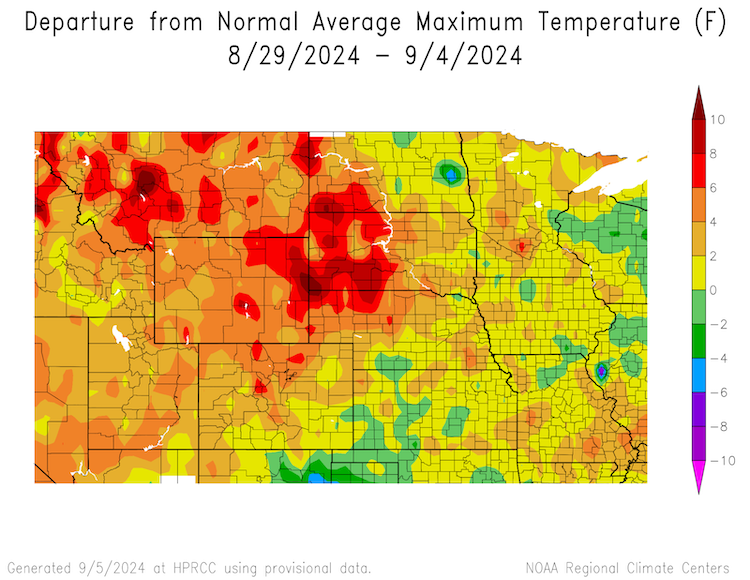
Western Basin Sees Warmer-Than-Normal Temperatures for Summer and the Last Week
Key Takeaway: Late August was cool compared to the long-term average across North Dakota, South Dakota, and parts of Nebraska. Above-average temperatures occurred across the rest of the Missouri River Basin throughout summer. Exceptionally high temperatures occurred in Nebraska, South Dakota, Wyoming, Montana, and North Dakota as a high pressure system settled over parts of the High Plains in late August.
Missouri River Basin Drought Impacts
- Below-normal precipitation and above-normal temperatures across the western part of the region this summer caused negative impacts on the agriculture industry. Pasture and range conditions deteriorated in areas with continued or worsening drought. These poor conditions are coupled with reduced soil moisture across most of the basin (Figures 4, 5, 6). Impacts included heat-stressed crops, grasses curing early, reduced or no second cutting of hay, removal of livestock from pastures early, weaning calves and selling livestock earlier than usual, reducing herd size, buying and feeding hay, and reduced surface water quantity and quality for livestock.
- Nebraska experienced record-breaking temperatures during July 23–August 5, 2024.
- Dry conditions in northeast Wyoming and southeast Montana fueled numerous wildfires, which consumed nearly 500,000 acres of rangelands and reduced air quality. The largest of these fires includes the Remington Fire (at over 196,000 acres as of September 2, 2024) and the House Draw Fire (at nearly 175,000 acres as of September 2, 2024).
- The river runoff forecast for the Missouri River Basin is still below normal due to drought conditions in the western half of the Basin, and reservoir systems continue to release water to meet downstream navigational targets.
- Poor precipitation timing and spotty or limited precipitation totals throughout the summer reduced crop yields for some producers in western North Dakota.
- Portions of Montana saw fishing restrictions or closures to protect fish species amid high water temperatures.
- According to the U.S. Army Corps of Engineers, the six mainstem Missouri River power plants generated 631 million kilowatt-hours (kWh) of electricity in July. Typical energy generation for July is 954 million kWh. These power plants are expected to generate 8.0 billion kWh this year, compared to the long-term average of 9.4 billion kWh.
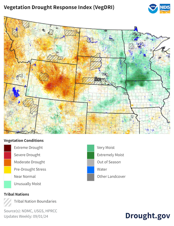
Vegetation Is Drying Across the Western Basin
Key Takeaway: Large precipitation deficits and above-normal maximum temperatures led to significant vegetation drying across Montana, Wyoming, western parts of North Dakota and South Dakota, and Nebraska. Despite above-normal temperatures, recent rains in eastern South Dakota and Nebraska improved vegetation conditions.
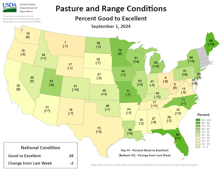
Pasture and Range Conditions Deteriorated, Especially in Montana and Wyoming
Key Takeaway: Pasture and range conditions in Montana and Wyoming were affected by drought, with less than 20% reported as good to excellent. South Dakota and Nebraska report less than 40% of pasture and range in good to excellent condition. Pastures in North Dakota are faring better with 58% in good to excellent condition. Conditions in South Dakota and Nebraska deteriorated over the previous week due to above-average temperatures in late August.
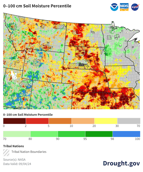
Soil Moisture Conditions Worsened Across the Basin
Key Takeaway: Below-normal precipitation and above-normal maximum temperatures have worsened soil moisture conditions across much of the Basin. The recent heat wave in Nebraska and Kansas has rapidly reduced soil moisture.
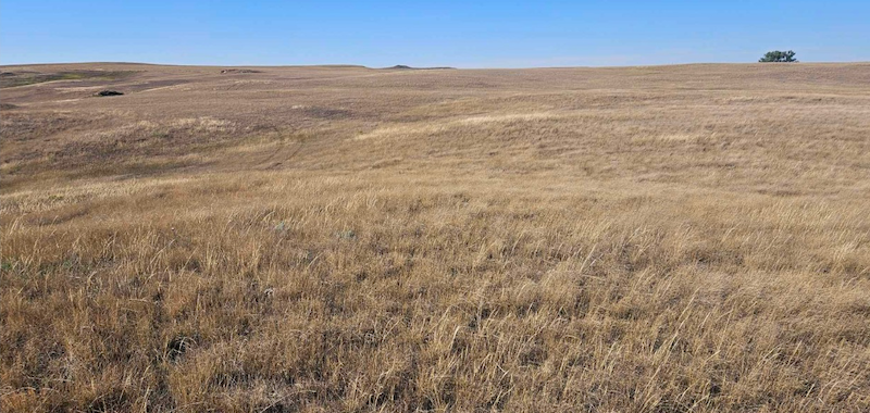
Poor Pasture Conditions in North Dakota
Key Takeaway: Above-normal temperatures and dry conditions have resulted in vegetation curing early and poor pasture conditions.
Outlooks and Potential Impacts for the Missouri River Basin
- The NOAA Climate Prediction Center’s outlook for September 2024 shows an increased chance of above-normal temperatures across the basin. The warm temperatures are coupled with an increased probability of below-normal precipitation across the basin (Figure 8), further increasing the chance of drought degradation.
- Through the end of September, the Climate Prediction Center’s Monthly Drought Outlook predicts that drought will likely persist in areas already in drought, with drought degradation likely in South Dakota and Nebraska. Drought improvement is not expected in the basin (Figure 9).
- The next three months (September–November) have increased chances of transitioning from El Niño–Southern Oscillation (ENSO) neutral to La Niña conditions. La Niña can cause cooler winter temperatures in the northern High Plains.
- Combined with above-normal temperatures, below-normal precipitation could mean lower streamflows, reduced soil moisture, crop stress, and additional livestock impacts. The combination of hot and dry weather could hamper establishment of fall-planted crops such as winter wheat and cover crops, but could also help with drydown of fall-harvested grain corn.
Increased Chances for Hotter and Drier Weather in September 2024
Key Takeaway: According to the National Weather Service Climate Prediction Center, there are increased chances of above-normal temperatures across all of the Missouri River Basin states during September 2024. Most of the region is predicted to see below-normal precipitation during September 2024.
Drought Predicted to Continue or Develop in September
Key Takeaway: The Climate Prediction Center predicts drought conditions will likely persist across parts of Montana, Wyoming, North Dakota, South Dakota, and Nebraska, and will likely develop across parts of northern Nebraska, southern South Dakota, and western Iowa through the end of September. No drought improvement is forecasted for the basin.
Additional Resources
- Register for the North Central U.S. Climate and Drought Summary & Outlook Webinar on Thursday, September 19 at 1 p.m. CT/12 p.m. MT, which will provide an overview of climate and drought conditions, impacts, and outlooks.
- Register for the Wyoming Conditions & Outlooks Webinar on Thursday, September 19 at 2 p.m. CT/1 p.m. MT by emailing Windy Kelley, USDA Northern Plains Climate Hub coordinator.
- More local information is available from the following resources:
- To report or view local drought impact information:
Prepared By
Jason Gerlich
Cooperative Institute for Research in Environmental Sciences (CIRES), CU Boulder
NOAA/National Integrated Drought Information System (NIDIS)
Doug Kluck
NOAA/National Centers for Environmental Information
Dannele Peck, Windy Kelley, and Dennis Todey
USDA Northern Plains and Midwest Climate Hubs
Audra Bruschi
NOAA/National Weather Service Central Region
Kevin Low
NOAA/Missouri Basin River Forecast Center
Rezaul Mahmood and Gannon Rush
High Plains Regional Climate Center/University of Nebraska
Laura Edwards
South Dakota State University State Climatologist
Zachary Hoylman
University of Montana Assistant State Climatologist
Daryl Ritchison
North Dakota University State Climatologist
This Drought Status Update is issued in partnership between the National Oceanic and Atmospheric Administration (NOAA), U.S. Department of Agriculture (USDA), and the National Drought Mitigation Center to communicate a potential area of concern for drought expansion and/or development within the Missouri River Basin DEWS based on recent conditions and the upcoming forecast. NIDIS and its partners will issue future Drought Status Updates as conditions evolve.


