Warm and Dry Conditions Drive Persistent Drought Across the Region
Key Points
- According to the U.S. Drought Monitor, 69% of the area within Missouri River Basin states is in drought. The most intense conditions are in Montana, Wyoming, Colorado, North Dakota, South Dakota, and Nebraska, where Extreme Drought (D3) persists.
- Drought conditions deteriorated in many areas of the basin through the first three months of the water year (October–December 2024).
- The 2025 Water Year (October 1, 2024–September 30, 2025) is off to a slow start across the region, with above-normal temperatures and below-normal precipitation further deteriorating drought conditions. The lack of precipitation could be troublesome for winter wheat and spring planting conditions.
- Snow drought conditions are currently found in portions of western Montana and northern Wyoming due to warm and dry conditions through most of December, with the Upper Missouri basins showing the lowest snowpack in the region.
- The Climate Prediction Center's (CPC's) monthly precipitation and temperature outlooks for January 2025 favor increased chances of above-normal precipitation and below-normal temperatures across parts of the basin.
- Despite favorable precipitation forecasts, CPC’s monthly drought outlook for January predicts existing areas of drought will persist. Removal of drought deficits is difficult in winter, because precipitation is generally low and the ground is frozen, preventing soil and groundwater recharge.
The U.S. Drought Monitor depicts the location and intensity of drought across the country. The map uses 5 classifications: Abnormally Dry (D0), showing areas that may be going into or are coming out of drought, and four levels of drought (D1–D4).
The U.S. Drought Monitor is a joint effort of the National Oceanic and Atmospheric Administration, U.S. Department of Agriculture, and National Drought Mitigation Center.
A drought index combines multiple drought indicators (e.g., precipitation, temperature, soil moisture) to depict drought conditions. For some products, like the U.S. Drought Monitor, authors combine their analysis of drought indicators with input from local observers. Other drought indices, like the Standardized Precipitation Index (SPI), use an objective calculation to describe the severity, location, timing, and/or duration of drought.
Learn MorePeriods of drought can lead to inadequate water supply, threatening the health, safety, and welfare of communities. Streamflow, groundwater, reservoir, and snowpack data are key to monitoring and forecasting water supply.
Learn MoreDrought can reduce the water availability and water quality necessary for productive farms, ranches, and grazing lands, resulting in significant negative direct and indirect economic impacts to the agricultural sector. Monitoring agricultural drought typically focuses on examining levels of precipitation, evaporative demand, soil moisture, and surface/groundwater quantity and quality.
Learn MoreDrought & Dryness Categories
% AreaD0 – Abnormally Dry
Abnormally Dry (D0) indicates a region that is going into or coming out of drought. View typical impacts by state.
D1 – Moderate Drought
Moderate Drought (D1) is the first of four drought categories (D1–D4), according to the U.S. Drought Monitor. View typical impacts by state.
D2 – Severe Drought
Severe Drought (D2) is the second of four drought categories (D1–D4), according to the U.S. Drought Monitor. View typical impacts by state.
D3 – Extreme Drought
Extreme Drought (D3) is the third of four drought categories (D1–D4), according to the U.S. Drought Monitor. View typical impacts by state.
D4 – Exceptional Drought
Exceptional Drought (D4) is the most intense drought category, according to the U.S. Drought Monitor. View typical impacts by state.
Total Area in Drought (D1–D4)
Percent area of the states in the Missouri River Basin that is currently in drought (D1–D4), according to the U.S. Drought Monitor.
The U.S. Drought Monitor depicts the location and intensity of drought across the country. The map uses 5 classifications: Abnormally Dry (D0), showing areas that may be going into or are coming out of drought, and four levels of drought (D1–D4).
The U.S. Drought Monitor is a joint effort of the National Oceanic and Atmospheric Administration, U.S. Department of Agriculture, and National Drought Mitigation Center.
The U.S. Drought Monitor is released every Thursday morning, with data valid through the previous Tuesday at 7 a.m. ET.
A drought index combines multiple drought indicators (e.g., precipitation, temperature, soil moisture) to depict drought conditions. For some products, like the U.S. Drought Monitor, authors combine their analysis of drought indicators with input from local observers. Other drought indices, like the Standardized Precipitation Index (SPI), use an objective calculation to describe the severity, location, timing, and/or duration of drought.
Learn MorePeriods of drought can lead to inadequate water supply, threatening the health, safety, and welfare of communities. Streamflow, groundwater, reservoir, and snowpack data are key to monitoring and forecasting water supply.
Learn MoreDrought can reduce the water availability and water quality necessary for productive farms, ranches, and grazing lands, resulting in significant negative direct and indirect economic impacts to the agricultural sector. Monitoring agricultural drought typically focuses on examining levels of precipitation, evaporative demand, soil moisture, and surface/groundwater quantity and quality.
Learn MoreCurrent Conditions for the Missouri River Basin
This update is based on data available as of Tuesday, January 7, 2025 at 12:00 a.m. CT. We acknowledge that conditions are evolving.
- According to the U.S. Drought Monitor, 69% of the area within the Missouri River Basin is in drought. Severe Drought (D2) persists in all the basin states, with Extreme Drought (D3) impacting portions of Montana, Wyoming, Colorado, North Dakota, South Dakota, and Nebraska.
- Drought conditions have further deteriorated or persisted across most of the region since the start of the water year (October 1, 2024). During this time, parts of Montana, Wyoming, North Dakota, South Dakota, and Nebraska saw 2–3 class degradations in drought conditions on the U.S. Drought Monitor. Isolated improvements occurred across the region, with the greatest improvements in Kansas and Colorado following a significant November snow storm.
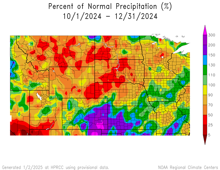
- Below-normal fall and winter precipitation was one driver of this deterioration in many areas across the region. Substantial precipitation deficits occurred across large parts of Montana, Wyoming, North Dakota, South Dakota, and Nebraska. These areas received less than 50% of normal precipitation over October–December. The exception is portions of Kansas and Colorado, which received 100%–200% of normal precipitation.
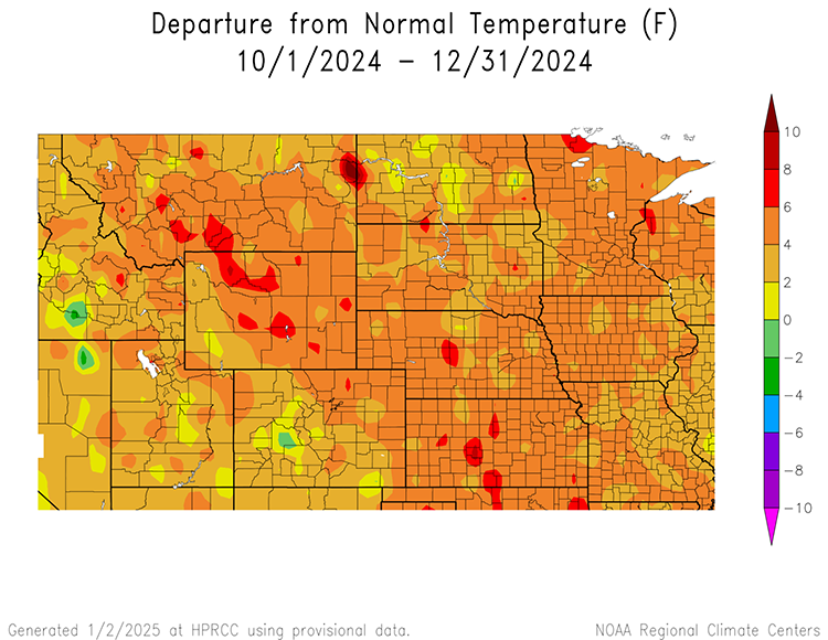
- Warmer-than-normal temperatures through the first three months of the water year (October–December) also drove deteriorating conditions across the region. These above-normal temperatures can drive evapotranspiration and rapidly melt snow, which further decreases soil moisture and increases the likelihood of additional drought development and poor spring planting conditions.
Since the Start of Water Year, Drought Conditions Continue to Deteriorate
Key Takeaway: All of the Missouri River Basin states saw drought persistence or degradation of 1–3 categories throughout the fall and early winter. Areas with drought improvement were limited.
Water Year 2025 Precipitation Totals Slip Below Normal
Key Takeaway: Precipitation totals across the Missouri River Basin through the fall and early winter were below normal. Large areas of the basin received below-average to significantly below-average (below the 50th percentile) precipitation, especially across Montana, Wyoming, North Dakota, South Dakota, and Nebraska. Colorado and Kansas saw precipitation totals greater than 100% of average due to a significant November snow storm.
Warm Temperatures Help Drive Deteriorating Drought Conditions
Key Takeaway: Above-average temperatures occurred across all of the Missouri River Basin throughout fall and early winter. Isolated parts of the region experienced temperatures 6-10 degrees Fahrenheit above normal.
Outlooks and Potential Impacts for the Missouri River Basin
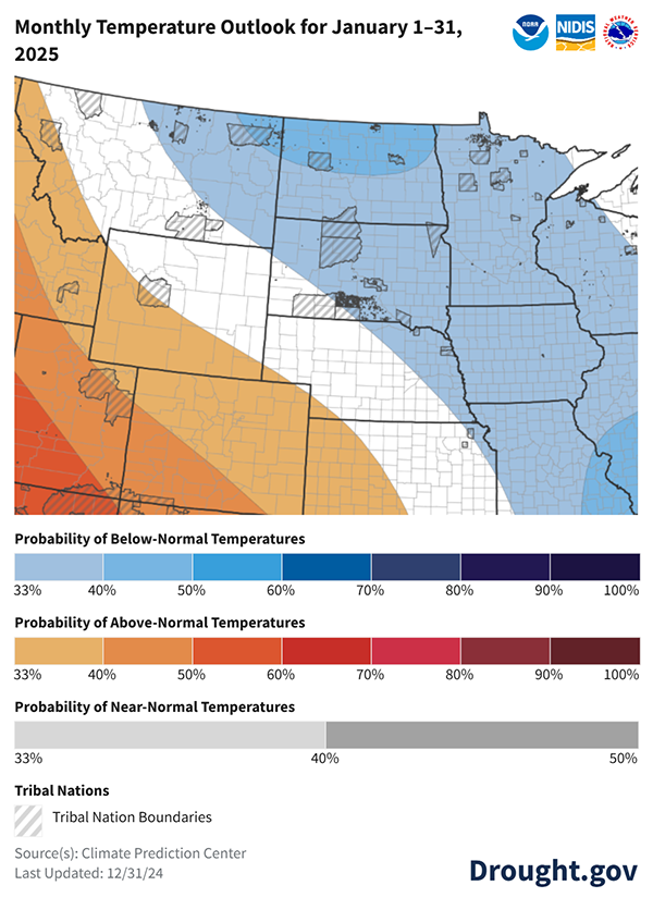
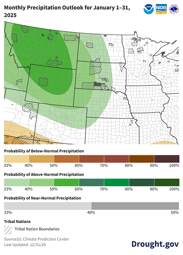
- The NOAA Climate Prediction Center’s outlook for January 2025 shows an increased chance of below-normal temperatures across the basin. The below-normal temperatures are coupled with an increased probability of above-normal precipitation across most of the region.
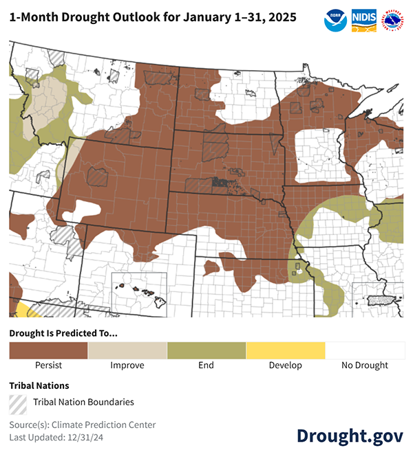
- Through the end of January, the Climate Prediction Center’s Monthly Drought Outlook favors drought persistence in areas already in drought. Drought improvement is only expected in western Montana and isolated areas of Nebraska and Kansas. The Seasonal Drought Outlook through March 31, 2025 also calls for drought to persist across the region.
- The combination of hot and dry weather and limited relief predicted could hamper establishment of spring-planted crops and stunt forage green-up. However, the Missouri River Basin usually receives less precipitation in autumn and winter than it does in the spring and summer months.
Possible Pattern Shift Towards Cooler and Wetter Weather in January 2025
Key Takeaway: According to the Climate Prediction Center, there are increased chances of below-normal temperatures across the eastern Missouri River Basin states during January 2025. Parts of Wyoming, Colorado, Nebraska, and Kansas could see increased chances of above-normal temperatures. Most of the region is predicted to see above-normal precipitation—or has equal chances of above-, below-, or near-normal precipitation—during January 2025.
Drought Predicted to Persist in January
Key Takeaway: The Climate Prediction Center favors persistent drought conditions across the region in January. Improvements are more likely to occur in western Montana and isolated areas of southeast Nebraska and northeast Kansas.
Additional Resources
- Register for the North Central U.S. Climate and Drought Summary & Outlook Webinar on Thursday, January 16 at 1 p.m. CT/12 p.m. MT, which will provide an overview of climate and drought conditions, impacts, and outlooks.
- Register for the Wyoming Conditions & Outlooks Webinar on Thursday, January 16 at 2 p.m. CT/1 p.m. MT by emailing Windy Kelley, Northern Plains Climate Hub coordinator.
- More local information is available from the following resources:
- To report or view local drought impact information:
Prepared By
Jason Gerlich
Cooperative Institute for Research in Environmental Sciences (CIRES), CU Boulder
NOAA/National Integrated Drought Information System (NIDIS)
Doug Kluck
NOAA/National Centers for Environmental Information
Dannele Peck & Windy Kelley
U.S. Department of Agriculture Northern Plains Climate Hub
Rezaul Mahmood & Gannon Rush
High Plains Regional Climate Center/University of Nebraska
Laura Edwards
South Dakota State University State Climatologist
Antony R. Bergantino
Wyoming State Climate Office/University of Wyoming
Jeff Boyne, Shawn Rossi & Megan Jones
National Weather Service Central Region Weather Forecast Offices
Andrea Thielke
National Weather Service Central Region Headquarters
Denise Gutzmer
National Drought Mitigation Center
This Drought Status Update is issued in partnership between the National Oceanic and Atmospheric Administration (NOAA), U.S. Department of Agriculture (USDA), and the National Drought Mitigation Center to communicate a potential area of concern for drought expansion and/or development within the Missouri River Basin DEWS based on recent conditions and the upcoming forecast. NIDIS and its partners will issue future Drought Status Updates as conditions evolve.


