A Very Wet Week has Improved, But Not Eliminated, Drought in the Southern Plains
Key Points
- Over 5 inches of rain soaked eastern Texas, northern Louisiana, and southwestern Arkansas.
- Exceptional Drought (D4) persists in southeastern New Mexico, but has been removed from the rest of the Southern Plains region
- Drought expanded into the South Texas Plains, and along the Rio Grande
This animation provides a look back at drought changes over the last 3 months, from October 24, 2023 to January 23, 2024.
The U.S. Drought Monitor depicts the location and intensity of drought across the country. The map uses 5 classifications: Abnormally Dry (D0), showing areas that may be going into or are coming out of drought, and four levels of drought (D1–D4).
The U.S. Drought Monitor is a joint effort of the National Oceanic and Atmospheric Administration, U.S. Department of Agriculture, and National Drought Mitigation Center.
U.S. Drought Monitor
D0 - Abnormally Dry
Abnormally Dry (D0) indicates a region that is going into or coming out of drought, according to the U.S. Drought Monitor. View typical impacts by state.
D1 – Moderate Drought
Moderate Drought (D1) is the first of four drought categories (D1–D4), according to the U.S. Drought Monitor. View typical impacts by state.
D2 – Severe Drought
Severe Drought (D2) is the second of four drought categories (D1–D4), according to the U.S. Drought Monitor. View typical impacts by state.
D3 – Extreme Drought
Extreme Drought (D3) is the third of four drought categories (D1–D4), according to the U.S. Drought Monitor. View typical impacts by state.
D4 – Exceptional Drought
Exceptional Drought (D4) is the most intense drought category, according to the U.S. Drought Monitor. View typical impacts by state.
This animation provides a look back at drought changes over the last 3 months, from October 24, 2023 to January 23, 2024.
The U.S. Drought Monitor depicts the location and intensity of drought across the country. The map uses 5 classifications: Abnormally Dry (D0), showing areas that may be going into or are coming out of drought, and four levels of drought (D1–D4).
The U.S. Drought Monitor is a joint effort of the National Oceanic and Atmospheric Administration, U.S. Department of Agriculture, and National Drought Mitigation Center.
This map is released every Thursday morning, with data valid through Tuesday at 7am Eastern.
Current Drought Conditions in the Southern Plains
- From January 22–25, over 5 inches of rainfall fell in parts of the drought-affected areas of eastern Texas, southwestern Arkansas, and northern Louisiana. This has improved, but not eliminated, drought conditions for these states.
- The current U.S. Drought Monitor shows conditions as of the morning of January 23. The effects of heavy rains in eastern Texas since that time will be reflected in next week’s U.S. Drought Monitor.
- January has been exceptionally cold across most of the Southern Plains.
- Extreme Drought (D3) conditions have been in place in the Southern Plains region since August 2019.
- Moderate (D1) or worse drought has been in the region since June 28, 2016. This is a new drought duration record for the Southern Plains, with drought lasting 396 weeks.
- Extreme Drought (D3) continues over central Texas (including the Hill Country near Austin, San Marcos, and San Antonio), with downstream hydrological impacts. The area most affected by drought expanded southward into Webb and Dimmit Counties.
- In Oklahoma, drought showed gradual improvement over the past month. Severe Drought (D2) persists in Osage, Pontotoc, Open Coal, Atoka, and Pushmataha counties.
- Kansas has experienced a one-category improvement in drought over the last month, with parts of southwest Kansas now drought-free. The last remaining area of Extreme Drought (D3) is in Rooks and Graham counties.
- Southeast New Mexico continues in an Exceptional Drought (D4). Chaves County and Eddy County have been in D4 drought since September.
- Louisiana, while not in the Southern Plains DEWS region, has seen a 1- to 3-category drought improvement over the last month for the Florida Parishes. Exceptional Drought (D4) continues over parts of central and northern Louisiana.
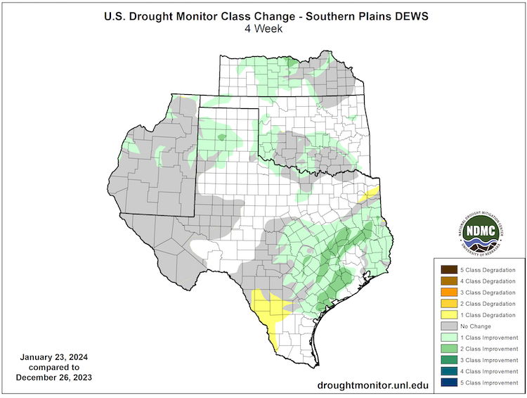
U.S. Drought Monitor 4-Week Change Map
Key Takeaway: Much of the Southern Plains experienced minor improvements from late December to late January. Drought in central Texas expanded southward. Drought persists, unchanged, over the Chihuahuan desert region of western Texas and southern New Mexico.
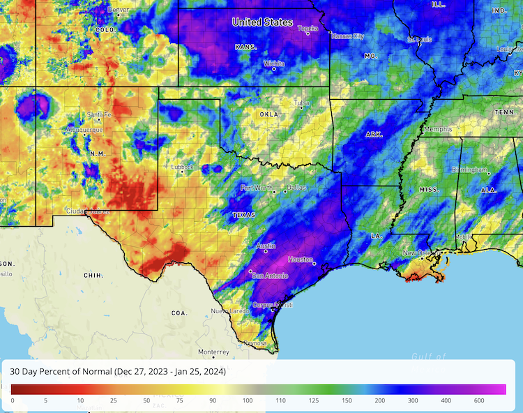
30-Day Percent of Normal Precipitation for the Southern Plains
Key Takeaway: January is usually the driest month of the year for Kansas, Oklahoma, and most of western Texas, including the Panhandle region. These states typically receive less than 5% of their annual precipitation in January. Therefore, even small precipitation events can show up as large anomalies without having a big impact on water availability. Central Texas, Oklahoma, and eastern Kansas had some winter snow and ice storms in mid-January, which provided above- normal precipitation for this time of year. Southern New Mexico and western Texas missed out on needed precipitation over the last month. Severe to Exceptional Drought (D2–D4) continues in these areas.
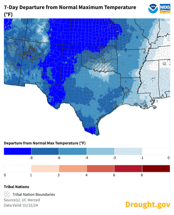
7-Day Departure from Normal Maximum Temperature
Key Takeaway: January has been exceptionally cold across most of the Southern Plains. Mean temperature anomalies for the first 20 days of January ranged from 3 ºF below normal along the Gulf Coast to between 8 ºF and 12 ºF below normal across parts of Kansas.
Temperatures and drought: Frozen soils prevent melting snow from replenishing the soil moisture. Deep freezes, as was experienced across the High Plains in January, tend to pause changes in drought conditions until the soil can thaw and snow can melt.
Southern Plains Drought Impacts
- The expansion of drought conditions in southern Texas, along the Rio Grande, has led to water conservation efforts in Corpus Christi.
- Heavy snow across the Midwest, which fell in mid-January, will help ease drought conditions in Kansas when the snow melts.
- Ongoing drought has impacted Louisiana crawfish supply.
Report your local drought impacts through a Condition Monitoring Observer Report:
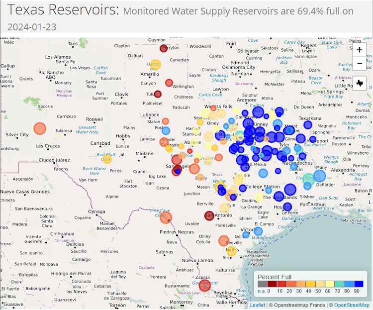
Texas Reservoir Levels
Key Takeaway: Reservoir levels in eastern Texas improved over the past two months, while reservoir levels in central Texas remained low. Lake Travis, for example, which provides water for Austin, continued a steady decline from 45% full last January to its current capacity of 37.7%. Generally across the state, reservoirs in the eastern part of Texas are mainly 70% or more full, while most reservoirs in western Texas are less than half full.
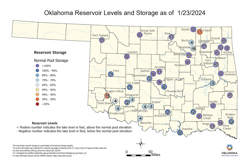
Oklahoma Reservoir Levels
Key Takeaway: Most reservoirs in the northeastern part of Oklahoma are generally more than 90% or more full, while most reservoirs in the southwestern part of the state are less than 80% full.
Outlooks & Potential Impacts for the Southern Plains
- The winter months are usually the driest time of the year for Southern Plains states, with January typically being the driest month of the year for Kansas and Oklahoma.
- El Niño (the current state of the central Pacific Ocean) usually, but not always, means a wetter- than- normal winter for the Southern Plains, with the strongest influence over the Gulf Coast and far southern Texas.
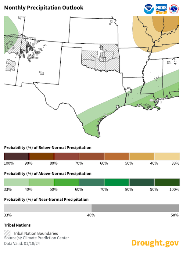
1-Month Precipitation Outlook for February 2024
Key Takeaway: February precipitation shows an equal chance of above-, near-, or below-normal totals across much of the Southern Plains, according to Climate Prediction Center’s outlook. The exception is in far southern Texas and along the Gulf Coast, where odds slightly favor above-normal precipitation.
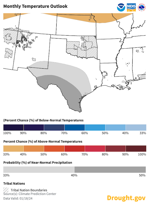
1-Month Temperature Outlook for February 2024
Key Takeaway: The February temperature outlook shows an equal chance of above-, near-, or below-normal temperatures across most of the Southern Plains, according to Climate Prediction Center’s outlook. The exception is far southern Texas, where odds favor near-normal temperatures for the month.
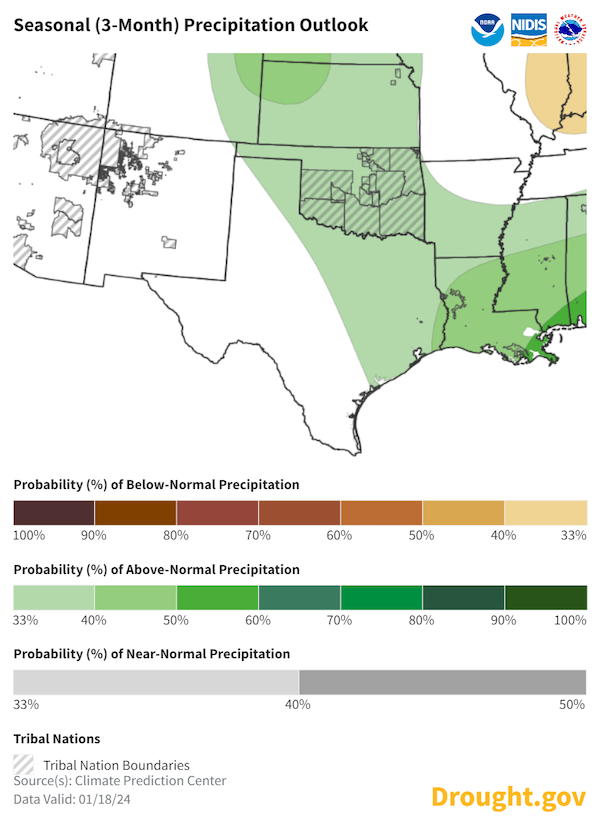
Seasonal (3-Month) Precipitation Outlook for February–April 2024
Key Takeaway: Odds favor above-normal precipitation for Kansas, Oklahoma, and eastern Texas. The rest of the region shows an equal chance of above-, near-, or below-normal precipitation.
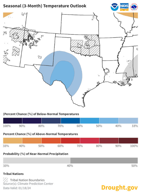
Seasonal (3-Month) Temperature Outlook for February–April 2024
Key Takeaway: A cooler than normal season is likely for Texas’ Big Bend Country and Hill Country. Outside of this, there is an equal chance of above-, near-, or below-normal temperatures for the season (February–April 2024).
Additional Resources
Regional Resources
- Southern Regional Climate Center
- Water Data for Texas
- Oklahoma Mesonet
- More local information is available from the following resources:
Upcoming Events
- February 21, 2024: Woodward, Oklahoma. Weather and Climate Tools Training for Producers.
- March 18–19, 2024: Liberal, Kansas. Ogallala Aquifer Summit.
In Case You Missed It
- November 29, 2023: NOAA/NIDIS released a New Report on Drought Assessment in a Changing Climate.
Prepared By
Joel Lisonbee, Adam Lang, Kelsey Satalino, and Eleanor Hasenbeck
NOAA’s National Integrated Drought Information System, CIRES/CU Boulder
Gary McManus
Oklahoma State Climatologist, Oklahoma Mesonet, Oklahoma Climatological Survey
Matt Sittel
Kansas Assistant State Climatologist, Kansas State University
John Nielsen-Gammon
Texas State Climatologist, Texas State Climate Office, Texas A&M University
Southern Regional Climate Center
William (BJ) Baule and Alison Tarter
Texas State Climate Office, Texas A&M University
Southern Regional Climate Center
Keith White and Victor Murphy
National Weather Service
This drought status update is issued in partnership between the National Oceanic and Atmospheric Administration (NOAA) and the offices of the state climatologist for Texas, Oklahoma, New Mexico, and Kansas. The purpose of the update is to communicate a potential area of concern for drought expansion and/or development within the Southern Plains based on recent conditions and the upcoming forecast. NIDIS and its partners will issue future drought updates as conditions evolve.


