Above-normal to much above normal rainfall was observed across Puerto Rico and the U.S. Virgin Islands in the past two months, putting an end to remaining drought across the Caribbean U.S. territories. In fact, through May 31, parts of the USVI and Puerto Rico are having their wettest year on record.
No further drought is expected to develop during the upcoming months. Forecasters anticipate a wet and active Atlantic Basin Hurricane Season. Above-normal temperatures and extreme heat events are expected to continue this summer due to record warm sea surface temperatures in the Caribbean Sea and the south Atlantic Ocean.
Key Points
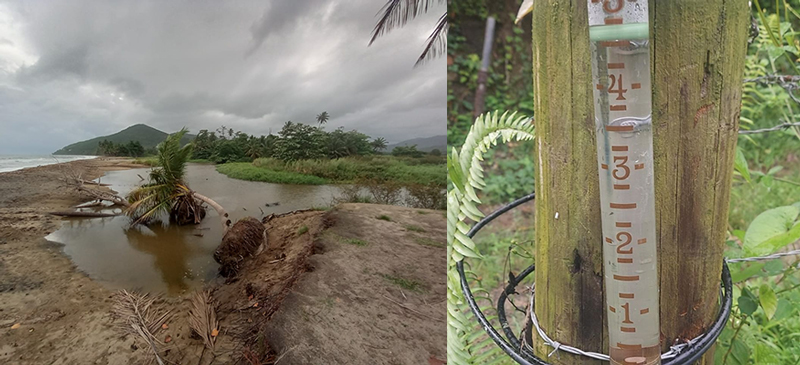
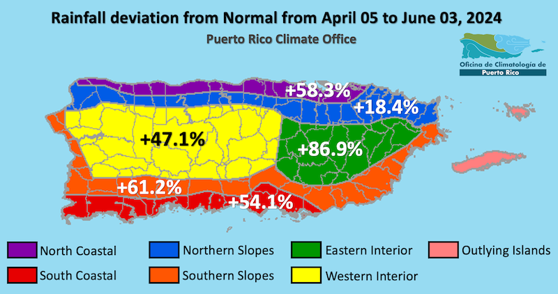
- Puerto Rico Conditions: Several rain events were observed across Puerto Rico. In fact, there was so much rain that significant flooding was reported across many municipalities of the interior and west. May rainfall amounts generally exceeded 150% to 200% of normal. The only water reservoir that was not at optimal levels quickly recovered, and all of the streams monitored by the U.S. Geological Survey were at near-normal to above-normal flows. Additionally, the San Juan area climate monitoring station registered the second wettest first five months of the year, with 32.90 inches since January 1. This is the wettest first 5 months of the year in over 120 years, with only 1902 (36.68 inches) being wetter. Paraiso in the Ceiba Municipio has seen over 51 inches of rain so far this year. Taking all these factors into consideration, the remaining drought affecting the eastern interior and northwestern Puerto Rico was completely erased.
- U.S. Virgin Islands (USVI) Conditions: Very wet conditions were observed across the U.S. Virgin Islands, especially St. Croix. Reports from the CoCoRaHS network show two stations near Christiansted have seen more than 32 inches of rain year to date through May 31. This is the wettest first five months on record for any station in St. Croix, dating back to 1921. Stations in St. John show the second wettest year to date since 1983. St. Thomas is also much wetter than normal. The National Weather Service (NWS) Cooperative Observer Program (COOP) site at East End in St. Croix observed its second wettest start of the year, with 20.14 inches collected since January 1. All these rains were reflected in significantly improved well levels. Therefore, Abnormally Dry (D0) conditions were removed from St. Thomas, leaving all islands free from drought. Groundwater levels are recovering from drought across all three islands.
- Puerto Rico Impacts: In general, farmers in the western mountainous region and eastern region reported continued rain since the beginning of May. Some experienced flooding, highwater saturation, high pest pressure, and limited access to the roads, which limited their work and production. Though rain activity eased in the end of May and beginning of June, farmers and ranchers in the northern and central interior region are experiencing oversaturation in the soil. This, combined with high heat, has caused health and wellness concerns for those working the land. Some areas in the south have experienced rainy conditions, with an exception in Guayama, which had drier than normal conditions this season.
- U.S. Virgin Islands (USVI) Impacts: Recent rains helped ponds fill up and vegetation to bounce back. Flooding and landslides caused some erosion to farms and crop loss. While drought is not currently impacting the USVI and recent rains helped the vegetation, ranchers and farmers expressed concern that heat and high winds can bring back dry conditions.
- Looking Ahead: The NWS Climate Prediction Center's seasonal outlook calls for no drought development in the next three months. Additionally, the latest long range guidance indicates that above-normal precipitation will persist across the northeastern Caribbean for the next few months. Usually, the islands experience a mid-summer drought during the month of June, but the rainy season kicks off by mid-July to the end of July.
- For weather information specific to your area, please monitor products issued by the National Weather Service in San Juan.
- View active National Weather Service Drought Information Statements, including for Puerto Rico and the U.S. Virgin Islands.
See below for additional details on rainfall, soil moisture, and streamflow conditions, temperature trends, impacts, and outlooks.
U.S. Drought Monitor map for Puerto Rico and the U.S. Virgin Islands, as of June 4, 2024. The U.S. Drought Monitor is updated each Thursday to show the location and intensity of drought across the country.
The map uses 5 classifications: Abnormally Dry (D0), showing areas that may be going into or are coming out of drought, and four levels of drought (D1–D4).
A drought index combines multiple drought indicators (e.g., precipitation, temperature, soil moisture) to depict drought conditions. For some products, like the U.S. Drought Monitor, authors combine their analysis of drought indicators with input from local observers. Other drought indices, like the Standardized Precipitation Index (SPI), use an objective calculation to describe the severity, location, timing, and/or duration of drought.
Learn MorePeriods of drought can lead to inadequate water supply, threatening the health, safety, and welfare of communities. Streamflow, groundwater, reservoir, and snowpack data are key to monitoring and forecasting water supply.
Learn MoreDrought can reduce the water availability and water quality necessary for productive farms, ranches, and grazing lands, resulting in significant negative direct and indirect economic impacts to the agricultural sector. Monitoring agricultural drought typically focuses on examining levels of precipitation, evaporative demand, soil moisture, and surface/groundwater quantity and quality.
Learn MoreU.S. Drought Monitor
D0 - Abnormally Dry
Abnormally Dry (D0) indicates a region that is going into or coming out of drought, according to the U.S. Drought Monitor. View typical impacts by state.
D1 – Moderate Drought
Moderate Drought (D1) is the first of four drought categories (D1–D4), according to the U.S. Drought Monitor. View typical impacts by state.
D2 – Severe Drought
Severe Drought (D2) is the second of four drought categories (D1–D4), according to the U.S. Drought Monitor. View typical impacts by state.
D3 – Extreme Drought
Extreme Drought (D3) is the third of four drought categories (D1–D4), according to the U.S. Drought Monitor. View typical impacts by state.
D4 – Exceptional Drought
Exceptional Drought (D4) is the most intense drought category, according to the U.S. Drought Monitor. View typical impacts by state.
U.S. Drought Monitor map for Puerto Rico and the U.S. Virgin Islands, as of June 4, 2024. The U.S. Drought Monitor is updated each Thursday to show the location and intensity of drought across the country.
The map uses 5 classifications: Abnormally Dry (D0), showing areas that may be going into or are coming out of drought, and four levels of drought (D1–D4).
The U.S. Drought Monitor is updated weekly on Thursday morning, with data valid through that Tuesday at 7 a.m. ET.
A drought index combines multiple drought indicators (e.g., precipitation, temperature, soil moisture) to depict drought conditions. For some products, like the U.S. Drought Monitor, authors combine their analysis of drought indicators with input from local observers. Other drought indices, like the Standardized Precipitation Index (SPI), use an objective calculation to describe the severity, location, timing, and/or duration of drought.
Learn MorePeriods of drought can lead to inadequate water supply, threatening the health, safety, and welfare of communities. Streamflow, groundwater, reservoir, and snowpack data are key to monitoring and forecasting water supply.
Learn MoreDrought can reduce the water availability and water quality necessary for productive farms, ranches, and grazing lands, resulting in significant negative direct and indirect economic impacts to the agricultural sector. Monitoring agricultural drought typically focuses on examining levels of precipitation, evaporative demand, soil moisture, and surface/groundwater quantity and quality.
Learn MoreCurrent and Future Drought Conditions
Drought Conditions
- Puerto Rico: All of Puerto Rico is free of dryness or drought conditions.
- U.S. Virgin Islands: All of the U.S. Virgin Islands are free of dryness or drought conditions.
Sector Impacts
To report the effects of dry and wet conditions on your farm projects for future drought updates, use the Condition Monitoring Observations and Reports (CMOR) tool or join the Caribbean Climate Hub reporter group chat on WhatsApp.
Agricultural Conditions
- Puerto Rico:
- Farmers in the central interior region (Cidra, Barranquitas, Naranjito), experienced constant rain in the month of May. The soil has been saturated, which limits tasks such as tilling and soil preparation. Some farmers experienced slightly drier conditions in June compared to the beginning and middle of May. Intermittent rain at night was observed.
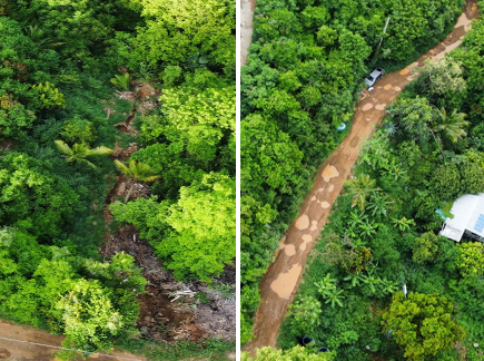
- In the northern region (Manatí, San Juan, and Toa Alta), rainy conditions have been observed for several weeks in the last two months. The region received large amounts of rain by early May. There were floods on the terrain and access roads, which made farm operations on the ground difficult. Rainfall has eased over the past week, with conditions a little drier and mistier. The frequent heat made certain tasks difficult.
- A farmer in the northeastern region (Canóvanas), experienced intense continued rain after a continued dry season. The conditions limited farm tasks and access.
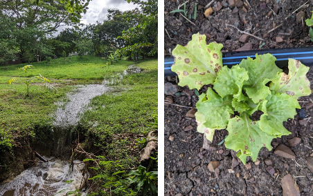
- Farmers and ranchers in the south eastern region (San Lorenzo, Maunabo, Humacao, Yabucoa, Patillas, Arroyo) reported that soil has been saturated for weeks, so much so that holes made in the ground rapidly fill with water. Land flooded with water. Some experienced erosion, flooding, and saltwater intrusion on coastal lands. Others noticed negative effects on their production due to the combination of heavy rains and high heat indices, which have affected the health of their crops.
- In the southern region (Guayama, Coamo, and Ponce), conditions were slightly drier than usual for mid-May compared to other years. A citizen scientist reported a rainfall of 2.38 inches for May, when the average is 2.98 inches. No heavy rains have been felt compared to other areas. In contrast, in Coamo, the rains were beneficial for farm and gardening tasks, allowing the soil to stay more humid than normal. Rain and temperature fluctuations correlate with more stress and susceptibility to crop pests. There were periods of heavy rainfall followed by periods of no rainfall.
- The southwestern region (Cabo Rojo, Lajas, Guánica, and Yauco) had a consistent rainfall pattern, as reported by a rancher, with an average of 3 to 4 rainfall events per week. He recorded an average of 2 to 3 inches of rainfall each week in May. The pastures successfully recovered from past drought. Some farmers reported reaching new precipitation records within their properties. Hay-producing farmers observed a decrease in the marketing of their products due to the low demand. Some also experienced major flooding as a result of said rainfall, which prevented access to their farms and therefore delayed their daily operations.
- In the western mountainous region (Maricao and Moca), intense and constant rain fell since April. There were few days without rain episodes. Farmers experienced high heats. Cloudy conditions were constantly observed.
- St. Thomas: Farmers in St. Thomas report that ponds are full and rain helped the vegetation to bounce back, which is good news for livestock and poultry farmers who need access to feed. Numerous landslides have been reported on farm roads and through farms in the Bordeaux area. Intermittent heavy rains, combined with soil conditions that developed due to long-term drought, created impacts such as landslides and significant erosion, especially related to roads. Farmers lost crops. In addition, flooding created a new gully through several farmers’ properties. This created further hardship for farmers working in already harsh conditions. During the April–May period, a network of volunteer CoCoRaHS observers on St. Thomas reported precipitation ranging from 13.32 to 17.07 inches, with much of the rain falling in short, intense bursts. Residents also report intermittent windy weather, further adding to the issues faced by farmers. Farmers also reported that heat returns when the rain stops for more than a few weeks, and the ground and soil become immediately distressed. Some farmers are planting, and others are cleaning up acreage or assessing crop losses due to floods. All are working on land management practices to aid them during non-drought periods. In addition to the flooding and crop losses, livestock farmers are struggling with increasing prices. A 50-pound sack of grain has risen in price by $3 to $5 per bag, further impacting their bottom line. St. Thomas farmers are concerned as they are impacted due to the abattoir facilities on St. Croix have been shut down for some time due to ongoing repairs. Those abattoir concerns extend to the other islands.
- St. John: Row and specialty crop farmers on St. John had heavy rain, and there are mold, mildew, and crop losses due to the deluge. While vegetation is bouncing back from earlier drought, the soil is showing signs of distress due to flooding. Many producers are currently focusing on storm clean-up, after some areas were submerged during spring storms. Other producers are preparing land, while many are working on planting microgreens, fruit trees, quick crops, and rotating crops to keep up production. Volunteer (CoCoRaHS) observers on St. John reported April–May rainfall ranging from 9.77 to 14.53 inches. The observer at Windswept Beach received 22.95 inches of rain during the first 5 months of 2024, the wettest January–May period in that location since 1986, when 25.28 inches fell.
- St. Croix: Farmers have seen heavy rains and flooding, which is damaging crops. Crop losses have occurred across St. Croix. Many farmers report intermittent showers create soil loss. As soon as the soil dries up, and high winds hit, they are back where they started, with increased impacts of climate due to heavy and prolonged rain. Currently, livestock farmers are working to plan for feed shortages later in the year due to a lack of grass during the hotter months. Many are also buying grain to supplement their feed when feed is available. For poultry farmers, egg production was impacted due to flooding. The U.S. Virgin Islands Department of Agriculture (VIDA) reduced water deliveries on St. Croix from more than 649,790 gallons in April to around 390,770 gallons of water in May, which helped increase overall water access to low-resource farmers who would normally buy water as the USVI moves into the hotter months.
- Assistance for USVI farmers and ranchers: According to the U.S. Department of Agriculture, St. Croix and St. Thomas already qualified for a 2023 secretarial drought disaster declaration, based on the U.S. Drought Monitor (USDM). Similarly, livestock producers in St. Croix and St. Thomas qualified for direct assistance through the USDM-driven Livestock Forage Program (LFP). LFP assistance begins when Severe Drought (D2) lasts 8 weeks or more, with payments tripling when the Extreme Drought (D3) threshold is reached, and quadrupling upon spending 4 weeks at D3 or attaining Exceptional Drought (D4).
Rainfall Trends
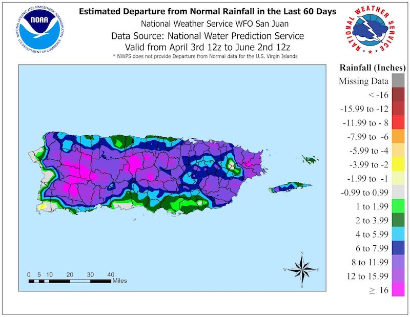
Almost all of Puerto Rico observed above-normal rainfall in the past 60 days. Areas across western Puerto Rico collected more than 20 inches above the climatological mean, but in general, 4 to 10 inches above normal were observed.
Soil Moisture Conditions in Puerto Rico
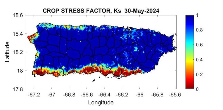
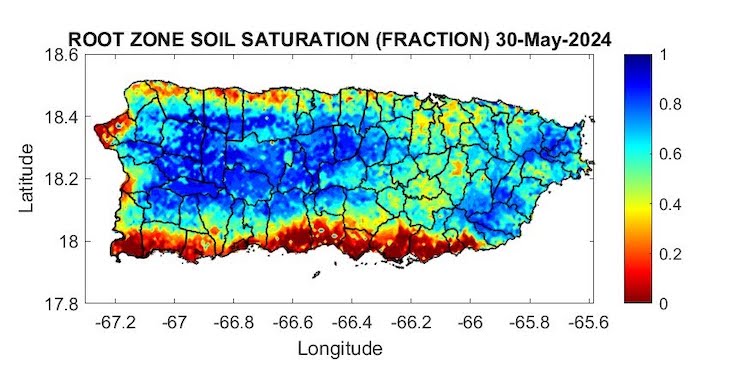
The latest soil moisture data from the Puerto Rico Agricultural Water Management (PRAGWATER) indicates that dry soils persist along the southern plains of Puerto Rico, from Patillas to Cabo Rojo, and across portions of Mayagüez, Rincón, and Aguada. Some dryness is also visible across the northern plains, from Aguadilla through the San Juan metropolitan area. The rest of the soils have healthy levels of moisture (Figures 3 and 4).
Streamflow and Groundwater Conditions in Puerto Rico
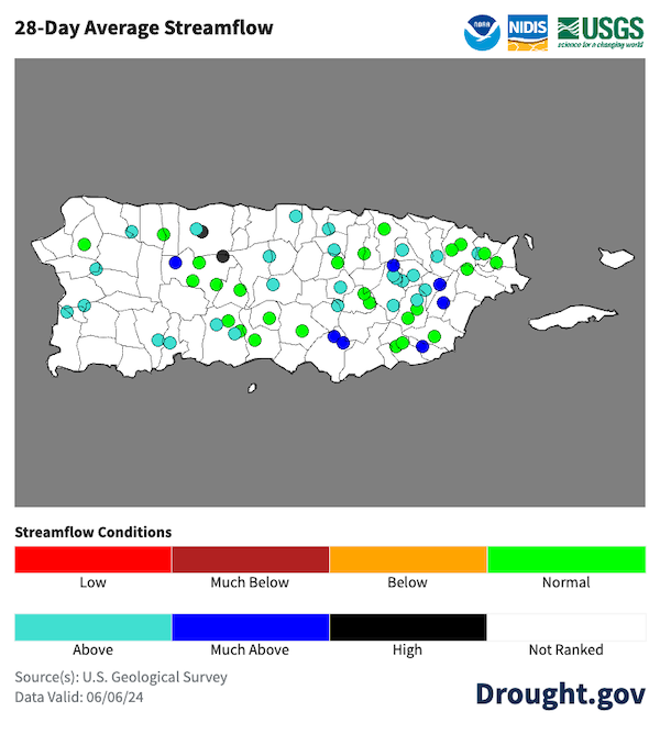
The 28-day average streamflow from the U.S. Geological Survey (USGS) river gage network (Figure 5) indicates that rivers are running near normal to high across all of Puerto Rico. Streams are also drying out in the west. View information on groundwater levels along the South Coast of Puerto Rico, or view current USVI groundwater conditions.
Temperature Trends
Due to record warm sea surface temperatures in both the Caribbean Sea and the southern Atlantic Ocean, 2024 is on pace to be the warmest year on record for San Juan. On May 31, the average temperature of 81.3°F was running 0.2°F warmer than 1983, making it the hottest on record.
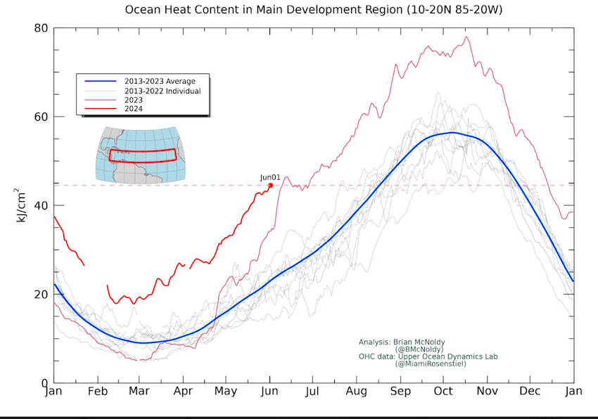
On June 1, the first day of the Atlantic Basin Hurricane season, the ocean heat content for the area between 10N to 20N latitude and 20W to 85W longitude (i.e., the Main Development Region) is at a record warm value, and is as high as it normally would be on August 17 (Figure 6).
Outlooks
Seasonal Drought Outlook
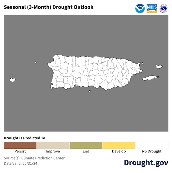
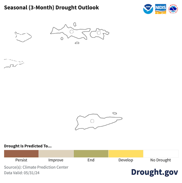
The NWS Climate Prediction Center’s Seasonal Drought Outlook (Figures 7–8) does not show developing drought in Puerto Rico or the U.S. Virgin Islands during the next three months.
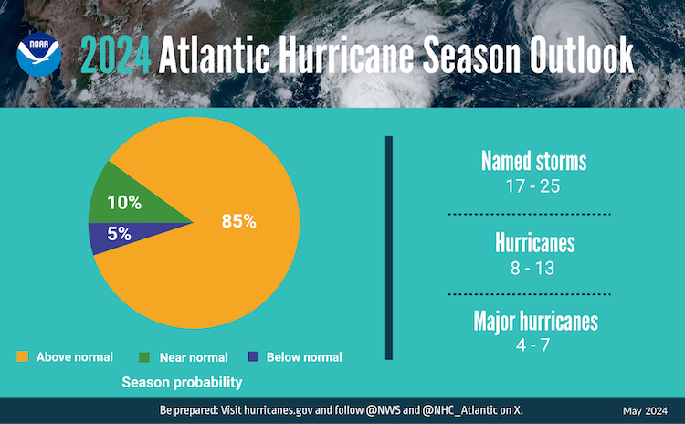
Hurricane Outlook
NOAA predicts above-normal hurricane activity in the Atlantic basin this year. NOAA’s outlook for the 2024 Atlantic hurricane season, which spans from June 1 to November 30, predicts an 85% chance of an above-normal season, a 10% chance of a near-normal season, and a 5% chance of a below-normal season. This prediction is due to several factors, including near-record warm ocean temperatures in the Atlantic Ocean, development of La Niña conditions in the Pacific, reduced Atlantic trade winds and less wind shear, all of which tend to favor tropical storm formation. View more information on the 2024 Hurricane Outlook.
For More Information
- National Weather Service (NWS) Weather Forecast Office – San Juan: Climate and Drought Information
- NWS Drought Information Statements for Puerto Rico and the U.S. Caribbean
- Drought.gov:
- Caribbean Drought Bulletins. Caribbean Regional Climate Center, Caribbean Institute for Meteorology and Hydrology (CIMH), Barbados
- U.S. Department of Agriculture (USDA) Caribbean Climate Hub drought and disaster assistance resources for tropical forestry and agriculture
Prepared By
Emanuel Rodriguez and Odalys Martinez
National Weather Service San Juan Weather Forecast Office
Héctor J. Jiménez
Office of Climatology, University of Puerto Rico
Meredith Muth
NOAA National Integrated Drought Information System (NIDIS)
Victor Murphy
National Weather Service Southern Region
Christina Chanes
University of the Virgin Islands
Silmarie Crespo Vélez and Nora Álvarez-Berríos
USDA Caribbean Climate Hub, USFS International Institute of Tropical Forestry
Brad Rippey
USDA Office of the Chief Economist
Timothy Dalrymple
USGS Caribbean – Florida Water Science Center (CFWSC)
Puerto Rico Reporting Input: Thanks to the Agricultural Extension Service, College of Agricultural Sciences, University of Puerto Rico-Mayaguez, Victus Puerto Rico, South West Soil and Water Conservation District, Eastern Soil and Water Conservation District, and the Association of Cattle Ranchers, Buena Tierra organic Farm, Moriviví Farm, and Gosén Farm. Special thanks to agronomists, scientists, ranchers, and farmers: Alejandro Marengo Casul, Alejandro Miró, Daniel García, Diana Guzmán-Colón, Elvin Lebrón, Javier Medina Sánchez, Joshua Ortíz, Luz Dahlia Jiménez, Mariela Butler, Harry Ramírez, Merari Torres Amaro, Samuel Rodríguez, Santiago Acosta, Viviana Medina
USVI Reporting Input: Several individuals contributed to this report and we are acknowledging the following for their support including the farming community across the USVI, UVI faculty, staff, and collaborators of the UVI Department of Chemical and Physical Sciences, UVI Etelman Observatory, UVI Agricultural Experiment Station, VI Department of Agriculture, as well as the USDA Office Chief Economist, National Parks Service in St. Croix and St John, VI Department of Planning and Natural Resources, USDA Farm Service Agency, USDA Natural Resources Conservation Services in St. Croix, Coral Bay Community Council and the many volunteer drought reporters, volunteers, and farmers from across the territory.
About This Report
This drought update is issued in partnership between the National Integrated Drought Information System (NIDIS), National Oceanic and Atmospheric Administration (NOAA) National Weather Service, the U.S. Department of Agriculture (USDA), and the University of the Virgin Islands. The purpose of the update is to communicate a potential area of concern for drought expansion and/or development within Puerto Rico and the U.S. Virgin Islands based on recent conditions and the upcoming three-month forecast.
NIDIS and its partners will issue these updates every two months. Subscribe for these U.S. Caribbean drought updates here.
