Rain has kept drought away from Puerto Rico and the U.S. Virgin Islands—but dryness is appearing in some areas. No widespread drought is predicted for this spring.
Key Points
- Regional: As the northeastern Caribbean dry season progresses, strong trade winds have increased the frequency of rain showers across eastern and northern Puerto Rico and the U.S. Virgin Islands, keeping the soils wet and water storage sufficient. In contrast, rainfall activity was limited for the southern and western portions of Puerto Rico.
- Puerto Rico Impacts: Seasonally dry conditions are observed in the southern plains, while a drying trend began in the northwestern portion of Puerto Rico, with impacts to vegetation health and crops. Water amounts are diminishing across the U.S. Geological Survey’s monitored wells in the south and for the Guajataca Dam in the northwest. High winds and dry conditions in the southwest have led to increased fire activity and elevated fire weather conditions for the southern plains and west coast of Puerto Rico.
- USVI Impacts: Rain continues to improve groundwater levels on St. Thomas and St. Croix. St. John had a small loss of groundwater in the last month but overall is still quite wet.
- Looking ahead: Above-normal temperatures and near-normal or slightly above-normal precipitation are expected for spring. No widespread drought is expected to develop, but Abnormally Dry (D0) conditions may appear across the southern plains and northwest Puerto Rico, and in the U.S. Virgin Islands.
See below for additional details on current conditions, impacts (including streamflow and soil moisture), and outlooks.
U.S. Drought Monitor map for Puerto Rico and the U.S. Virgin Islands, as of February 25, 2025. The U.S. Drought Monitor is updated each Thursday to show the location and intensity of drought across the country.
The map uses 5 classifications: Abnormally Dry (D0), showing areas that may be going into or are coming out of drought, and four levels of drought (D1–D4).
A drought index combines multiple drought indicators (e.g., precipitation, temperature, soil moisture) to depict drought conditions. For some products, like the U.S. Drought Monitor, authors combine their analysis of drought indicators with input from local observers. Other drought indices, like the Standardized Precipitation Index (SPI), use an objective calculation to describe the severity, location, timing, and/or duration of drought.
Learn MorePeriods of drought can lead to inadequate water supply, threatening the health, safety, and welfare of communities. Streamflow, groundwater, reservoir, and snowpack data are key to monitoring and forecasting water supply.
Learn MoreDrought can reduce the water availability and water quality necessary for productive farms, ranches, and grazing lands, resulting in significant negative direct and indirect economic impacts to the agricultural sector. Monitoring agricultural drought typically focuses on examining levels of precipitation, evaporative demand, soil moisture, and surface/groundwater quantity and quality.
Learn MoreU.S. Drought Monitor
D0 - Abnormally Dry
Abnormally Dry (D0) indicates a region that is going into or coming out of drought, according to the U.S. Drought Monitor. View typical impacts by state.
D1 – Moderate Drought
Moderate Drought (D1) is the first of four drought categories (D1–D4), according to the U.S. Drought Monitor. View typical impacts by state.
D2 – Severe Drought
Severe Drought (D2) is the second of four drought categories (D1–D4), according to the U.S. Drought Monitor. View typical impacts by state.
D3 – Extreme Drought
Extreme Drought (D3) is the third of four drought categories (D1–D4), according to the U.S. Drought Monitor. View typical impacts by state.
D4 – Exceptional Drought
Exceptional Drought (D4) is the most intense drought category, according to the U.S. Drought Monitor. View typical impacts by state.
U.S. Drought Monitor map for Puerto Rico and the U.S. Virgin Islands, as of February 25, 2025. The U.S. Drought Monitor is updated each Thursday to show the location and intensity of drought across the country.
The map uses 5 classifications: Abnormally Dry (D0), showing areas that may be going into or are coming out of drought, and four levels of drought (D1–D4).
The U.S. Drought Monitor is updated weekly on Thursday morning, with data valid through that Tuesday at 7 a.m. ET.
A drought index combines multiple drought indicators (e.g., precipitation, temperature, soil moisture) to depict drought conditions. For some products, like the U.S. Drought Monitor, authors combine their analysis of drought indicators with input from local observers. Other drought indices, like the Standardized Precipitation Index (SPI), use an objective calculation to describe the severity, location, timing, and/or duration of drought.
Learn MorePeriods of drought can lead to inadequate water supply, threatening the health, safety, and welfare of communities. Streamflow, groundwater, reservoir, and snowpack data are key to monitoring and forecasting water supply.
Learn MoreDrought can reduce the water availability and water quality necessary for productive farms, ranches, and grazing lands, resulting in significant negative direct and indirect economic impacts to the agricultural sector. Monitoring agricultural drought typically focuses on examining levels of precipitation, evaporative demand, soil moisture, and surface/groundwater quantity and quality.
Learn MoreThis update is based on data available as of Thursday, February 27, 2025. We acknowledge that conditions are evolving.
Current Drought and Climate Conditions
- Puerto Rico and the U.S. Virgin Islands have been drought free since late April 2024 and late February 2024, respectively.
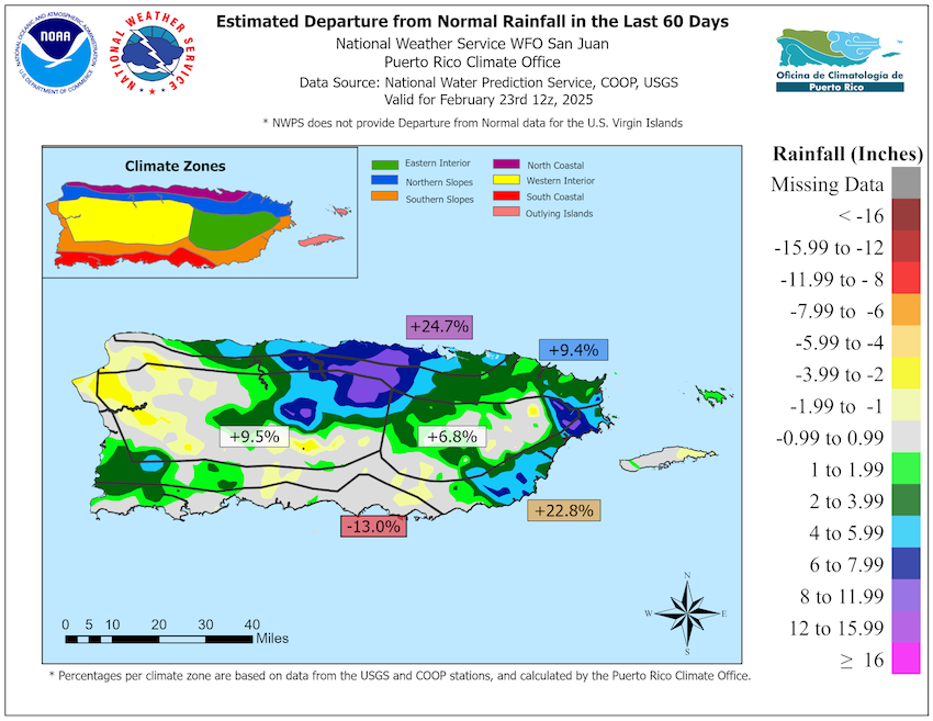
- In Puerto Rico, above-normal rainfall has been observed for most of the east, eastern interior, and northeast sections. However, rainfall deficits are beginning to increase in the southern plains, and more noticeably, in the northwest. While most streams are running near normal, water is being depleted from the wells in southern Puerto Rico and from Guajataca Dam in the northwest. Additionally, concerns for fire ignition and spreading are increasing in these areas, which have drier soils. Nevertheless, Abnormally Dry (D0) conditions have not developed yet, as this dryness is considered typical for the early months of the year. In areas where soils are dry, vegetation is showing signs of stress.
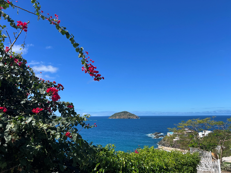
- Rainfall amounts are in the normal range, based on data collected from the CoCoRaHS network, which is keeping the soils wet and the vegetation healthy. In the U.S. Virgin Islands, recent intermittent rains have improved groundwater levels on St. Thomas and St. Croix. St John has had a small loss of groundwater in the last month but overall is still quite wet. To view U.S. Geological Survey (USGS) monitoring well levels, visit the USGS Virgin Islands water conditions page.
Rainfall Continues to Remain Typical for Most of Puerto Rico
Impacts for Puerto Rico and the U.S. Virgin Islands
Agriculture Impacts
- Report your Impacts: To report the effects of dry conditions on your farm projects for future Drought Updates, use the Drought Condition Monitoring Observations and Reports (CMOR) tool or join the USDA Caribbean Climate Hub reporter group chat on WhatsApp.
- Puerto Rico:
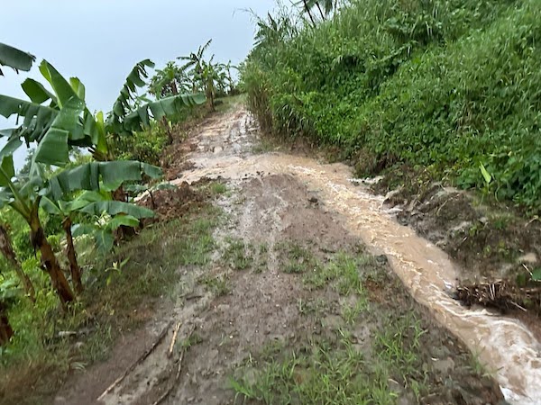
- Central interior region (Caguas, Adjuntas, Barranquitas, Ciales, Cidra, Aguas Buenas): Farmers report conditions have remained humid due to persistent rain from December to mid-February, which has only started to diminish and dry in the last week. Above-normal rainfall for this time of year has affected agricultural management, with wet conditions making it difficult for vehicles to access farms and compromising the safety of workers. In some areas, excessive humidity has affected the harvesting processes, caused landslides and erosion, and increased problems with fungus, bacteria, and root rotting. There have been benefits to the increased winter rain, which has favored non-irrigated crops such as bananas.
- Northern region (Barceloneta): Farmers report the months of January and early February were rainy, with no significant dry period in January. This increased precipitation has favored crop growth compared to the previous year. However, excess rain affected access to farm roads and tasks such as weeding and pruning, especially on sloping terrain. This week, precipitation decreased, allowing the ground to start to dry out.
- Northeast region (Canovanas, Fajardo): Farmers report that after more than a month of constant rain, conditions have begun to dry out in some areas. January was particularly wet, more than usual for the season. The persistent humidity caused limitations in road access to farms. This prevented maintenance and harvest work and, in some cases, caused the loss of crops, such as cacao.
- Eastern Municipal Islands (Culebra and Vieques): Extension agent reports indicate that in Vieques, soils are beginning to dry out due to the lack of precipitation and cooler and drier northeasterly winds. Although January was wetter than in previous years, the dry season began in February. Weed management has increased to conserve water, as weeds consume what little water is available, leading to increased operational costs. In Culebra, the dryness is more prominent because the soils do not have good natural water retention and require intensive conservation practices to prevent soil and water loss. There is one active fire in Vieques.
- Eastern region (Yabucoa, Las Piedras): Farmers in the area have been experiencing persistent, heavy rain. High soil humidity has increased the incidence of fungi, such as yellow Sigatoka, on bananas. In the livestock sector, grazing areas have been affected by large amounts of rain, resulting in increased soil erosion. The livestock producers in the area are also concerned the incidence of fungi and diseases in herds may increase with humid conditions. However, areas dedicated to grass and hay have been favored by this weather with vigorous growth.
- Southern region (Coamo, Salinas, Guayama, Arroyo): Generally, conditions have been dry in recent weeks, with no rain since February 2, requiring consistent irrigation to maintain crops. Conditions are variable across the region, however, and in Arroyo, a farmer reports that conditions remain normal, even wetter than usual, with trees in good condition and no need for irrigation. There is currently a fire danger statement. High winds and drying conditions are making grasslands and shrublands more conducive for the ignition and spread of wildfires.
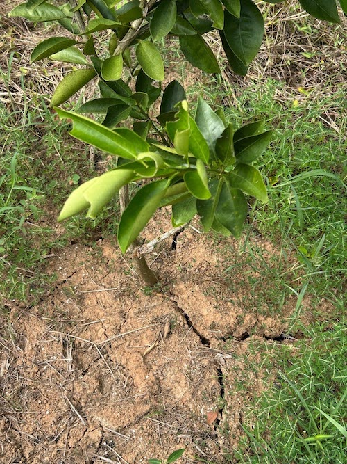
- Southwest region (Guánica, Lajas, San German): The weather has been typical for the season, slightly drier, but with some downpours that have lightened the dryness. So far, conditions are not significantly affecting agricultural activities. However, some farmers in San German have observed cracks in the ground and lost fruit trees due to water stress. High winds and drier conditions are conducive for the ignition and spread of wildfires, and there is currently a risk of fire for dry forested lands in Guánica and across the south.
- Western region (Las Marías, San Sebastián, Mayagüez, Moca): Dry conditions have been extreme in some areas, with up to 60 days without significant rain. This has made it difficult to plant and maintain crops such as bananas, citrus fruits, and cacao, with losses of young plants and water stress evident in the trees. In San Sebastián, after a week and a half without rain, the ground has begun to crack at the surface, although the subsoil still maintains some moisture. Because of the lack of rain, many growers have had to stop their work or depend on irrigation systems to maintain their crops and pastures. On the other hand, some have adjusted their planting practices, taking advantage of the lack of humidity to grow vegetables and beans, which are less sensitive to pests and diseases during times of low humidity.
- U.S. Virgin Islands:
- St. Thomas: Farmers reported full ponds due to recent storms, and the rain has helped vegetation. Livestock and poultry farmers have access to feed. Guinea grass is drying up due to high winds. Increased rains and saturated soils are resulting in landslides and significant road erosion.
- St. John: Row and specialty crop farmers report heavy and intermittent rain. Some soils are showing signs of distress due to general moisture losses from heat and windy conditions. In January, many focused on clean-up because their farms were submerged underwater during the storms. Some farmers are working on planting microgreens, fruit trees, and quick crops to keep production up and are also rotating crops to prepare for hotter summer months.
- St. Croix:Many farmers are reporting intermittent rains and showers, which is leading to the loss of soil from erosion. Livestock farmers experiencing high winds are working to plan for feed shortages, which will occur later in the year due to a lack of grass during the hotter months.
Soils Are Drying Out Due to Lack of Rain in Las Marías, Puerto Rico
Heavy Rains in Central and Eastern Puerto Rico Cause Road Erosion
No Signs of Dryness in the U.S. Virgin Islands
Puerto Rico Streamflow and Soil Moisture Impacts
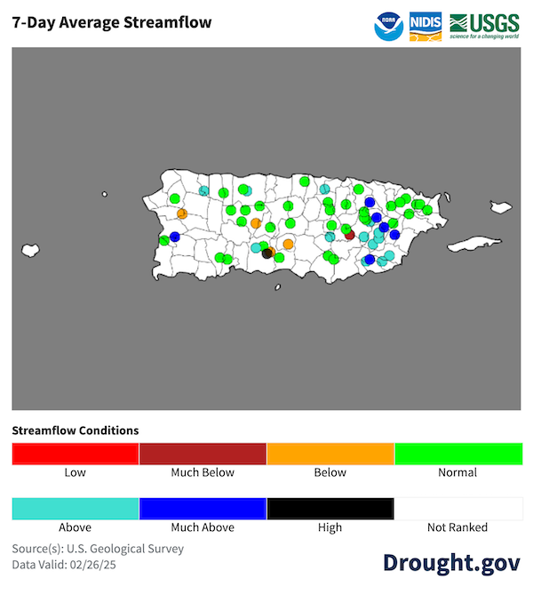
- Most rivers are running near normal or even above normal across most of Puerto Rico. Signs of dryness are beginning to appear in some streams, particularly those around Ponce, Villalba, Cidra, Juncos, Trujillo Alto, and Fajardo.
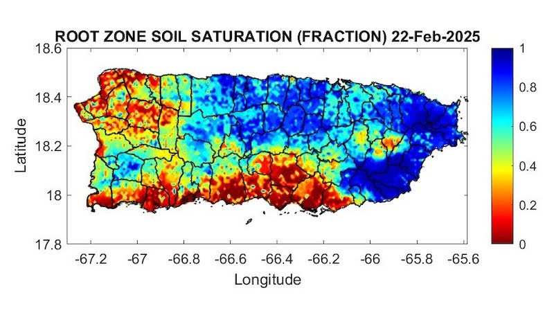
- Frequent showers led to wet soils across most of the eastern and north-central portions of Puerto Rico. However, these rains were not as common in the northwest and the southern hills of south-central Puerto Rico, where both satellite-derived products and observations from farmers and spotters show dry soils.
- In areas where soils are dry, vegetation is showing signs of stress. Trees and pastures along the south, especially from Salinas to Sabana Grande, already have a yellowish appearance.
Soils Are Drying in Southern and Northwestern Puerto Rico
River Flow Levels Are Mostly Normal in Puerto Rico
Most Vegetation Is Healthy Across Puerto Rico, with Some Areas of Dryness

Outlooks and Potential Impacts for Puerto Rico and the U.S. Virgin Islands
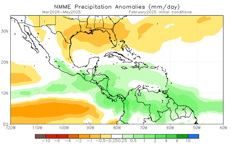
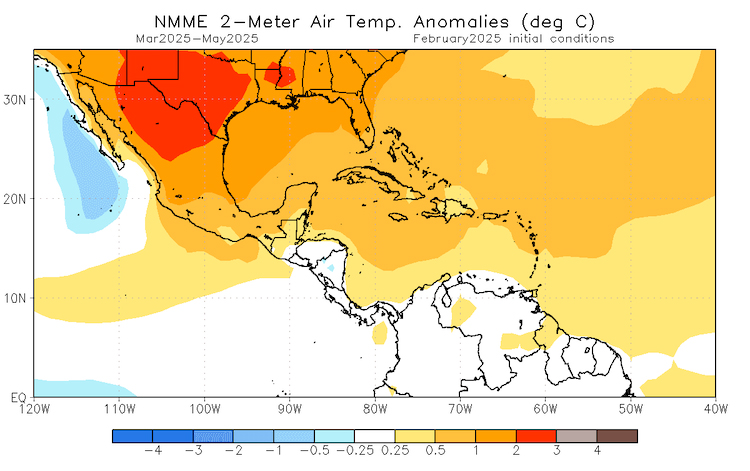
- The North American Multi-Model Ensemble for spring (March–May 2025) indicates a 40% to 50% chance of observing slightly wetter-than-normal conditions for portions of Puerto Rico, with near-normal conditions forecast for the Virgin Islands. Additionally, there is a greater than 70% chance that temperatures will remain above normal through the spring season.
- No drought is expected to develop over the next three months in Puerto Rico or the U.S. Virgin Islands, according to the NOAA Climate Prediction Center’s current Seasonal Drought Outlook. However, Abnormally Dry (D0) conditions may appear across the southern plains and northwestern Puerto Rico in light of increasing summer temperatures as we transition between seasons.
Spring Is Expected to Be Wet and Warm
Additional Resources
National Weather Service Weather Forecast Offices:
- San Juan Climate and Drought Information
- Puerto Rico and U.S. Virgin Islands Fire Weather Information
- National Weather Service Drought Information Statements
U.S. Drought Portal (Drought.gov):
USDA Caribbean Climate Hub: Drought and disaster assistance resources for tropical forestry and agriculture
Southeast Regional Climate Center: Quarterly Climate Impact and Outlook Reports, which includes Puerto Rico and U.S. Virgin Islands.
Prepared By
Emanuel Rodríguez-González
NOAA National Weather Service Weather Forecast Office San Juan
William A. Gould, Nohely Reyes-Pérez, Viviana Medina-Rodríguez
U.S. Department of Agriculture (USDA) Caribbean Climate Hub, USDA Forest Service Research and Development
Héctor J. Jiménez
University of Puerto Rico Office of Climatology
Christina Chanes
University of the Virgin Islands
Meredith Muth
NOAA National Integrated Drought Information System (NIDIS)
Victor Murphy
NOAA National Weather Service Southern Region
Brad Rippey
USDA Office of the Chief Economist
Elliot Sosa
U.S. Geological Survey Caribbean–Florida Water Science Center (CFWSC)
Puerto Rico Reporting Input: Thanks to the Agricultural Extension Service, College of Agricultural Sciences, University of Puerto Rico-Mayagüez, Eastern Soil and Water Conservation District, the Association of Cattle Ranchers, Hacienda Terruño, Hacienda Chocolat, De Mi Tierra A Mi Pueblo, Plenitud Puerto Rico, and Cafe Xiojana. Special thanks to agronomists, extension agents, ranchers, and farmers: Kevin Ramirez, Rebekah Sanchez, Josue Gonzalez, Jonathan Gonzalez, Samuel Rodriguez, Rey Cruz, Iris Jannette Rodriguez, Manuel Candelaria Carrion, Diana Guzmán-Colón, Silmarie Crespo-Velez, Bernabe Martir, Hilda Bonilla, Luz Dahlia Jiménez, Roy Rodriguez, Jorge A. Reyes Medina, Angel Lucena, Elvin Cortes,Micelio, and others.
USVI Reporting Input: Several individuals contributed to this report, and we acknowledge the following for their support: the farming community across the USVI, UVI faculty, staff, and collaborators of the UVI Department of Chemical and Physical Sciences, UVI Etelman Observatory, UVI Agricultural Experiment Station, VI Department of Agriculture, as well as the USDA Office Chief Economist, National Parks Service in St. Croix and St. John, VI Department of Planning and Natural Resources, USDA Farm Service Agency, USDA Natural Resources Conservation Service in St. Croix, Coral Bay Community Council, and the many volunteer drought reporters, volunteers, and farmers from across the territory.
About This Report
This drought update is issued in partnership between the National Integrated Drought Information System (NIDIS), National Oceanic and Atmospheric Administration (NOAA) National Weather Service, the U.S. Department of Agriculture (USDA), and the University of the Virgin Islands. The purpose of the update is to communicate a potential area of concern for drought expansion and/or development within Puerto Rico and the U.S. Virgin Islands based on recent conditions and the upcoming three-month forecast.
NIDIS and its partners will issue these updates every two months. Subscribe for these U.S. Caribbean drought updates here.
