Next month’s Southeast Monthly Climate Webinar is on Tuesday, April 13 at 10 am ET, with a special presentation on the Spring Flood Outlook. Watch the March 9 webinar recording, and register for upcoming webinars.
Climate Conditions and Outlooks
- Winter had an atypical La Niña pattern due to the Arctic Oscillation and Polar Vortex. A good description is found here.
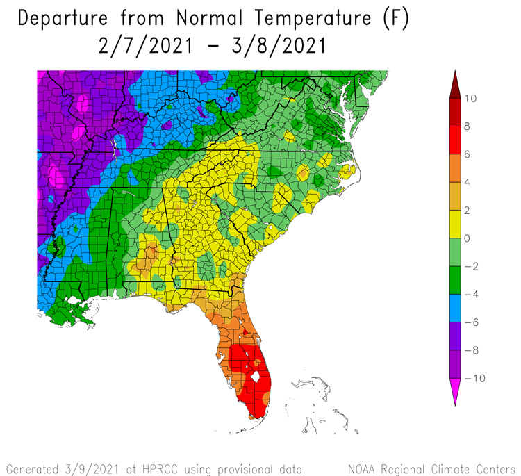
- February had near-average temperatures, with above-average temperatures for Florida.
- February precipitation was variable for the region, with above-average precipitation for eastern South Carolina and southern Georgia, and below-average for Alabama.
- February severe weather included an EF-3 Tornado in North Carolina.
- A La Niña Advisory is still in affect, with a potential transition to neutral during spring (60% chance April-June). There is potential for another La Niña to follow.
- Spring is here! Pollen season will arrive soon. The USA National Phenology Network has models that predict the "start of spring" (timing of leaf out or bloom for species active in early spring) at a particular location. Visit www.usanpn.org to track the status of spring and to see forecasts of pests and invasive species.
- Looking ahead: The next 6-10 days have an active pattern with the probability of warmer temperatures and wetter conditions for the region. Spring will be warm with the southern part of the Southeast likely to be dry. There is potential for an active tornado season.
Current U.S. Drought Monitor map for the Southeast with data valid for March 2, 2021. The U.S. Drought Monitor (USDM) is updated each Thursday to show the location and intensity of drought across the country. Drought categories show experts’ assessments of conditions related to dryness and drought including observations of how much water is available in streams, lakes, and soils compared to usual for the same time of year.
Moderate drought is present in Alabama, while pockets of abnormally dry conditions remain in Florida and Georgia.
Current U.S. Drought Monitor map for Puerto Rico with data valid for March 2, 2021. The U.S. Drought Monitor (USDM) is updated each Thursday to show the location and intensity of drought across the country. Drought categories show experts’ assessments of conditions related to dryness and drought including observations of how much water is available in streams, lakes, and soils compared to usual for the same time of year.
Current U.S. Drought Monitor map for the U.S. Virgin Islands with data valid for March 2, 2021. The U.S. Drought Monitor (USDM) is updated each Thursday to show the location and intensity of drought across the country. Drought categories show experts’ assessments of conditions related to dryness and drought including observations of how much water is available in streams, lakes, and soils compared to usual for the same time of year.
U.S. Drought Monitor Categories
U.S. Drought Monitor Categories
U.S. Drought Monitor Categories
Current U.S. Drought Monitor map for the Southeast with data valid for March 2, 2021. The U.S. Drought Monitor (USDM) is updated each Thursday to show the location and intensity of drought across the country. Drought categories show experts’ assessments of conditions related to dryness and drought including observations of how much water is available in streams, lakes, and soils compared to usual for the same time of year.
Moderate drought is present in Alabama, while pockets of abnormally dry conditions remain in Florida and Georgia.
Current U.S. Drought Monitor map for Puerto Rico with data valid for March 2, 2021. The U.S. Drought Monitor (USDM) is updated each Thursday to show the location and intensity of drought across the country. Drought categories show experts’ assessments of conditions related to dryness and drought including observations of how much water is available in streams, lakes, and soils compared to usual for the same time of year.
Current U.S. Drought Monitor map for the U.S. Virgin Islands with data valid for March 2, 2021. The U.S. Drought Monitor (USDM) is updated each Thursday to show the location and intensity of drought across the country. Drought categories show experts’ assessments of conditions related to dryness and drought including observations of how much water is available in streams, lakes, and soils compared to usual for the same time of year.
Drought
- Short-term moderate drought (D1) is present in Alabama, Puerto Rico, and the U.S. Virgin Islands. Abnormally dry (D0) conditions are present in Florida and Georgia.
- Looking ahead: There is possible drought development in parts of Florida and Georgia as warmer temperatures increase evaporation.
Water Resources and Spring Flood Outlook
- Streamflows remain above normal across the Carolinas, coastal Georgia, and parts of north Florida, and near normal across north Georgia and Alabama as well as central and south Florida.
- Looking ahead: The Spring Flood Outlook calls for typical springtime river flooding except for the coastal Carolinas region and southern Virginia, where flooding may be more than typical in coverage and magnitude.
Agriculture Impact and Outlook
- Warmer weather means more threats from fungal diseases and insects like spider mites.
- Wet conditions will continue to hamper farmers in some areas, while drier conditions will help some producers catch up.
- Crops are coming along well, and insect and disease pressure has not been excessive but should be watched and treated quickly. Blueberries are blooming and vulnerable to frost.
- Looking ahead: More typical La Niña conditions are expected. End of winter dormancy means increased water needs by plants, and a lack of rain in some areas could lead to dry conditions and flash drought.
What Happened: Southeast Temperature

What Happened: Southeast Precipitation

Current Conditions: River Flood Status

Looking Ahead: Streamflow Forecast

Looking Ahead: Seasonal Outlooks


Acknowledgments
Webinar Speakers
- Sandra Rayne, Southeast Regional Climate Center
- Jeff Dobur, National Weather Service Southeast River Forecast Center
- Pam Knox, University of Georgia
Relevant Regional Resources
Southeast Regional Climate Center (SERCC) [website currently under construction]
National Weather Service Southeast River Forecast Center (SERFC)
Streamflow Monitoring & Forecasting
Climate and Agriculture in the Southeast: Blog
National Weather Service Climate Prediction Center: Outlook Products
The Southeast Climate monthly webinar series is held on the second Tuesday of each month at 10:00 am ET. This series is hosted by the Southeast Regional Climate Center, in partnership with the National Integrated Drought Information System (NIDIS) and the NOAA National Weather Service. These webinars provide the region with timely information on current and developing climate conditions such as drought, floods and tropical storms, as well as climatic events like El Niño and La Niña. Speakers may also discuss the impacts of these conditions on topics such as agriculture production, water resources, wildfires and ecosystems.
For webinar-related questions or suggestions, please contact Meredith Muth (meredith.f.muth@noaa.gov).


