The Apalachicola-Chattahoochee-Flint (ACF) River Basin is drought-free according to the U.S. Drought Monitor (as of January 26, 2021). View the latest weekly U.S. Drought Monitor map.
Register here for the next monthly ACF Drought and Water Monthly Webinar on February 23, 2021, at 1-2 pm EST.
ACF Climate Conditions and Outlooks
- 2020 was very warm and wet for most of the Southeast U.S.
- December 2020 was the first colder than normal month in Florida in nearly three years.
- Temperatures have been slightly warmer than normal over the last 30 days.
- There are small pockets of “abnormally dry” (D0) conditions over north Florida, Georgia, and Alabama according to the U.S. Drought Monitor.
- Rainfall deficits are starting to build across most of the ACF at 30 to 90 days.
- A ”La Nina Advisory” has been issued by NOAA, with a 100% chance of continuing through winter and a 65% chance of continuing through spring.
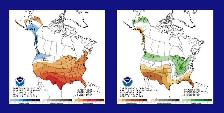
- The Climate Prediction Center's seasonal forecast favors above-normal temperatures and below-normal rainfall.
- Negative Arctic/North Atlantic Oscillation overwhelmed typical La Nina impacts in December and January.
- Drought development is a risk in the spring as La Nina plays out, especially in the lower ACF.
- The Alabama Office of Water Resources states no reported water availability issues and no changes to the Alabama Drought Declaration since 9/1/2020. Areas of abnormally dry (D0) have risen from 5% to 23% of the state in the past week (as of January 19, 2021).
Current U.S. Drought Monitor (USDM) map for the ACF River Basin with data valid for January 26, 2021. The USDM is updated each Thursday to show the location and intensity of drought across the country. Drought categories show experts’ assessments of conditions related to dryness and drought including observations of how much water is available in streams, lakes, and soils compared to usual for the same time of year. Learn more.
According to the most recent USDM, 0% of the ACF River Basin is in drought.
U.S. Drought Monitor Categories
Current U.S. Drought Monitor (USDM) map for the ACF River Basin with data valid for January 26, 2021. The USDM is updated each Thursday to show the location and intensity of drought across the country. Drought categories show experts’ assessments of conditions related to dryness and drought including observations of how much water is available in streams, lakes, and soils compared to usual for the same time of year. Learn more.
According to the most recent USDM, 0% of the ACF River Basin is in drought.
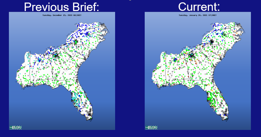
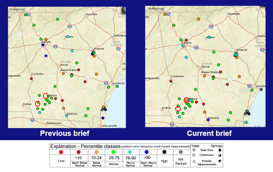
Real-Time Streamflow & Forecasts
- Real-time streamflows in the ACF basin are currently in the high to much below normal range.
- The upper Flint River basin is currently ranked as moderate hydrologic drought for the 7-day average streamflow.
- The 28-day average streamflow for the Chattahoochee River is currently in the above normal to normal range.
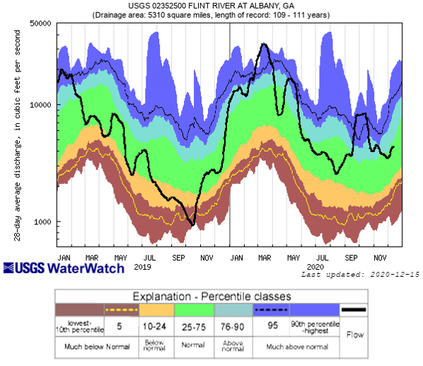
- The 28-day average streamflow for the Flint River is currently in the normal range.
- Real-time groundwater levels across the ACF basin range from above normal to low, with most stations ranked in the normal range.
- Flooding is not anticipated in the short-term in the ACF.
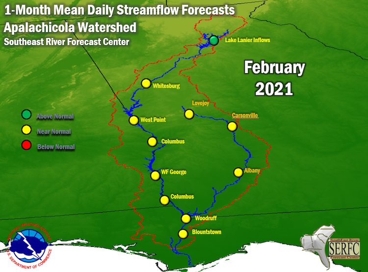
- The National Weather Service Southeast River Forecast Center's 1-month streamflow forecast: near normal, with above-normal flows on the far upper Chattahoochee.
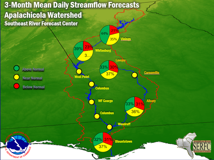
- The Southeast River Forecast Center's 3-month streamflow forecast: near normal.
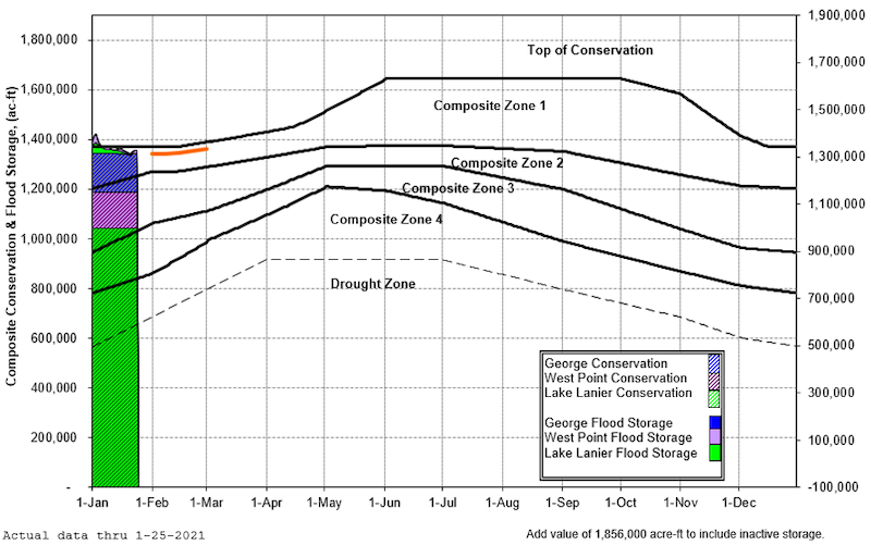
ACF Basin Reservoir Conditions
- Inflows into the projects are normal/above normal.
- Currently, projects are operating slightly above/right at winter pool elevations
- The ACF system conservation storage is in Zone 1 and is forecasted to stay in Zone 1 for the next few weeks.
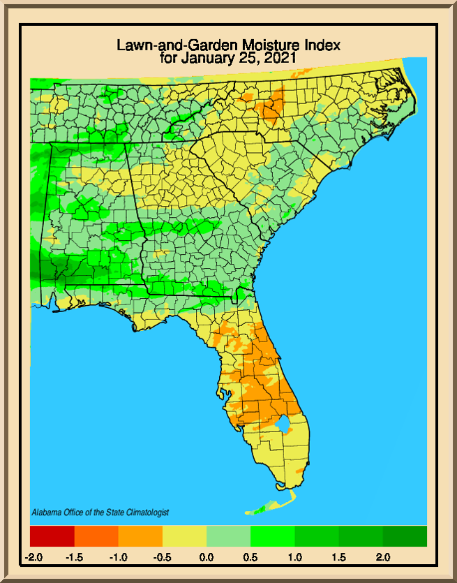
Lawn and Garden Moisture Index
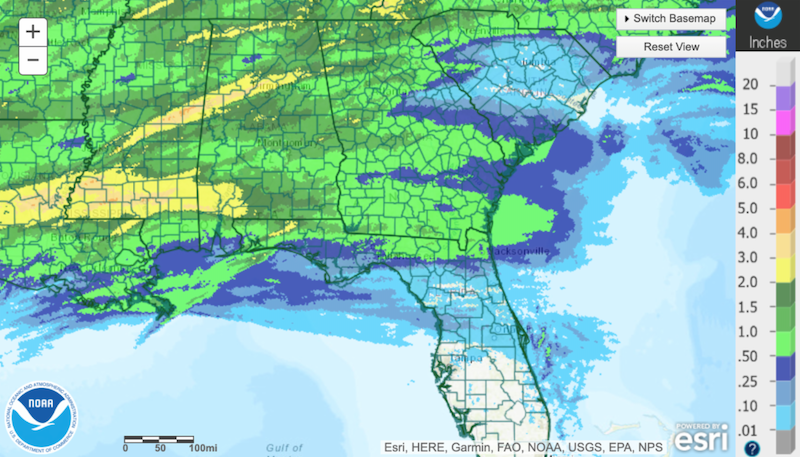
Rainfall Totals and Departures
7-Day Precipitation Totals
30-Day Precipitation Totals
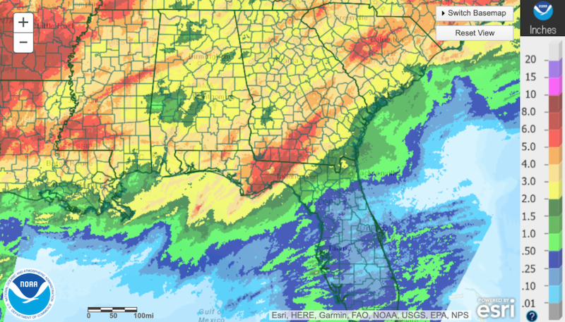
90-Day Precipitation Departures

NOAA Seasonal Outlook (February - April)
Real-time Streamflow
Flint River at Albany
28-Day Average Streamflows
Real-Time Groundwater Conditions
ACF Reservoir Conditions
2021 ACF Basin Composite Conservation and Flood Storage
1-Month & 3-Month Mean Daily Streamflow Forecasts
1-Month Mean Daily Streamflow Forecast: February 2021
Acknowledgments
Speakers:
David Zierden, Florida State University
Tom Littlepage, ADECA Office of Water Resources
Paul Ankcorn, U.S. Geological Survey
Troy Ephriam, U.S. Army Corps of Engineers - Mobile District
Jeff Dobur, National Weather Service Southeast River Forecast Center
Hamid Moradkhani, University of Alabama
Summary Prepared By:
Rachel McGuire, Auburn University
Resources
- National Drought Mitigation Center
- ADECA Office of Water Resources
- Drought Impact Reporter
- Southeast Climate Perspectives Map
- General Climate and El Niño Information: AgroClimate
- Streamflow Monitoring & Forecasting: USGS WaterWatch and Southeast River Forecast Center
- Groundwater Monitoring: USGS Groundwater Watch
- The Complete Set of Briefing Slides From the ACF River Basin Drought Webinar
- Additional Information From the Southeast River Forecast Center: 10-Day Guidance Forecasts and Official River Stage and Flow Forecasts
Join the ACF mailing list to receive email updates. For webinar-related questions, please contact Rachel McGuire (rem@auburn.edu).