Wetter than normal conditions expected to persist across Puerto Rico and the Virgin Islands, and drought development is unlikely through the rest of the year.
Key Points
- Tropical Cyclone Ernesto, along with other weather systems, brought significant rainfall to Puerto Rico and the Virgin Islands, maintaining saturated soils and elevated streams and keeping the water reservoirs replenished.
- Key impacts in Puerto Rico: July and August were months of continuous rains that impacted farms and food production in Puerto Rico. The passage of Tropical Storm Ernesto in mid-August caused landslides and damage to access roads to farms, as well as flooding and crop losses. Rains also led to an incidence of fungi and crop damage in some areas with high humidity, such as the island municipalities of Vieques and Culebra. Farmers reported dry patches in some regions of the southwest.
- Key impacts in the U.S. Virgin Islands: Fruit trees and crops were impacted by the heavy rain and high winds from Tropical Storm Ernesto. The storm also created silt plumes on the islands that increased sediment in the coastal waters and impacted some fisheries.
- Looking ahead: The wet pattern is expected to continue throughout the fall and early winter months. Conditions will remain favorable for tropical cyclone formation in the vicinity of the Caribbean Islands through the end of November.
See below for additional details on current conditions, impacts (including streamflow and soil moisture), and outlooks (including the hurricane outlook).
U.S. Drought Monitor map for Puerto Rico and the U.S. Virgin Islands, as of September 17, 2024. The U.S. Drought Monitor is updated each Thursday to show the location and intensity of drought across the country.
The map uses 5 classifications: Abnormally Dry (D0), showing areas that may be going into or are coming out of drought, and four levels of drought (D1–D4).
A drought index combines multiple drought indicators (e.g., precipitation, temperature, soil moisture) to depict drought conditions. For some products, like the U.S. Drought Monitor, authors combine their analysis of drought indicators with input from local observers. Other drought indices, like the Standardized Precipitation Index (SPI), use an objective calculation to describe the severity, location, timing, and/or duration of drought.
Learn MorePeriods of drought can lead to inadequate water supply, threatening the health, safety, and welfare of communities. Streamflow, groundwater, reservoir, and snowpack data are key to monitoring and forecasting water supply.
Learn MoreDrought can reduce the water availability and water quality necessary for productive farms, ranches, and grazing lands, resulting in significant negative direct and indirect economic impacts to the agricultural sector. Monitoring agricultural drought typically focuses on examining levels of precipitation, evaporative demand, soil moisture, and surface/groundwater quantity and quality.
Learn MoreU.S. Drought Monitor
D0 - Abnormally Dry
Abnormally Dry (D0) indicates a region that is going into or coming out of drought, according to the U.S. Drought Monitor. View typical impacts by state.
D1 – Moderate Drought
Moderate Drought (D1) is the first of four drought categories (D1–D4), according to the U.S. Drought Monitor. View typical impacts by state.
D2 – Severe Drought
Severe Drought (D2) is the second of four drought categories (D1–D4), according to the U.S. Drought Monitor. View typical impacts by state.
D3 – Extreme Drought
Extreme Drought (D3) is the third of four drought categories (D1–D4), according to the U.S. Drought Monitor. View typical impacts by state.
D4 – Exceptional Drought
Exceptional Drought (D4) is the most intense drought category, according to the U.S. Drought Monitor. View typical impacts by state.
U.S. Drought Monitor map for Puerto Rico and the U.S. Virgin Islands, as of September 17, 2024. The U.S. Drought Monitor is updated each Thursday to show the location and intensity of drought across the country.
The map uses 5 classifications: Abnormally Dry (D0), showing areas that may be going into or are coming out of drought, and four levels of drought (D1–D4).
The U.S. Drought Monitor is updated weekly on Thursday morning, with data valid through that Tuesday at 7 a.m. ET.
A drought index combines multiple drought indicators (e.g., precipitation, temperature, soil moisture) to depict drought conditions. For some products, like the U.S. Drought Monitor, authors combine their analysis of drought indicators with input from local observers. Other drought indices, like the Standardized Precipitation Index (SPI), use an objective calculation to describe the severity, location, timing, and/or duration of drought.
Learn MorePeriods of drought can lead to inadequate water supply, threatening the health, safety, and welfare of communities. Streamflow, groundwater, reservoir, and snowpack data are key to monitoring and forecasting water supply.
Learn MoreDrought can reduce the water availability and water quality necessary for productive farms, ranches, and grazing lands, resulting in significant negative direct and indirect economic impacts to the agricultural sector. Monitoring agricultural drought typically focuses on examining levels of precipitation, evaporative demand, soil moisture, and surface/groundwater quantity and quality.
Learn MoreCurrent Drought and Climate Conditions
- Puerto Rico has been drought free since late April, and the Virgin Islands since late February.
- Most of Puerto Rico experienced above-normal precipitation through the last two months.
- The most significant weather event during this period was Tropical Cyclone Ernesto, which brought significant flooding to the interior, west, east, and northern portions of Puerto Rico. Rainfall amounts reached nearly 15 inches in a 48-hour period along the interior municipalities.
- Aside from Ernesto, plenty of moisture and nearby troughs maintained a persistent wetter-than-normal pattern in the area. In fact, some places (such as northern Cabo Rojo) experienced a significant increase in minor flooding events.
- Year-to-date, locations near Paraiso in Ceiba Municipality and Maricao saw over 90 inches of rain. In contrast, areas such as Guayama and the southernmost portions of Cabo Rojo were drier than normal.
- Well-above-normal precipitation was observed across the U.S. Virgin Islands (USVI) in the last 60 days.
- In St. Croix, amounts ranged from nearly 9 to over 20 inches of rainfall, while 13 to 17 inches of rainfall were collected in St. Thomas and St. John.
- The islands were impacted by former Tropical Storm Ernesto, with the center moving very close to St. John and St. Thomas. Year-to-date, several locations in St. Croix and St. Thomas have already seen more than 50 inches of rain. As a result, there was an increase in flooding reports.
Figure 1: Rainfall Trends in Puerto Rico
Key Takeaway: Almost all of Puerto Rico observed above-normal rainfall in the past 60 days. Most of the area was 8 to 11 inches above normal, with some areas in the interior and west collecting over 16 inches more than normal.
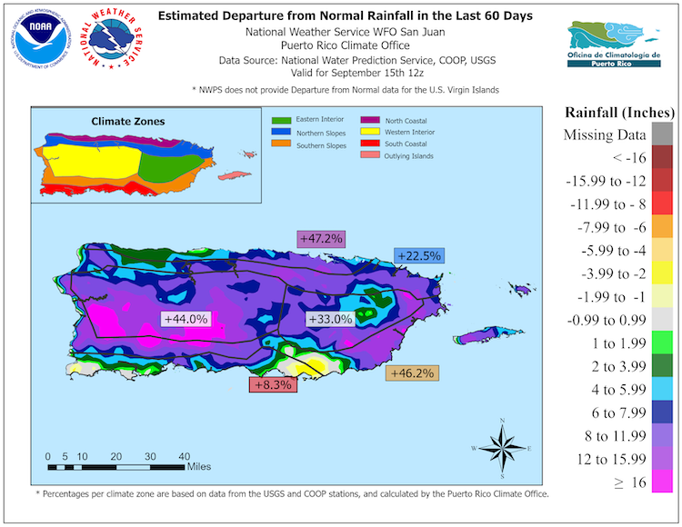
Figure 2: Trends in U.S. Virgin Islands Groundwater Wells
Key Takeaway: The nearly continuous rainfall events across the Virgin Islands and Puerto Rico were beneficial to the underground wells monitored by the U.S. Geological Survey. The well in St. Croix recovered to levels not seen since March 2021.
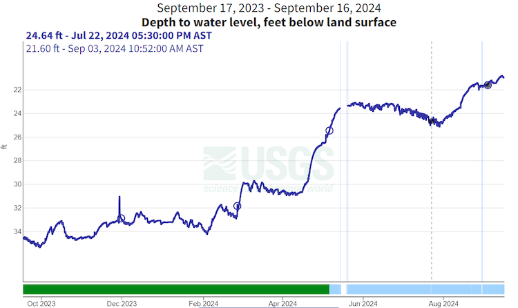
Figure 3: Trends in Temperature and Precipitation: Hot and Wet
Key Takeaway: Mean temperatures over the past two months were 1 to 2 degrees Fahrenheit above average across the region. Several stations ranked in the top 3 warmest for the period July 16–September 17 (with San Juan recording its warmest mean temperature over this two-month period) in a record going back to 1898. This continues a trend of record warm temperatures in the region that extends back over the past two years.
Precipitation totals over the past two months were above average across Puerto Rico, though none of these ranked in the top 10 for the period July 16–September 17. Maps for the USVI are not available due the lack of precipitation observations in July and August.
Drought Impacts for Puerto Rico and the U.S. Virgin Islands
- Report your Impacts: To report the effects of dry conditions on your farm projects for future Drought Updates, use the Drought Condition Monitoring Observations and Reports (CMOR) tool or join the USDA Caribbean Climate Hub reporter group chat on WhatsApp.
- Puerto Rico
- Central interior region (Cidra, Barranquitas): After Tropical Storm Ernesto passed, farmers reported weeks of rain, followed by dry and hot days. Last week there was no need to water the plants because of the rain. A few weeks ago a farmer reported fungus problems in crops due to the rain, but were able to control it. Unlike other atmospheric events, Ernesto did not have effects such as landslides and waterlogging on some farms.
- Northern region (Vega Baja / Morovis): High levels of humidity were reported as a result of rains, and this, together with the heat and the brief dry periods, deteriorated crops such as lettuce and other quick-harvest leaf crops. Conditions also affected tasks such as transplanting pepper crops.
- Northeast region (Canóvanas, San Juan): Road erosion was reported following Tropical Storm Ernesto and additional rain. The oversaturation of the soil impeded access to the farm on several occasions. This wilted some of the crops.
- Eastern island municipalities (Culebra and Vieques): This region usually experiences drier conditions than other regions, but has experienced increases in humidity due to rain in the past few weeks. An increase in weed growth was noted, which incurs more maintenance of gardens and farms. Humidity and rain are also causing an increase in the amount of fungi present in crops, such as lettuce and other short-cycle leaves. An increase in the Sigatoka fungus was seen in plantain and banana crops, a disease not common in these municipalities given their arid nature. The agricultural extensionist is recommending weekly defoliation of infected plants to prevent the fungus from spreading.
- Southeast region (Patillas, Yabucoa, Maunabo): The winds and rain from Ernesto damaged plantain and banana crops. Several farmers lost their crops. On the other hand, atypically dry conditions were also reported in other municipalities in the region. Dry conditions increased in most of the coast (Guayama, Salinas, and Arroyo) since mid-July. Grass and some trees are beginning to suffer stress due to very warm temperatures, dry soil, and less rainfall. Some forest fires were observed.
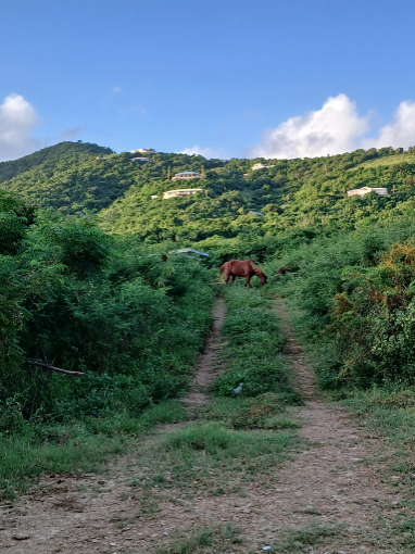
- Southern region (Coamo, Santa Isabel): A farmer reported using more irrigation than usual for the season at the end of August. They also reported that, although there is grass growing for forage, it is less than expected for the time of year. Green vegetation, moist soil, growing mushrooms, and rapid plant growth were observed. Rainy and hot conditions were notable in farm tasks.
- Southwestern region (Hormigueros, Cabo Rojo, Guánica, Lajas): Ernesto produced flooding on pastures and crops in some valleys. Oversaturation of the soil did not allow access to some farms. Some lands remained flooded for several days after the storm. Fallen bamboo was reported, impacting and destroying crops. Despite the dry, hot, and windy weather in mid-September, a cattle rancher in Lajas reported pastures held up fairly well. Another rancher from the southwest, near La Parguera in Lajas, reported while some nearby areas received rainfall, his farm and neighboring farms experienced scarce precipitation—only about 0.35 inches of rain, compared to 1.5 inches in surrounding areas. He describes this as a pocket of localized drought where no rain is falling.
- St. Thomas: Recent storms and rains filled ponds, and vegetation is bouncing back from previous dry periods. Livestock and poultry farmers have access to feed. Following Tropical Storm Ernesto, many farmers reported a lack of access to roads due to erosion and landslides on farms in the Bordeaux area, which impacted operations. Farms impacted by storm-associated flooding reported lost crops and downed fruit trees.
- St. John: Row and specialty crop farmers report that heavy rains have caused mold, mildew, and crop losses. Tropical Storm Ernesto downed fruit trees and caused additional losses from flooding. While some farms are focusing on post-storm clean up and land preparation, others are rotating crops and planting microgreens, fruit trees, and quick crops to keep production up.
- St. Croix:Tropical Storm Ernesto caused tree damage and soil loss that impacted operations. Livestock farmers are planning for potential feed shortages later in the year associated with hotter months. Rainfall Trends
Photo 1: Flooded Farmland after Tropical Storm Ernesto
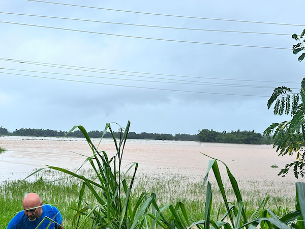
Photo 2: Limited Access Road to Pasture Lands on Farm Due to Flooding
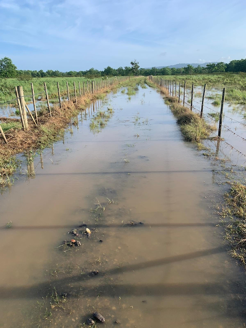
Photo 3: Silt Plumes from Tropical Storm Ernesto Impact Coastal Water Quality
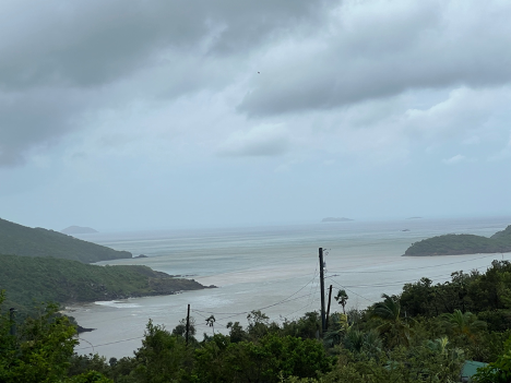
Photo 4: Recent Rains Increased Vegetation for Grazing
Puerto Rico Streamflow and Soil Moisture Impacts
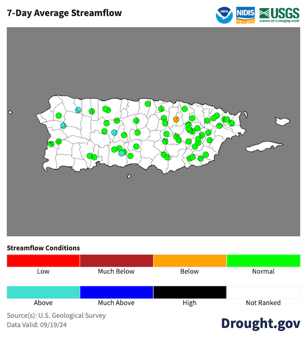
- Streamflows were running at normal- to much-above-normal levels through the period. Water reservoirs are at optimal levels.
- Soils remained saturated, with plenty of water available for plants and animals to use. The Crop Stress Factor was not a concern for most of the area, except for portions of southeastern Puerto Rico.
Figure 4: Crop Conditions in Puerto Rico
Key Takeaway: The latest crop stress factor data from the Puerto Rico Agricultural Water Management (PRAGWATER) indicates healthy vegetation levels across most of Puerto Rico. Some impacts due to isolated dryness are possible in the southernmost areas in Puerto Rico, especially in Guayama and Salinas.
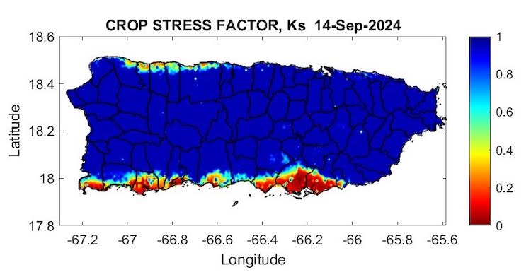
Figure 5: Streamflow Conditions in Puerto Rico
Key Takeaway: Rivers are running normal to above-normal across all of Puerto Rico, according to the 7-day average streamflow from the U.S. Geological Survey (USGS) river gauge network. View information on groundwater levels along the South Coast of Puerto Rico, or view current USVI groundwater conditions.
Outlooks and Potential Impacts for Puerto Rico and the U.S. Virgin Islands
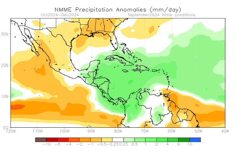
- Conditions are expected to remain on the wet side through the end of the calendar year. Most of the territories should remain free of dryness or drought, but isolated sections of the islands (such as southeastern Puerto Rico) may continue to experience below-normal rainfall.
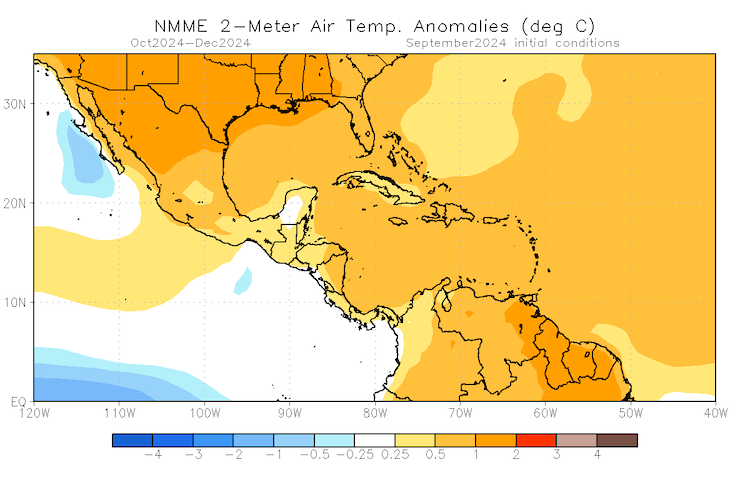
- In contrast, temperatures will also be above normal throughout the same period. Higher-than-normal temperatures could increase the evapotranspiration rates across the area, affecting the crops in these isolated areas that do not receive as much rain.
- No drought is expected to develop over the next three months in Puerto Rico or the USVI, according to the current NOAA Climate Prediction Center’s Seasonal Drought Outlook.
Figure 6: Seasonal Forecasts for Precipitation and Temperature
Key Takeaway: The wet pattern that the islands have been experiencing is expected to linger through the end of the calendar year. Under these conditions, drought is not expected to develop across the U.S. Caribbean territories. On the other hand, above-normal temperatures may lead to an increase in evapotranspiration, which could stress isolated areas that do not receive as much precipitation.
Hurricane Outlook
- The Global Tropics Hazards Outlook indicates conditions will remain favorable in the Main Development Region (between Africa and the Lesser Antilles) for tropical cyclone formation through the end of November. However, there is no imminent threat for the eastern Caribbean islands.
- The strongest tropical cyclones that usually impact Puerto Rico or the Virgin Islands are typically during the months of August/September. However, some storms have approached the area during the month of October or early November.
Additional Resources
National Weather Service Weather Forecast Office:
U.S. Drought Portal (Drought.gov):
USDA Caribbean Climate Hub: Drought and disaster assistance resources for tropical forestry and agriculture
Southeast Regional Climate Center: Quarterly Climate Impact and Outlook Reports, which includes Puerto Rico and U.S. Virgin Islands.
Prepared By
Emanuel Rodriguez
NOAA National Weather Service Weather Forecast Office San Juan
Héctor J. Jiménez
University of Puerto Rico Office of Climatology
Meredith Muth
NOAA National Integrated Drought Information System (NIDIS)
Victor Murphy
NOAA National Weather Service Southern Region
Christina Chanes
University of Virgin Islands
Silmarie Crespo Vélez, Nora Álvarez-Berríos
U.S. Department of Agriculture (USDA) Caribbean Climate Hub, USDA Forest Service International Institute of Tropical Forestry
Brad Rippey
USDA Office of the Chief Economist
Timothy Dalrymple
U.S. Geological Survey Caribbean–Florida Water Science Center (CFWSC)
Puerto Rico Reporting Input: Thanks to the Agricultural Extension Service, College of Agricultural Sciences, University of Puerto Rico-Mayaguez, South West Soil and Water Conservation District, Eastern Soil and Water Conservation District, and the Association of Cattle Ranchers, Moriviví Farm, Cordero Farm, Pasiflora Farm, KeFruits and Ke Foods Farm. Special thanks to agronomists, scientists, ranchers, and farmers: Betzaida Ortiz-Carrión, Diana Guzmán-Colón, Elvin Lebrón, Harry Ramírez, Hilda Bonilla, Joshua Ortíz, Isela Ortiz, Leilany Dávila, Luz Dahlia Jiménez, Merari Torres Amaro, Miguel Carlo, Samuel Rodríguez, and others.
USVI Reporting Input: Several individuals contributed to this report and we are acknowledging the following for their support including the farming community across the USVI, UVI faculty, staff, and collaborators of the UVI Department of Chemical and Physical Sciences, UVI Etelman Observatory, UVI Agricultural Experiment Station, VI Department of Agriculture, as well as the USDA Office Chief Economist, National Parks Service in St. Croix and St John, VI Department of Planning and Natural Resources, USDA Farm Service Agency, USDA Natural Resources Conservation Services in St Croix, Coral Bay Community Council and the many volunteer drought reporters, volunteers, and farmers from across the territory.
About This Report
This drought update is issued in partnership between the National Integrated Drought Information System (NIDIS), National Oceanic and Atmospheric Administration (NOAA) National Weather Service, the U.S. Department of Agriculture (USDA), and the University of the Virgin Islands. The purpose of the update is to communicate a potential area of concern for drought expansion and/or development within Puerto Rico and the U.S. Virgin Islands based on recent conditions and the upcoming three-month forecast.
NIDIS and its partners will issue these updates every two months. Subscribe for these U.S. Caribbean drought updates here.
