Fire
Drought can be a contributing factor to wildfire. Dry, hot, and windy weather combined with dried out (and more flammable) vegetation can increase the probability of large-scale wildfires.
Drought and Wildfire
The relationship between drought and fire is complex. The timing, intensity, and frequency of drought events have divergent impacts on fuel flammability and fire behavior. Rapidly drying abundant fuels in forest understories and grasslands after a wet spring can feed larger fires. Prolonged drought can limit fire occurrence as the availability of fuels (e.g., grasses) is reduced due to lack of precipitation.
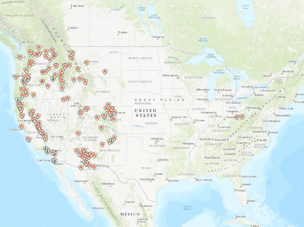
This map shows active large wildfires from the National Interagency Fire Center (NIFC) Incident Management Situation Reports, alongside current drought conditions from the U.S. Drought Monitor.
Note: This map only includes ongoing "large" wildland fires. It does not include prescribed burns, smaller fires, or other fires not included in NIFC's situation reports. View the latest situation report for more information.
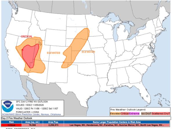
The National Weather Service's Storm Prediction Center produces daily fire weather outlooks, which delineate areas of the continental U.S. where pre-existing fuel conditions, combined with forecast weather conditions, will result in a significant threat for the ignition and/or spread of wildfires. This map shows the 1-day fire weather outlook, alongside the most recent U.S. Drought Monitor.
Extreme weather events can interact or cascade—where one disaster event triggers or changes the probability of another event. For example, drought conditions can increase the probability of large-scale wildfires, and droughts are often accompanied by extreme heat. By including drought in multi-hazard planning, a community can consolidate its resources and develop coordinated responses before a disaster.
Learn MoreDuring drought conditions, fuels for wildfire, such as grasses and trees, can dry out and become more flammable. Drought can also increase the probability of ignition and the rate at which fire spreads. Temperature, soil moisture, humidity, wind speed, and fuel availability (vegetation) are all factors that interact to influence the frequency of large wildfires.
Learn MoreExtreme weather events can interact or cascade—where one disaster event triggers or changes the probability of another event. For example, drought conditions can increase the probability of large-scale wildfires, and droughts are often accompanied by extreme heat. By including drought in multi-hazard planning, a community can consolidate its resources and develop coordinated responses before a disaster.
Learn MoreDuring drought conditions, fuels for wildfire, such as grasses and trees, can dry out and become more flammable. Drought can also increase the probability of ignition and the rate at which fire spreads. Temperature, soil moisture, humidity, wind speed, and fuel availability (vegetation) are all factors that interact to influence the frequency of large wildfires.
Learn MoreActive Large Wildfires
Large Fire
The National Interagency Coordination Center classifies "large" wildland fires as 100 acres or larger in timber and slash fuel models; 300 acres or larger in grass or brush fuel models; or when a Complex, Type 1, or Type 2 Incident Management Team is assigned.
U.S. Drought Monitor
D0 - Abnormally Dry
Abnormally Dry (D0) indicates a region that is going into or coming out of drought, according to the U.S. Drought Monitor. View typical impacts by state.
D1 – Moderate Drought
Moderate Drought (D1) is the first of four drought categories (D1–D4), according to the U.S. Drought Monitor. View typical impacts by state.
D2 – Severe Drought
Severe Drought (D2) is the second of four drought categories (D1–D4), according to the U.S. Drought Monitor. View typical impacts by state.
D3 – Extreme Drought
Extreme Drought (D3) is the third of four drought categories (D1–D4), according to the U.S. Drought Monitor. View typical impacts by state.
D4 – Exceptional Drought
Exceptional Drought (D4) is the most intense drought category, according to the U.S. Drought Monitor. View typical impacts by state.
Forecast Risk of Fire Weather
Elevated
Fire weather conditions are forecast to be elevated for temperature, wind, and relative humidity. Learn more about these designations.
Critical
Fire weather conditions are forecast to be critical for temperature, wind, and relative humidity. Learn more about these designations.
Extremely Critical
Fire weather conditions are forecast to be extremely critical for temperature, wind, and relative humidity. Learn more about these designations.
Isolated Dry Thunderstorms
The Storm Prediction Center has issued a forecast for isolated dry thunderstorms. This heightens the risk of fire ignition due to cloud-to-ground lightning, assuming a dry fuel bed. Learn more about these designations.
Scattered (Critical) Dry Thunderstorms
The Storm Prediction Center has issued a forecast for scattered (critical) dry thunderstorms. This heightens the risk of fire ignition due to cloud-to-ground lightning, assuming a dry fuel bed. Learn more about these designations.
U.S. Drought Monitor
D0 - Abnormally Dry
Abnormally Dry (D0) indicates a region that is going into or coming out of drought, according to the U.S. Drought Monitor. View typical impacts by state.
D1 – Moderate Drought
Moderate Drought (D1) is the first of four drought categories (D1–D4), according to the U.S. Drought Monitor. View typical impacts by state.
D2 – Severe Drought
Severe Drought (D2) is the second of four drought categories (D1–D4), according to the U.S. Drought Monitor. View typical impacts by state.
D3 – Extreme Drought
Extreme Drought (D3) is the third of four drought categories (D1–D4), according to the U.S. Drought Monitor. View typical impacts by state.
D4 – Exceptional Drought
Exceptional Drought (D4) is the most intense drought category, according to the U.S. Drought Monitor. View typical impacts by state.
This map shows active large wildfires from the National Interagency Fire Center (NIFC) Incident Management Situation Reports, alongside current drought conditions from the U.S. Drought Monitor.
Note: This map only includes ongoing "large" wildland fires. It does not include prescribed burns, smaller fires, or other fires not included in NIFC's situation reports. View the latest situation report for more information.
The National Weather Service's Storm Prediction Center produces daily fire weather outlooks, which delineate areas of the continental U.S. where pre-existing fuel conditions, combined with forecast weather conditions, will result in a significant threat for the ignition and/or spread of wildfires. This map shows the 1-day fire weather outlook, alongside the most recent U.S. Drought Monitor.
NIFC updates active large fire data daily or weekly, depending on the nation's National Preparedness Level. Learn more.
This map is updated daily with data from the National Weather Service's Storm Prediction Center. View more fire weather outlooks.
Extreme weather events can interact or cascade—where one disaster event triggers or changes the probability of another event. For example, drought conditions can increase the probability of large-scale wildfires, and droughts are often accompanied by extreme heat. By including drought in multi-hazard planning, a community can consolidate its resources and develop coordinated responses before a disaster.
Learn MoreDuring drought conditions, fuels for wildfire, such as grasses and trees, can dry out and become more flammable. Drought can also increase the probability of ignition and the rate at which fire spreads. Temperature, soil moisture, humidity, wind speed, and fuel availability (vegetation) are all factors that interact to influence the frequency of large wildfires.
Learn MoreExtreme weather events can interact or cascade—where one disaster event triggers or changes the probability of another event. For example, drought conditions can increase the probability of large-scale wildfires, and droughts are often accompanied by extreme heat. By including drought in multi-hazard planning, a community can consolidate its resources and develop coordinated responses before a disaster.
Learn MoreDuring drought conditions, fuels for wildfire, such as grasses and trees, can dry out and become more flammable. Drought can also increase the probability of ignition and the rate at which fire spreads. Temperature, soil moisture, humidity, wind speed, and fuel availability (vegetation) are all factors that interact to influence the frequency of large wildfires.
Learn MoreInciWeb is an interagency all-risk incident information management system.
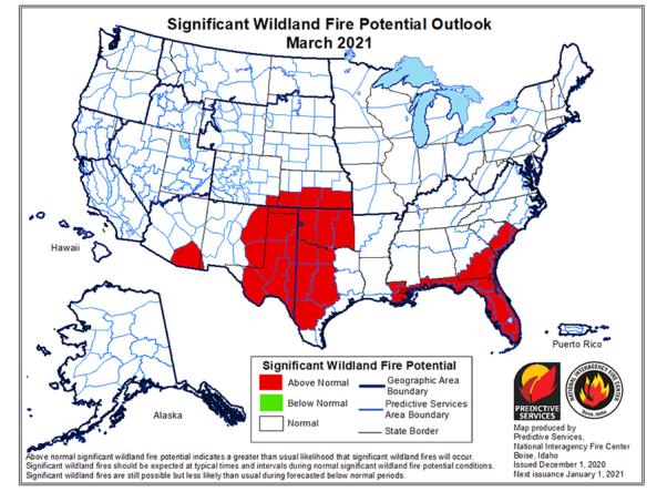
The National Significant Wildland Fire Potential Outlook is intended as a decision support tool for wildland fire managers, providing an assessment of current weather and fuels condition
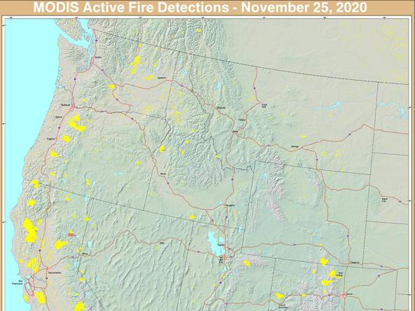
The USFS Active Fire Mapping program provides near real-time detection and characterization of wildland fire conditions in a geospatial context for the continental United States, Alaska, Hawaii and
A selection of NOAA fire and smoke products.
The National Weather Service's Fire Weather Outlooks are intended to delineate areas of the continental U.S.
Fire Research And Management Exchange System (FRAMES) provides a method of exchanging information and transferring technology among wildland fire researchers, managers, and other stakeholders in an
Impacts and Related Content
Exacerbation of Wildfire Conditions
Drought impacts can result in an increased volume and availability of live and dead fuels, increasing the probability of large-scale wildfires.
Drought in a Changing Climate
Drought, along with warming temperatures, can result in decreased snowpack and streamflow and increased evaporative demand, leading to increased wildfire potential.
By Sector | Wildfire Management
The negative impacts of wildfire can be reduced in some regions by thinning, using prescribed burns, and letting some fires burn if they will not affect people. Learn more about drought impacts on the wildfire management sector.


